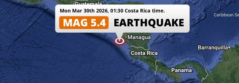
In the night of Monday March 30th, 2026, a significant M5.4 earthquake hit in the North Pacific Ocean 106 kilometer from Managua, Nicaragua. Around 5.4 million people have been exposed to shaking. Other countries near the epicenter include Costa Rica, Honduras and El Salvador.
Felt the earthquake? Share this article: 


Earthquake Summary
This earthquake hit under water in the North Pacific Ocean, 58 kilometers (36 mi) off the coast of Nicaragua, 106 kilometer southwest of Managua. The center of this earthquake had a quite shallow depth of 58 km. Shallow earthquakes usually have a larger impact than earthquakes deep in the earth.
| Date and Time: | Mar 30, 2026 01:30AM (Managua Time) - Mar 30, 2026 07:30 Universal Time. |
|---|---|
| Location: | 106 km SW of Managua, Nicaragua. Coordinates 11°24'55"N 86°53'34"W. |
| Map: | 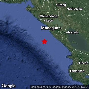 Map of area around epicenter. Click to open in Google Maps. |
| Magnitude: | MAG 5.4 Detected by 34 stations. Maximum Error Range ±0.053 . |
| Depth: | 58 km (36 mi) A quite shallow depth. |
| Max. Intensity: | V
Moderate On the Modified Mercalli Scale. |
| Tsunami Risk: | Low tsunami risk Earthquakes under MAG-6.5 do not usually cause tsunami's. Always stay cautious - More info here. |
Minimal impact predicted
Based on scientific estimates by the US Geographic Survey (USGS), the risk of high fatalities for this earthquake is classified at level GREEN (low). They expect an 90% likelyhood of between 0 and 1 fatalities.
The USGS classifies the economic impact of this earthquake at level GREEN (low). They expect an 90% likelyhood of between 0 and 1 million US Dollars in economic damage and impact.
Roughly 5.4 million people exposed to shaking
An estimated 5.4 million have been exposed to shaking (An MMI or Modified Mercalli Intensity level II or higher) as a result of this earthquake according scientific estimates published by the USGS.
Light shaking and likely no damage may have been experienced by an estimated 1,079,000 people. At IV, it is the highest MMI level this earthquake has caused. Intensity level III was experienced by the majority of people (around 3.8 million). In their region, weak shaking and probably no damage can be expected.
People in 4 countries have been exposed to shaking. In Nicaragua , around 4.8 million people, with impact levels up to IV (light shaking, likely no damage). Roughly 450 thousand people were exposed to shaking in Costa Rica . A smaller number of people were exposed in the following countries: Honduras and El Salvador.
| People | MMI Level | Shaking | Damage |
|---|---|---|---|
| 0 | I |
Not noticable | None |
| 519,800 | II |
Very weak | None |
| 3,763,000 | III |
Weak | Probably none |
| 1,079,000 | IV |
Light | Likely none |
| 0 | V |
Moderate | Very light |
| 0 | VI |
Strong | Light |
| 0 | VII |
Very Strong | Moderate |
| 0 | VIII |
Severe | Moderate to heavy |
| 0 | IX |
Violent | Heavy |
| 0 | X |
Extreme | Very heavy |
Nearby towns and cities
4 countries can be found within 300km of the epicenter of this earthquake: Nicaragua , Costa Rica , Honduras and El Salvador .
San Rafael del Sur in Managua, Nicaragua is the nearest significant place from the epicenter. The earthquake occurred 69 kilometer (43 mi) southwest of San Rafael del Sur. The intensity of shaking and damage in San Rafael del Sur is estimated to be around level IV on the Modified Mercalli Intensity scale (light shaking, likely no damage).
Major cities near this earthquake: Managua is located 106 km to the north-east and experienced an intensity of III (weak shaking, probably no damage). Tegucigalpa is located 298 km to the north (intensity unknown, possibly low). León is located 114 km to the north and experienced an intensity of IV (light shaking, likely no damage).
A complete list of nearby places is included below. Estimated intensity data (MMI) sourced from a shake-map published by the US Geographic Survey is shown where available (cities without data probably experienced little impact).
Overview of nearby places
| Distance | Place | Intensity (MMI) |
|---|---|---|
| 69 km (43 mi) NE from epicenter |
San Rafael del Sur Managua, Nicaragua. |
IV
Light |
| 87 km (54 mi) NE from epicenter |
Diriamba Carazo, Nicaragua. |
IV
Light |
| 90 km (56 mi) NE from epicenter |
Jinotepe Carazo, Nicaragua. |
IV
Light |
| 90 km (56 mi) NE from epicenter |
El Crucero Managua, Nicaragua. |
IV
Light |
| 93 km (58 mi) NE from epicenter |
San Marcos Carazo, Nicaragua. |
IV
Light |
| 99 km (62 mi) NE from epicenter |
Masatepe Masaya, Nicaragua. |
IV
Light |
| 99 km (62 mi) NE from epicenter |
Nandaime Granada, Nicaragua. |
IV
Light |
| 101 km (63 mi) N from epicenter |
Nagarote León, Nicaragua. |
IV
Light |
| 102 km (63 mi) NE from epicenter |
Ciudad Sandino Managua, Nicaragua. |
IV
Light |
| 105 km (65 mi) N from epicenter |
La Paz Centro León, Nicaragua. |
IV
Light |
| 106 km (66 mi) NE from epicenter |
Managua Managua, Nicaragua. |
III
Weak |
| 107 km (66 mi) NE from epicenter |
Masaya Masaya, Nicaragua. |
IV
Light |
| 114 km (71 mi) N from epicenter |
León León, Nicaragua. |
IV
Light |
| 116 km (72 mi) E from epicenter |
Rivas Rivas, Nicaragua. |
IV
Light |
| 117 km (73 mi) NE from epicenter |
Granada Granada, Nicaragua. |
III
Weak |
| 123 km (76 mi) NE from epicenter |
Tipitapa Managua, Nicaragua. |
IV
Light |
| 123 km (76 mi) N from epicenter |
Corinto Chinandega, Nicaragua. |
IV
Light |
| 130 km (81 mi) N from epicenter |
Chichigalpa Chinandega, Nicaragua. |
III
Weak |
| 137 km (85 mi) N from epicenter |
Chinandega Chinandega, Nicaragua. |
III
Weak |
| 142 km (88 mi) N from epicenter |
El Viejo Chinandega, Nicaragua. |
III
Weak |
| 178 km (111 mi) NE from epicenter |
Boaco Boaco, Nicaragua. |
III
Weak |
| 181 km (112 mi) N from epicenter |
Somotillo Chinandega, Nicaragua. |
III
Weak |
| 181 km (112 mi) SE from epicenter |
Liberia Guanacaste, Costa Rica. |
III
Weak |
| 183 km (114 mi) NE from epicenter |
Juigalpa Chontales, Nicaragua. |
III
Weak |
| 185 km (115 mi) NE from epicenter |
Camoapa Boaco, Nicaragua. |
III
Weak |
| 195 km (121 mi) N from epicenter |
Estelí Estelí, Nicaragua. |
III
Weak |
| 198 km (123 mi) E from epicenter |
San José Alajuela, Costa Rica. |
III
Weak |
| 199 km (124 mi) NE from epicenter |
Matagalpa Matagalpa, Nicaragua. |
III
Weak |
| 210 km (130 mi) NE from epicenter |
Jinotega Jinotega, Nicaragua. |
III
Weak |
| 211 km (131 mi) SE from epicenter |
Nicoya Guanacaste, Costa Rica. |
III
Weak |
| 212 km (132 mi) N from epicenter |
Ciudad Choluteca Choluteca, Honduras. |
|
| 224 km (139 mi) SE from epicenter |
Cañas Guanacaste, Costa Rica. |
III
Weak |
| 231 km (144 mi) N from epicenter |
San Lorenzo Valle, Honduras. |
|
| 232 km (144 mi) N from epicenter |
Somoto Madriz, Nicaragua. |
|
| 237 km (147 mi) NW from epicenter |
La Unión La Unión, El Salvador. |
|
| 248 km (154 mi) NE from epicenter |
Río Blanco Matagalpa, Nicaragua. |
II
Weak |
| 251 km (156 mi) N from epicenter |
Ocotal Nueva Segovia, Nicaragua. |
|
| 267 km (166 mi) E from epicenter |
Nueva Guinea South Caribbean Coast, Nicaragua. |
|
| 269 km (167 mi) NW from epicenter |
San Miguel San Miguel, El Salvador. |
|
| 270 km (168 mi) NW from epicenter |
San Rafael Oriente San Miguel, El Salvador. |
|
| 274 km (170 mi) NW from epicenter |
Usulután Usulután, El Salvador. |
|
| 275 km (171 mi) NW from epicenter |
Puerto El Triunfo Usulután, El Salvador. |
|
| 275 km (171 mi) N from epicenter |
El Paraíso El Paraíso, Honduras. |
|
| 276 km (171 mi) SE from epicenter |
Puntarenas Puntarenas, Costa Rica. |
|
| 280 km (174 mi) SE from epicenter |
Chacarita Puntarenas, Costa Rica. |
|
| 286 km (178 mi) NW from epicenter |
San Francisco Morazán, El Salvador. |
|
| 290 km (180 mi) SE from epicenter |
Esparza Puntarenas, Costa Rica. |
|
| 291 km (181 mi) N from epicenter |
Jalapa Nueva Segovia, Nicaragua. |
|
| 293 km (182 mi) N from epicenter |
Danlí El Paraíso, Honduras. |
|
| 295 km (183 mi) SE from epicenter |
Quesada Alajuela, Costa Rica. |
|
| 298 km (185 mi) N from epicenter |
Tegucigalpa Francisco Morazán, Honduras. |
Earthquake Intensity Map
The graph below overlays a map of the region around the epicenter with earthquake intensity data provided by the US Geographic Survey. The highest intensity level detected for this earthquake is IV.

3 Aftershocks detected
Since this main shock, 3 smaller aftershocks were detected. At a distance of 16 km (10 mi) north of this earthquake, an aftershock struck 11 mins later. It measured a magnitude of 3.3
This main shock was prefaced by 5 smaller foreshocks. A 3.3 magnitude earthquake hit 3 days earlier nearby.
Overview of foreshocks and aftershocks
| Classification | Magnitude | When | Where |
|---|---|---|---|
| Foreshock | M 3.3 |
3 days earlier Mar 27, 2026 04:48AM (Managua Time) | 27 km (17 mi) SE from Main Shock. |
| Foreshock | M 2.5 |
3 days earlier Mar 27, 2026 09:38AM (Managua Time) | 55 km (34 mi) NW from Main Shock. |
| Foreshock | M 3.2 |
2 days earlier Mar 28, 2026 05:07AM (Managua Time) | 83 km (52 mi) NW from Main Shock. |
| Foreshock | M 3.0 |
1 day earlier Mar 28, 2026 01:37PM (Managua Time) | 98 km (61 mi) E from Main Shock. |
| Foreshock | M 3.0 |
9 hrs earlier Mar 29, 2026 04:35PM (Managua Time) | 87 km (54 mi) NW from Main Shock. |
| Main Shock This Earthquake |
M 5.4 |
Mar 30, 2026 01:30AM (Managua Time) | - |
| Aftershock | M 3.3 |
11 mins later Mar 30, 2026 01:41AM (Managua Time) | 16 km (10 mi) N from Main Shock. |
| Aftershock | M 3.2 |
2 hrs later Mar 30, 2026 03:08AM (Managua Time) | 14 km (9 mi) SW from Main Shock. |
| Aftershock | M 3.2 |
2 hrs later Mar 30, 2026 03:16AM (Managua Time) | 23 km (14 mi) SW from Main Shock. |
More earthquakes coming?
Earthquakes can create aftershocks. These are generally at least 1 magnitude lower than any main shock, and as time passes the chance and strength of aftershocks decreases.
It's always adviced to be cautious of the risk of a larger shock following any significant earthquake, however this risk is fairly small. There is a roughly 94 percent change that no larger main shock will follow in the days following this earthquake.
Read: How to Stay Safe during an Earthquake (cdc.gov).Earthquakes like this happen often in the region
Earthquakes of this strength are very common in the region. This is the strongest earthquake to hit since March 26th, 2026, when a 5.5 magnitude earthquake hit 95 km (59 mi) further north-east. An even stronger magnitude 6.9 earthquake struck on November 24th, 2016.
In total, 35 earthquakes with a magnitude of 5.4 or higher have been registered within 300km (186 mi) of this epicenter in the past 10 years. This comes down to an average of once every 3 months.
Low tsunami risk
Based on early data it appears this earthquake was not strong enough (lower than MAG-6.5) to be likely to cause destructive tsunami's. However this earthquake appeared to have hit at a shallow depth under sea, so stay cautious and monitor advice from local authorities.
Tsunami Risk Factors
| Factor | Under Sea? | MAG-6.5 or stronger? | Shallow depth? |
|---|---|---|---|
| Explanation | Almost all tsunami's are caused by earthquakes with their epicenter under sea or very near the sea. However stay cautious in coastal areas as earthquakes on land may cause landslides into sea, potentially still causing a local tsunami. | Under MAG 6.5: Very unlikely to cause a tsunami. MAG 6.5 to 7.5: Destructive tsunami's do occur, but are uncommon. Likely to observe small sea level changes. MAG 7.6+: Earthquakes with these magnitudes might produce destructive tsunami's. |
Most destructive tsunami's are caused by shallow earthquakes with a depth between 0 and 100km under the surface of the earth. Deeper tsunami's are unlikely to displace to ocean floor. |
| This Earthquake | This earthquake appears to have struck under the sea. | Not this earthquake. This earthquake had a magnitude of 5.4. Earthquakes of this strength are unlikely to trigger a tsunami. |
This earthquake occurred at a depth of of 58 km (36 mi). Earthquakes this shallow could trigger a tsunami. |
Sources
Last updated 31/03/26 21:18 (). This article contains currently available information about the earthquake and is automatically composed. We continue to update this article up to a few days after the earthquake occurred.
- US Geographic Society (USGS): Earthquake us7000s8pl
- European-Mediterranean Seismological Centre (EMSC): Earthquake 20260330_0000103
- Geonames.org: World Cities Database
- Google Maps: Static API
- Earthquakelist.org: Historic Earthquakes Database
Share this article:
