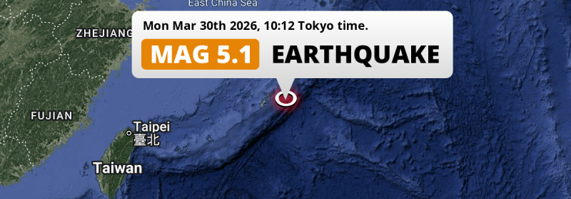
A shallow and significant Magnitude 5.1 earthquake struck in the Philippine Sea 97 kilometer from Gushikawa, Japan in the morning of Monday March 30th, 2026.
Felt the earthquake? Share this article: 


Earthquake Summary
This earthquake hit under water in the Philippine Sea, 79 kilometers (49 mi) off the coast of Japan, 97 kilometer east of Gushikawa in Okinawa. The center of this earthquake had a very shallow depth of 10 km. Shallow earthquakes usually have a larger impact than earthquakes deep in the earth.
| Date and Time: | Mar 30, 2026 10:12 (Tokyo Time) - Mar 30, 2026 01:12 Universal Time. |
|---|---|
| Location: | 97 km east of Gushikawa, Okinawa, Japan. Coordinates 26°12'56"N 128°49'34"E. |
| Map: | 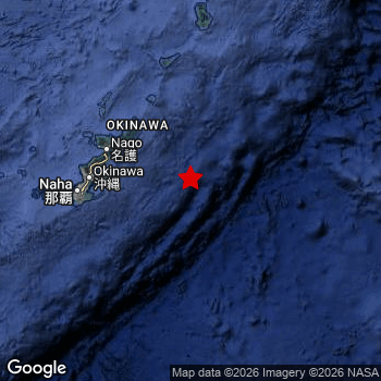 Map of area around epicenter. Click to open in Google Maps. |
| Magnitude: | MAG 5.1 Detected by 11 stations. Maximum Error Range ±0.093 . |
| Depth: | 10 km (6 mi) A very shallow depth. |
| Tsunami Risk: | Low tsunami risk Earthquakes under MAG-6.5 do not usually cause tsunami's. Always stay cautious - More info here. |
Nearby towns and cities
This earthquake may have been felt in Japan . The closest significant population center near the earthquake is Nago in Okinawa, Japan. Nago is located 95 kilometer (59 mi) south-east of the epicenter.
An overview of nearby towns and cities is available in the overview below.
Overview of nearby places
| Distance | Place |
|---|---|
| 95 km (59 mi) NW from epicenter |
Nago Okinawa, Japan. |
| 96 km (60 mi) W from epicenter |
Katsuren-haebaru Okinawa, Japan. |
| 97 km (60 mi) W from epicenter |
Gushikawa Okinawa, Japan. |
| 103 km (64 mi) W from epicenter |
Okinawa Okinawa, Japan. |
| 103 km (64 mi) W from epicenter |
Ishikawa Okinawa, Japan. |
| 106 km (66 mi) W from epicenter |
Ginowan Okinawa, Japan. |
| 106 km (66 mi) W from epicenter |
Chatan Okinawa, Japan. |
| 107 km (66 mi) W from epicenter |
Yonabaru Okinawa, Japan. |
| 110 km (68 mi) W from epicenter |
Yomitan Okinawa, Japan. |
| 114 km (71 mi) W from epicenter |
Naha Okinawa, Japan. |
| 114 km (71 mi) W from epicenter |
Tomigusuku Okinawa, Japan. |
| 116 km (72 mi) W from epicenter |
Itoman Okinawa, Japan. |
| 248 km (154 mi) N from epicenter |
Naze Kagoshima, Japan. |
Shaking reported by 1 person
People that feel an earthquake may report their experience to the US Geographic Survey. Currently, 1 person has reported shaking in one place in Japan.We keep updating this article as more ground reports become available. You may report that you felt this earthquake here.
Places with most reports:
- Ginowan, Okinawa, Japan: 1 person.
Aftershocks detected
After this earthquake struck, 1 smaller aftershock occurred. Just 33 mins after this main shock, an earthquake measuring MAG-4.7 was detected 4 km (2.6 mi) southwest of this earthquake.
This main shock was prefaced by 1 smaller foreshock. Roughly 1 hr before this earthquake, a foreshock measuring MAG-4.6 was detected nearby this earthquake.
Overview of foreshocks and aftershocks
| Classification | Magnitude | When | Where |
|---|---|---|---|
| Foreshock | M 4.6 |
1 hr earlier Mar 30, 2026 11:12 (Tokyo Time) | 21 km (13 mi) SW from Main Shock. |
| Main Shock | M 4.7 |
Mar 30, 2026 12:31 (Tokyo Time) | - |
| Aftershock | M 4.7 |
33 mins later Mar 30, 2026 13:04 (Tokyo Time) | 4 km (2.6 mi) SW from Main Shock. |
More earthquakes coming?
Earthquakes can create aftershocks. These are generally at least 1 magnitude lower than any main shock, and as time passes the chance and strength of aftershocks decreases.
It's always adviced to be cautious of the risk of a larger shock following any significant earthquake, however this risk is fairly small. There is a roughly 94 percent change that no larger main shock will follow in the days following this earthquake.
Read: How to Stay Safe during an Earthquake (cdc.gov).Earthquakes like this happen often in the region
Earthquakes of this strength are very common in the region. This is the strongest earthquake to hit since February 12th, 2026, when a 5.5 magnitude earthquake hit 55 km (34 mi) further southwest. An even stronger magnitude 6.6 earthquake struck on June 13th, 2020.
In total, 56 earthquakes with a magnitude of 5.1 or higher have been registered within 300km (186 mi) of this epicenter in the past 10 years. This comes down to an average of once every 2 months.
Low tsunami risk
Based on early data it appears this earthquake was not strong enough (lower than MAG-6.5) to be likely to cause destructive tsunami's. However this earthquake appeared to have hit at a shallow depth under sea, so stay cautious and monitor advice from local authorities.
Tsunami Risk Factors
| Factor | Under Sea? | MAG-6.5 or stronger? | Shallow depth? |
|---|---|---|---|
| Explanation | Almost all tsunami's are caused by earthquakes with their epicenter under sea or very near the sea. However stay cautious in coastal areas as earthquakes on land may cause landslides into sea, potentially still causing a local tsunami. | Under MAG 6.5: Very unlikely to cause a tsunami. MAG 6.5 to 7.5: Destructive tsunami's do occur, but are uncommon. Likely to observe small sea level changes. MAG 7.6+: Earthquakes with these magnitudes might produce destructive tsunami's. |
Most destructive tsunami's are caused by shallow earthquakes with a depth between 0 and 100km under the surface of the earth. Deeper tsunami's are unlikely to displace to ocean floor. |
| This Earthquake | This earthquake appears to have struck under the sea. | Not this earthquake. This earthquake had a magnitude of 5.1. Earthquakes of this strength are unlikely to trigger a tsunami. |
This earthquake occurred at a depth of of 10 km (6 mi). Earthquakes this shallow could trigger a tsunami. |
Sources
Last updated 31/03/26 18:58 (). This article contains currently available information about the earthquake and is automatically composed. We continue to update this article up to a few days after the earthquake occurred.
- US Geographic Society (USGS): Earthquake us7000s8mj
- European-Mediterranean Seismological Centre (EMSC): Earthquake 20260330_0000005
- Geonames.org: World Cities Database
- Google Maps: Static API
- Earthquakelist.org: Historic Earthquakes Database
Share this article:
