In the Banda Sea 372 kilometer from Atambua, Indonesia, a significant M5.8 earthquake occurred deep in the night of Sunday March 29th, 2026. Shaking may have been felt by a total of 420 thousand people. Another country near the epicenter is Timor-Leste.
Felt the earthquake? Share this article: 


Earthquake Summary
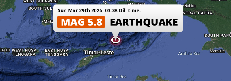
This earthquake hit under water in the Banda Sea, 41 kilometers (26 mi) off the coast of Indonesia, 372 kilometer north-east of Atambua in East Nusa Tenggara. The center of this earthquake had an intermediate depth of 159 km.
| Date and Time: | Mar 29, 2026 03:38 (Dili Time) - Mar 28, 2026 18:38 Universal Time. |
|---|---|
| Location: | 277 km NE of Dili, Díli, Timor-Leste. Coordinates 7°30'26"S 127°51'28"E. |
| Map: | 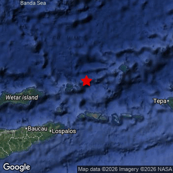 Map of area around epicenter. Click to open in Google Maps. |
| Magnitude: | MAG 5.8 Detected by 59 stations. Maximum Error Range ±0.04 . |
| Depth: | 159 km (99 mi) An intermediate depth. |
| Max. Intensity: | IV
Light On the Modified Mercalli Scale. |
| Tsunami Risk: | Tsunami very unlikely Earthquakes under MAG-6.5 at depths deeper than 100km are very unlikely to cause tsunami's. Always stay cautious - More info here. |
Minimal impact predicted
Based on scientific estimates by the US Geographic Survey (USGS), the risk of high fatalities for this earthquake is classified at level GREEN (low). They expect an 90% likelyhood of between 0 and 1 fatalities.
The USGS classifies the economic impact of this earthquake at level GREEN (low). They expect an 90% likelyhood of between 0 and 1 million US Dollars in economic damage and impact.
Roughly 420 thousand people exposed to shaking
The USGS has published a report estimating the number of people exposed to this earthquake. Acoording to their analysis, roughly 420 thousand have been exposed to shaking at an MMI level of II or higher.
An estimated 3,330 people were exposed to level IV. At this level, light shaking and likely no damage can be expected. Intensity level III was experienced by the majority of people (around 380 thousand). In their region, weak shaking and probably no damage can be expected.
People in 2 countries have been exposed to shaking. In Indonesia , around 70 thousand people, with impact levels up to IV (light shaking, likely no damage). In Timor-Leste , around 350 thousand people.
| People | MMI Level | Shaking | Damage |
|---|---|---|---|
| 0 | I |
Not noticable | None |
| 27,660 | II |
Very weak | None |
| 384,500 | III |
Weak | Probably none |
| 3,330 | IV |
Light | Likely none |
| 0 | V |
Moderate | Very light |
| 0 | VI |
Strong | Light |
| 0 | VII |
Very Strong | Moderate |
| 0 | VIII |
Severe | Moderate to heavy |
| 0 | IX |
Violent | Heavy |
| 0 | X |
Extreme | Very heavy |
Nearby towns and cities
This earthquake struck within proximity of multiple countries. Timor-Leste and Indonesia are both within 300km distance of its epicenter.
Located 147 kilometer (91 mi) north-east of the epicenter of this earthquake, Lospalos (Lautém, Timor-Leste) is the nearest significant population center. The intensity of shaking and damage in Lospalos is estimated to be around level III on the Modified Mercalli Intensity scale (weak shaking, probably no damage).
A complete list of nearby places is included below. Estimated intensity data (MMI) sourced from a shake-map published by the US Geographic Survey is shown where available (cities without data probably experienced little impact).
Overview of nearby places
| Distance | Place | Intensity (MMI) |
|---|---|---|
| 147 km (91 mi) SW from epicenter |
Lospalos Lautém, Timor-Leste. |
III
Weak |
| 188 km (117 mi) SW from epicenter |
Baukau Baucau, Timor-Leste. |
III
Weak |
| 206 km (128 mi) SW from epicenter |
Venilale Baucau, Timor-Leste. |
III
Weak |
| 277 km (172 mi) SW from epicenter |
Dili Díli, Timor-Leste. |
|
| 286 km (178 mi) SW from epicenter |
Aileu Aileu, Timor-Leste. |
|
| 302 km (188 mi) SW from epicenter |
Likisá Liquiçá, Timor-Leste. |
|
| 317 km (197 mi) SW from epicenter |
Maubara Liquiçá, Timor-Leste. |
|
| 334 km (208 mi) SW from epicenter |
Maliana Bobonaro, Timor-Leste. |
|
| 350 km (217 mi) SW from epicenter |
Suai Cova Lima, Timor-Leste. |
|
| 372 km (231 mi) SW from epicenter |
Atambua East Nusa Tenggara, Indonesia. |
Earthquake Intensity Map
The intensity in shaking and damage by this earthquake is illustrated through the map below. The highest intensity measured for this earthquake is IV.

Shaking reported by 2 people
People that feel an earthquake may report their experience to the US Geographic Survey. Currently, 2 people have reported shaking in one place in East Timor.We keep updating this article as more ground reports become available. You may report that you felt this earthquake here.
Places with most reports:
- Dili, Dili, East Timor: 2 people.
5 Aftershocks detected
After this earthquake struck, 5 smaller aftershocks occurred. Just 1 day after this main shock, an earthquake measuring MAG-4.8 was detected 79 km (49 mi) east of this earthquake.
This main shock was prefaced by 1 smaller foreshock. Nearby this earthquake a foreshock struck 2 days earlier. It measured a magnitude of 4.3
Overview of foreshocks and aftershocks
| Classification | Magnitude | When | Where |
|---|---|---|---|
| Foreshock | M 4.3 |
2 days earlier Mar 27, 2026 05:13 (Dili Time) | 17 km (10 mi) SW from Main Shock. |
| Main Shock This Earthquake |
M 5.8 |
Mar 29, 2026 03:38 (Dili Time) | - |
| Aftershock | M 4.2 |
16 hrs later Mar 29, 2026 19:09 (Dili Time) | 78 km (48 mi) NW from Main Shock. |
| Aftershock | M 2.7 |
22 hrs later Mar 30, 2026 01:30 (Dili Time) | 47 km (29 mi) SW from Main Shock. |
| Aftershock | M 4.3 |
1 day later Mar 30, 2026 11:36 (Dili Time) | 56 km (35 mi) E from Main Shock. |
| Aftershock | M 4.8 |
1 day later Mar 30, 2026 13:00 (Dili Time) | 79 km (49 mi) E from Main Shock. |
| Aftershock | M 3.3 |
2 days later Mar 31, 2026 05:17 (Dili Time) | 38 km (23 mi) S from Main Shock. |
More earthquakes coming?
Earthquakes can create aftershocks. These are generally at least 1 magnitude lower than any main shock, and as time passes the chance and strength of aftershocks decreases.
It's always adviced to be cautious of the risk of a larger shock following any significant earthquake, however this risk is fairly small. There is a roughly 94 percent change that no larger main shock will follow in the days following this earthquake.
Read: How to Stay Safe during an Earthquake (cdc.gov).Earthquakes like this happen often in the region
Earthquakes of this strength are very common in the region. This is the strongest earthquake to hit since October 28th, 2025, when a 6.4 magnitude earthquake hit 252 km (156 mi) further east. An even stronger magnitude 7.6 earthquake struck on January 9th, 2023.
In total, 21 earthquakes with a magnitude of 5.8 or higher have been registered within 300km (186 mi) of this epicenter in the past 10 years. This comes down to an average of once every 6 months.
Tsunami very unlikely
For a serious tsunami to occur, earthquakes usually need to have a magnitude of at least 6.5 and occur at a shallow depth of maximum 100km. Neither are the case with this earthquake. However always stay cautious and monitor advice from local authorities.
Tsunami Risk Factors
| Factor | Under Sea? | MAG-6.5 or stronger? | Shallow depth? |
|---|---|---|---|
| Explanation | Almost all tsunami's are caused by earthquakes with their epicenter under sea or very near the sea. However stay cautious in coastal areas as earthquakes on land may cause landslides into sea, potentially still causing a local tsunami. | Under MAG 6.5: Very unlikely to cause a tsunami. MAG 6.5 to 7.5: Destructive tsunami's do occur, but are uncommon. Likely to observe small sea level changes. MAG 7.6+: Earthquakes with these magnitudes might produce destructive tsunami's. |
Most destructive tsunami's are caused by shallow earthquakes with a depth between 0 and 100km under the surface of the earth. Deeper tsunami's are unlikely to displace to ocean floor. |
| This Earthquake | This earthquake appears to have struck under the sea. | Not this earthquake. This earthquake had a magnitude of 5.8. Earthquakes of this strength are unlikely to trigger a tsunami. |
Not this earthquake. This earthquake occurred at a depth of 159 km (99 mi). Earthquakes this deep in the earth are unlikely to trigger a tsunami. |
Sources
Last updated 27/05/26 06:08 (). This article is automatically generated based on available data. We keep checking multiple sources for additional information. This article gets updated as new details on this earthquake become available.
- US Geographic Society (USGS): Earthquake us7000s8ec
- European-Mediterranean Seismological Centre (EMSC): Earthquake 20260328_0000276
- Geonames.org: World Cities Database
- Google Maps: Static API
- Earthquakelist.org: Historic Earthquakes Database
Share this article:
