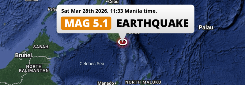
In the Philippine Sea 71 kilometer from General Santos, The Philippines, a significant Magnitude 5.1 earthquake occurred around noon of Saturday March 28th, 2026.
Felt the earthquake? Share this article: 


Earthquake Summary
This earthquake hit under water in the Philippine Sea, right off the coast of The Philippines (9 mi offshore), 71 kilometer south-east of General Santos in Soccsksargen. The center of this earthquake had an intermediate depth of 203 km.
| Date and Time: | Mar 28, 2026 11:33AM (Manila Time) - Mar 28, 2026 03:33 Universal Time. |
|---|---|
| Location: | 71 km SE of General Santos, Soccsksargen, The Philippines. Coordinates 5°38'6"N 125°35'57"E. |
| Map: | 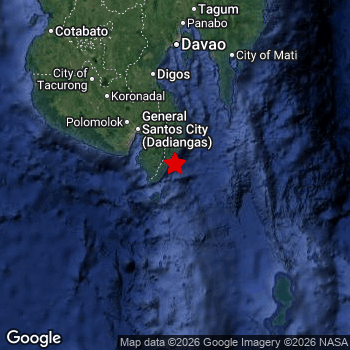 Map of area around epicenter. Click to open in Google Maps. |
| Magnitude: | MAG 5.1 Detected by 51 stations. Maximum Error Range ±0.081 . |
| Depth: | 203 km (126 mi) An intermediate depth. |
| Tsunami Risk: | Tsunami very unlikely Earthquakes under MAG-6.5 at depths deeper than 100km are very unlikely to cause tsunami's. Always stay cautious - More info here. |
Nearby towns and cities
This earthquake may have been felt in The Philippines . The closest significant population center near the earthquake is Glan in Soccsksargen, The Philippines. Glan is located 49 kilometer (30 mi) south-east of the epicenter.
Major cities near this earthquake: General Santos is located 71 km to the northwest. Davao is located 160 km to the north. Budta is located 216 km to the northwest.
A complete list of nearby places is included below.
Overview of nearby places
| Distance | Place |
|---|---|
| 49 km (30 mi) NW from epicenter |
Glan Soccsksargen, The Philippines. |
| 51 km (32 mi) NW from epicenter |
Malapatan Soccsksargen, The Philippines. |
| 62 km (39 mi) NW from epicenter |
Alabel Soccsksargen, The Philippines. |
| 71 km (44 mi) NW from epicenter |
General Santos Soccsksargen, The Philippines. |
| 80 km (50 mi) NW from epicenter |
Maluñgun Soccsksargen, The Philippines. |
| 87 km (54 mi) N from epicenter |
Malita Davao, The Philippines. |
| 88 km (55 mi) NW from epicenter |
Polomolok Soccsksargen, The Philippines. |
| 103 km (64 mi) N from epicenter |
Santa Maria Davao, The Philippines. |
| 106 km (66 mi) NW from epicenter |
Tupi Soccsksargen, The Philippines. |
| 118 km (73 mi) NW from epicenter |
Lake Sebu Soccsksargen, The Philippines. |
| 125 km (78 mi) NW from epicenter |
Surallah Soccsksargen, The Philippines. |
| 126 km (78 mi) NW from epicenter |
Bañga Soccsksargen, The Philippines. |
| 127 km (79 mi) NW from epicenter |
Koronadal Soccsksargen, The Philippines. |
| 127 km (79 mi) N from epicenter |
Digos Davao, The Philippines. |
| 134 km (83 mi) N from epicenter |
Magsaysay Davao, The Philippines. |
| 135 km (84 mi) N from epicenter |
Bansalan Davao, The Philippines. |
| 148 km (92 mi) N from epicenter |
Lupon Davao, The Philippines. |
| 149 km (93 mi) NW from epicenter |
Buluan Rehiyong Autonomo sa Muslim na Mindanao, The Philippines. |
| 156 km (97 mi) NW from epicenter |
Isulan Soccsksargen, The Philippines. |
| 156 km (97 mi) NW from epicenter |
Tacurong Soccsksargen, The Philippines. |
| 160 km (99 mi) N from epicenter |
Davao Davao, The Philippines. |
| 161 km (100 mi) N from epicenter |
Samal Davao, The Philippines. |
| 162 km (101 mi) NE from epicenter |
Mati Davao, The Philippines. |
| 163 km (101 mi) N from epicenter |
Kidapawan Soccsksargen, The Philippines. |
| 166 km (103 mi) NW from epicenter |
Laguilayan Soccsksargen, The Philippines. |
| 184 km (114 mi) NW from epicenter |
Kabacan Soccsksargen, The Philippines. |
| 186 km (116 mi) N from epicenter |
Panabo Davao, The Philippines. |
| 187 km (116 mi) NW from epicenter |
Maganoy Rehiyong Autonomo sa Muslim na Mindanao, The Philippines. |
| 198 km (123 mi) N from epicenter |
Cabayangan Davao, The Philippines. |
| 203 km (126 mi) N from epicenter |
Magugpo Poblacion Davao, The Philippines. |
| 204 km (127 mi) NE from epicenter |
Manay Davao, The Philippines. |
| 209 km (130 mi) NW from epicenter |
Midsayap Soccsksargen, The Philippines. |
| 210 km (130 mi) NW from epicenter |
Malingao Soccsksargen, The Philippines. |
| 212 km (132 mi) N from epicenter |
San Mariano Davao, The Philippines. |
| 215 km (134 mi) NW from epicenter |
Pagaluñgan Rehiyong Autonomo sa Muslim na Mindanao, The Philippines. |
| 216 km (134 mi) NW from epicenter |
Budta Rehiyong Autonomo sa Muslim na Mindanao, The Philippines. |
| 218 km (135 mi) N from epicenter |
New Corella Davao, The Philippines. |
| 223 km (139 mi) N from epicenter |
Nabunturan Davao, The Philippines. |
| 231 km (144 mi) NW from epicenter |
Cotabato Rehiyong Autonomo sa Muslim na Mindanao, The Philippines. |
| 233 km (145 mi) N from epicenter |
Compostela Davao, The Philippines. |
| 237 km (147 mi) N from epicenter |
Don Carlos Northern Mindanao, The Philippines. |
| 239 km (149 mi) N from epicenter |
Quezon Northern Mindanao, The Philippines. |
| 242 km (150 mi) NW from epicenter |
Parang Rehiyong Autonomo sa Muslim na Mindanao, The Philippines. |
| 246 km (153 mi) N from epicenter |
Maramag Northern Mindanao, The Philippines. |
| 248 km (154 mi) N from epicenter |
Monkayo Davao, The Philippines. |
| 250 km (155 mi) NW from epicenter |
Wao Rehiyong Autonomo sa Muslim na Mindanao, The Philippines. |
| 253 km (157 mi) N from epicenter |
Dologon Northern Mindanao, The Philippines. |
| 259 km (161 mi) N from epicenter |
NIA Valencia Northern Mindanao, The Philippines. |
| 274 km (170 mi) N from epicenter |
Veruela Caraga, The Philippines. |
| 285 km (177 mi) N from epicenter |
Malaybalay Northern Mindanao, The Philippines. |
| 298 km (185 mi) N from epicenter |
Bislig Caraga, The Philippines. |
2 Aftershocks detected
This main shock was followed by 2 smaller aftershocks. At a distance of 26 km (16 mi) north-east of this earthquake, an aftershock struck 2 days later. It measured a magnitude of 4.2
Overview of foreshocks and aftershocks
| Classification | Magnitude | When | Where |
|---|---|---|---|
| Main Shock This Earthquake |
M 5.1 |
Mar 28, 2026 11:33AM (Manila Time) | - |
| Aftershock | M 4.2 |
2 days later Mar 30, 2026 03:07AM (Manila Time) | 26 km (16 mi) NE from Main Shock. |
| Aftershock | M 3.2 |
3 days later Mar 31, 2026 04:15AM (Manila Time) | 95 km (59 mi) SE from Main Shock. |
More earthquakes coming?
Earthquakes can create aftershocks. These are generally at least 1 magnitude lower than any main shock, and as time passes the chance and strength of aftershocks decreases.
It's always adviced to be cautious of the risk of a larger shock following any significant earthquake, however this risk is fairly small. There is a roughly 94 percent change that no larger main shock will follow in the days following this earthquake.
Read: How to Stay Safe during an Earthquake (cdc.gov).Earthquakes like this happen often in the region
Earthquakes of this strength are very common in the region. This is the strongest earthquake to hit since February 28th, 2026, when a 5.3 magnitude earthquake hit 78 km (48 mi) further south-east. An even stronger magnitude 7.4 earthquake struck on October 10th, 2025.
In total, 196 earthquakes with a magnitude of 5.1 or higher have been registered within 300km (186 mi) of this epicenter in the past 10 years. This comes down to an average of once every 19 days.
Tsunami very unlikely
For a serious tsunami to occur, earthquakes usually need to have a magnitude of at least 6.5 and occur at a shallow depth of maximum 100km. Neither are the case with this earthquake. However always stay cautious and monitor advice from local authorities.
Tsunami Risk Factors
| Factor | Under Sea? | MAG-6.5 or stronger? | Shallow depth? |
|---|---|---|---|
| Explanation | Almost all tsunami's are caused by earthquakes with their epicenter under sea or very near the sea. However stay cautious in coastal areas as earthquakes on land may cause landslides into sea, potentially still causing a local tsunami. | Under MAG 6.5: Very unlikely to cause a tsunami. MAG 6.5 to 7.5: Destructive tsunami's do occur, but are uncommon. Likely to observe small sea level changes. MAG 7.6+: Earthquakes with these magnitudes might produce destructive tsunami's. |
Most destructive tsunami's are caused by shallow earthquakes with a depth between 0 and 100km under the surface of the earth. Deeper tsunami's are unlikely to displace to ocean floor. |
| This Earthquake | This earthquake appears to have struck under the sea. | Not this earthquake. This earthquake had a magnitude of 5.1. Earthquakes of this strength are unlikely to trigger a tsunami. |
Not this earthquake. This earthquake occurred at a depth of 203 km (126 mi). Earthquakes this deep in the earth are unlikely to trigger a tsunami. |
Sources
Last updated 01/04/26 02:38 (). This article is automatically generated based on available data. We keep checking multiple sources for additional information. This article gets updated as new details on this earthquake become available.
- US Geographic Society (USGS): Earthquake us7000s8ay
- European-Mediterranean Seismological Centre (EMSC): Earthquake 20260328_0000035
- Geonames.org: World Cities Database
- Google Maps: Static API
- Earthquakelist.org: Historic Earthquakes Database
Share this article:
