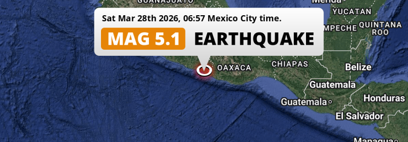
A shallow and significant M5.1 earthquake struck in the North Pacific Ocean 46 kilometer from Ometepec, Mexico in the early morning of Saturday March 28th, 2026.
Felt the earthquake? Share this article: 


Earthquake Summary
This earthquake hit under water in the North Pacific Ocean, right off the coast of Mexico (3 mi offshore), 46 kilometer southwest of Ometepec in Guerrero. The center of this earthquake had a very shallow depth of 10 km. Shallow earthquakes usually have a larger impact than earthquakes deep in the earth.
| Date and Time: | Mar 28, 2026 06:57 (Mexico City Time) - Mar 28, 2026 12:57 Universal Time. |
|---|---|
| Location: | 46 km SW of Ometepec, Guerrero, Mexico. Coordinates 16°20'30"N 98°37'57"W. |
| Map: | 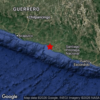 Map of area around epicenter. Click to open in Google Maps. |
| Magnitude: | MAG 5.1 Detected by 34 stations. Maximum Error Range ±0.053 . |
| Depth: | 10 km (6 mi) A very shallow depth. |
| Tsunami Risk: | Low tsunami risk Earthquakes under MAG-6.5 do not usually cause tsunami's. Always stay cautious - More info here. |
Nearby towns and cities
This earthquake may have been felt in Mexico . Located 46 kilometer (29 mi) southwest of the epicenter of this earthquake, Ometepec (Guerrero, Mexico) is the nearest significant population center.
Multiple large cities are in proximity of today's earthquake. Acapulco de Juárez is located 147 km to the west. Oaxaca is located 219 km to the east. Cuernavaca is located 294 km to the north.
The table below provides an overview of all places in proximity of today's earthquake.
Overview of nearby places
| Distance | Place |
|---|---|
| 46 km (29 mi) NE from epicenter |
Ometepec Guerrero, Mexico. |
| 62 km (39 mi) E from epicenter |
Pinotepa Nacional Oaxaca, Mexico. |
| 85 km (53 mi) NW from epicenter |
Ayutla de los Libres Guerrero, Mexico. |
| 134 km (83 mi) N from epicenter |
Tlapa de Comonfort Guerrero, Mexico. |
| 145 km (90 mi) NE from epicenter |
Heroica Ciudad de Tlaxiaco Oaxaca, Mexico. |
| 147 km (91 mi) W from epicenter |
Acapulco de Juárez Guerrero, Mexico. |
| 151 km (94 mi) NW from epicenter |
Chilapa de Álvarez Guerrero, Mexico. |
| 159 km (99 mi) NW from epicenter |
Tixtla de Guerrero Guerrero, Mexico. |
| 163 km (101 mi) NW from epicenter |
Chilpancingo Guerrero, Mexico. |
| 174 km (108 mi) NW from epicenter |
Zumpango del Río Guerrero, Mexico. |
| 174 km (108 mi) E from epicenter |
Puerto Escondido Oaxaca, Mexico. |
| 187 km (116 mi) NE from epicenter |
Ciudad de Huajuapan de León Oaxaca, Mexico. |
| 214 km (133 mi) NW from epicenter |
Atoyac de Álvarez Guerrero, Mexico. |
| 215 km (134 mi) E from epicenter |
Ocotlán de Morelos Oaxaca, Mexico. |
| 215 km (134 mi) NE from epicenter |
Santa María Atzompa Oaxaca, Mexico. |
| 216 km (134 mi) N from epicenter |
Acatlán de Osorio Puebla, Mexico. |
| 216 km (134 mi) E from epicenter |
Santa Cruz Xoxocotlán Oaxaca, Mexico. |
| 217 km (135 mi) E from epicenter |
Miahuatlán de Porfirio Díaz Oaxaca, Mexico. |
| 219 km (136 mi) E from epicenter |
Oaxaca Oaxaca, Mexico. |
| 219 km (136 mi) E from epicenter |
San Antonio de la Cal Oaxaca, Mexico. |
| 230 km (143 mi) N from epicenter |
Ciudad de Huitzuco Guerrero, Mexico. |
| 234 km (145 mi) NW from epicenter |
Técpan de Galeana Guerrero, Mexico. |
| 241 km (150 mi) N from epicenter |
Axochiapan Morelos, Mexico. |
| 243 km (151 mi) NW from epicenter |
Iguala de la Independencia Guerrero, Mexico. |
| 252 km (157 mi) N from epicenter |
Izúcar de Matamoros Puebla, Mexico. |
| 259 km (161 mi) N from epicenter |
Jojutla Morelos, Mexico. |
| 261 km (162 mi) N from epicenter |
Tlaquiltenango Morelos, Mexico. |
| 261 km (162 mi) NW from epicenter |
Teloloapan Guerrero, Mexico. |
| 263 km (163 mi) N from epicenter |
Puente de Ixtla Morelos, Mexico. |
| 264 km (164 mi) N from epicenter |
Zacatepec Morelos, Mexico. |
| 266 km (165 mi) NE from epicenter |
Altepexi Puebla, Mexico. |
| 266 km (165 mi) NE from epicenter |
Zinacatepec Puebla, Mexico. |
| 267 km (166 mi) NW from epicenter |
Taxco de Alarcón Guerrero, Mexico. |
| 268 km (167 mi) N from epicenter |
Xoxocotla Morelos, Mexico. |
| 269 km (167 mi) N from epicenter |
Santa Rosa Treinta Morelos, Mexico. |
| 269 km (167 mi) NE from epicenter |
Ajalpan Puebla, Mexico. |
| 270 km (168 mi) NE from epicenter |
Tehuacán Puebla, Mexico. |
| 274 km (170 mi) E from epicenter |
Crucecita Oaxaca, Mexico. |
| 276 km (171 mi) N from epicenter |
Cuautla Morelos, Mexico. |
| 279 km (173 mi) N from epicenter |
Xochitepec Morelos, Mexico. |
| 281 km (175 mi) NW from epicenter |
Arcelia Guerrero, Mexico. |
| 284 km (176 mi) N from epicenter |
Yecapixtla Morelos, Mexico. |
| 284 km (176 mi) N from epicenter |
Emiliano Zapata Morelos, Mexico. |
| 286 km (178 mi) N from epicenter |
Temixco Morelos, Mexico. |
| 286 km (178 mi) N from epicenter |
Yautepec Morelos, Mexico. |
| 286 km (178 mi) N from epicenter |
Atlixco Puebla, Mexico. |
| 288 km (179 mi) N from epicenter |
Tres de Mayo Morelos, Mexico. |
| 288 km (179 mi) N from epicenter |
Jiutepec Morelos, Mexico. |
| 294 km (183 mi) N from epicenter |
Cuernavaca Morelos, Mexico. |
| 298 km (185 mi) N from epicenter |
Tecamachalco Puebla, Mexico. |
| 299 km (186 mi) N from epicenter |
Ixtapan de la Sal México, Mexico. |
Shaking reported by 2 people
People that feel an earthquake may report their experience to the US Geographic Survey. Currently, 2 people have reported shaking in 2 places in Mexico.We keep updating this article as more ground reports become available. You may report that you felt this earthquake here.
Places with most reports:
- Tlaxiaco, Oaxaca, Mexico: 1 person.
- Tlalnepantla, México, Mexico: 1 person.
17 Aftershocks detected
This main shock was followed by 17 smaller aftershocks. A 4.9 magnitude earthquake hit 2 hrs later 36 km (22 mi) north-east of this earthquake.
Before this earthquake struck, 19 smaller foreshocks occurred. A 4.7 magnitude earthquake hit 29 mins earlier nearby.
Overview of foreshocks and aftershocks
| Classification | Magnitude | When | Where |
|---|---|---|---|
| Foreshock | M 3.0 |
2 days earlier Mar 26, 2026 03:36 (Mexico City Time) | 99 km (62 mi) W from Main Shock. |
| Foreshock | M 4.1 |
2 days earlier Mar 26, 2026 10:39 (Mexico City Time) | 25 km (16 mi) S from Main Shock. |
| Foreshock | M 3.7 |
2 days earlier Mar 26, 2026 12:57 (Mexico City Time) | 28 km (17 mi) S from Main Shock. |
| Foreshock | M 3.8 |
2 days earlier Mar 26, 2026 15:00 (Mexico City Time) | 83 km (52 mi) NW from Main Shock. |
| Foreshock | M 3.4 |
17 hrs earlier Mar 27, 2026 14:05 (Mexico City Time) | 25 km (15 mi) N from Main Shock. |
| Foreshock | M 4.3 |
9 hrs earlier Mar 27, 2026 22:11 (Mexico City Time) | 46 km (29 mi) S from Main Shock. |
| Foreshock | M 4.6 |
9 hrs earlier Mar 27, 2026 22:27 (Mexico City Time) | 45 km (28 mi) NE from Main Shock. |
| Foreshock | M 4.7 |
6 hrs earlier Mar 28, 2026 00:29 (Mexico City Time) | 18 km (11 mi) S from Main Shock. |
| Foreshock | M 4.7 |
6 hrs earlier Mar 28, 2026 00:29 (Mexico City Time) | 26 km (16 mi) NE from Main Shock. |
| Foreshock | M 4.3 |
6 hrs earlier Mar 28, 2026 00:34 (Mexico City Time) | 47 km (29 mi) S from Main Shock. |
| Foreshock | M 4.2 |
5 hrs earlier Mar 28, 2026 01:56 (Mexico City Time) | 36 km (22 mi) S from Main Shock. |
| Foreshock | M 4.4 |
4 hrs earlier Mar 28, 2026 03:00 (Mexico City Time) | 65 km (40 mi) S from Main Shock. |
| Foreshock | M 4.3 |
2 hrs earlier Mar 28, 2026 04:36 (Mexico City Time) | 46 km (29 mi) SE from Main Shock. |
| Foreshock | M 3.8 |
2 hrs earlier Mar 28, 2026 04:38 (Mexico City Time) | 31 km (19 mi) S from Main Shock. |
| Foreshock | M 3.6 |
2 hrs earlier Mar 28, 2026 04:40 (Mexico City Time) | 35 km (22 mi) S from Main Shock. |
| Foreshock | M 3.6 |
2 hrs earlier Mar 28, 2026 04:42 (Mexico City Time) | 33 km (20 mi) S from Main Shock. |
| Foreshock | M 3.9 |
2 hrs earlier Mar 28, 2026 04:46 (Mexico City Time) | 30 km (19 mi) S from Main Shock. |
| Foreshock | M 3.8 |
2 hrs earlier Mar 28, 2026 04:51 (Mexico City Time) | 32 km (20 mi) S from Main Shock. |
| Foreshock | M 4.7 |
29 mins earlier Mar 28, 2026 06:29 (Mexico City Time) | 18 km (11 mi) E from Main Shock. |
| Main Shock This Earthquake |
M 5.1 |
Mar 28, 2026 06:57 (Mexico City Time) | - |
| Aftershock | M 4.9 |
2 hrs later Mar 28, 2026 09:02 (Mexico City Time) | 36 km (22 mi) NE from Main Shock. |
| Aftershock | M 3.0 |
7 hrs later Mar 28, 2026 13:59 (Mexico City Time) | 96 km (59 mi) NW from Main Shock. |
| Aftershock | M 4.2 |
16 hrs later Mar 28, 2026 22:53 (Mexico City Time) | 33 km (20 mi) E from Main Shock. |
| Aftershock | M 3.1 |
22 hrs later Mar 29, 2026 04:37 (Mexico City Time) | 69 km (43 mi) E from Main Shock. |
| Aftershock | M 4.0 |
1 day later Mar 29, 2026 08:36 (Mexico City Time) | 29 km (18 mi) S from Main Shock. |
| Aftershock | M 4.0 |
1 day later Mar 29, 2026 09:00 (Mexico City Time) | 38 km (24 mi) S from Main Shock. |
| Aftershock | M 3.5 |
1 day later Mar 29, 2026 14:06 (Mexico City Time) | 51 km (32 mi) NE from Main Shock. |
| Aftershock | M 3.6 |
1 day later Mar 29, 2026 14:23 (Mexico City Time) | 76 km (47 mi) W from Main Shock. |
| Aftershock | M 3.6 |
1 day later Mar 29, 2026 14:51 (Mexico City Time) | 86 km (53 mi) NW from Main Shock. |
| Aftershock | M 3.3 |
1 day later Mar 29, 2026 15:33 (Mexico City Time) | 29 km (18 mi) S from Main Shock. |
| Aftershock | M 3.2 |
2 days later Mar 30, 2026 00:50 (Mexico City Time) | 99 km (61 mi) NW from Main Shock. |
| Aftershock | M 3.5 |
2 days later Mar 30, 2026 00:58 (Mexico City Time) | 73 km (45 mi) NW from Main Shock. |
| Aftershock | M 3.0 |
2 days later Mar 30, 2026 01:06 (Mexico City Time) | 29 km (18 mi) E from Main Shock. |
| Aftershock | M 3.6 |
2 days later Mar 30, 2026 01:20 (Mexico City Time) | 29 km (18 mi) NE from Main Shock. |
| Aftershock | M 3.8 |
2 days later Mar 30, 2026 03:39 (Mexico City Time) | 75 km (47 mi) W from Main Shock. |
| Aftershock | M 3.9 |
2 days later Mar 30, 2026 13:22 (Mexico City Time) | 42 km (26 mi) SW from Main Shock. |
| Aftershock | M 3.4 |
2 days later Mar 30, 2026 13:53 (Mexico City Time) | 97 km (60 mi) NW from Main Shock. |
More earthquakes coming?
Aftershocks are usually at least 1 order of magnitude less strong than main shocks. The more time passes, the smaller the chance and likely strength of any potential aftershocks.
In only six percent of cases, significant earthquakes are followed by a larger main shock, making the current earthquake a foreshock. While the chance of this happening is not so large, it is adviced to maintain cautiousness in the hours and days following a major earthquake.
Read: How to Stay Safe during an Earthquake (cdc.gov).Earthquakes like this happen often in the region
Earthquakes of this strength are very common in the region. This is the strongest earthquake to hit since February 8th, 2026, when a 5.7 magnitude earthquake hit 211 km (131 mi) further east. An even stronger magnitude 7.4 earthquake struck on June 23rd, 2020.
In total, 37 earthquakes with a magnitude of 5.1 or higher have been registered within 300km (186 mi) of this epicenter in the past 10 years. This comes down to an average of once every 3 months.
Low tsunami risk
Based on early data it appears this earthquake was not strong enough (lower than MAG-6.5) to be likely to cause destructive tsunami's. However this earthquake appeared to have hit at a shallow depth under sea, so stay cautious and monitor advice from local authorities.
Tsunami Risk Factors
| Factor | Under Sea? | MAG-6.5 or stronger? | Shallow depth? |
|---|---|---|---|
| Explanation | Almost all tsunami's are caused by earthquakes with their epicenter under sea or very near the sea. However stay cautious in coastal areas as earthquakes on land may cause landslides into sea, potentially still causing a local tsunami. | Under MAG 6.5: Very unlikely to cause a tsunami. MAG 6.5 to 7.5: Destructive tsunami's do occur, but are uncommon. Likely to observe small sea level changes. MAG 7.6+: Earthquakes with these magnitudes might produce destructive tsunami's. |
Most destructive tsunami's are caused by shallow earthquakes with a depth between 0 and 100km under the surface of the earth. Deeper tsunami's are unlikely to displace to ocean floor. |
| This Earthquake | This earthquake appears to have struck under the sea. | Not this earthquake. This earthquake had a magnitude of 5.1. Earthquakes of this strength are unlikely to trigger a tsunami. |
This earthquake occurred at a depth of of 10 km (6 mi). Earthquakes this shallow could trigger a tsunami. |
Sources
Last updated 31/03/26 12:28 (). This article is automatically generated based on available data. We keep checking multiple sources for additional information. This article gets updated as new details on this earthquake become available.
- US Geographic Society (USGS): Earthquake us7000s8d7
- European-Mediterranean Seismological Centre (EMSC): Earthquake 20260328_0000169
- Geonames.org: World Cities Database
- Google Maps: Static API
- Earthquakelist.org: Historic Earthquakes Database
Share this article:
