In the early afternoon of Saturday March 28th, 2026, a shallow and significant MAG-5.4 earthquake hit in the South Pacific Ocean 243 kilometer from Apia, Samoa. Shaking may have been felt by a total of 40 thousand people. Another nearby country is American Samoa.
Felt the earthquake? Share this article: 


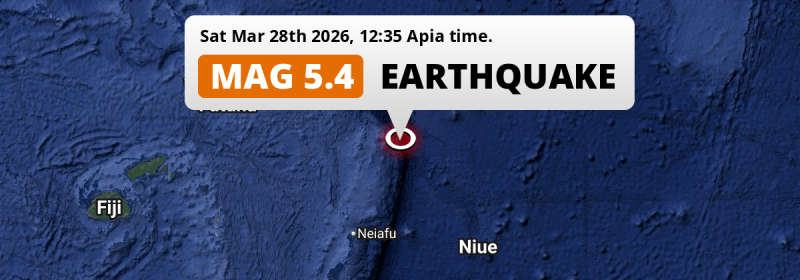
Earthquake Summary
This earthquake hit under water in the South Pacific Ocean, 220 kilometers (137 mi) off the coast of Samoa, 243 kilometer south of Apia in Tuamasaga. The center of this earthquake had a very shallow depth of 10 km. Shallow earthquakes usually have a larger impact than earthquakes deep in the earth.
| Date and Time: | Mar 28, 2026 12:35 (Apia Time) - Mar 27, 2026 23:35 Universal Time. |
|---|---|
| Location: | 243 km south of Apia, Tuamasaga, Samoa. Coordinates 15°55'15"S 172°26'19"W. |
| Map: | 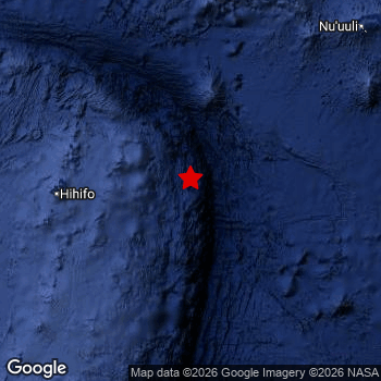 Map of area around epicenter. Click to open in Google Maps. |
| Magnitude: | MAG 5.4 Detected by 8 stations. Maximum Error Range ±0.11 . |
| Depth: | 10 km (6 mi) A very shallow depth. |
| Max. Intensity: | IV
Light On the Modified Mercalli Scale. |
| Tsunami Risk: | Low tsunami risk Earthquakes under MAG-6.5 do not usually cause tsunami's. Always stay cautious - More info here. |
Minimal impact predicted
Based on scientific estimates by the US Geographic Survey (USGS), the risk of high fatalities for this earthquake is classified at level GREEN (low). They expect an 90% likelyhood of between 0 and 1 fatalities.
The USGS classifies the economic impact of this earthquake at level GREEN (low). They expect an 90% likelyhood of between 0 and 1 million US Dollars in economic damage and impact.
Roughly 40 thousand people exposed to shaking
An estimated 40 thousand have been exposed to shaking (An MMI or Modified Mercalli Intensity level II or higher) as a result of this earthquake according scientific estimates published by the USGS.
The highest earthquake impact level for this earthquake is II, which corresponds with very weak shaking and no damage. Roughly 42,370 people are expected to be exposed to this level.
People in 2 countries have been exposed to shaking. Roughly 40 thousand people were exposed to shaking in American Samoa , with level II (very weak shaking, no damage) as the highest recorded.
| People | MMI Level | Shaking | Damage |
|---|---|---|---|
| 0 | I |
Not noticable | None |
| 42,370 | II |
Very weak | None |
| 0 | III |
Weak | Probably none |
| 0 | IV |
Light | Likely none |
| 0 | V |
Moderate | Very light |
| 0 | VI |
Strong | Light |
| 0 | VII |
Very Strong | Moderate |
| 0 | VIII |
Severe | Moderate to heavy |
| 0 | IX |
Violent | Heavy |
| 0 | X |
Extreme | Very heavy |
Nearby towns and cities
2 countries can be found within 300km of the epicenter of this earthquake: Samoa and American Samoa .
Located 243 kilometer (151 mi) south of the epicenter of this earthquake, Apia (Tuamasaga, Samoa) is the nearest significant population center.
Overview of nearby places
| Distance | Place | Intensity (MMI) |
|---|---|---|
| 243 km (151 mi) N from epicenter |
Apia Tuamasaga, Samoa. |
|
| 261 km (162 mi) NE from epicenter |
Pago Pago Eastern District, American Samoa. |
II
Weak |
Earthquake Intensity Map
The graph below overlays a map of the region around the epicenter with earthquake intensity data provided by the US Geographic Survey. The highest intensity level detected for this earthquake is III.

4 Aftershocks detected
Since this main shock, 4 smaller aftershocks were detected. Just 24 hrs after this main shock, an earthquake measuring MAG-4.6 was detected 83 km (52 mi) northwest of this earthquake.
Overview of foreshocks and aftershocks
| Classification | Magnitude | When | Where |
|---|---|---|---|
| Main Shock This Earthquake |
M 5.4 |
Mar 28, 2026 12:35 (Apia Time) | - |
| Aftershock | M 4.5 |
2 hrs later Mar 28, 2026 14:15 (Apia Time) | 68 km (42 mi) W from Main Shock. |
| Aftershock | M 4.5 |
3 hrs later Mar 28, 2026 15:18 (Apia Time) | 76 km (47 mi) W from Main Shock. |
| Aftershock | M 4.6 |
24 hrs later Mar 29, 2026 12:30 (Apia Time) | 83 km (52 mi) NW from Main Shock. |
| Aftershock | M 4.6 |
24 hrs later Mar 29, 2026 12:30 (Apia Time) | 83 km (52 mi) NW from Main Shock. |
More earthquakes coming?
Earthquakes can create aftershocks. These are generally at least 1 magnitude lower than any main shock, and as time passes the chance and strength of aftershocks decreases.
In only six percent of cases, significant earthquakes are followed by a larger main shock, making the current earthquake a foreshock. While the chance of this happening is not so large, it is adviced to maintain cautiousness in the hours and days following a major earthquake.
Read: How to Stay Safe during an Earthquake (cdc.gov).Earthquakes like this happen often in the region
Earthquakes of this strength are very common in the region. This is the strongest earthquake to hit since March 25th, 2026, when a 5.6 magnitude earthquake hit 229 km (142 mi) further west. An even stronger magnitude 7.6 earthquake struck on May 10th, 2023.
In total, 107 earthquakes with a magnitude of 5.4 or higher have been registered within 300km (186 mi) of this epicenter in the past 10 years. This comes down to an average of once every month.
Low tsunami risk
Based on early data it appears this earthquake was not strong enough (lower than MAG-6.5) to be likely to cause destructive tsunami's. However this earthquake appeared to have hit at a shallow depth under sea, so stay cautious and monitor advice from local authorities.
Tsunami Risk Factors
| Factor | Under Sea? | MAG-6.5 or stronger? | Shallow depth? |
|---|---|---|---|
| Explanation | Almost all tsunami's are caused by earthquakes with their epicenter under sea or very near the sea. However stay cautious in coastal areas as earthquakes on land may cause landslides into sea, potentially still causing a local tsunami. | Under MAG 6.5: Very unlikely to cause a tsunami. MAG 6.5 to 7.5: Destructive tsunami's do occur, but are uncommon. Likely to observe small sea level changes. MAG 7.6+: Earthquakes with these magnitudes might produce destructive tsunami's. |
Most destructive tsunami's are caused by shallow earthquakes with a depth between 0 and 100km under the surface of the earth. Deeper tsunami's are unlikely to displace to ocean floor. |
| This Earthquake | This earthquake appears to have struck under the sea. | Not this earthquake. This earthquake had a magnitude of 5.4. Earthquakes of this strength are unlikely to trigger a tsunami. |
This earthquake occurred at a depth of of 10 km (6 mi). Earthquakes this shallow could trigger a tsunami. |
Sources
Last updated 18/04/26 01:38 (). This article contains currently available information about the earthquake and is automatically composed. We continue to update this article up to a few days after the earthquake occurred.
- US Geographic Society (USGS): Earthquake us7000s8a0
- European-Mediterranean Seismological Centre (EMSC): Earthquake 20260327_0000394
- Geonames.org: World Cities Database
- Google Maps: Static API
- Earthquakelist.org: Historic Earthquakes Database
Share this article:
