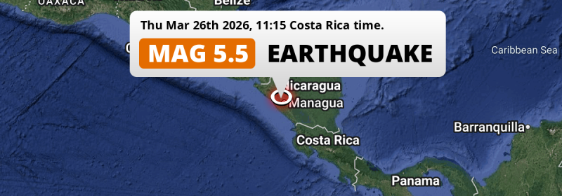
In the morning of Thursday March 26th, 2026, a significant Magnitude 5.5 earthquake hit under land 15 kilometer from Managua in Nicaragua. Around 8 million people have been exposed to shaking. Honduras, Costa Rica and El Salvador are also near its epicenter.
Felt the earthquake? Share this article: 


Earthquake Summary
The earthquake struck on land in Nicaragua, 15 kilometer (9 mi) west of Managua. The center of this earthquake had an intermediate depth of 156 km.
| Date and Time: | Mar 26, 2026 11:15AM (Managua Time) - Mar 26, 2026 17:15 Universal Time. |
|---|---|
| Location: | 15 km west of Managua, Nicaragua. Coordinates 12°6'41"N 86°23'17"W. |
| Map: | 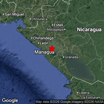 Map of area around epicenter. Click to open in Google Maps. |
| Magnitude: | MAG 5.5 Detected by 45 stations. Maximum Error Range ±0.046 . |
| Depth: | 156 km (97 mi) An intermediate depth. |
| Max. Intensity: | IV
Light On the Modified Mercalli Scale. |
| Tsunami Risk: | Tsunami very unlikely Tsunami's are usually caused by MAG-6.5+ earthquakes, less than 100km shallow, and with an epicenter under sea. Neither of this seems to be the case. Always stay cautious - More info here. |
Minimal impact predicted
Based on scientific estimates by the US Geographic Survey (USGS), the risk of high fatalities for this earthquake is classified at level GREEN (low). They expect an 90% likelyhood of between 0 and 1 fatalities.
The USGS classifies the economic impact of this earthquake at level GREEN (low). They expect an 90% likelyhood of between 0 and 1 million US Dollars in economic damage and impact.
Roughly 8 million people exposed to shaking
The USGS has published a report estimating the number of people exposed to this earthquake. Acoording to their analysis, roughly 8 million have been exposed to shaking at an MMI level of II or higher.
An estimated 536,600 people were exposed to level IV. At this level, light shaking and likely no damage can be expected. Intensity level III was experienced by the majority of people (around 7.1 million). In their region, weak shaking and probably no damage can be expected.
People in 4 countries have been exposed to shaking. In Nicaragua , around 6.1 million people, with impact levels up to IV (light shaking, likely no damage). In Honduras , around 0.8 million people. Roughly 650 thousand people were exposed to shaking in El Salvador . In Costa Rica, shaking was experienced too.
| People | MMI Level | Shaking | Damage |
|---|---|---|---|
| 0 | I |
Not noticable | None |
| 431,700 | II |
Very weak | None |
| 7,064,000 | III |
Weak | Probably none |
| 536,600 | IV |
Light | Likely none |
| 0 | V |
Moderate | Very light |
| 0 | VI |
Strong | Light |
| 0 | VII |
Very Strong | Moderate |
| 0 | VIII |
Severe | Moderate to heavy |
| 0 | IX |
Violent | Heavy |
| 0 | X |
Extreme | Very heavy |
Nearby towns and cities
This earthquake struck within proximity of multiple countries. Nicaragua , Honduras , Costa Rica and El Salvador are all within 300km distance of its epicenter.
Located 7 kilometer (4 mi) southwest of the epicenter of this earthquake, Ciudad Sandino (Managua, Nicaragua) is the nearest significant population center. Ciudad Sandino experienced an earthquake intensity (MMI Scale) of roughly IV. That level implies light shaking and likely no damage.
Multiple large cities are in proximity of today's earthquake. Managua is located 15 km to the east and experienced an intensity of III (weak shaking, probably no damage). Masaya is located 35 km to the south-east and experienced an intensity of IV (light shaking, likely no damage). Tegucigalpa is located 236 km to the northwest (intensity unknown, possibly low).
The table below provides an overview of all places in proximity of today's earthquake. Where available, the estimated intensity on the Modified Mercalli Intensity Scale in each place is included. Places where this information is omitted likely experienced little impact.
Overview of nearby places
| Distance | Place | Intensity (MMI) |
|---|---|---|
| 7 km (4 mi) NE from epicenter |
Ciudad Sandino Managua, Nicaragua. |
IV
Light |
| 15 km (9 mi) E from epicenter |
Managua Managua, Nicaragua. |
III
Weak |
| 16 km (10 mi) SE from epicenter |
El Crucero Managua, Nicaragua. |
III
Weak |
| 26 km (16 mi) NW from epicenter |
Nagarote León, Nicaragua. |
IV
Light |
| 30 km (19 mi) S from epicenter |
San Rafael del Sur Managua, Nicaragua. |
IV
Light |
| 30 km (19 mi) SE from epicenter |
San Marcos Carazo, Nicaragua. |
III
Weak |
| 32 km (20 mi) SE from epicenter |
Diriamba Carazo, Nicaragua. |
III
Weak |
| 33 km (21 mi) E from epicenter |
Tipitapa Managua, Nicaragua. |
IV
Light |
| 34 km (21 mi) SE from epicenter |
Masatepe Masaya, Nicaragua. |
III
Weak |
| 35 km (22 mi) SE from epicenter |
Masaya Masaya, Nicaragua. |
IV
Light |
| 36 km (22 mi) SE from epicenter |
Jinotepe Carazo, Nicaragua. |
III
Weak |
| 40 km (25 mi) NW from epicenter |
La Paz Centro León, Nicaragua. |
IV
Light |
| 51 km (32 mi) SE from epicenter |
Granada Granada, Nicaragua. |
III
Weak |
| 54 km (34 mi) SE from epicenter |
Nandaime Granada, Nicaragua. |
III
Weak |
| 64 km (40 mi) NW from epicenter |
León León, Nicaragua. |
III
Weak |
| 87 km (54 mi) NW from epicenter |
Chichigalpa Chinandega, Nicaragua. |
III
Weak |
| 89 km (55 mi) NE from epicenter |
Boaco Boaco, Nicaragua. |
III
Weak |
| 95 km (59 mi) NW from epicenter |
Corinto Chinandega, Nicaragua. |
IV
Light |
| 97 km (60 mi) SE from epicenter |
Rivas Rivas, Nicaragua. |
III
Weak |
| 99 km (62 mi) NW from epicenter |
Chinandega Chinandega, Nicaragua. |
III
Weak |
| 100 km (62 mi) E from epicenter |
Camoapa Boaco, Nicaragua. |
III
Weak |
| 104 km (65 mi) NE from epicenter |
Matagalpa Matagalpa, Nicaragua. |
III
Weak |
| 104 km (65 mi) NW from epicenter |
El Viejo Chinandega, Nicaragua. |
III
Weak |
| 109 km (68 mi) N from epicenter |
Estelí Estelí, Nicaragua. |
III
Weak |
| 111 km (69 mi) E from epicenter |
Juigalpa Chontales, Nicaragua. |
III
Weak |
| 117 km (73 mi) N from epicenter |
Jinotega Jinotega, Nicaragua. |
III
Weak |
| 118 km (73 mi) NW from epicenter |
Somotillo Chinandega, Nicaragua. |
III
Weak |
| 154 km (96 mi) N from epicenter |
Somoto Madriz, Nicaragua. |
III
Weak |
| 156 km (97 mi) NE from epicenter |
Río Blanco Matagalpa, Nicaragua. |
III
Weak |
| 158 km (98 mi) NW from epicenter |
Ciudad Choluteca Choluteca, Honduras. |
III
Weak |
| 169 km (105 mi) N from epicenter |
Ocotal Nueva Segovia, Nicaragua. |
III
Weak |
| 186 km (116 mi) NW from epicenter |
San Lorenzo Valle, Honduras. |
III
Weak |
| 188 km (117 mi) SE from epicenter |
San José Alajuela, Costa Rica. |
III
Weak |
| 194 km (121 mi) SE from epicenter |
Liberia Guanacaste, Costa Rica. |
III
Weak |
| 196 km (122 mi) N from epicenter |
El Paraíso El Paraíso, Honduras. |
III
Weak |
| 203 km (126 mi) N from epicenter |
Jalapa Nueva Segovia, Nicaragua. |
|
| 209 km (130 mi) NW from epicenter |
La Unión La Unión, El Salvador. |
III
Weak |
| 215 km (134 mi) E from epicenter |
Nueva Guinea South Caribbean Coast, Nicaragua. |
|
| 215 km (134 mi) N from epicenter |
Danlí El Paraíso, Honduras. |
|
| 234 km (145 mi) SE from epicenter |
Cañas Guanacaste, Costa Rica. |
III
Weak |
| 236 km (147 mi) NW from epicenter |
Tegucigalpa Francisco Morazán, Honduras. |
|
| 236 km (147 mi) E from epicenter |
Rama South Caribbean Coast, Nicaragua. |
|
| 247 km (153 mi) NW from epicenter |
San Miguel San Miguel, El Salvador. |
III
Weak |
| 251 km (156 mi) NE from epicenter |
Siuna North Caribbean Coast, Nicaragua. |
III
Weak |
| 255 km (158 mi) NW from epicenter |
San Rafael Oriente San Miguel, El Salvador. |
|
| 256 km (159 mi) NW from epicenter |
San Francisco Morazán, El Salvador. |
II
Weak |
| 263 km (163 mi) NW from epicenter |
Usulután Usulután, El Salvador. |
|
| 283 km (176 mi) NW from epicenter |
La Paz La Paz, Honduras. |
|
| 285 km (177 mi) N from epicenter |
Juticalpa Olancho, Honduras. |
|
| 286 km (178 mi) E from epicenter |
Bluefields South Caribbean Coast, Nicaragua. |
|
| 291 km (181 mi) SE from epicenter |
Puntarenas Puntarenas, Costa Rica. |
|
| 291 km (181 mi) SE from epicenter |
Quesada Alajuela, Costa Rica. |
|
| 293 km (182 mi) NW from epicenter |
Comayagua Comayagua, Honduras. |
|
| 295 km (183 mi) SE from epicenter |
Chacarita Puntarenas, Costa Rica. |
Earthquake Intensity Map
The maximum intensity (MMI Scale) caused by this earthquake is IV. The map below shows in which areas this earthquake was the most and least impactful. It is based on data from the US Geographic Survey.

Shaking reported by 6 people in 2 countries
People that feel an earthquake may report their experience to the US Geographic Survey. Currently, 6 people have reported shaking in 5 places in 2 countries (Nicaragua, Costa Rica).We keep updating this article as more ground reports become available. You may report that you felt this earthquake here.
Places with most reports:
- Sámara, Guanacaste, Costa Rica: 2 people.
- Tola, Rivas, Nicaragua: 1 person.
- Managua, Managua, Nicaragua: 1 person.
- San Juan del Sur, Rivas, Nicaragua: 1 person.
- Bagaces, Guanacaste, Costa Rica: 1 person.
2 Aftershocks detected
This main shock was followed by 2 smaller aftershocks. Just 2 hrs after this main shock, an earthquake measuring MAG-3.2 was detected 87 km (54 mi) west of this earthquake.
In the days before this main shock, 1 smaller foreshock was detected. A 2.5 magnitude earthquake hit 13 hrs earlier nearby.
Overview of foreshocks and aftershocks
| Classification | Magnitude | When | Where |
|---|---|---|---|
| Foreshock | M 2.5 |
13 hrs earlier Mar 25, 2026 09:53PM (Managua Time) | 57 km (35 mi) S from Main Shock. |
| Main Shock This Earthquake |
M 5.5 |
Mar 26, 2026 11:15AM (Managua Time) | - |
| Aftershock | M 3.2 |
2 hrs later Mar 26, 2026 01:23PM (Managua Time) | 87 km (54 mi) W from Main Shock. |
| Aftershock | M 3.0 |
2 days later Mar 28, 2026 01:37PM (Managua Time) | 63 km (39 mi) SE from Main Shock. |
More earthquakes coming?
Aftershocks are usually at least 1 order of magnitude less strong than main shocks. The more time passes, the smaller the chance and likely strength of any potential aftershocks.
It's always adviced to be cautious of the risk of a larger shock following any significant earthquake, however this risk is fairly small. There is a roughly 94 percent change that no larger main shock will follow in the days following this earthquake.
Read: How to Stay Safe during an Earthquake (cdc.gov).Earthquakes like this happen often in the region
Earthquakes of this strength are very common in the region. This is the strongest earthquake to hit since December 9th, 2024, when a 5.6 magnitude earthquake hit 206 km (128 mi) further northwest. An even stronger magnitude 6.9 earthquake struck on November 24th, 2016.
In total, 26 earthquakes with a magnitude of 5.5 or higher have been registered within 300km (186 mi) of this epicenter in the past 10 years. This comes down to an average of once every 5 months.
Tsunami very unlikely
It is very unlikely that this eartquake will cause any tsunami's. The reported magnitude is lower than the MAG-6.5 strength required to cause any earthquakes. In addition, this earthquake was not very shallow and appears to have occurred under land. However always stay cautious and monitor advice from local authorities.
Tsunami Risk Factors
| Factor | Under Sea? | MAG-6.5 or stronger? | Shallow depth? |
|---|---|---|---|
| Explanation | Almost all tsunami's are caused by earthquakes with their epicenter under sea or very near the sea. However stay cautious in coastal areas as earthquakes on land may cause landslides into sea, potentially still causing a local tsunami. | Under MAG 6.5: Very unlikely to cause a tsunami. MAG 6.5 to 7.5: Destructive tsunami's do occur, but are uncommon. Likely to observe small sea level changes. MAG 7.6+: Earthquakes with these magnitudes might produce destructive tsunami's. |
Most destructive tsunami's are caused by shallow earthquakes with a depth between 0 and 100km under the surface of the earth. Deeper tsunami's are unlikely to displace to ocean floor. |
| This Earthquake | Not this earthquake. This earthquake appears to have struck on land far from any coast. |
Not this earthquake. This earthquake had a magnitude of 5.5. Earthquakes of this strength are unlikely to trigger a tsunami. |
Not this earthquake. This earthquake occurred at a depth of 156 km (97 mi). Earthquakes this deep in the earth are unlikely to trigger a tsunami. |
Sources
Last updated 31/03/26 16:48 (). As more information on this earthquake becomes available this article will be updated. This article is automatically composed based on data originating from multiple sources.
- US Geographic Society (USGS): Earthquake us7000s7w6
- European-Mediterranean Seismological Centre (EMSC): Earthquake 20260326_0000295
- Geonames.org: World Cities Database
- Google Maps: Static API
- Earthquakelist.org: Historic Earthquakes Database
Share this article:
