34 miles from China, a shallow and significant MAG-5.3 earthquake occurred in the night of Friday March 27th, 2026. Other nearby countries are Pakistan and Tajikistan.
Felt the earthquake? Share this article: 


Earthquake Summary
This earthquake struck 34 miles (54 km) from China The center of this earthquake had a very shallow depth of 10 km. Shallow earthquakes usually have a larger impact than earthquakes deep in the earth.
| Date and Time: | Mar 27, 2026 02:02 (Karachi Time) - Mar 26, 2026 21:02 Universal Time. |
|---|---|
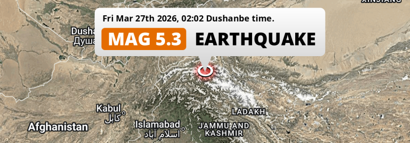
| Location: | 276 km north of Srinagar, Jammu and Kashmir, India. Coordinates 36°33'18"N 74°27'13"E. |
| Map: |  Map of area around epicenter. Click to open in Google Maps. |
| Magnitude: | MAG 5.3 Detected by 201 stations. Maximum Error Range ±0.041 . |
| Depth: | 10 km (6 mi) A very shallow depth. |
| Tsunami Risk: | Low tsunami risk Earthquakes under MAG-6.5 do not usually cause tsunami's. Always stay cautious - More info here. |
Nearby towns and cities
This earthquake struck within proximity of multiple countries. Pakistan , China and Tajikistan are all within 300km distance of its epicenter. Futher away, this earthquake may also have been felt in India.
The closest significant population center near the earthquake is Thal in Khyber Pakhtunkhwa, Pakistan. Thal is located 232 kilometer (144 mi) north-east of the epicenter.
Multiple large cities are in proximity of today's earthquake. Srinagar is located 276 km to the south. Battagram is located 246 km to the southwest. Muzaffarābād is located 259 km to the south.
The table below provides an overview of all places in proximity of today's earthquake.
Overview of nearby places
| Distance | Place |
|---|---|
| 232 km (144 mi) SW from epicenter |
Thal Khyber Pakhtunkhwa, Pakistan. |
| 238 km (148 mi) S from epicenter |
Bandipura Jammu and Kashmir, India. |
| 246 km (153 mi) NE from epicenter |
Huoshilafu Xinjiang, China. |
| 246 km (153 mi) SW from epicenter |
Battagram Khyber Pakhtunkhwa, Pakistan. |
| 252 km (157 mi) S from epicenter |
Sopur Jammu and Kashmir, India. |
| 254 km (158 mi) W from epicenter |
Ishqoshim Gorno-Badakhshan, Tajikistan. |
| 259 km (161 mi) S from epicenter |
Muzaffarābād Azad Kashmir, Pakistan. |
| 261 km (162 mi) S from epicenter |
Gāndarbal Jammu and Kashmir, India. |
| 261 km (162 mi) S from epicenter |
Bāramūla Jammu and Kashmir, India. |
| 266 km (165 mi) NE from epicenter |
Kaqun Xinjiang, China. |
| 272 km (169 mi) SW from epicenter |
Mansehra Khyber Pakhtunkhwa, Pakistan. |
| 273 km (170 mi) SW from epicenter |
Mingora Khyber Pakhtunkhwa, Pakistan. |
| 276 km (171 mi) SW from epicenter |
Upper Dir Khyber Pakhtunkhwa, Pakistan. |
| 276 km (171 mi) S from epicenter |
Srinagar Jammu and Kashmir, India. |
| 277 km (172 mi) S from epicenter |
Soyībug Jammu and Kashmir, India. |
| 278 km (173 mi) W from epicenter |
Khorugh Gorno-Badakhshan, Tajikistan. |
| 291 km (181 mi) S from epicenter |
Abbottabad Khyber Pakhtunkhwa, Pakistan. |
Shaking reported by 3 people
People that feel an earthquake may report their experience to the US Geographic Survey. Currently, 3 people have reported shaking in 2 places in Pakistan.We keep updating this article as more ground reports become available. You may report that you felt this earthquake here.
Places with most reports:
- Gilgit, Northern Areas, Pakistan: 2 people.
- Hunza, Northern Areas, Pakistan: 1 person.
5 Aftershocks detected
After this earthquake struck, 5 smaller aftershocks occurred. At a distance of 15 km (9 mi) northwest of this earthquake, an aftershock struck 8 hrs later. It measured a magnitude of 5
Overview of foreshocks and aftershocks
| Classification | Magnitude | When | Where |
|---|---|---|---|
| Main Shock This Earthquake |
M 5.3 |
Mar 27, 2026 02:02 (Karachi Time) | - |
| Aftershock | M 4.2 |
28 mins later Mar 27, 2026 02:30 (Karachi Time) | 10 km (6 mi) W from Main Shock. |
| Aftershock | M 4.3 |
2 hrs later Mar 27, 2026 04:21 (Karachi Time) | 41 km (25 mi) N from Main Shock. |
| Aftershock | M 4.3 |
6 hrs later Mar 27, 2026 08:01 (Karachi Time) | 15 km (9 mi) SW from Main Shock. |
| Aftershock | M 5.0 |
8 hrs later Mar 27, 2026 09:40 (Karachi Time) | 10 km (6 mi) N from Main Shock. |
| Aftershock | M 5.0 |
8 hrs later Mar 27, 2026 09:52 (Karachi Time) | 15 km (9 mi) NW from Main Shock. |
More earthquakes coming?
The risk of aftershocks decreases rapidly over time. Usually, aftershocks are at least one order of magnitude lower than a main shock.
It's always adviced to be cautious of the risk of a larger shock following any significant earthquake, however this risk is fairly small. There is a roughly 94 percent change that no larger main shock will follow in the days following this earthquake.
Read: How to Stay Safe during an Earthquake (cdc.gov).Earthquakes like this happen often in the region
Earthquakes of this strength are very common in the region. This is the strongest earthquake to hit since February 25th, 2026, when a 5.4 magnitude earthquake hit 264 km (164 mi) further west. An even stronger magnitude 6.9 earthquake struck on February 23rd, 2023.
In total, 20 earthquakes with a magnitude of 5.3 or higher have been registered within 300km (186 mi) of this epicenter in the past 10 years. This comes down to an average of once every 6 months.
Low tsunami risk
Based on early data it appears this earthquake was not strong enough (lower than MAG-6.5) to be likely to cause destructive tsunami's. However this earthquake appeared to have hit at a shallow depth under sea, so stay cautious and monitor advice from local authorities.
Tsunami Risk Factors
| Factor | Under Sea? | MAG-6.5 or stronger? | Shallow depth? |
|---|---|---|---|
| Explanation | Almost all tsunami's are caused by earthquakes with their epicenter under sea or very near the sea. However stay cautious in coastal areas as earthquakes on land may cause landslides into sea, potentially still causing a local tsunami. | Under MAG 6.5: Very unlikely to cause a tsunami. MAG 6.5 to 7.5: Destructive tsunami's do occur, but are uncommon. Likely to observe small sea level changes. MAG 7.6+: Earthquakes with these magnitudes might produce destructive tsunami's. |
Most destructive tsunami's are caused by shallow earthquakes with a depth between 0 and 100km under the surface of the earth. Deeper tsunami's are unlikely to displace to ocean floor. |
| This Earthquake | This earthquake appears to have struck under the sea. | Not this earthquake. This earthquake had a magnitude of 5.3. Earthquakes of this strength are unlikely to trigger a tsunami. |
This earthquake occurred at a depth of of 10 km (6 mi). Earthquakes this shallow could trigger a tsunami. |
Sources
Last updated 30/03/26 20:08 (). This article contains currently available information about the earthquake and is automatically composed. We continue to update this article up to a few days after the earthquake occurred.
- US Geographic Society (USGS): Earthquake us7000s7xx
- European-Mediterranean Seismological Centre (EMSC): Earthquake 20260326_0000350
- Geonames.org: World Cities Database
- Google Maps: Static API
- Earthquakelist.org: Historic Earthquakes Database
Share this article:
