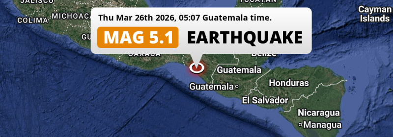
A significant Magnitude 5.1 earthquake struck under land 15 kilometer from Pijijiapan in Mexico in the early morning of Thursday March 26th, 2026. Another country near the epicenter is Guatemala.
Felt the earthquake? Share this article: 


Earthquake Summary
The earthquake struck on land in Mexico, 15 kilometer (9 mi) south of Pijijiapan in Chiapas. The center of this earthquake had an intermediate depth of 112 km.
| Date and Time: | Mar 26, 2026 05:07 (Mexico City Time) - Mar 26, 2026 11:07 Universal Time. |
|---|---|
| Location: | 15 km south of Pijijiapan, Chiapas, Mexico. Coordinates 15°33'6"N 93°10'33"W. |
| Map: | 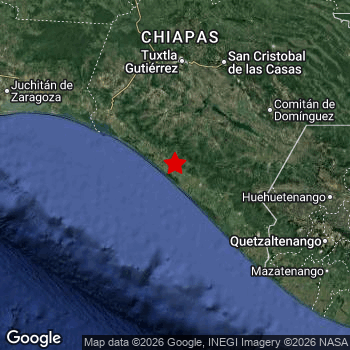 Map of area around epicenter. Click to open in Google Maps. |
| Magnitude: | MAG 5.1 Detected by 508 stations. Maximum Error Range ±0.025 . |
| Depth: | 112 km (70 mi) An intermediate depth. |
| Tsunami Risk: | Tsunami very unlikely Tsunami's are usually caused by MAG-6.5+ earthquakes, less than 100km shallow, and with an epicenter under sea. Neither of this seems to be the case. Always stay cautious - More info here. |
Nearby towns and cities
Mexico and Guatemala are both located within 300km distance of the epicenter of the earthquake.
The closest significant population center near the earthquake is Pijijiapan in Chiapas, Mexico. Pijijiapan is located 15 kilometer (9 mi) south of the epicenter.
Major cities near this earthquake: Tuxtla is located 135 km to the north. Tapachula is located 122 km to the south-east. Mixco is located 294 km to the east.
A complete list of nearby places is included below.
Overview of nearby places
| Distance | Place |
|---|---|
| 15 km (9 mi) N from epicenter |
Pijijiapan Chiapas, Mexico. |
| 32 km (20 mi) SE from epicenter |
Mapastepec Chiapas, Mexico. |
| 77 km (48 mi) N from epicenter |
Villaflores Chiapas, Mexico. |
| 86 km (53 mi) NW from epicenter |
Tonalá Chiapas, Mexico. |
| 89 km (55 mi) SE from epicenter |
Huixtla Chiapas, Mexico. |
| 102 km (63 mi) E from epicenter |
Motozintla Chiapas, Mexico. |
| 109 km (68 mi) NE from epicenter |
Venustiano Carranza Chiapas, Mexico. |
| 109 km (68 mi) NW from epicenter |
Arriaga Chiapas, Mexico. |
| 111 km (69 mi) E from epicenter |
Comalapa Chiapas, Mexico. |
| 120 km (75 mi) N from epicenter |
Suchiapa Chiapas, Mexico. |
| 122 km (76 mi) SE from epicenter |
Tapachula Chiapas, Mexico. |
| 125 km (78 mi) NE from epicenter |
Las Rosas Chiapas, Mexico. |
| 125 km (78 mi) SE from epicenter |
Cacahoatán Chiapas, Mexico. |
| 130 km (81 mi) N from epicenter |
Chiapa de Corzo Chiapas, Mexico. |
| 133 km (83 mi) NE from epicenter |
Teopisca Chiapas, Mexico. |
| 135 km (84 mi) N from epicenter |
Tuxtla Chiapas, Mexico. |
| 136 km (85 mi) N from epicenter |
Ocozocoautla de Espinosa Chiapas, Mexico. |
| 136 km (85 mi) NE from epicenter |
Comitán Chiapas, Mexico. |
| 139 km (86 mi) N from epicenter |
Berriozábal Chiapas, Mexico. |
| 139 km (86 mi) NW from epicenter |
Cintalapa de Figueroa Chiapas, Mexico. |
| 143 km (89 mi) NE from epicenter |
San Cristóbal de las Casas Chiapas, Mexico. |
| 153 km (95 mi) NE from epicenter |
Las Margaritas Chiapas, Mexico. |
| 157 km (98 mi) E from epicenter |
Jacaltenango Huehuetenango, Guatemala. |
| 161 km (100 mi) E from epicenter |
Comitancillo San Marcos, Guatemala. |
| 162 km (101 mi) SE from epicenter |
San Marcos San Marcos, Guatemala. |
| 165 km (103 mi) SE from epicenter |
San Pedro Sacatepéquez San Marcos, Guatemala. |
| 169 km (105 mi) SE from epicenter |
Coatepeque Quetzaltenango, Guatemala. |
| 181 km (112 mi) SE from epicenter |
Colomba Quetzaltenango, Guatemala. |
| 183 km (114 mi) SE from epicenter |
Ostuncalco Quetzaltenango, Guatemala. |
| 184 km (114 mi) E from epicenter |
Huehuetenango Huehuetenango, Guatemala. |
| 189 km (117 mi) SE from epicenter |
La Esperanza Quetzaltenango, Guatemala. |
| 190 km (118 mi) NE from epicenter |
Ocosingo Chiapas, Mexico. |
| 192 km (119 mi) SE from epicenter |
Nuevo San Carlos Retalhuleu, Guatemala. |
| 195 km (121 mi) SE from epicenter |
Quetzaltenango Quetzaltenango, Guatemala. |
| 197 km (122 mi) SE from epicenter |
Retalhuleu Retalhuleu, Guatemala. |
| 198 km (123 mi) E from epicenter |
Momostenango Totonicapán, Guatemala. |
| 198 km (123 mi) E from epicenter |
San Francisco El Alto Totonicapán, Guatemala. |
| 199 km (124 mi) SE from epicenter |
El Palmar Quetzaltenango, Guatemala. |
| 207 km (129 mi) E from epicenter |
Totonicapán Totonicapán, Guatemala. |
| 212 km (132 mi) SE from epicenter |
Mazatenango Suchitepeque, Guatemala. |
| 220 km (137 mi) NW from epicenter |
Juchitán de Zaragoza Oaxaca, Mexico. |
| 227 km (141 mi) W from epicenter |
Salina Cruz Oaxaca, Mexico. |
| 231 km (144 mi) E from epicenter |
Sololá Sololá, Guatemala. |
| 232 km (144 mi) E from epicenter |
Chichicastenango Quiché, Guatemala. |
| 268 km (167 mi) SE from epicenter |
Santa Lucía Cotzumalguapa Escuintla, Guatemala. |
| 272 km (169 mi) E from epicenter |
Chimaltenango Chimaltenango, Guatemala. |
| 272 km (169 mi) N from epicenter |
Villahermosa Tabasco, Mexico. |
| 273 km (170 mi) N from epicenter |
Cárdenas Tabasco, Mexico. |
| 280 km (174 mi) N from epicenter |
Las Choapas Veracruz, Mexico. |
| 284 km (176 mi) E from epicenter |
Antigua Guatemala Sacatepéquez, Guatemala. |
| 287 km (178 mi) E from epicenter |
San Juan Sacatepéquez Guatemala, Guatemala. |
| 290 km (180 mi) E from epicenter |
San Cristóbal Verapaz Alta Verapaz, Guatemala. |
| 292 km (181 mi) SE from epicenter |
Escuintla Escuintla, Guatemala. |
| 294 km (183 mi) E from epicenter |
Mixco Guatemala, Guatemala. |
Shaking reported by 1 person
People that feel an earthquake may report their experience to the US Geographic Survey. Currently, 1 person has reported shaking in one place in Mexico.We keep updating this article as more ground reports become available. You may report that you felt this earthquake here.
Places with most reports:
- Tuxtla Gutiérrez, Chiapas, Mexico: 1 person.
4 Aftershocks detected
Since this main shock, 4 smaller aftershocks were detected. A 3.8 magnitude earthquake hit 2 days later 99 km (61 mi) west of this earthquake.
Before this earthquake struck, 2 smaller foreshocks occurred. Roughly 1 hr before this earthquake, a foreshock measuring MAG-3.6 was detected nearby this earthquake.
Overview of foreshocks and aftershocks
| Classification | Magnitude | When | Where |
|---|---|---|---|
| Foreshock | M 3.6 |
1 hr earlier Mar 26, 2026 03:41 (Mexico City Time) | 26 km (16 mi) NW from Main Shock. |
| Foreshock | M 3.4 |
1 hr earlier Mar 26, 2026 03:51 (Mexico City Time) | 27 km (16 mi) S from Main Shock. |
| Main Shock This Earthquake |
M 5.1 |
Mar 26, 2026 05:07 (Mexico City Time) | - |
| Aftershock | M 3.7 |
23 hrs later Mar 27, 2026 04:03 (Mexico City Time) | 93 km (58 mi) S from Main Shock. |
| Aftershock | M 3.8 |
2 days later Mar 28, 2026 03:44 (Mexico City Time) | 36 km (22 mi) NW from Main Shock. |
| Aftershock | M 3.8 |
2 days later Mar 28, 2026 17:00 (Mexico City Time) | 99 km (61 mi) W from Main Shock. |
| Aftershock | M 3.7 |
3 days later Mar 29, 2026 04:04 (Mexico City Time) | 84 km (52 mi) W from Main Shock. |
More earthquakes coming?
Earthquakes can create aftershocks. These are generally at least 1 magnitude lower than any main shock, and as time passes the chance and strength of aftershocks decreases.
The chance that a significant earthquake like this one is followed by an even larger earthquake is not so large. On average, scientists estimate a 94% chance that a major earthquake will not be followed by an even larger one. It is still adviced to be aware of this risk
Read: How to Stay Safe during an Earthquake (cdc.gov).Earthquakes like this happen often in the region
Earthquakes of this strength are very common in the region. This is the strongest earthquake to hit since December 22nd, 2025, when a 5.3 magnitude earthquake hit 131 km (81 mi) further south. An even stronger magnitude 8.2 earthquake struck on September 8th, 2017.
In total, 124 earthquakes with a magnitude of 5.1 or higher have been registered within 300km (186 mi) of this epicenter in the past 10 years. This comes down to an average of once every 29 days.
Tsunami very unlikely
It is very unlikely that this eartquake will cause any tsunami's. The reported magnitude is lower than the MAG-6.5 strength required to cause any earthquakes. In addition, this earthquake was not very shallow and appears to have occurred under land. However always stay cautious and monitor advice from local authorities.
Tsunami Risk Factors
| Factor | Under Sea? | MAG-6.5 or stronger? | Shallow depth? |
|---|---|---|---|
| Explanation | Almost all tsunami's are caused by earthquakes with their epicenter under sea or very near the sea. However stay cautious in coastal areas as earthquakes on land may cause landslides into sea, potentially still causing a local tsunami. | Under MAG 6.5: Very unlikely to cause a tsunami. MAG 6.5 to 7.5: Destructive tsunami's do occur, but are uncommon. Likely to observe small sea level changes. MAG 7.6+: Earthquakes with these magnitudes might produce destructive tsunami's. |
Most destructive tsunami's are caused by shallow earthquakes with a depth between 0 and 100km under the surface of the earth. Deeper tsunami's are unlikely to displace to ocean floor. |
| This Earthquake | This earthquake appears to have struck on land near a coastal area (8 km from the sea). | Not this earthquake. This earthquake had a magnitude of 5.1. Earthquakes of this strength are unlikely to trigger a tsunami. |
Not this earthquake. This earthquake occurred at a depth of 112 km (70 mi). Earthquakes this deep in the earth are unlikely to trigger a tsunami. |
Sources
Last updated 31/03/26 10:58 (). As more information on this earthquake becomes available this article will be updated. This article is automatically composed based on data originating from multiple sources.
- US Geographic Society (USGS): Earthquake us7000s7rp
- European-Mediterranean Seismological Centre (EMSC): Earthquake 20260326_0000187
- Geonames.org: World Cities Database
- Google Maps: Static API
- Earthquakelist.org: Historic Earthquakes Database
Share this article:
