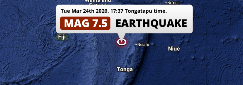
In the late afternoon of Tuesday March 24th, 2026, an unusually powerful M7.5 earthquake hit in the South Pacific Ocean 277 kilometer from Nuku‘alofa, Tonga. Shaking may have been felt by a total of 110 thousand people.
Felt the earthquake? Share this article: 


Earthquake Summary
This earthquake hit under water in the South Pacific Ocean, 166 kilometers (103 mi) off the coast of Tonga, 277 kilometer north of Nuku‘alofa in Tongatapu. The center of this earthquake had an intermediate depth of 230 km.
| Date and Time: | Mar 24, 2026 05:37PM (Tongatapu Time) - Mar 24, 2026 04:37 Universal Time. |
|---|---|
| Location: | 277 km north of Nuku‘alofa, Tongatapu, Tonga. Coordinates 18°40'4"S 175°33'36"W. |
| Map: | 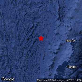 Map of area around epicenter. Click to open in Google Maps. |
| Magnitude: | MAG 7.5 Detected by 13 stations. Maximum Error Range ±0.028 . |
| Depth: | 230 km (143 mi) An intermediate depth. |
| Max. Intensity: | VI
Strong On the Modified Mercalli Scale. |
| Tsunami Risk: | Small (but not impossible) Tsunami Risk Mag 6.5+ earthquakes under sea may cause tsunami's, but the risk is lower as this earthquake appears not to be very shallow. Always stay cautious - More info here. |
Minimal impact predicted
Based on scientific estimates by the US Geographic Survey (USGS), the risk of high fatalities for this earthquake is classified at level GREEN (low). They expect an 90% likelyhood of between 0 and 1 fatalities.
The USGS classifies the economic impact of this earthquake at level GREEN (low). They expect an 90% likelyhood of between 0 and 1 million US Dollars in economic damage and impact.
Roughly 110 thousand people exposed to shaking
The USGS has published a report estimating the number of people exposed to this earthquake. Acoording to their analysis, roughly 110 thousand have been exposed to shaking at an MMI level of II or higher.
An estimated 22,250 people were exposed to level V. At this level, moderate shaking and very light damage can be expected. Intensity level IV was experienced by the majority of people (around 90 thousand). In their region, light shaking and likely no damage can be expected.
People in 2 countries have been exposed to shaking. In Tonga , around 100 thousand people, with impact levels up to V (moderate shaking, very light damage). In Fiji, shaking was experienced too.
| People | MMI Level | Shaking | Damage |
|---|---|---|---|
| 0 | I |
Not noticable | None |
| 0 | II |
Very weak | None |
| 1,780 | III |
Weak | Probably none |
| 85,530 | IV |
Light | Likely none |
| 22,250 | V |
Moderate | Very light |
| 0 | VI |
Strong | Light |
| 0 | VII |
Very Strong | Moderate |
| 0 | VIII |
Severe | Moderate to heavy |
| 0 | IX |
Violent | Heavy |
| 0 | X |
Extreme | Very heavy |
Nearby towns and cities
This earthquake may have been felt in Tonga . The closest significant population center near the earthquake is Nuku‘alofa in Tongatapu, Tonga. Nuku‘alofa is located 277 kilometer (172 mi) north of the epicenter. The intensity of shaking and damage in Nuku‘alofa is estimated to be around level IV on the Modified Mercalli Intensity scale (light shaking, likely no damage).
A complete list of nearby places is included below. Estimated intensity data (MMI) sourced from a shake-map published by the US Geographic Survey is shown where available (cities without data probably experienced little impact).
Overview of nearby places
| Distance | Place | Intensity (MMI) |
|---|---|---|
| 277 km (172 mi) S from epicenter |
Nuku‘alofa Tongatapu, Tonga. |
IV
Light |
| 593 km (368 mi) NW from epicenter |
Labasa Northern, Fiji. |
|
| 595 km (370 mi) E from epicenter |
Alofi All regions, Niue. |
|
| 603 km (375 mi) N from epicenter |
Mata-Utu Uvea, Wallis and Futuna. |
|
| 636 km (395 mi) W from epicenter |
Suva Central, Fiji. |
|
| 673 km (418 mi) NE from epicenter |
Apia Tuamasaga, Samoa. |
|
| 712 km (442 mi) NE from epicenter |
Pago Pago Eastern District, American Samoa. |
|
| 748 km (465 mi) W from epicenter |
Lautoka Western, Fiji. |
|
| 748 km (465 mi) W from epicenter |
Nadi Western, Fiji. |
Earthquake Intensity Map
The maximum intensity (MMI Scale) caused by this earthquake is V. The map below shows in which areas this earthquake was the most and least impactful. It is based on data from the US Geographic Survey.

Shaking reported by 14 people in 2 countries
People that feel an earthquake may report their experience to the US Geographic Survey. Currently, 14 people have reported shaking in 6 places in 2 countries (Tonga, Samoa).We keep updating this article as more ground reports become available. You may report that you felt this earthquake here.
Places with most reports:
- Nukuʿalofa, Tongatapu, Tonga: 7 people.
- Neiafu, Vavaʿu, Tonga: 2 people.
- Tofoa-Koloua, Tongatapu, Tonga: 2 people.
- Pangai, Haʿapai, Tonga: 1 person.
- Ohonua, Eua, Tonga: 1 person.
- Maninoa, Rest of Upolu, Samoa: 1 person.
7 Aftershocks detected
After this earthquake struck, 7 smaller aftershocks occurred. At a distance of 25 km (15 mi) north-east of this earthquake, an aftershock struck 45 mins later. It measured a magnitude of 5.2
Overview of foreshocks and aftershocks
| Classification | Magnitude | When | Where |
|---|---|---|---|
| Main Shock This Earthquake |
M 7.5 |
Mar 24, 2026 05:37PM (Tongatapu Time) | - |
| Aftershock | M 4.9 |
41 mins later Mar 24, 2026 06:18PM (Tongatapu Time) | 60 km (37 mi) NE from Main Shock. |
| Aftershock | M 5.2 |
45 mins later Mar 24, 2026 06:22PM (Tongatapu Time) | 25 km (15 mi) NE from Main Shock. |
| Aftershock | M 4.6 |
2 hrs later Mar 24, 2026 07:45PM (Tongatapu Time) | 11 km (7 mi) NE from Main Shock. |
| Aftershock | M 4.6 |
17 hrs later Mar 25, 2026 10:57AM (Tongatapu Time) | 11 km (7 mi) NE from Main Shock. |
| Aftershock | M 4.6 |
17 hrs later Mar 25, 2026 10:57AM (Tongatapu Time) | 18 km (11 mi) NW from Main Shock. |
| Aftershock | M 4.9 |
22 hrs later Mar 25, 2026 03:24PM (Tongatapu Time) | 31 km (20 mi) E from Main Shock. |
| Aftershock | M 4.6 |
1 day later Mar 25, 2026 08:35PM (Tongatapu Time) | 43 km (26 mi) NE from Main Shock. |
More earthquakes coming?
Aftershocks are usually at least 1 order of magnitude less strong than main shocks. The more time passes, the smaller the chance and likely strength of any potential aftershocks.
In only six percent of cases, significant earthquakes are followed by a larger main shock, making the current earthquake a foreshock. While the chance of this happening is not so large, it is adviced to maintain cautiousness in the hours and days following a major earthquake.
Read: How to Stay Safe during an Earthquake (cdc.gov).This is the strongest earthquake in 8 years
Earthquakes of this strength are not so common in the region, but it's not the first time. This is the strongest earthquake to hit since August 19th, 2018, when a 8.2 magnitude earthquake hit 280 km (174 mi) further west. That was also the heaviest earthquake to hit the region in the past 10 years.
In total, 1 earthquake with a magnitude of 7.5 or higher have been registered within 300km (186 mi) of this epicenter in the past 10 years. This comes down to an average of once every 10 years.
Small (but not impossible) Tsunami Risk
Tsunami's are usually triggered by shallow earthquakes occurring at a maximum depth of a 100km. Based on early data it appears this earthquake was not shallow. However this was a very strong earthquake with it's epicenter under sea. Stay very cautious and monitor advice from local authorities.
Tsunami Risk Factors
| Factor | Under Sea? | MAG-6.5 or stronger? | Shallow depth? |
|---|---|---|---|
| Explanation | Almost all tsunami's are caused by earthquakes with their epicenter under sea or very near the sea. However stay cautious in coastal areas as earthquakes on land may cause landslides into sea, potentially still causing a local tsunami. | Under MAG 6.5: Very unlikely to cause a tsunami. MAG 6.5 to 7.5: Destructive tsunami's do occur, but are uncommon. Likely to observe small sea level changes. MAG 7.6+: Earthquakes with these magnitudes might produce destructive tsunami's. |
Most destructive tsunami's are caused by shallow earthquakes with a depth between 0 and 100km under the surface of the earth. Deeper tsunami's are unlikely to displace to ocean floor. |
| This Earthquake | This earthquake appears to have struck under the sea. | This earthquake had a magnitude of 7.5. Earthquakes of this strength could trigger a tsunami. | Not this earthquake. This earthquake occurred at a depth of 230 km (143 mi). Earthquakes this deep in the earth are unlikely to trigger a tsunami. |
Sources
Last updated 01/04/26 00:38 (). This article contains currently available information about the earthquake and is automatically composed. We continue to update this article up to a few days after the earthquake occurred.
- US Geographic Society (USGS): Earthquake us7000s789
- European-Mediterranean Seismological Centre (EMSC): Earthquake 20260324_0000076
- Geonames.org: World Cities Database
- Google Maps: Static API
- Earthquakelist.org: Historic Earthquakes Database
Share this article:
