In the evening of Saturday March 21st, 2026, a shallow and significant M5.4 earthquake hit in the Philippine Sea 238 kilometer from Kagoshima, Japan. Roughly 140 thousand people may have felt this earthquake.
Felt the earthquake? Share this article: 


Earthquake Summary
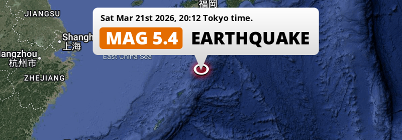
This earthquake hit under water in the Philippine Sea, 92 kilometers (57 mi) off the coast of Japan, 238 kilometer south of Kagoshima. The center of this earthquake had a quite shallow depth of 26 km. Shallow earthquakes usually have a larger impact than earthquakes deep in the earth.
| Date and Time: | Mar 21, 2026 20:12 (Tokyo Time) - Mar 21, 2026 11:12 Universal Time. |
|---|---|
| Location: | 238 km south of Kagoshima, Japan. Coordinates 29°25'39"N 130°43'35"E. |
| Map: | 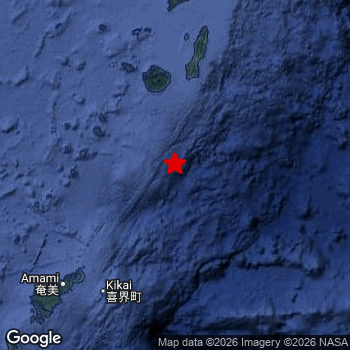 Map of area around epicenter. Click to open in Google Maps. |
| Magnitude: | MAG 5.4 Detected by 24 stations. Maximum Error Range ±0.063 . |
| Depth: | 26 km (16 mi) A quite shallow depth. |
| Max. Intensity: | IV
Light On the Modified Mercalli Scale. |
| Tsunami Risk: | Low tsunami risk Earthquakes under MAG-6.5 do not usually cause tsunami's. Always stay cautious - More info here. |
Minimal impact predicted
Based on scientific estimates by the US Geographic Survey (USGS), the risk of high fatalities for this earthquake is classified at level GREEN (low). They expect an 90% likelyhood of between 0 and 1 fatalities.
The USGS classifies the economic impact of this earthquake at level GREEN (low). They expect an 90% likelyhood of between 0 and 1 million US Dollars in economic damage and impact.
Roughly 140 thousand people exposed to shaking
An estimated 140 thousand have been exposed to shaking (An MMI or Modified Mercalli Intensity level II or higher) as a result of this earthquake according scientific estimates published by the USGS.
The highest earthquake impact level for this earthquake is III, which corresponds with weak shaking and probably no damage. Roughly 113,700 people are expected to be exposed to this level. All exposure to shaking was within the borders of Japan .
| People | MMI Level | Shaking | Damage |
|---|---|---|---|
| 0 | I |
Not noticable | None |
| 29,760 | II |
Very weak | None |
| 113,700 | III |
Weak | Probably none |
| 0 | IV |
Light | Likely none |
| 0 | V |
Moderate | Very light |
| 0 | VI |
Strong | Light |
| 0 | VII |
Very Strong | Moderate |
| 0 | VIII |
Severe | Moderate to heavy |
| 0 | IX |
Violent | Heavy |
| 0 | X |
Extreme | Very heavy |
Nearby towns and cities
This earthquake may have been felt in Japan . Nishinoomote in Kagoshima, Japan is the nearest significant place from the epicenter. The earthquake occurred 148 kilometer (92 mi) south of Nishinoomote. The intensity of shaking and damage in Nishinoomote is estimated to be around level III on the Modified Mercalli Intensity scale (weak shaking, probably no damage).
Multiple large cities are in proximity of today's earthquake. Kagoshima is located 238 km to the north (intensity unknown, possibly low). Miyazaki is located 285 km to the north (intensity unknown, possibly low). Miyakonojō is located 258 km to the north (intensity unknown, possibly low).
An overview of nearby towns and cities is available in the overview below. If places don't have intensity data available, it likely means the experienced impact in those places was fairly small.
Overview of nearby places
| Distance | Place | Intensity (MMI) |
|---|---|---|
| 148 km (92 mi) N from epicenter |
Nishinoomote Kagoshima, Japan. |
III
Weak |
| 169 km (105 mi) SW from epicenter |
Naze Kagoshima, Japan. |
III
Weak |
| 201 km (125 mi) N from epicenter |
Ibusuki Kagoshima, Japan. |
|
| 208 km (129 mi) N from epicenter |
Makurazaki Kagoshima, Japan. |
|
| 218 km (135 mi) N from epicenter |
Kanoya Kagoshima, Japan. |
|
| 225 km (140 mi) N from epicenter |
Kaseda-shirakame Kagoshima, Japan. |
|
| 229 km (142 mi) N from epicenter |
Tarumizu Kagoshima, Japan. |
|
| 231 km (144 mi) N from epicenter |
Shibushi Kagoshima, Japan. |
|
| 234 km (145 mi) N from epicenter |
Kushima Miyazaki, Japan. |
|
| 238 km (148 mi) N from epicenter |
Kagoshima Kagoshima, Japan. |
|
| 245 km (152 mi) N from epicenter |
Ijūin Kagoshima, Japan. |
|
| 249 km (155 mi) N from epicenter |
Nichinan Miyazaki, Japan. |
|
| 249 km (155 mi) N from epicenter |
Sueyoshichō-ninokata Kagoshima, Japan. |
|
| 255 km (158 mi) N from epicenter |
Hamanoichi Kagoshima, Japan. |
|
| 256 km (159 mi) N from epicenter |
Kokubu-matsuki Kagoshima, Japan. |
|
| 256 km (159 mi) N from epicenter |
Kajiki Kagoshima, Japan. |
|
| 258 km (160 mi) N from epicenter |
Kushikino Kagoshima, Japan. |
|
| 258 km (160 mi) N from epicenter |
Miyakonojō Miyazaki, Japan. |
|
| 269 km (167 mi) N from epicenter |
Satsumasendai Kagoshima, Japan. |
|
| 285 km (177 mi) N from epicenter |
Miyazaki Miyazaki, Japan. |
|
| 285 km (177 mi) N from epicenter |
Kobayashi Miyazaki, Japan. |
|
| 292 km (181 mi) N from epicenter |
Akune Kagoshima, Japan. |
|
| 294 km (183 mi) N from epicenter |
Ōkuchi-shinohara Kagoshima, Japan. |
|
| 297 km (185 mi) N from epicenter |
Izumi Kagoshima, Japan. |
Earthquake Intensity Map
The intensity in shaking and damage by this earthquake is illustrated through the map below. The highest intensity measured for this earthquake is IV.

2 Aftershocks detected
This main shock was followed by 2 smaller aftershocks. A 4.6 magnitude earthquake hit 2 days later 11 km (7 mi) west of this earthquake.
Overview of foreshocks and aftershocks
| Classification | Magnitude | When | Where |
|---|---|---|---|
| Main Shock This Earthquake |
M 5.4 |
Mar 21, 2026 20:12 (Tokyo Time) | - |
| Aftershock | M 4.5 |
41 mins later Mar 21, 2026 20:53 (Tokyo Time) | 11 km (7 mi) W from Main Shock. |
| Aftershock | M 4.6 |
2 days later Mar 23, 2026 21:39 (Tokyo Time) | 11 km (7 mi) W from Main Shock. |
More earthquakes coming?
Aftershocks are usually at least 1 order of magnitude less strong than main shocks. The more time passes, the smaller the chance and likely strength of any potential aftershocks.
The chance that a significant earthquake like this one is followed by an even larger earthquake is not so large. On average, scientists estimate a 94% chance that a major earthquake will not be followed by an even larger one. It is still adviced to be aware of this risk
Read: How to Stay Safe during an Earthquake (cdc.gov).Earthquakes like this happen often in the region
Earthquakes of this strength are very common in the region. This is the strongest earthquake to hit since March 1st, 2026, when a 5.5 magnitude earthquake hit 188 km (117 mi) further north. An even stronger magnitude 7.1 earthquake struck on August 8th, 2024.
In total, 51 earthquakes with a magnitude of 5.4 or higher have been registered within 300km (186 mi) of this epicenter in the past 10 years. This comes down to an average of once every 2 months.
Low tsunami risk
Based on early data it appears this earthquake was not strong enough (lower than MAG-6.5) to be likely to cause destructive tsunami's. However this earthquake appeared to have hit at a shallow depth under sea, so stay cautious and monitor advice from local authorities.
Tsunami Risk Factors
| Factor | Under Sea? | MAG-6.5 or stronger? | Shallow depth? |
|---|---|---|---|
| Explanation | Almost all tsunami's are caused by earthquakes with their epicenter under sea or very near the sea. However stay cautious in coastal areas as earthquakes on land may cause landslides into sea, potentially still causing a local tsunami. | Under MAG 6.5: Very unlikely to cause a tsunami. MAG 6.5 to 7.5: Destructive tsunami's do occur, but are uncommon. Likely to observe small sea level changes. MAG 7.6+: Earthquakes with these magnitudes might produce destructive tsunami's. |
Most destructive tsunami's are caused by shallow earthquakes with a depth between 0 and 100km under the surface of the earth. Deeper tsunami's are unlikely to displace to ocean floor. |
| This Earthquake | This earthquake appears to have struck under the sea. | Not this earthquake. This earthquake had a magnitude of 5.4. Earthquakes of this strength are unlikely to trigger a tsunami. |
This earthquake occurred at a depth of of 26 km (16 mi). Earthquakes this shallow could trigger a tsunami. |
Sources
Last updated 31/03/26 11:18 (). This article contains currently available information about the earthquake and is automatically composed. We continue to update this article up to a few days after the earthquake occurred.
- US Geographic Society (USGS): Earthquake us6000si57
- European-Mediterranean Seismological Centre (EMSC): Earthquake 20260321_0000202
- Geonames.org: World Cities Database
- Google Maps: Static API
- Earthquakelist.org: Historic Earthquakes Database
Share this article:
