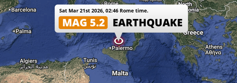
In the night of Saturday March 21st, 2026, a shallow and significant MAG-5.2 earthquake hit in the Tirreno Sea 93 kilometer from Palermo, Italy. Another nearby country is Malta.
Felt the earthquake? Share this article: 


Earthquake Summary
This earthquake hit under water in the Tirreno Sea, 56 kilometers (35 mi) off the coast of Italy, 93 kilometer north-east of Palermo in Sicily. The center of this earthquake had a very shallow depth of 10 km. Shallow earthquakes usually have a larger impact than earthquakes deep in the earth.
| Date and Time: | Mar 21, 2026 02:46 (Rome Time) - Mar 21, 2026 01:46 Universal Time. |
|---|---|
| Location: | 93 km NE of Palermo, Sicily, Italy. Coordinates 38°30'46"N 14°17'23"E. |
| Map: | 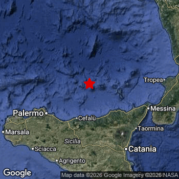 Map of area around epicenter. Click to open in Google Maps. |
| Magnitude: | MAG 5.2 Detected by 286 stations. Maximum Error Range ±0.034 . |
| Depth: | 10 km (6 mi) A very shallow depth. |
| Tsunami Risk: | Low tsunami risk Earthquakes under MAG-6.5 do not usually cause tsunami's. Always stay cautious - More info here. |
Nearby towns and cities
2 countries can be found within 300km of the epicenter of this earthquake: Italy and Malta .
Located 78 kilometer (48 mi) north-east of the epicenter of this earthquake, Termini Imerese (Sicily, Italy) is the nearest significant population center.
Major cities near this earthquake: Palermo is located 93 km to the southwest. Naples is located 260 km to the north. Catania is located 132 km to the south-east.
The table below provides an overview of all places in proximity of today's earthquake.
Overview of nearby places
| Distance | Place |
|---|---|
| 78 km (48 mi) SW from epicenter |
Termini Imerese Sicily, Italy. |
| 83 km (52 mi) SW from epicenter |
Bagheria Sicily, Italy. |
| 88 km (55 mi) SW from epicenter |
Villabate Sicily, Italy. |
| 89 km (55 mi) E from epicenter |
Milazzo Sicily, Italy. |
| 90 km (56 mi) SE from epicenter |
Barcellona Pozzo di Gotto Sicily, Italy. |
| 91 km (57 mi) SW from epicenter |
Misilmeri Sicily, Italy. |
| 93 km (58 mi) SW from epicenter |
Palermo Sicily, Italy. |
| 94 km (58 mi) SE from epicenter |
Bronte Sicily, Italy. |
| 100 km (62 mi) SW from epicenter |
Monreale Sicily, Italy. |
| 105 km (65 mi) SW from epicenter |
Carini Sicily, Italy. |
| 105 km (65 mi) S from epicenter |
Enna Sicily, Italy. |
| 106 km (66 mi) SE from epicenter |
Adrano Sicily, Italy. |
| 109 km (68 mi) SE from epicenter |
Biancavilla Sicily, Italy. |
| 115 km (71 mi) S from epicenter |
Caltanissetta Sicily, Italy. |
| 115 km (71 mi) SW from epicenter |
Partinico Sicily, Italy. |
| 116 km (72 mi) E from epicenter |
Messina Sicily, Italy. |
| 117 km (73 mi) S from epicenter |
San Cataldo Sicily, Italy. |
| 117 km (73 mi) SE from epicenter |
Giarre Sicily, Italy. |
| 118 km (73 mi) SE from epicenter |
Paternò Sicily, Italy. |
| 119 km (74 mi) SE from epicenter |
Belpasso Sicily, Italy. |
| 124 km (77 mi) SE from epicenter |
Mascalucia Sicily, Italy. |
| 125 km (78 mi) SE from epicenter |
Aci Catena Sicily, Italy. |
| 126 km (78 mi) SE from epicenter |
San Giovanni la Punta Sicily, Italy. |
| 126 km (78 mi) SE from epicenter |
Acireale Sicily, Italy. |
| 126 km (78 mi) S from epicenter |
Piazza Armerina Sicily, Italy. |
| 126 km (78 mi) SE from epicenter |
Gravina di Catania Sicily, Italy. |
| 127 km (79 mi) SE from epicenter |
Misterbianco Sicily, Italy. |
| 128 km (80 mi) E from epicenter |
Reggio Calabria Calabria, Italy. |
| 130 km (81 mi) SW from epicenter |
Alcamo Sicily, Italy. |
| 132 km (82 mi) SE from epicenter |
Catania Sicily, Italy. |
| 134 km (83 mi) S from epicenter |
Canicattì Sicily, Italy. |
| 143 km (89 mi) S from epicenter |
Caltagirone Sicily, Italy. |
| 144 km (89 mi) S from epicenter |
Favara Sicily, Italy. |
| 148 km (92 mi) SW from epicenter |
Agrigento Sicily, Italy. |
| 152 km (94 mi) S from epicenter |
Niscemi Sicily, Italy. |
| 154 km (96 mi) SW from epicenter |
Sciacca Sicily, Italy. |
| 160 km (99 mi) S from epicenter |
Licata Sicily, Italy. |
| 160 km (99 mi) S from epicenter |
Gela Sicily, Italy. |
| 160 km (99 mi) SW from epicenter |
Castelvetrano Sicily, Italy. |
| 163 km (101 mi) SE from epicenter |
Augusta Sicily, Italy. |
| 163 km (101 mi) W from epicenter |
Trapani Sicily, Italy. |
| 175 km (109 mi) S from epicenter |
Vittoria Sicily, Italy. |
| 177 km (110 mi) SW from epicenter |
Mazara del Vallo Sicily, Italy. |
| 180 km (112 mi) SW from epicenter |
Marsala Sicily, Italy. |
| 181 km (112 mi) S from epicenter |
Ragusa Sicily, Italy. |
| 182 km (113 mi) E from epicenter |
Lamezia Terme Calabria, Italy. |
| 182 km (113 mi) SE from epicenter |
Siracusa Sicily, Italy. |
| 183 km (114 mi) E from epicenter |
Nicastro Calabria, Italy. |
| 189 km (117 mi) S from epicenter |
Modica Sicily, Italy. |
| 191 km (119 mi) NE from epicenter |
Cosenza Calabria, Italy. |
| 260 km (162 mi) N from epicenter |
Naples Campania, Italy. |
| 270 km (168 mi) NE from epicenter |
Potenza Basilicate, Italy. |
| 290 km (180 mi) S from epicenter |
Mosta Il-Mosta, Malta. |
| 291 km (181 mi) S from epicenter |
Birkirkara Birkirkara, Malta. |
| 291 km (181 mi) S from epicenter |
Valletta Valletta, Malta. |
| 294 km (183 mi) S from epicenter |
Qormi Qormi, Malta. |
| 294 km (183 mi) S from epicenter |
Żabbar Ħaż-Żabbar, Malta. |
Shaking reported by 2 people
People that feel an earthquake may report their experience to the US Geographic Survey. Currently, 2 people have reported shaking in 2 places in Italy.We keep updating this article as more ground reports become available. You may report that you felt this earthquake here.
Places with most reports:
- Palermo, Sizilien, Italy: 1 person.
- Calatabiano, Sizilien, Italy: 1 person.
19 Aftershocks detected
Since this main shock, 19 smaller aftershocks were detected. At a distance of 9 km (6 mi) southwest of this earthquake, an aftershock struck 3 mins later. It measured a magnitude of 4.3
Overview of foreshocks and aftershocks
| Classification | Magnitude | When | Where |
|---|---|---|---|
| Main Shock This Earthquake |
M 5.2 |
Mar 21, 2026 02:46 (Rome Time) | - |
| Aftershock | M 4.3 |
3 mins later Mar 21, 2026 02:49 (Rome Time) | 9 km (6 mi) SW from Main Shock. |
| Aftershock | M 3.0 |
7 mins later Mar 21, 2026 02:53 (Rome Time) | 8 km (5 mi) W from Main Shock. |
| Aftershock | M 2.7 |
10 mins later Mar 21, 2026 02:55 (Rome Time) | 6 km (4 mi) W from Main Shock. |
| Aftershock | M 2.9 |
11 mins later Mar 21, 2026 02:57 (Rome Time) | 8 km (5 mi) W from Main Shock. |
| Aftershock | M 2.6 |
40 mins later Mar 21, 2026 03:25 (Rome Time) | 8 km (5 mi) W from Main Shock. |
| Aftershock | M 2.8 |
1 hr later Mar 21, 2026 04:00 (Rome Time) | 7 km (4 mi) W from Main Shock. |
| Aftershock | M 2.7 |
1 hr later Mar 21, 2026 04:02 (Rome Time) | 8 km (5 mi) W from Main Shock. |
| Aftershock | M 2.5 |
2 hrs later Mar 21, 2026 04:28 (Rome Time) | 6 km (4 mi) W from Main Shock. |
| Aftershock | M 2.5 |
6 hrs later Mar 21, 2026 08:31 (Rome Time) | 66 km (41 mi) S from Main Shock. |
| Aftershock | M 3.5 |
16 hrs later Mar 21, 2026 19:03 (Rome Time) | 64 km (40 mi) S from Main Shock. |
| Aftershock | M 3.0 |
16 hrs later Mar 21, 2026 19:04 (Rome Time) | 69 km (43 mi) S from Main Shock. |
| Aftershock | M 4.1 |
16 hrs later Mar 21, 2026 19:04 (Rome Time) | 71 km (44 mi) S from Main Shock. |
| Aftershock | M 4.1 |
16 hrs later Mar 21, 2026 19:04 (Rome Time) | 55 km (34 mi) SE from Main Shock. |
| Aftershock | M 3.3 |
16 hrs later Mar 21, 2026 19:06 (Rome Time) | 68 km (42 mi) S from Main Shock. |
| Aftershock | M 3.0 |
16 hrs later Mar 21, 2026 19:15 (Rome Time) | 66 km (41 mi) S from Main Shock. |
| Aftershock | M 2.5 |
17 hrs later Mar 21, 2026 20:09 (Rome Time) | 67 km (42 mi) S from Main Shock. |
| Aftershock | M 2.8 |
17 hrs later Mar 21, 2026 20:09 (Rome Time) | 65 km (41 mi) S from Main Shock. |
| Aftershock | M 2.5 |
18 hrs later Mar 21, 2026 20:24 (Rome Time) | 68 km (42 mi) S from Main Shock. |
| Aftershock | M 2.6 |
2 days later Mar 22, 2026 16:28 (Rome Time) | 10 km (6 mi) W from Main Shock. |
More earthquakes coming?
The risk of aftershocks decreases rapidly over time. Usually, aftershocks are at least one order of magnitude lower than a main shock.
In only six percent of cases, significant earthquakes are followed by a larger main shock, making the current earthquake a foreshock. While the chance of this happening is not so large, it is adviced to maintain cautiousness in the hours and days following a major earthquake.
Read: How to Stay Safe during an Earthquake (cdc.gov).Earthquakes like this are common in the region
Earthquakes of this strength occur quite regularly in the region. This is the strongest earthquake to hit since March 9th, 2026, when a 6 magnitude earthquake hit 231 km (144 mi) further north. That was also the heaviest earthquake to hit the region in the past 10 years.
In total, 3 earthquakes with a magnitude of 5.2 or higher have been registered within 300km (186 mi) of this epicenter in the past 10 years. This comes down to an average of once every 3 years.
Low tsunami risk
Based on early data it appears this earthquake was not strong enough (lower than MAG-6.5) to be likely to cause destructive tsunami's. However this earthquake appeared to have hit at a shallow depth under sea, so stay cautious and monitor advice from local authorities.
Tsunami Risk Factors
| Factor | Under Sea? | MAG-6.5 or stronger? | Shallow depth? |
|---|---|---|---|
| Explanation | Almost all tsunami's are caused by earthquakes with their epicenter under sea or very near the sea. However stay cautious in coastal areas as earthquakes on land may cause landslides into sea, potentially still causing a local tsunami. | Under MAG 6.5: Very unlikely to cause a tsunami. MAG 6.5 to 7.5: Destructive tsunami's do occur, but are uncommon. Likely to observe small sea level changes. MAG 7.6+: Earthquakes with these magnitudes might produce destructive tsunami's. |
Most destructive tsunami's are caused by shallow earthquakes with a depth between 0 and 100km under the surface of the earth. Deeper tsunami's are unlikely to displace to ocean floor. |
| This Earthquake | This earthquake appears to have struck under the sea. | Not this earthquake. This earthquake had a magnitude of 5.2. Earthquakes of this strength are unlikely to trigger a tsunami. |
This earthquake occurred at a depth of of 10 km (6 mi). Earthquakes this shallow could trigger a tsunami. |
Sources
Last updated 01/04/26 02:38 (). This article is automatically generated based on available data. We keep checking multiple sources for additional information. This article gets updated as new details on this earthquake become available.
- US Geographic Society (USGS): Earthquake us6000si0l
- European-Mediterranean Seismological Centre (EMSC): Earthquake 20260321_0000030
- Geonames.org: World Cities Database
- Google Maps: Static API
- Earthquakelist.org: Historic Earthquakes Database
Share this article:
