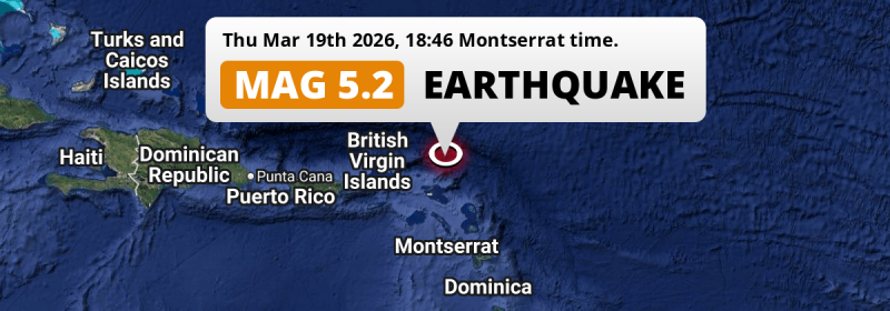
In the evening of Thursday March 19th, 2026, a shallow and significant MAG-5.2 earthquake hit in the North Atlantic Ocean 94 kilometer from The Valley, Anguilla. Other countries near the epicenter include Saint Kitts and Nevis, Antigua and Barbuda, British Virgin Islands, Montserrat and U.S. Virgin Islands.
Felt the earthquake? Share this article: 


Earthquake Summary
This earthquake hit under water in the North Atlantic Ocean, 85 kilometers (53 mi) off the coast of Anguilla, 94 kilometer north-east of The Valley. The center of this earthquake had a very shallow depth of 10 km. Shallow earthquakes usually have a larger impact than earthquakes deep in the earth.
| Date and Time: | Mar 19, 2026 18:46 (Anguilla Time) - Mar 19, 2026 22:46 Universal Time. |
|---|---|
| Location: | 94 km NE of The Valley, Anguilla. Coordinates 18°56'33"N 62°36'21"W. |
| Map: | 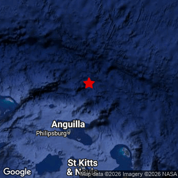 Map of area around epicenter. Click to open in Google Maps. |
| Magnitude: | MAG 5.2 Detected by 14 stations. Maximum Error Range ±0.083 . |
| Depth: | 10 km (6 mi) A very shallow depth. |
| Tsunami Risk: | Low tsunami risk Earthquakes under MAG-6.5 do not usually cause tsunami's. Always stay cautious - More info here. |
Nearby towns and cities
This earthquake struck within proximity of multiple countries. Anguilla , Saint Kitts and Nevis , Antigua and Barbuda , British Virgin Islands , Montserrat and U.S. Virgin Islands are all within 300km distance of its epicenter.
Located 94 kilometer (58 mi) north-east of the epicenter of this earthquake, The Valley (The Valley, Anguilla) is the nearest significant population center.
An overview of nearby towns and cities is available in the overview below.
Overview of nearby places
| Distance | Place |
|---|---|
| 94 km (58 mi) SW from epicenter |
The Valley The Valley, Anguilla. |
| 109 km (68 mi) SW from epicenter |
Marigot All regions, Saint Martin. |
| 119 km (74 mi) S from epicenter |
Gustavia All regions, Saint Barthelemy. |
| 184 km (114 mi) S from epicenter |
Basseterre Saint George Basseterre, Saint Kitts and Nevis. |
| 218 km (135 mi) S from epicenter |
Saint John’s Saint John, Antigua and Barbuda. |
| 220 km (137 mi) W from epicenter |
Road Town All regions, British Virgin Islands. |
| 243 km (151 mi) S from epicenter |
Brades Saint Peter, Montserrat. |
| 252 km (157 mi) S from epicenter |
Plymouth Saint Anthony, Montserrat. |
| 254 km (158 mi) W from epicenter |
Charlotte Amalie Saint Thomas Island, U.S. Virgin Islands. |
| 263 km (163 mi) SW from epicenter |
Saint Croix Saint Croix Island, U.S. Virgin Islands. |
Risk of aftershocks?
We monitor for foreshocks or aftershocks that have a magnitude of 2.5+ and occur within 100km (62 mi) of the epicenter of this earthquake. So far no such earthquakes have been detected.
The risk of aftershocks decreases rapidly over time. Usually, aftershocks are at least one order of magnitude lower than a main shock.
It's always adviced to be cautious of the risk of a larger shock following any significant earthquake, however this risk is fairly small. There is a roughly 94 percent change that no larger main shock will follow in the days following this earthquake.
Read: How to Stay Safe during an Earthquake (cdc.gov).Earthquakes like this are common in the region
Earthquakes of this strength occur quite regularly in the region. This is the strongest earthquake to hit since May 4th, 2025, when a 5.6 magnitude earthquake hit 180 km (112 mi) further west. An even stronger magnitude 6.6 earthquake struck on July 10th, 2023.
In total, 8 earthquakes with a magnitude of 5.2 or higher have been registered within 300km (186 mi) of this epicenter in the past 10 years. This comes down to an average of once every year.
Low tsunami risk
Based on early data it appears this earthquake was not strong enough (lower than MAG-6.5) to be likely to cause destructive tsunami's. However this earthquake appeared to have hit at a shallow depth under sea, so stay cautious and monitor advice from local authorities.
Tsunami Risk Factors
| Factor | Under Sea? | MAG-6.5 or stronger? | Shallow depth? |
|---|---|---|---|
| Explanation | Almost all tsunami's are caused by earthquakes with their epicenter under sea or very near the sea. However stay cautious in coastal areas as earthquakes on land may cause landslides into sea, potentially still causing a local tsunami. | Under MAG 6.5: Very unlikely to cause a tsunami. MAG 6.5 to 7.5: Destructive tsunami's do occur, but are uncommon. Likely to observe small sea level changes. MAG 7.6+: Earthquakes with these magnitudes might produce destructive tsunami's. |
Most destructive tsunami's are caused by shallow earthquakes with a depth between 0 and 100km under the surface of the earth. Deeper tsunami's are unlikely to displace to ocean floor. |
| This Earthquake | This earthquake appears to have struck under the sea. | Not this earthquake. This earthquake had a magnitude of 5.2. Earthquakes of this strength are unlikely to trigger a tsunami. |
This earthquake occurred at a depth of of 10 km (6 mi). Earthquakes this shallow could trigger a tsunami. |
Sources
Last updated 31/03/26 23:08 (). This article contains currently available information about the earthquake and is automatically composed. We continue to update this article up to a few days after the earthquake occurred.
- US Geographic Society (USGS): Earthquake us6000shkh
- European-Mediterranean Seismological Centre (EMSC): Earthquake 20260319_0000382
- Geonames.org: World Cities Database
- Google Maps: Static API
- Earthquakelist.org: Historic Earthquakes Database
Share this article:
