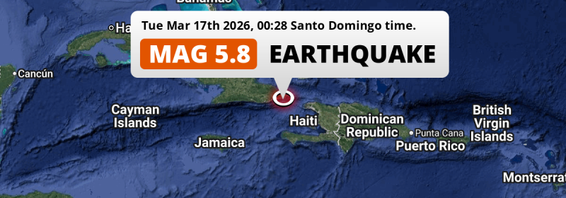
In the Caribbean Sea 95 kilometer from Guantánamo, Cuba, a shallow and significant Magnitude 5.8 earthquake occurred just after midnight of Tuesday March 17th, 2026. Around 9 million people have been exposed to shaking. Other countries near the epicenter include Haiti, Dominican Republic and Jamaica.
Felt the earthquake? Share this article: 


Earthquake Summary
This earthquake hit under water in the Caribbean Sea, 25 kilometers (16 mi) off the coast of Cuba, 95 kilometer east of Guantánamo. The center of this earthquake had a very shallow depth of 12 km. Shallow earthquakes usually have a larger impact than earthquakes deep in the earth.
| Date and Time: | Mar 17, 2026 00:28 (Havana Time) - Mar 17, 2026 04:28 Universal Time. |
|---|---|
| Location: | 95 km east of Guantánamo, Cuba. Coordinates 19°50'24"N 74°21'31"W. |
| Map: | 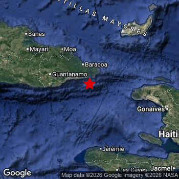 Map of area around epicenter. Click to open in Google Maps. |
| Magnitude: | MAG 5.8 Detected by 66 stations. Maximum Error Range ±0.038 . |
| Depth: | 12 km (7 mi) A very shallow depth. |
| Max. Intensity: | VI
Strong On the Modified Mercalli Scale. |
| Tsunami Risk: | Low tsunami risk Earthquakes under MAG-6.5 do not usually cause tsunami's. Always stay cautious - More info here. |
Minimal impact predicted
Based on scientific estimates by the US Geographic Survey (USGS), the risk of high fatalities for this earthquake is classified at level GREEN (low). They expect an 90% likelyhood of between 0 and 1 fatalities.
The USGS classifies the economic impact of this earthquake at level GREEN (low). They expect an 94% likelyhood of between 0 and 1 million US Dollars in economic damage and impact.
Roughly 9 million people exposed to shaking
This earthquake may have been felt by around 9 million people. That is the expected population size of the area exposed to a level of shaking of II or higher on the Modified Mercalli scale according to the USGS.
The highest earthquake impact level for this earthquake is V, which corresponds with moderate shaking and very light damage. Roughly 16,070 people are expected to be exposed to this level. The majority of people (roughly 8 million) live in an area exposed to level III, where weak shaking and probably no damage is expected.
People in 5 countries have been exposed to shaking. In Cuba , around 1.9 million people, with impact levels up to V (moderate shaking, very light damage). Roughly 6.7 million people were exposed to shaking in Haiti . In The Bahamas, shaking was experienced too.
| People | MMI Level | Shaking | Damage |
|---|---|---|---|
| 0 | I |
Not noticable | None |
| 56,990 | II |
Very weak | None |
| 7,754,000 | III |
Weak | Probably none |
| 766,200 | IV |
Light | Likely none |
| 16,070 | V |
Moderate | Very light |
| 0 | VI |
Strong | Light |
| 0 | VII |
Very Strong | Moderate |
| 0 | VIII |
Severe | Moderate to heavy |
| 0 | IX |
Violent | Heavy |
| 0 | X |
Extreme | Very heavy |
Nearby towns and cities
5 countries can be found within 300km of the epicenter of this earthquake: Cuba , Haiti , Dominican Republic and Jamaica . Futher away, this earthquake may also have been felt in Turks and Caicos Islands.
Located 50 kilometer (31 mi) southwest of the epicenter of this earthquake, Maisí (Guantánamo, Cuba) is the nearest significant population center. The intensity of shaking and damage in Maisí is estimated to be around level IV on the Modified Mercalli Intensity scale (light shaking, likely no damage).
Multiple major population centers exist within 300km of the earthquake that struck today. Port-au-Prince is located 256 km to the south-east (intensity unknown, possibly low). Santiago de Cuba is located 155 km to the west and experienced an intensity of III (weak shaking, probably no damage). Santiago de los Caballeros is located 386 km to the east (intensity unknown, possibly low).
An overview of nearby towns and cities is available in the overview below. If places don't have intensity data available, it likely means the experienced impact in those places was fairly small.
Overview of nearby places
| Distance | Place | Intensity (MMI) |
|---|---|---|
| 50 km (31 mi) NE from epicenter |
Maisí Guantánamo, Cuba. |
IV
Light |
| 58 km (36 mi) N from epicenter |
Baracoa Guantánamo, Cuba. |
IV
Light |
| 90 km (56 mi) NW from epicenter |
Río Guayabal de Yateras Guantánamo, Cuba. |
IV
Light |
| 95 km (59 mi) W from epicenter |
Guantánamo Guantánamo, Cuba. |
IV
Light |
| 110 km (68 mi) NW from epicenter |
Moa Holguín, Cuba. |
IV
Light |
| 124 km (77 mi) NW from epicenter |
Sagua de Tánamo Holguín, Cuba. |
IV
Light |
| 135 km (84 mi) S from epicenter |
Jérémie GrandʼAnse, Haiti. |
III
Weak |
| 155 km (96 mi) W from epicenter |
Santiago de Cuba Santiago de Cuba, Cuba. |
III
Weak |
| 160 km (99 mi) E from epicenter |
Port-de-Paix Nord-Ouest, Haiti. |
III
Weak |
| 160 km (99 mi) E from epicenter |
Ti Port-de-Paix Nord-Ouest, Haiti. |
III
Weak |
| 161 km (100 mi) W from epicenter |
San Luis Santiago de Cuba, Cuba. |
III
Weak |
| 176 km (109 mi) W from epicenter |
Palma Soriano Santiago de Cuba, Cuba. |
III
Weak |
| 180 km (112 mi) E from epicenter |
Gonaïves Artibonite, Haiti. |
III
Weak |
| 187 km (116 mi) NW from epicenter |
Cueto Holguín, Cuba. |
III
Weak |
| 189 km (117 mi) NW from epicenter |
Banes Holguín, Cuba. |
III
Weak |
| 193 km (120 mi) SE from epicenter |
Saint-Marc Artibonite, Haiti. |
III
Weak |
| 194 km (121 mi) S from epicenter |
Les Cayes Sud, Haiti. |
III
Weak |
| 204 km (127 mi) NW from epicenter |
San Germán Holguín, Cuba. |
III
Weak |
| 204 km (127 mi) W from epicenter |
Contramaestre Santiago de Cuba, Cuba. |
|
| 204 km (127 mi) SE from epicenter |
Miragoâne Nippes, Haiti. |
III
Weak |
| 205 km (127 mi) E from epicenter |
Lenbe Nord, Haiti. |
III
Weak |
| 217 km (135 mi) SE from epicenter |
Verrettes Artibonite, Haiti. |
III
Weak |
| 222 km (138 mi) SE from epicenter |
Tigwav Ouest, Haiti. |
III
Weak |
| 224 km (139 mi) W from epicenter |
Jiguaní Granma, Cuba. |
|
| 226 km (140 mi) E from epicenter |
Okap Nord, Haiti. |
|
| 228 km (142 mi) NW from epicenter |
Cacocum Holguín, Cuba. |
|
| 229 km (142 mi) SE from epicenter |
Grangwav Ouest, Haiti. |
III
Weak |
| 230 km (143 mi) NW from epicenter |
Holguín Holguín, Cuba. |
|
| 231 km (144 mi) E from epicenter |
Saint-Raphaël Nord, Haiti. |
|
| 232 km (144 mi) NW from epicenter |
Gibara Holguín, Cuba. |
III
Weak |
| 234 km (145 mi) SE from epicenter |
Léogâne Ouest, Haiti. |
III
Weak |
| 246 km (153 mi) W from epicenter |
Bayamo Granma, Cuba. |
|
| 251 km (156 mi) SE from epicenter |
Carrefour Ouest, Haiti. |
|
| 256 km (159 mi) SE from epicenter |
Port-au-Prince Ouest, Haiti. |
|
| 257 km (160 mi) E from epicenter |
Hinche Centre, Haiti. |
|
| 260 km (162 mi) SE from epicenter |
Delmas 73 Ouest, Haiti. |
|
| 262 km (163 mi) SE from epicenter |
Jacmel Sud-Est, Haiti. |
III
Weak |
| 263 km (163 mi) SE from epicenter |
Pétionville Ouest, Haiti. |
|
| 264 km (164 mi) SE from epicenter |
Croix-des-Bouquets Ouest, Haiti. |
|
| 265 km (165 mi) NW from epicenter |
Jesús Menéndez Las Tunas, Cuba. |
|
| 267 km (166 mi) SE from epicenter |
Kenscoff Ouest, Haiti. |
|
| 272 km (169 mi) W from epicenter |
Bartolomé Masó Granma, Cuba. |
|
| 272 km (169 mi) SE from epicenter |
Thomazeau Ouest, Haiti. |
|
| 278 km (173 mi) NW from epicenter |
Puerto Padre Las Tunas, Cuba. |
|
| 279 km (173 mi) E from epicenter |
Dajabón Dajabón, Dominican Republic. |
|
| 284 km (176 mi) E from epicenter |
San Fernando de Monte Cristi Monte Cristi, Dominican Republic. |
|
| 294 km (183 mi) W from epicenter |
Manzanillo Granma, Cuba. |
|
| 298 km (185 mi) NW from epicenter |
Las Tunas Las Tunas, Cuba. |
|
| 319 km (198 mi) E from epicenter |
Sabaneta Santiago Rodríguez, Dominican Republic. |
|
| 326 km (203 mi) SW from epicenter |
New Kingston St. Andrew, Jamaica. |
|
| 328 km (204 mi) SW from epicenter |
Kingston Kingston, Jamaica. |
|
| 339 km (211 mi) SW from epicenter |
Portmore Saint Catherine, Jamaica. |
|
| 342 km (213 mi) SW from epicenter |
Spanish Town Saint Catherine, Jamaica. |
|
| 344 km (214 mi) SE from epicenter |
Neiba Baoruco, Dominican Republic. |
|
| 345 km (214 mi) E from epicenter |
Mao Valverde, Dominican Republic. |
|
| 348 km (216 mi) E from epicenter |
San Juan de la Maguana San Juan, Dominican Republic. |
|
| 357 km (222 mi) NW from epicenter |
Nuevitas Camagüey, Cuba. |
|
| 368 km (229 mi) SW from epicenter |
May Pen Clarendon, Jamaica. |
|
| 380 km (236 mi) NE from epicenter |
Cockburn Town All regions, Turks and Caicos Islands. |
|
| 384 km (239 mi) E from epicenter |
Puerto Plata Puerto Plata, Dominican Republic. |
|
| 386 km (240 mi) E from epicenter |
Santiago de los Caballeros Santiago, Dominican Republic. |
|
| 387 km (240 mi) SW from epicenter |
Mandeville Manchester, Jamaica. |
|
| 388 km (241 mi) SE from epicenter |
Santa Cruz de Barahona Barahona, Dominican Republic. |
|
| 393 km (244 mi) E from epicenter |
Constanza La Vega, Dominican Republic. |
Earthquake Intensity Map
The maximum intensity (MMI Scale) caused by this earthquake is V. The map below shows in which areas this earthquake was the most and least impactful. It is based on data from the US Geographic Survey.

Shaking reported by 13 people in 4 countries
People that feel an earthquake may report their experience to the US Geographic Survey. Currently, 13 people have reported shaking in 7 places in 4 countries (Cuba, Jamaica, Haiti, Cayman Islands).We keep updating this article as more ground reports become available. You may report that you felt this earthquake here.
Places with most reports:
- Guantánamo, Guantánamo, Cuba: 7 people.
- Baracoa, Guantánamo, Cuba: 1 person.
- Montego Bay, Saint James, Jamaica: 1 person.
- Cap-Haïtien, Nord, Haiti: 1 person.
- Mandeville, Manchester, Jamaica: 1 person.
- Les Cayes, Sud, Haiti: 1 person.
- North Side, _no region, Cayman Islands: 1 person.
11 Aftershocks detected
Since this main shock, 11 smaller aftershocks were detected. Just 16 mins after this main shock, an earthquake measuring MAG-4.7 was detected 11 km (7 mi) south of this earthquake.
Overview of foreshocks and aftershocks
| Classification | Magnitude | When | Where |
|---|---|---|---|
| Main Shock This Earthquake |
M 5.8 |
Mar 17, 2026 00:28 (Havana Time) | - |
| Aftershock | M 4.1 |
6 mins later Mar 17, 2026 00:34 (Havana Time) | 16 km (10 mi) SE from Main Shock. |
| Aftershock | M 4.7 |
16 mins later Mar 17, 2026 00:44 (Havana Time) | 11 km (7 mi) S from Main Shock. |
| Aftershock | M 3.8 |
26 mins later Mar 17, 2026 00:54 (Havana Time) | 7 km (4 mi) S from Main Shock. |
| Aftershock | M 3.3 |
1 hr later Mar 17, 2026 01:29 (Havana Time) | 5 km (3 mi) SE from Main Shock. |
| Aftershock | M 3.8 |
1 hr later Mar 17, 2026 01:57 (Havana Time) | 8 km (5 mi) S from Main Shock. |
| Aftershock | M 2.6 |
2 hrs later Mar 17, 2026 02:50 (Havana Time) | 6 km (4 mi) SE from Main Shock. |
| Aftershock | M 4.0 |
5 hrs later Mar 17, 2026 05:18 (Havana Time) | 8 km (5 mi) SW from Main Shock. |
| Aftershock | M 4.5 |
2 days later Mar 18, 2026 18:07 (Havana Time) | 10 km (6 mi) SE from Main Shock. |
| Aftershock | M 3.8 |
2 days later Mar 18, 2026 18:13 (Havana Time) | 4 km (2.3 mi) SE from Main Shock. |
| Aftershock | M 4.3 |
2 days later Mar 18, 2026 20:55 (Havana Time) | 7 km (4 mi) SE from Main Shock. |
| Aftershock | M 3.3 |
2 days later Mar 19, 2026 03:10 (Havana Time) | 6 km (4 mi) N from Main Shock. |
More earthquakes coming?
Aftershocks are usually at least 1 order of magnitude less strong than main shocks. The more time passes, the smaller the chance and likely strength of any potential aftershocks.
In only six percent of cases, significant earthquakes are followed by a larger main shock, making the current earthquake a foreshock. While the chance of this happening is not so large, it is adviced to maintain cautiousness in the hours and days following a major earthquake.
Read: How to Stay Safe during an Earthquake (cdc.gov).Earthquakes like this are common in the region
Earthquakes of this strength occur quite regularly in the region. This is the strongest earthquake to hit since December 23rd, 2024, when a 5.9 magnitude earthquake hit 237 km (147 mi) further west. An even stronger magnitude 7.2 earthquake struck on August 14th, 2021.
In total, 7 earthquakes with a magnitude of 5.8 or higher have been registered within 300km (186 mi) of this epicenter in the past 10 years. This comes down to an average of once every year.
Low tsunami risk
Based on early data it appears this earthquake was not strong enough (lower than MAG-6.5) to be likely to cause destructive tsunami's. However this earthquake appeared to have hit at a shallow depth under sea, so stay cautious and monitor advice from local authorities.
Tsunami Risk Factors
| Factor | Under Sea? | MAG-6.5 or stronger? | Shallow depth? |
|---|---|---|---|
| Explanation | Almost all tsunami's are caused by earthquakes with their epicenter under sea or very near the sea. However stay cautious in coastal areas as earthquakes on land may cause landslides into sea, potentially still causing a local tsunami. | Under MAG 6.5: Very unlikely to cause a tsunami. MAG 6.5 to 7.5: Destructive tsunami's do occur, but are uncommon. Likely to observe small sea level changes. MAG 7.6+: Earthquakes with these magnitudes might produce destructive tsunami's. |
Most destructive tsunami's are caused by shallow earthquakes with a depth between 0 and 100km under the surface of the earth. Deeper tsunami's are unlikely to displace to ocean floor. |
| This Earthquake | This earthquake appears to have struck under the sea. | Not this earthquake. This earthquake had a magnitude of 5.8. Earthquakes of this strength are unlikely to trigger a tsunami. |
This earthquake occurred at a depth of of 12 km (7 mi). Earthquakes this shallow could trigger a tsunami. |
Sources
Last updated 01/04/26 01:08 (). As more information on this earthquake becomes available this article will be updated. This article is automatically composed based on data originating from multiple sources.
- US Geographic Society (USGS): Earthquake us6000sgrt
- European-Mediterranean Seismological Centre (EMSC): Earthquake 20260317_0000056
- Geonames.org: World Cities Database
- Google Maps: Static API
- Earthquakelist.org: Historic Earthquakes Database
Share this article:
