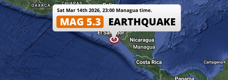
In the evening of Saturday March 14th, 2026, a significant M5.3 earthquake hit in the North Pacific Ocean 90 kilometer from San Miguel, El Salvador. Other countries near the epicenter include Nicaragua, Honduras and Guatemala.
Felt the earthquake? Share this article: 


Earthquake Summary
This earthquake hit under water in the North Pacific Ocean, 53 kilometers (33 mi) off the coast of El Salvador, 90 kilometer south of San Miguel. The center of this earthquake had a quite shallow depth of 60 km. Shallow earthquakes usually have a larger impact than earthquakes deep in the earth.
| Date and Time: | Mar 14, 2026 11:00PM (El Salvador Time) - Mar 15, 2026 05:00 Universal Time. |
|---|---|
| Location: | 90 km south of San Miguel, El Salvador. Coordinates 12°40'45"N 88°14'45"W. |
| Map: | 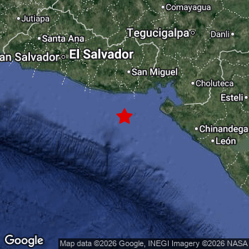 Map of area around epicenter. Click to open in Google Maps. |
| Magnitude: | MAG 5.3 Detected by 54 stations. Maximum Error Range ±0.042 . |
| Depth: | 60 km (37 mi) A quite shallow depth. |
| Tsunami Risk: | Low tsunami risk Earthquakes under MAG-6.5 do not usually cause tsunami's. Always stay cautious - More info here. |
Nearby towns and cities
This earthquake struck within proximity of multiple countries. El Salvador , Nicaragua , Honduras and Guatemala are all within 300km distance of its epicenter.
Located 75 kilometer (47 mi) south-east of the epicenter of this earthquake, Puerto El Triunfo (Usulután, El Salvador) is the nearest significant population center.
Major cities near this earthquake: Tegucigalpa is located 192 km to the north-east. Managua is located 225 km to the east. San Salvador is located 152 km to the northwest.
A complete list of nearby places is included below.
Overview of nearby places
| Distance | Place |
|---|---|
| 75 km (47 mi) NW from epicenter |
Puerto El Triunfo Usulután, El Salvador. |
| 78 km (48 mi) N from epicenter |
Usulután Usulután, El Salvador. |
| 79 km (49 mi) N from epicenter |
San Rafael Oriente San Miguel, El Salvador. |
| 85 km (53 mi) NE from epicenter |
La Unión La Unión, El Salvador. |
| 90 km (56 mi) N from epicenter |
San Miguel San Miguel, El Salvador. |
| 93 km (58 mi) N from epicenter |
Santiago de María Usulután, El Salvador. |
| 113 km (70 mi) NW from epicenter |
Zacatecoluca La Paz, El Salvador. |
| 115 km (71 mi) N from epicenter |
San Francisco Morazán, El Salvador. |
| 117 km (73 mi) E from epicenter |
El Viejo Chinandega, Nicaragua. |
| 118 km (73 mi) E from epicenter |
Corinto Chinandega, Nicaragua. |
| 120 km (75 mi) NE from epicenter |
San Lorenzo Valle, Honduras. |
| 121 km (75 mi) E from epicenter |
Chinandega Chinandega, Nicaragua. |
| 122 km (76 mi) NW from epicenter |
San Vicente San Vicente, El Salvador. |
| 133 km (83 mi) E from epicenter |
Chichigalpa Chinandega, Nicaragua. |
| 134 km (83 mi) NE from epicenter |
Ciudad Choluteca Choluteca, Honduras. |
| 137 km (85 mi) NW from epicenter |
Cojutepeque Cuscatlán, El Salvador. |
| 139 km (86 mi) N from epicenter |
Sensuntepeque Cabañas, El Salvador. |
| 143 km (89 mi) NW from epicenter |
San Martín Cuscatlán, El Salvador. |
| 147 km (91 mi) NW from epicenter |
Ilopango San Salvador, El Salvador. |
| 147 km (91 mi) NW from epicenter |
La Libertad La Libertad, El Salvador. |
| 149 km (93 mi) NW from epicenter |
San Marcos San Salvador, El Salvador. |
| 150 km (93 mi) NW from epicenter |
Soyapango San Salvador, El Salvador. |
| 151 km (94 mi) E from epicenter |
León León, Nicaragua. |
| 151 km (94 mi) E from epicenter |
Somotillo Chinandega, Nicaragua. |
| 152 km (94 mi) NW from epicenter |
San Salvador San Salvador, El Salvador. |
| 153 km (95 mi) NW from epicenter |
Delgado San Salvador, El Salvador. |
| 154 km (96 mi) NW from epicenter |
Cuscatancingo San Salvador, El Salvador. |
| 155 km (96 mi) NW from epicenter |
Antiguo Cuscatlán La Libertad, El Salvador. |
| 155 km (96 mi) NW from epicenter |
Mejicanos San Salvador, El Salvador. |
| 157 km (98 mi) NW from epicenter |
Ayutuxtepeque San Salvador, El Salvador. |
| 158 km (98 mi) NW from epicenter |
Santa Tecla La Libertad, El Salvador. |
| 161 km (100 mi) NW from epicenter |
Apopa San Salvador, El Salvador. |
| 168 km (104 mi) NW from epicenter |
Chalatenango Chalatenango, El Salvador. |
| 170 km (106 mi) NW from epicenter |
Quezaltepeque La Libertad, El Salvador. |
| 175 km (109 mi) E from epicenter |
La Paz Centro León, Nicaragua. |
| 175 km (109 mi) NW from epicenter |
Aguilares San Salvador, El Salvador. |
| 188 km (117 mi) E from epicenter |
Nagarote León, Nicaragua. |
| 192 km (119 mi) N from epicenter |
La Paz La Paz, Honduras. |
| 192 km (119 mi) NE from epicenter |
Tegucigalpa Francisco Morazán, Honduras. |
| 195 km (121 mi) NW from epicenter |
Izalco Sonsonate, El Salvador. |
| 197 km (122 mi) NW from epicenter |
Sonsonate Sonsonate, El Salvador. |
| 199 km (124 mi) NW from epicenter |
Acajutla Sonsonate, El Salvador. |
| 201 km (125 mi) NE from epicenter |
Somoto Madriz, Nicaragua. |
| 204 km (127 mi) NW from epicenter |
Santa Ana Santa Ana, El Salvador. |
| 208 km (129 mi) N from epicenter |
Comayagua Comayagua, Honduras. |
| 210 km (130 mi) E from epicenter |
Estelí Estelí, Nicaragua. |
| 214 km (133 mi) E from epicenter |
Ciudad Sandino Managua, Nicaragua. |
| 218 km (135 mi) N from epicenter |
Siguatepeque Comayagua, Honduras. |
| 219 km (136 mi) NE from epicenter |
Ocotal Nueva Segovia, Nicaragua. |
| 221 km (137 mi) NW from epicenter |
Ahuachapán Ahuachapán, El Salvador. |
| 225 km (140 mi) E from epicenter |
Managua Managua, Nicaragua. |
| 235 km (146 mi) NE from epicenter |
Danlí El Paraíso, Honduras. |
| 236 km (147 mi) E from epicenter |
Diriamba Carazo, Nicaragua. |
| 239 km (149 mi) N from epicenter |
Santa Rosa de Copán Copán, Honduras. |
| 247 km (153 mi) E from epicenter |
Jinotega Jinotega, Nicaragua. |
| 247 km (153 mi) E from epicenter |
Masaya Masaya, Nicaragua. |
| 249 km (155 mi) N from epicenter |
Santa Bárbara Santa Bárbara, Honduras. |
| 253 km (157 mi) NW from epicenter |
Jutiapa Jutiapa, Guatemala. |
| 254 km (158 mi) E from epicenter |
Matagalpa Matagalpa, Nicaragua. |
| 262 km (163 mi) E from epicenter |
Granada Granada, Nicaragua. |
| 274 km (170 mi) NW from epicenter |
Chiquimula Chiquimula, Guatemala. |
| 282 km (175 mi) E from epicenter |
Boaco Boaco, Nicaragua. |
| 288 km (179 mi) NW from epicenter |
Jalapa Jalapa, Guatemala. |
| 290 km (180 mi) NW from epicenter |
Zacapa Zacapa, Guatemala. |
| 292 km (181 mi) NW from epicenter |
Barberena Santa Rosa, Guatemala. |
| 294 km (183 mi) N from epicenter |
Villanueva Cortés, Honduras. |
| 297 km (185 mi) SE from epicenter |
Rivas Rivas, Nicaragua. |
| 299 km (186 mi) NE from epicenter |
Yoro Yoro, Honduras. |
Shaking reported by 8 people
People that feel an earthquake may report their experience to the US Geographic Survey. Currently, 8 people have reported shaking in 6 places, all within El Salvador.We keep updating this article as more ground reports become available. You may report that you felt this earthquake here.
Places with most reports:
- Antiguo Cuscatlán, La Libertad, El Salvador: 3 people.
- Chirilagua, San Miguel, El Salvador: 1 person.
- Usulután, Usulután, El Salvador: 1 person.
- Concepción de Ataco, Ahuachapán, El Salvador: 1 person.
- El Tránsito, San Miguel, El Salvador: 1 person.
- Delgado, San Salvador, El Salvador: 1 person.
10 Aftershocks detected
Since this main shock, 10 smaller aftershocks were detected. A 3.4 magnitude earthquake hit 2 days later 10 km (6 mi) south of this earthquake.
In the days before this main shock, 5 smaller foreshocks were detected. Nearby this earthquake a foreshock struck 2 days earlier. It measured a magnitude of 3.6
Overview of foreshocks and aftershocks
| Classification | Magnitude | When | Where |
|---|---|---|---|
| Foreshock | M 2.6 |
2 days earlier Mar 12, 2026 03:32PM (El Salvador Time) | 10 km (6 mi) SW from Main Shock. |
| Foreshock | M 3.6 |
2 days earlier Mar 12, 2026 10:12PM (El Salvador Time) | 18 km (11 mi) SW from Main Shock. |
| Foreshock | M 2.7 |
2 days earlier Mar 13, 2026 04:46AM (El Salvador Time) | 74 km (46 mi) SE from Main Shock. |
| Foreshock | M 2.7 |
1 day earlier Mar 13, 2026 07:55PM (El Salvador Time) | 71 km (44 mi) SE from Main Shock. |
| Foreshock | M 2.6 |
18 hrs earlier Mar 14, 2026 05:13AM (El Salvador Time) | 15 km (9 mi) NE from Main Shock. |
| Main Shock This Earthquake |
M 5.3 |
Mar 14, 2026 11:00PM (El Salvador Time) | - |
| Aftershock | M 2.8 |
27 mins later Mar 14, 2026 11:28PM (El Salvador Time) | 22 km (14 mi) SW from Main Shock. |
| Aftershock | M 2.6 |
9 hrs later Mar 15, 2026 07:58AM (El Salvador Time) | 17 km (10 mi) SW from Main Shock. |
| Aftershock | M 3.0 |
12 hrs later Mar 15, 2026 10:44AM (El Salvador Time) | 20 km (12 mi) SW from Main Shock. |
| Aftershock | M 2.8 |
23 hrs later Mar 15, 2026 10:01PM (El Salvador Time) | 42 km (26 mi) SW from Main Shock. |
| Aftershock | M 3.1 |
1 day later Mar 16, 2026 02:21AM (El Salvador Time) | 84 km (52 mi) SE from Main Shock. |
| Aftershock | M 2.8 |
1 day later Mar 16, 2026 02:27AM (El Salvador Time) | 61 km (38 mi) SE from Main Shock. |
| Aftershock | M 2.9 |
1 day later Mar 16, 2026 08:54AM (El Salvador Time) | 17 km (10 mi) SW from Main Shock. |
| Aftershock | M 3.4 |
2 days later Mar 16, 2026 04:14PM (El Salvador Time) | 10 km (6 mi) S from Main Shock. |
| Aftershock | M 2.7 |
3 days later Mar 17, 2026 01:23PM (El Salvador Time) | 40 km (25 mi) S from Main Shock. |
| Aftershock | M 2.8 |
3 days later Mar 17, 2026 05:28PM (El Salvador Time) | 10 km (6 mi) SE from Main Shock. |
More earthquakes coming?
The risk of aftershocks decreases rapidly over time. Usually, aftershocks are at least one order of magnitude lower than a main shock.
In only six percent of cases, significant earthquakes are followed by a larger main shock, making the current earthquake a foreshock. While the chance of this happening is not so large, it is adviced to maintain cautiousness in the hours and days following a major earthquake.
Read: How to Stay Safe during an Earthquake (cdc.gov).Earthquakes like this happen often in the region
Earthquakes of this strength are very common in the region. This is the strongest earthquake to hit since March 4th, 2026, when a 5.3 magnitude earthquake hit 14 km (8 mi) further southwest. An even stronger magnitude 6.9 earthquake struck on November 24th, 2016.
In total, 65 earthquakes with a magnitude of 5.3 or higher have been registered within 300km (186 mi) of this epicenter in the past 10 years. This comes down to an average of once every 2 months.
Low tsunami risk
Based on early data it appears this earthquake was not strong enough (lower than MAG-6.5) to be likely to cause destructive tsunami's. However this earthquake appeared to have hit at a shallow depth under sea, so stay cautious and monitor advice from local authorities.
Tsunami Risk Factors
| Factor | Under Sea? | MAG-6.5 or stronger? | Shallow depth? |
|---|---|---|---|
| Explanation | Almost all tsunami's are caused by earthquakes with their epicenter under sea or very near the sea. However stay cautious in coastal areas as earthquakes on land may cause landslides into sea, potentially still causing a local tsunami. | Under MAG 6.5: Very unlikely to cause a tsunami. MAG 6.5 to 7.5: Destructive tsunami's do occur, but are uncommon. Likely to observe small sea level changes. MAG 7.6+: Earthquakes with these magnitudes might produce destructive tsunami's. |
Most destructive tsunami's are caused by shallow earthquakes with a depth between 0 and 100km under the surface of the earth. Deeper tsunami's are unlikely to displace to ocean floor. |
| This Earthquake | This earthquake appears to have struck under the sea. | Not this earthquake. This earthquake had a magnitude of 5.3. Earthquakes of this strength are unlikely to trigger a tsunami. |
This earthquake occurred at a depth of of 60 km (37 mi). Earthquakes this shallow could trigger a tsunami. |
Sources
Last updated 01/04/26 00:58 (). This article contains currently available information about the earthquake and is automatically composed. We continue to update this article up to a few days after the earthquake occurred.
- US Geographic Society (USGS): Earthquake us6000sgea
- European-Mediterranean Seismological Centre (EMSC): Earthquake 20260315_0000075
- Geonames.org: World Cities Database
- Google Maps: Static API
- Earthquakelist.org: Historic Earthquakes Database
Share this article:
