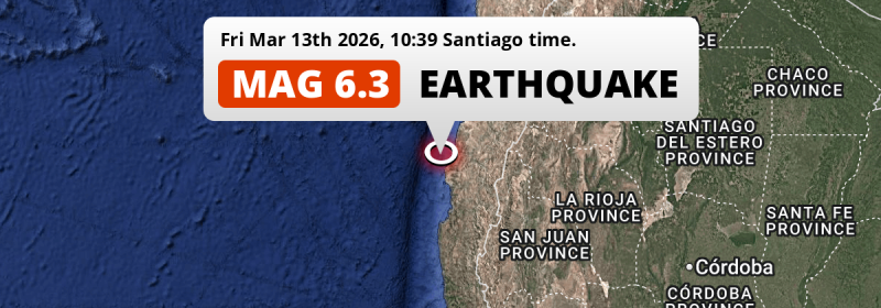
In the South Pacific Ocean 86 kilometer from Vallenar, Chile, a shallow and strong MAG-6.3 earthquake occurred in the morning of Friday March 13th, 2026. Shaking may have been felt by a total of 0.8 million people. Argentina is also near its epicenter.
Felt the earthquake? Share this article: 


Earthquake Summary
This earthquake hit under water in the South Pacific Ocean, 25 kilometers (15 mi) off the coast of Chile, 86 kilometer west of Vallenar in Atacama. The center of this earthquake had a very shallow depth of 10 km. Shallow earthquakes usually have a larger impact than earthquakes deep in the earth.
| Date and Time: | Mar 13, 2026 10:39 (Santiago Time) - Mar 13, 2026 13:39 Universal Time. |
|---|---|
| Location: | 86 km west of Vallenar, Atacama, Chile. Coordinates 28°41'2"S 71°37'37"W. |
| Map: | 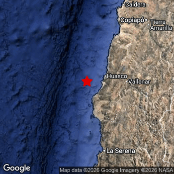 Map of area around epicenter. Click to open in Google Maps. |
| Magnitude: | MAG 6.3 Detected by 44 stations. Maximum Error Range ±0.047 . |
| Depth: | 10 km (6 mi) A very shallow depth. |
| Max. Intensity: | VI
Strong On the Modified Mercalli Scale. |
| Tsunami Risk: | Low tsunami risk Earthquakes under MAG-6.5 do not usually cause tsunami's. Always stay cautious - More info here. |
Minimal impact predicted
Based on scientific estimates by the US Geographic Survey (USGS), the risk of high fatalities for this earthquake is classified at level GREEN (low). They expect an 65% likelyhood of between 0 and 1 fatalities, and a 96% chance that the number of fatalities falls no higher than 10.
The USGS classifies the economic impact of this earthquake at level GREEN (low). They expect an 68% likelyhood of between 0 and 1 million US Dollars in economic damage and impact, and a 98% chance that the economic impact of this earthquake falls no higher than 10 million USD.
Roughly 0.8 million people exposed to shaking
This earthquake may have been felt by around 0.8 million people. That is the expected population size of the area exposed to a level of shaking of II or higher on the Modified Mercalli scale according to the USGS.
Strong shaking and probably light damage may have been experienced by an estimated 610 people. At VI, it is the highest MMI level this earthquake has caused. Intensity level IV was experienced by the majority of people (around 660 thousand). In their region, light shaking and likely no damage can be expected.
People in 2 countries have been exposed to shaking. In Chile , around 0.8 million people, with impact levels up to VI (strong shaking, probably light damage). Shaking was experienced by inhabitants of Argentina too.
| People | MMI Level | Shaking | Damage |
|---|---|---|---|
| 0 | I |
Not noticable | None |
| 0 | II |
Very weak | None |
| 169,200 | III |
Weak | Probably none |
| 658,000 | IV |
Light | Likely none |
| 11,760 | V |
Moderate | Very light |
| 610 | VI |
Strong | Light |
| 0 | VII |
Very Strong | Moderate |
| 0 | VIII |
Severe | Moderate to heavy |
| 0 | IX |
Violent | Heavy |
| 0 | X |
Extreme | Very heavy |
Nearby towns and cities
Chile and Argentina are both located within 300km distance of the epicenter of the earthquake.
Located 86 kilometer (53 mi) west of the epicenter of this earthquake, Vallenar (Atacama, Chile) is the nearest significant population center. Vallenar experienced an earthquake intensity (MMI Scale) of roughly IV. That level implies light shaking and likely no damage.
Multiple major population centers exist within 300km of the earthquake that struck today. Coquimbo is located 144 km to the south and experienced an intensity of IV (light shaking, likely no damage). La Serena is located 141 km to the south and experienced an intensity of IV (light shaking, likely no damage). Copiapó is located 194 km to the north-east and experienced an intensity of IV (light shaking, likely no damage).
The table below provides an overview of all places in proximity of today's earthquake. Where available, the estimated intensity on the Modified Mercalli Intensity Scale in each place is included. Places where this information is omitted likely experienced little impact.
Overview of nearby places
| Distance | Place | Intensity (MMI) |
|---|---|---|
| 86 km (53 mi) E from epicenter |
Vallenar Atacama, Chile. |
IV
Light |
| 141 km (88 mi) S from epicenter |
La Serena Coquimbo Region, Chile. |
IV
Light |
| 144 km (89 mi) S from epicenter |
Coquimbo Coquimbo Region, Chile. |
IV
Light |
| 194 km (121 mi) NE from epicenter |
Copiapó Atacama, Chile. |
IV
Light |
| 217 km (135 mi) S from epicenter |
Ovalle Coquimbo Region, Chile. |
|
| 299 km (186 mi) NE from epicenter |
Diego de Almagro Atacama, Chile. |
|
| 328 km (204 mi) SE from epicenter |
San José de Jáchal San Juan, Argentina. |
|
| 331 km (206 mi) S from epicenter |
Illapel Coquimbo Region, Chile. |
Earthquake Intensity Map
The maximum intensity (MMI Scale) caused by this earthquake is VI. The map below shows in which areas this earthquake was the most and least impactful. It is based on data from the US Geographic Survey.

Shaking reported by 33 people in 2 countries
People that feel an earthquake may report their experience to the US Geographic Survey. Currently, 33 people have reported shaking in 11 places in 2 countries (Chile, Argentina).We keep updating this article as more ground reports become available. You may report that you felt this earthquake here.
Places with most reports:
- Santiago, Metropolitana, Chile: 8 people.
- La Serena, Coquimbo, Chile: 7 people.
- Vallenar, Atacama, Chile: 5 people.
- Coquimbo, Coquimbo, Chile: 3 people.
- Viña del Mar, Valparaíso, Chile: 2 people.
- Lampa, Metropolitana, Chile: 2 people.
- Mendoza, Mendoza, Argentina: 2 people.
- La Rioja, La Rioja, Argentina: 1 person.
- Valparaíso, Valparaíso, Chile: 1 person.
- San Juan, San Juan, Argentina: 1 person.
65 Aftershocks detected
After this earthquake struck, 65 smaller aftershocks occurred. At a distance of 21 km (13 mi) east of this earthquake, an aftershock struck 3 days later. It measured a magnitude of 4
This main shock was prefaced by 3 smaller foreshocks. A 4.2 magnitude earthquake hit 3 days earlier nearby.
Overview of foreshocks and aftershocks
| Classification | Magnitude | When | Where |
|---|---|---|---|
| Foreshock | M 4.2 |
3 days earlier Mar 10, 2026 11:46 (Santiago Time) | 91 km (57 mi) SE from Main Shock. |
| Foreshock | M 2.6 |
10 hrs earlier Mar 13, 2026 00:48 (Santiago Time) | 24 km (15 mi) SE from Main Shock. |
| Foreshock | M 2.5 |
5 hrs earlier Mar 13, 2026 06:06 (Santiago Time) | 91 km (56 mi) S from Main Shock. |
| Main Shock This Earthquake |
M 6.3 |
Mar 13, 2026 10:39 (Santiago Time) | - |
| Aftershock | M 3.6 |
4 mins later Mar 13, 2026 10:43 (Santiago Time) | 23 km (15 mi) SE from Main Shock. |
| Aftershock | M 3.3 |
7 mins later Mar 13, 2026 10:46 (Santiago Time) | 30 km (19 mi) SE from Main Shock. |
| Aftershock | M 3.4 |
8 mins later Mar 13, 2026 10:47 (Santiago Time) | 27 km (16 mi) SE from Main Shock. |
| Aftershock | M 4.0 |
10 mins later Mar 13, 2026 10:49 (Santiago Time) | 19 km (12 mi) SE from Main Shock. |
| Aftershock | M 3.8 |
11 mins later Mar 13, 2026 10:50 (Santiago Time) | 20 km (13 mi) E from Main Shock. |
| Aftershock | M 3.4 |
13 mins later Mar 13, 2026 10:52 (Santiago Time) | 25 km (15 mi) SE from Main Shock. |
| Aftershock | M 2.6 |
14 mins later Mar 13, 2026 10:53 (Santiago Time) | 30 km (18 mi) SE from Main Shock. |
| Aftershock | M 3.8 |
17 mins later Mar 13, 2026 10:56 (Santiago Time) | 22 km (13 mi) SE from Main Shock. |
| Aftershock | M 2.9 |
22 mins later Mar 13, 2026 11:01 (Santiago Time) | 29 km (18 mi) SE from Main Shock. |
| Aftershock | M 2.8 |
27 mins later Mar 13, 2026 11:05 (Santiago Time) | 29 km (18 mi) E from Main Shock. |
| Aftershock | M 2.5 |
30 mins later Mar 13, 2026 11:09 (Santiago Time) | 32 km (20 mi) SE from Main Shock. |
| Aftershock | M 3.3 |
37 mins later Mar 13, 2026 11:16 (Santiago Time) | 18 km (11 mi) SE from Main Shock. |
| Aftershock | M 3.0 |
41 mins later Mar 13, 2026 11:19 (Santiago Time) | 25 km (16 mi) SE from Main Shock. |
| Aftershock | M 3.2 |
50 mins later Mar 13, 2026 11:29 (Santiago Time) | 23 km (14 mi) SE from Main Shock. |
| Aftershock | M 3.6 |
53 mins later Mar 13, 2026 11:32 (Santiago Time) | 17 km (11 mi) SE from Main Shock. |
| Aftershock | M 3.7 |
1 hr later Mar 13, 2026 11:47 (Santiago Time) | 31 km (19 mi) SE from Main Shock. |
| Aftershock | M 3.3 |
1 hr later Mar 13, 2026 11:58 (Santiago Time) | 23 km (14 mi) SE from Main Shock. |
| Aftershock | M 2.6 |
2 hrs later Mar 13, 2026 12:53 (Santiago Time) | 21 km (13 mi) SE from Main Shock. |
| Aftershock | M 3.4 |
2 hrs later Mar 13, 2026 13:07 (Santiago Time) | 29 km (18 mi) SE from Main Shock. |
| Aftershock | M 2.6 |
3 hrs later Mar 13, 2026 13:28 (Santiago Time) | 28 km (17 mi) SE from Main Shock. |
| Aftershock | M 3.4 |
4 hrs later Mar 13, 2026 15:03 (Santiago Time) | 27 km (17 mi) SE from Main Shock. |
| Aftershock | M 3.1 |
4 hrs later Mar 13, 2026 15:06 (Santiago Time) | 23 km (14 mi) E from Main Shock. |
| Aftershock | M 2.7 |
5 hrs later Mar 13, 2026 15:10 (Santiago Time) | 30 km (19 mi) E from Main Shock. |
| Aftershock | M 2.9 |
6 hrs later Mar 13, 2026 16:10 (Santiago Time) | 25 km (16 mi) SE from Main Shock. |
| Aftershock | M 2.8 |
6 hrs later Mar 13, 2026 16:58 (Santiago Time) | 23 km (14 mi) SE from Main Shock. |
| Aftershock | M 3.1 |
6 hrs later Mar 13, 2026 16:59 (Santiago Time) | 30 km (19 mi) E from Main Shock. |
| Aftershock | M 2.8 |
7 hrs later Mar 13, 2026 17:14 (Santiago Time) | 24 km (15 mi) SE from Main Shock. |
| Aftershock | M 2.7 |
7 hrs later Mar 13, 2026 17:17 (Santiago Time) | 20 km (12 mi) SE from Main Shock. |
| Aftershock | M 3.2 |
7 hrs later Mar 13, 2026 17:36 (Santiago Time) | 23 km (14 mi) SE from Main Shock. |
| Aftershock | M 2.5 |
8 hrs later Mar 13, 2026 18:21 (Santiago Time) | 21 km (13 mi) SE from Main Shock. |
| Aftershock | M 2.8 |
8 hrs later Mar 13, 2026 19:04 (Santiago Time) | 28 km (18 mi) SE from Main Shock. |
| Aftershock | M 2.9 |
9 hrs later Mar 13, 2026 19:17 (Santiago Time) | 24 km (15 mi) E from Main Shock. |
| Aftershock | M 2.8 |
9 hrs later Mar 13, 2026 19:40 (Santiago Time) | 22 km (13 mi) SE from Main Shock. |
| Aftershock | M 2.9 |
9 hrs later Mar 13, 2026 19:52 (Santiago Time) | 24 km (15 mi) SE from Main Shock. |
| Aftershock | M 3.6 |
11 hrs later Mar 13, 2026 22:08 (Santiago Time) | 23 km (14 mi) E from Main Shock. |
| Aftershock | M 2.5 |
13 hrs later Mar 14, 2026 00:07 (Santiago Time) | 21 km (13 mi) SE from Main Shock. |
| Aftershock | M 3.9 |
14 hrs later Mar 14, 2026 00:24 (Santiago Time) | 21 km (13 mi) SE from Main Shock. |
| Aftershock | M 4.0 |
14 hrs later Mar 14, 2026 00:31 (Santiago Time) | 32 km (20 mi) E from Main Shock. |
| Aftershock | M 3.3 |
15 hrs later Mar 14, 2026 01:10 (Santiago Time) | 19 km (12 mi) E from Main Shock. |
| Aftershock | M 3.7 |
15 hrs later Mar 14, 2026 01:14 (Santiago Time) | 23 km (14 mi) SE from Main Shock. |
| Aftershock | M 2.5 |
15 hrs later Mar 14, 2026 01:33 (Santiago Time) | 26 km (16 mi) E from Main Shock. |
| Aftershock | M 2.8 |
15 hrs later Mar 14, 2026 01:40 (Santiago Time) | 16 km (10 mi) SE from Main Shock. |
| Aftershock | M 2.6 |
15 hrs later Mar 14, 2026 01:52 (Santiago Time) | 27 km (17 mi) E from Main Shock. |
| Aftershock | M 2.5 |
15 hrs later Mar 14, 2026 02:03 (Santiago Time) | 23 km (14 mi) E from Main Shock. |
| Aftershock | M 2.6 |
18 hrs later Mar 14, 2026 04:36 (Santiago Time) | 41 km (26 mi) SE from Main Shock. |
| Aftershock | M 2.8 |
24 hrs later Mar 14, 2026 10:33 (Santiago Time) | 23 km (15 mi) SE from Main Shock. |
| Aftershock | M 2.8 |
1 day later Mar 14, 2026 11:07 (Santiago Time) | 22 km (13 mi) SE from Main Shock. |
| Aftershock | M 3.6 |
1 day later Mar 14, 2026 15:52 (Santiago Time) | 26 km (16 mi) SE from Main Shock. |
| Aftershock | M 3.1 |
1 day later Mar 14, 2026 16:15 (Santiago Time) | 24 km (15 mi) SE from Main Shock. |
| Aftershock | M 3.4 |
1 day later Mar 14, 2026 18:34 (Santiago Time) | 24 km (15 mi) SE from Main Shock. |
| Aftershock | M 2.7 |
1 day later Mar 14, 2026 18:52 (Santiago Time) | 21 km (13 mi) E from Main Shock. |
| Aftershock | M 3.1 |
2 days later Mar 14, 2026 23:28 (Santiago Time) | 22 km (13 mi) SE from Main Shock. |
| Aftershock | M 2.6 |
2 days later Mar 15, 2026 00:24 (Santiago Time) | 34 km (21 mi) S from Main Shock. |
| Aftershock | M 2.8 |
2 days later Mar 15, 2026 00:31 (Santiago Time) | 41 km (26 mi) NE from Main Shock. |
| Aftershock | M 2.7 |
2 days later Mar 15, 2026 02:12 (Santiago Time) | 22 km (14 mi) SE from Main Shock. |
| Aftershock | M 3.4 |
2 days later Mar 15, 2026 04:57 (Santiago Time) | 15 km (9 mi) S from Main Shock. |
| Aftershock | M 2.8 |
2 days later Mar 15, 2026 13:35 (Santiago Time) | 25 km (16 mi) SE from Main Shock. |
| Aftershock | M 3.2 |
2 days later Mar 15, 2026 16:05 (Santiago Time) | 29 km (18 mi) SE from Main Shock. |
| Aftershock | M 3.6 |
2 days later Mar 15, 2026 17:30 (Santiago Time) | 29 km (18 mi) E from Main Shock. |
| Aftershock | M 3.3 |
2 days later Mar 15, 2026 20:16 (Santiago Time) | 11 km (7 mi) S from Main Shock. |
| Aftershock | M 2.5 |
3 days later Mar 16, 2026 01:42 (Santiago Time) | 86 km (54 mi) E from Main Shock. |
| Aftershock | M 4.0 |
3 days later Mar 16, 2026 02:23 (Santiago Time) | 21 km (13 mi) E from Main Shock. |
| Aftershock | M 2.8 |
3 days later Mar 16, 2026 03:16 (Santiago Time) | 42 km (26 mi) S from Main Shock. |
| Aftershock | M 2.9 |
3 days later Mar 16, 2026 06:16 (Santiago Time) | 33 km (20 mi) E from Main Shock. |
| Aftershock | M 3.3 |
3 days later Mar 16, 2026 10:36 (Santiago Time) | 22 km (13 mi) E from Main Shock. |
More earthquakes coming?
Earthquakes can create aftershocks. These are generally at least 1 magnitude lower than any main shock, and as time passes the chance and strength of aftershocks decreases.
It's always adviced to be cautious of the risk of a larger shock following any significant earthquake, however this risk is fairly small. There is a roughly 94 percent change that no larger main shock will follow in the days following this earthquake.
Read: How to Stay Safe during an Earthquake (cdc.gov).Earthquakes like this are common in the region
Earthquakes of this strength occur quite regularly in the region. This is the strongest earthquake to hit since June 6th, 2025, when a 6.4 magnitude earthquake hit 257 km (160 mi) further north-east. An even stronger magnitude 6.8 earthquake struck on September 1st, 2020.
In total, 11 earthquakes with a magnitude of 6.3 or higher have been registered within 300km (186 mi) of this epicenter in the past 10 years. This comes down to an average of once every year.
Low tsunami risk
Based on early data it appears this earthquake was not strong enough (lower than MAG-6.5) to be likely to cause destructive tsunami's. However this earthquake appeared to have hit at a shallow depth under sea, so stay cautious and monitor advice from local authorities.
Tsunami Risk Factors
| Factor | Under Sea? | MAG-6.5 or stronger? | Shallow depth? |
|---|---|---|---|
| Explanation | Almost all tsunami's are caused by earthquakes with their epicenter under sea or very near the sea. However stay cautious in coastal areas as earthquakes on land may cause landslides into sea, potentially still causing a local tsunami. | Under MAG 6.5: Very unlikely to cause a tsunami. MAG 6.5 to 7.5: Destructive tsunami's do occur, but are uncommon. Likely to observe small sea level changes. MAG 7.6+: Earthquakes with these magnitudes might produce destructive tsunami's. |
Most destructive tsunami's are caused by shallow earthquakes with a depth between 0 and 100km under the surface of the earth. Deeper tsunami's are unlikely to displace to ocean floor. |
| This Earthquake | This earthquake appears to have struck under the sea. | Not this earthquake. This earthquake had a magnitude of 6.3. Earthquakes of this strength are unlikely to trigger a tsunami. |
This earthquake occurred at a depth of of 10 km (6 mi). Earthquakes this shallow could trigger a tsunami. |
Sources
Last updated 01/04/26 01:48 (). This article contains currently available information about the earthquake and is automatically composed. We continue to update this article up to a few days after the earthquake occurred.
- US Geographic Society (USGS): Earthquake us6000sg0y
- European-Mediterranean Seismological Centre (EMSC): Earthquake 20260313_0000254
- Geonames.org: World Cities Database
- Google Maps: Static API
- Earthquakelist.org: Historic Earthquakes Database
Share this article:
