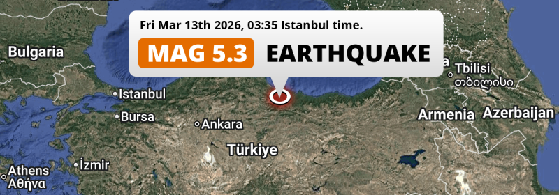
Deep in the night of Friday March 13th, 2026, a shallow and significant M5.3 earthquake hit under land 17 kilometer from Erbaa in Türkiye.
Felt the earthquake? Share this article: 


Earthquake Summary
The earthquake struck on land in Türkiye, 17 kilometer (11 mi) east of Erbaa in Tokat. The center of this earthquake had a very shallow depth of 10 km. Shallow earthquakes usually have a larger impact than earthquakes deep in the earth.
| Date and Time: | Mar 13, 2026 03:35 (Istanbul Time) - Mar 13, 2026 00:35 Universal Time. |
|---|---|
| Location: | 17 km east of Erbaa, Tokat, Türkiye. Coordinates 40°41'36"N 36°45'51"E. |
| Map: | 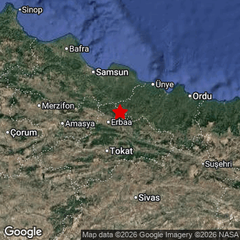 Map of area around epicenter. Click to open in Google Maps. |
| Magnitude: | MAG 5.3 Detected by 31 stations. Maximum Error Range ±0.056 . |
| Depth: | 10 km (6 mi) A very shallow depth. |
| Max. Intensity: | VII
Very Strong On the Modified Mercalli Scale. |
| Tsunami Risk: | Tsunami very unlikely While this was a shallow earthquake, it appears to have occurred under land with a magnitude not strong enough to cause tsunami's. Always stay cautious - More info here. |
Nearby towns and cities
This earthquake may have been felt in Türkiye . Erbaa in Tokat, Türkiye is the nearest significant place from the epicenter. The earthquake occurred 17 kilometer (11 mi) east of Erbaa. Erbaa experienced an earthquake intensity (MMI Scale) of roughly V. That level implies moderate shaking and very light damage.
Multiple major population centers exist within 300km of the earthquake that struck today. Samsun is located 74 km to the northwest and experienced an intensity of III (weak shaking, probably no damage). Tokat is located 46 km to the south and experienced an intensity of IV (light shaking, likely no damage). Sivas is located 107 km to the south and experienced an intensity of III (weak shaking, probably no damage).
An overview of nearby towns and cities is available in the overview below. If places don't have intensity data available, it likely means the experienced impact in those places was fairly small.
Overview of nearby places
| Distance | Place | Intensity (MMI) |
|---|---|---|
| 17 km (11 mi) W from epicenter |
Erbaa Tokat, Türkiye. |
V
Moderate |
| 19 km (12 mi) SE from epicenter |
Niksar Tokat, Türkiye. |
IV
Light |
| 38 km (24 mi) W from epicenter |
Taşova Amasya, Türkiye. |
IV
Light |
| 46 km (29 mi) S from epicenter |
Tokat Tokat, Türkiye. |
IV
Light |
| 47 km (29 mi) NE from epicenter |
Kumru Ordu, Türkiye. |
IV
Light |
| 51 km (32 mi) E from epicenter |
Korgan Ordu, Türkiye. |
IV
Light |
| 56 km (35 mi) N from epicenter |
Çarşamba Samsun, Türkiye. |
IV
Light |
| 60 km (37 mi) N from epicenter |
Terme Samsun, Türkiye. |
IV
Light |
| 63 km (39 mi) NW from epicenter |
Tekkeköy Samsun, Türkiye. |
III
Weak |
| 65 km (40 mi) NE from epicenter |
Ünye Ordu, Türkiye. |
IV
Light |
| 67 km (42 mi) SW from epicenter |
Turhal Tokat, Türkiye. |
IV
Light |
| 70 km (43 mi) E from epicenter |
Gürgentepe Ordu, Türkiye. |
III
Weak |
| 72 km (45 mi) NE from epicenter |
Fatsa Ordu, Türkiye. |
III
Weak |
| 74 km (46 mi) NW from epicenter |
Samsun Samsun, Türkiye. |
III
Weak |
| 79 km (49 mi) W from epicenter |
Amasya Amasya, Türkiye. |
III
Weak |
| 86 km (53 mi) SW from epicenter |
Zile Tokat, Türkiye. |
III
Weak |
| 95 km (59 mi) W from epicenter |
Suluova Amasya, Türkiye. |
III
Weak |
| 98 km (61 mi) W from epicenter |
Havza Samsun, Türkiye. |
III
Weak |
| 100 km (62 mi) E from epicenter |
Ordu Ordu, Türkiye. |
III
Weak |
| 107 km (66 mi) S from epicenter |
Sivas Sivas, Türkiye. |
III
Weak |
| 111 km (69 mi) W from epicenter |
Merzifon Amasya, Türkiye. |
III
Weak |
| 121 km (75 mi) NW from epicenter |
Bafra Samsun, Türkiye. |
III
Weak |
| 121 km (75 mi) NW from epicenter |
Vezirköprü Samsun, Türkiye. |
III
Weak |
| 126 km (78 mi) SE from epicenter |
Suşehri Sivas, Türkiye. |
III
Weak |
| 126 km (78 mi) E from epicenter |
Bulancak Giresun, Türkiye. |
III
Weak |
| 137 km (85 mi) SW from epicenter |
Akdağmadeni Yozgat, Türkiye. |
III
Weak |
| 139 km (86 mi) E from epicenter |
Giresun Giresun, Türkiye. |
III
Weak |
| 147 km (91 mi) E from epicenter |
Şebin Karahisar Giresun, Türkiye. |
III
Weak |
| 152 km (94 mi) S from epicenter |
Şarkışla Sivas, Türkiye. |
III
Weak |
| 154 km (96 mi) W from epicenter |
Çorum Çorum, Türkiye. |
III
Weak |
| 166 km (103 mi) SW from epicenter |
Sorgun Yozgat, Türkiye. |
III
Weak |
| 166 km (103 mi) E from epicenter |
Espiye Giresun, Türkiye. |
II
Weak |
| 168 km (104 mi) W from epicenter |
Osmancık Çorum, Türkiye. |
III
Weak |
| 173 km (107 mi) W from epicenter |
Alaca Çorum, Türkiye. |
III
Weak |
| 176 km (109 mi) E from epicenter |
Tirebolu Giresun, Türkiye. |
II
Weak |
| 178 km (111 mi) S from epicenter |
Gemerek Sivas, Türkiye. |
II
Weak |
| 188 km (117 mi) NW from epicenter |
Boyabat Sinop, Türkiye. |
II
Weak |
| 192 km (119 mi) E from epicenter |
Görele Giresun, Türkiye. |
II
Weak |
| 193 km (120 mi) W from epicenter |
İskilip Çorum, Türkiye. |
II
Weak |
| 193 km (120 mi) SW from epicenter |
Yozgat Yozgat, Türkiye. |
II
Weak |
| 200 km (124 mi) NW from epicenter |
Sinop Sinop, Türkiye. |
II
Weak |
| 230 km (143 mi) E from epicenter |
Gümüşhane Gümüşhane, Türkiye. |
|
| 244 km (152 mi) SW from epicenter |
Kayseri Kayseri, Türkiye. |
|
| 252 km (157 mi) E from epicenter |
Trabzon Trabzon, Türkiye. |
|
| 255 km (158 mi) SE from epicenter |
Erzincan Erzincan, Türkiye. |
|
| 262 km (163 mi) W from epicenter |
Kastamonu Kastamonu, Türkiye. |
|
| 266 km (165 mi) W from epicenter |
Çankırı Çankırı, Türkiye. |
|
| 279 km (173 mi) S from epicenter |
Elbistan Kahramanmaraş, Türkiye. |
|
| 281 km (175 mi) SW from epicenter |
Kırşehir Kırşehir, Türkiye. |
|
| 289 km (180 mi) SW from epicenter |
Nevşehir Nevşehir, Türkiye. |
|
| 292 km (181 mi) W from epicenter |
Kırıkkale Kırıkkale, Türkiye. |
|
| 293 km (182 mi) SE from epicenter |
Malatya Malatya, Türkiye. |
|
| 294 km (183 mi) SE from epicenter |
Baskil Elazığ, Türkiye. |
|
| 296 km (184 mi) SE from epicenter |
Tunceli Tunceli, Türkiye. |
|
| 297 km (185 mi) E from epicenter |
Bayburt Bayburt, Türkiye. |
Earthquake Intensity Map
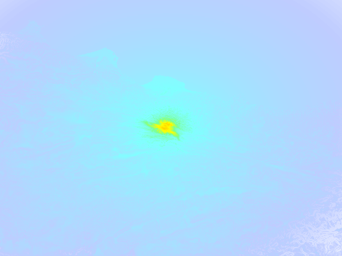
The graph below overlays a map of the region around the epicenter with earthquake intensity data provided by the US Geographic Survey. The highest intensity level detected for this earthquake is VII.
Shaking reported by 8 people
People that feel an earthquake may report their experience to the US Geographic Survey. Currently, 8 people have reported shaking in 5 places, all within Turkey.We keep updating this article as more ground reports become available. You may report that you felt this earthquake here.
Places with most reports:
- Samsun, Samsun, Turkey: 3 people.
- Ordu, Ordu, Turkey: 2 people.
- Erbaa, Tokat, Turkey: 1 person.
- Tirebolu, Giresun, Turkey: 1 person.
- Kayseri, Kayseri, Turkey: 1 person.
20 Aftershocks detected
Since this main shock, 20 smaller aftershocks were detected. Just 13 hrs after this main shock, an earthquake measuring MAG-3.6 was detected 5 km (3 mi) south-east of this earthquake.
Overview of foreshocks and aftershocks
| Classification | Magnitude | When | Where |
|---|---|---|---|
| Main Shock This Earthquake |
M 5.3 |
Mar 13, 2026 03:35 (Istanbul Time) | - |
| Aftershock | M 2.5 |
5 mins later Mar 13, 2026 03:40 (Istanbul Time) | 6 km (4 mi) SE from Main Shock. |
| Aftershock | M 3.4 |
12 mins later Mar 13, 2026 03:47 (Istanbul Time) | 4 km (2.7 mi) SE from Main Shock. |
| Aftershock | M 2.6 |
29 mins later Mar 13, 2026 04:04 (Istanbul Time) | 6 km (4 mi) SE from Main Shock. |
| Aftershock | M 2.9 |
43 mins later Mar 13, 2026 04:18 (Istanbul Time) | 5 km (3 mi) S from Main Shock. |
| Aftershock | M 2.9 |
1 hr later Mar 13, 2026 05:03 (Istanbul Time) | 5 km (2.8 mi) S from Main Shock. |
| Aftershock | M 2.9 |
2 hrs later Mar 13, 2026 05:06 (Istanbul Time) | 6 km (4 mi) SE from Main Shock. |
| Aftershock | M 2.6 |
2 hrs later Mar 13, 2026 05:19 (Istanbul Time) | 5 km (2.9 mi) SE from Main Shock. |
| Aftershock | M 2.5 |
2 hrs later Mar 13, 2026 05:24 (Istanbul Time) | 6 km (4 mi) S from Main Shock. |
| Aftershock | M 2.5 |
3 hrs later Mar 13, 2026 06:45 (Istanbul Time) | 7 km (4 mi) SE from Main Shock. |
| Aftershock | M 2.6 |
8 hrs later Mar 13, 2026 11:06 (Istanbul Time) | 5 km (2.9 mi) SE from Main Shock. |
| Aftershock | M 2.6 |
10 hrs later Mar 13, 2026 13:08 (Istanbul Time) | 4 km (2.7 mi) SE from Main Shock. |
| Aftershock | M 2.7 |
11 hrs later Mar 13, 2026 15:04 (Istanbul Time) | 6 km (4 mi) SE from Main Shock. |
| Aftershock | M 3.6 |
13 hrs later Mar 13, 2026 16:58 (Istanbul Time) | 5 km (3 mi) SE from Main Shock. |
| Aftershock | M 2.9 |
20 hrs later Mar 13, 2026 23:28 (Istanbul Time) | 5 km (3 mi) SE from Main Shock. |
| Aftershock | M 2.7 |
24 hrs later Mar 14, 2026 03:27 (Istanbul Time) | 2 km (1.2 mi) S from Main Shock. |
| Aftershock | M 3.4 |
1 day later Mar 14, 2026 05:50 (Istanbul Time) | 3 km (1.9 mi) SE from Main Shock. |
| Aftershock | M 2.9 |
1 day later Mar 14, 2026 14:14 (Istanbul Time) | 6 km (4 mi) S from Main Shock. |
| Aftershock | M 2.8 |
2 days later Mar 14, 2026 20:46 (Istanbul Time) | 6 km (4 mi) S from Main Shock. |
| Aftershock | M 2.9 |
2 days later Mar 15, 2026 00:03 (Istanbul Time) | 6 km (4 mi) SE from Main Shock. |
| Aftershock | M 2.5 |
3 days later Mar 16, 2026 02:10 (Istanbul Time) | 5 km (3 mi) S from Main Shock. |
More earthquakes coming?
Aftershocks are usually at least 1 order of magnitude less strong than main shocks. The more time passes, the smaller the chance and likely strength of any potential aftershocks.
In only six percent of cases, significant earthquakes are followed by a larger main shock, making the current earthquake a foreshock. While the chance of this happening is not so large, it is adviced to maintain cautiousness in the hours and days following a major earthquake.
Read: How to Stay Safe during an Earthquake (cdc.gov).Earthquakes like this are common in the region
Earthquakes of this strength occur quite regularly in the region. This is the strongest earthquake to hit since April 18th, 2024, when a 5.6 magnitude earthquake hit 105 km (65 mi) further southwest. An even stronger magnitude 6 earthquake struck on February 6th, 2023.
In total, 4 earthquakes with a magnitude of 5.3 or higher have been registered within 300km (186 mi) of this epicenter in the past 10 years. This comes down to an average of once every 3 years.
Tsunami very unlikely
While MAG-6.5+ earthquakes may cause tsunami's, it appears that the epicenter of this earthquake hit under land. In addition, the reported depth is deeper than 100km, making the risk of a tsunami even less likely. However always stay cautious and monitor advice from local authorities.
Tsunami Risk Factors
| Factor | Under Sea? | MAG-6.5 or stronger? | Shallow depth? |
|---|---|---|---|
| Explanation | Almost all tsunami's are caused by earthquakes with their epicenter under sea or very near the sea. However stay cautious in coastal areas as earthquakes on land may cause landslides into sea, potentially still causing a local tsunami. | Under MAG 6.5: Very unlikely to cause a tsunami. MAG 6.5 to 7.5: Destructive tsunami's do occur, but are uncommon. Likely to observe small sea level changes. MAG 7.6+: Earthquakes with these magnitudes might produce destructive tsunami's. |
Most destructive tsunami's are caused by shallow earthquakes with a depth between 0 and 100km under the surface of the earth. Deeper tsunami's are unlikely to displace to ocean floor. |
| This Earthquake | Not this earthquake. This earthquake appears to have struck on land far from any coast. |
Not this earthquake. This earthquake had a magnitude of 5.3. Earthquakes of this strength are unlikely to trigger a tsunami. |
This earthquake occurred at a depth of of 10 km (6 mi). Earthquakes this shallow could trigger a tsunami. |
Sources
Last updated 01/04/26 02:18 (). This article is automatically generated based on available data. We keep checking multiple sources for additional information. This article gets updated as new details on this earthquake become available.
- US Geographic Society (USGS): Earthquake us6000sfyj
- European-Mediterranean Seismological Centre (EMSC): Earthquake 20260313_0000005
- Geonames.org: World Cities Database
- Google Maps: Static API
- Earthquakelist.org: Historic Earthquakes Database
Share this article:
