A shallow and significant MAG-5.0 earthquake struck in the North Pacific Ocean 187 kilometer from Morioka, Japan in the night of Saturday March 14th, 2026.
Felt the earthquake? Share this article: 


Earthquake Summary
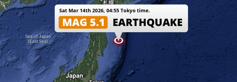
This earthquake hit under water in the North Pacific Ocean, 138 kilometers (86 mi) off the coast of Japan, 187 kilometer east of Morioka in Iwate. The center of this earthquake had a quite shallow depth of 26 km. Shallow earthquakes usually have a larger impact than earthquakes deep in the earth.
| Date and Time: | Mar 14, 2026 04:55 (Tokyo Time) - Mar 13, 2026 19:55 Universal Time. |
|---|---|
| Location: | 187 km east of Morioka, Iwate, Japan. Coordinates 39°23'9"N 143°17'50"E. |
| Map: | 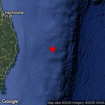 Map of area around epicenter. Click to open in Google Maps. |
| Magnitude: | MAG 5.0 Detected by 20 stations. Maximum Error Range ±0.069 . |
| Depth: | 26 km (16 mi) A quite shallow depth. |
| Tsunami Risk: | Low tsunami risk Earthquakes under MAG-6.5 do not usually cause tsunami's. Always stay cautious - More info here. |
Nearby towns and cities
This earthquake may have been felt in Japan . The closest significant population center near the earthquake is Yamada in Iwate, Japan. Yamada is located 116 kilometer (72 mi) east of the epicenter.
Multiple large cities are in proximity of today's earthquake. Sendai is located 245 km to the southwest. Morioka is located 187 km to the west. Hachinohe is located 197 km to the northwest.
The table below provides an overview of all places in proximity of today's earthquake.
Overview of nearby places
| Distance | Place |
|---|---|
| 116 km (72 mi) W from epicenter |
Yamada Iwate, Japan. |
| 120 km (75 mi) W from epicenter |
Miyako Iwate, Japan. |
| 124 km (77 mi) W from epicenter |
Kamaishi Iwate, Japan. |
| 141 km (88 mi) W from epicenter |
Ōfunato Iwate, Japan. |
| 152 km (94 mi) W from epicenter |
Tōno Iwate, Japan. |
| 187 km (116 mi) W from epicenter |
Morioka Iwate, Japan. |
| 187 km (116 mi) W from epicenter |
Hanamaki Iwate, Japan. |
| 188 km (117 mi) W from epicenter |
Mizusawa Iwate, Japan. |
| 188 km (117 mi) W from epicenter |
Kitakami Iwate, Japan. |
| 189 km (117 mi) W from epicenter |
Kanegasaki Iwate, Japan. |
| 194 km (121 mi) W from epicenter |
Ichinoseki Iwate, Japan. |
| 197 km (122 mi) NW from epicenter |
Hachinohe Aomori, Japan. |
| 201 km (125 mi) W from epicenter |
Shizukuishi Iwate, Japan. |
| 204 km (127 mi) SW from epicenter |
Ishinomaki Miyagi, Japan. |
| 209 km (130 mi) SW from epicenter |
Yamoto Miyagi, Japan. |
| 209 km (130 mi) SW from epicenter |
Wakuya Miyagi, Japan. |
| 215 km (134 mi) SW from epicenter |
Kogota Miyagi, Japan. |
| 217 km (135 mi) NW from epicenter |
Misawa Aomori, Japan. |
| 222 km (138 mi) SW from epicenter |
Furukawa Miyagi, Japan. |
| 224 km (139 mi) SW from epicenter |
Matsushima Miyagi, Japan. |
| 229 km (142 mi) SW from epicenter |
Shiogama Miyagi, Japan. |
| 232 km (144 mi) W from epicenter |
Hanawa Akita, Japan. |
| 233 km (145 mi) SW from epicenter |
Rifu Miyagi, Japan. |
| 236 km (147 mi) W from epicenter |
Yokote Akita, Japan. |
| 236 km (147 mi) SW from epicenter |
Tomiya Miyagi, Japan. |
| 242 km (150 mi) W from epicenter |
Ōmagari Akita, Japan. |
| 242 km (150 mi) W from epicenter |
Yuzawa Akita, Japan. |
| 245 km (152 mi) SW from epicenter |
Sendai Miyagi, Japan. |
| 254 km (158 mi) W from epicenter |
Ōdate Akita, Japan. |
| 255 km (158 mi) SW from epicenter |
Iwanuma Miyagi, Japan. |
| 260 km (162 mi) SW from epicenter |
Watari Miyagi, Japan. |
| 265 km (165 mi) W from epicenter |
Obanazawa Yamagata, Japan. |
| 267 km (166 mi) W from epicenter |
Takanosu Akita, Japan. |
| 267 km (166 mi) SW from epicenter |
Ōkawara Miyagi, Japan. |
| 268 km (167 mi) W from epicenter |
Shinjō Yamagata, Japan. |
| 270 km (168 mi) NW from epicenter |
Kuroishi Aomori, Japan. |
| 270 km (168 mi) NW from epicenter |
Aomori Aomori, Japan. |
| 270 km (168 mi) SW from epicenter |
Kakuda Miyagi, Japan. |
| 272 km (169 mi) SW from epicenter |
Higashine Yamagata, Japan. |
| 273 km (170 mi) NW from epicenter |
Namioka Aomori, Japan. |
| 275 km (171 mi) NW from epicenter |
Mutsu Aomori, Japan. |
| 275 km (171 mi) W from epicenter |
Akita Akita, Japan. |
| 276 km (171 mi) NW from epicenter |
Hirosaki Aomori, Japan. |
| 278 km (173 mi) SW from epicenter |
Tendō Yamagata, Japan. |
| 279 km (173 mi) SW from epicenter |
Shiroishi Miyagi, Japan. |
| 284 km (176 mi) SW from epicenter |
Yamagata Yamagata, Japan. |
| 285 km (177 mi) SW from epicenter |
Sagae Yamagata, Japan. |
| 290 km (180 mi) NW from epicenter |
Goshogawara Aomori, Japan. |
| 294 km (183 mi) W from epicenter |
Noshiro Akita, Japan. |
| 296 km (184 mi) SW from epicenter |
Kaminoyama Yamagata, Japan. |
| 296 km (184 mi) SW from epicenter |
Hobaramachi Fukushima, Japan. |
Risk of aftershocks?
We monitor for foreshocks or aftershocks that have a magnitude of 2.5+ and occur within 100km (62 mi) of the epicenter of this earthquake. So far no such earthquakes have been detected.
Aftershocks are usually at least 1 order of magnitude less strong than main shocks. The more time passes, the smaller the chance and likely strength of any potential aftershocks.
The chance that a significant earthquake like this one is followed by an even larger earthquake is not so large. On average, scientists estimate a 94% chance that a major earthquake will not be followed by an even larger one. It is still adviced to be aware of this risk
Read: How to Stay Safe during an Earthquake (cdc.gov).Earthquakes like this happen often in the region
Earthquakes of this strength are very common in the region. This is the strongest earthquake to hit since March 8th, 2026, when a 5.7 magnitude earthquake hit 13 km (8 mi) further northwest. An even stronger magnitude 7.6 earthquake struck on December 8th, 2025.
In total, 244 earthquakes with a magnitude of 5 or higher have been registered within 300km (186 mi) of this epicenter in the past 10 years. This comes down to an average of once every 15 days.
Low tsunami risk
Based on early data it appears this earthquake was not strong enough (lower than MAG-6.5) to be likely to cause destructive tsunami's. However this earthquake appeared to have hit at a shallow depth under sea, so stay cautious and monitor advice from local authorities.
Tsunami Risk Factors
| Factor | Under Sea? | MAG-6.5 or stronger? | Shallow depth? |
|---|---|---|---|
| Explanation | Almost all tsunami's are caused by earthquakes with their epicenter under sea or very near the sea. However stay cautious in coastal areas as earthquakes on land may cause landslides into sea, potentially still causing a local tsunami. | Under MAG 6.5: Very unlikely to cause a tsunami. MAG 6.5 to 7.5: Destructive tsunami's do occur, but are uncommon. Likely to observe small sea level changes. MAG 7.6+: Earthquakes with these magnitudes might produce destructive tsunami's. |
Most destructive tsunami's are caused by shallow earthquakes with a depth between 0 and 100km under the surface of the earth. Deeper tsunami's are unlikely to displace to ocean floor. |
| This Earthquake | This earthquake appears to have struck under the sea. | Not this earthquake. This earthquake had a magnitude of 5. Earthquakes of this strength are unlikely to trigger a tsunami. |
This earthquake occurred at a depth of of 26 km (16 mi). Earthquakes this shallow could trigger a tsunami. |
Sources
Last updated 30/03/26 21:48 (). As more information on this earthquake becomes available this article will be updated. This article is automatically composed based on data originating from multiple sources.
- US Geographic Society (USGS): Earthquake us6000sg57
- European-Mediterranean Seismological Centre (EMSC): Earthquake 20260313_0000395
- Geonames.org: World Cities Database
- Google Maps: Static API
- Earthquakelist.org: Historic Earthquakes Database
Share this article:
