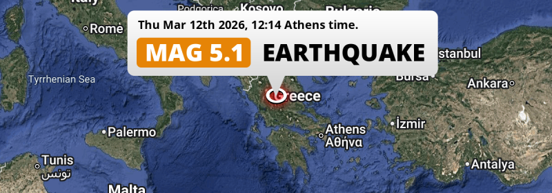
Under land 36 kilometer from Tríkala in Greece, a shallow and significant MAG-5.1 earthquake occurred around noon of Thursday March 12th, 2026. Shaking may have been felt by a total of 8 million people. Other nearby countries are Albania, North Macedonia and Bulgaria.
Felt the earthquake? Share this article: 


Earthquake Summary
The earthquake struck on land in Greece, 36 kilometer (22 mi) southwest of Tríkala in Thessaly. The center of this earthquake had a very shallow depth of 10 km. Shallow earthquakes usually have a larger impact than earthquakes deep in the earth.
| Date and Time: | Mar 12, 2026 12:14 (Athens Time) - Mar 12, 2026 10:14 Universal Time. |
|---|---|
| Location: | 36 km SW of Tríkala, Thessaly, Greece. Coordinates 39°15'49"N 21°35'53"E. |
| Map: | 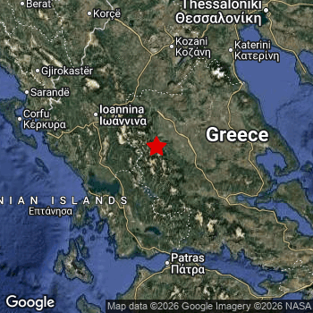 Map of area around epicenter. Click to open in Google Maps. |
| Magnitude: | MAG 5.1 Detected by 170 stations. Maximum Error Range ±0.044 . |
| Depth: | 10 km (6 mi) A very shallow depth. |
| Max. Intensity: | VII
Very Strong On the Modified Mercalli Scale. |
| Tsunami Risk: | Tsunami very unlikely While this was a shallow earthquake, it appears to have occurred under land with a magnitude not strong enough to cause tsunami's. Always stay cautious - More info here. |
Minimal impact predicted
Based on scientific estimates by the US Geographic Survey (USGS), the risk of high fatalities for this earthquake is classified at level GREEN (low). They expect an 65% likelyhood of between 0 and 1 fatalities, and a 96% chance that the number of fatalities falls no higher than 10.
The USGS classifies the economic impact of this earthquake at level GREEN (low). They expect an 99% likelyhood of between 0 and 1 million US Dollars in economic damage and impact.
Roughly 8 million people exposed to shaking
An estimated 8 million have been exposed to shaking (An MMI or Modified Mercalli Intensity level II or higher) as a result of this earthquake according scientific estimates published by the USGS.
Very strong shaking and likely moderate damage may have been experienced by an estimated 40 people. At VII, it is the highest MMI level this earthquake has caused. Intensity level II was experienced by the majority of people (around 6.6 million). In their region, very weak shaking and no damage can be expected.
People in 3 countries have been exposed to shaking. In Greece , around 7.4 million people, with impact levels up to VII (very strong shaking, likely moderate damage). In Albania , around 0.9 million people. People were exposed to shaking in North Macedonia as well.
| People | MMI Level | Shaking | Damage |
|---|---|---|---|
| 898,400 | I |
Not noticable | None |
| 6,623,000 | II |
Very weak | None |
| 1,570,000 | III |
Weak | Probably none |
| 191,300 | IV |
Light | Likely none |
| 4,780 | V |
Moderate | Very light |
| 2,000 | VI |
Strong | Light |
| 40 | VII |
Very Strong | Moderate |
| 0 | VIII |
Severe | Moderate to heavy |
| 0 | IX |
Violent | Heavy |
| 0 | X |
Extreme | Very heavy |
Nearby towns and cities
4 countries can be found within 300km of the epicenter of this earthquake: Greece , Albania , North Macedonia and Bulgaria .
Located 30 kilometer (19 mi) west of the epicenter of this earthquake, Kardítsa (Thessaly, Greece) is the nearest significant population center. Kardítsa experienced an earthquake intensity (MMI Scale) of roughly IV. That level implies light shaking and likely no damage.
Major cities near this earthquake: Athens is located 233 km to the south-east and experienced an intensity of II (very weak shaking, no damage). Thessaloníki is located 191 km to the north-east and experienced an intensity of II (very weak shaking, no damage). Lárisa is located 82 km to the north-east and experienced an intensity of III (weak shaking, probably no damage).
The table below provides an overview of all places in proximity of today's earthquake. Where available, the estimated intensity on the Modified Mercalli Intensity Scale in each place is included. Places where this information is omitted likely experienced little impact.
Overview of nearby places
| Distance | Place | Intensity (MMI) |
|---|---|---|
| 30 km (19 mi) E from epicenter |
Kardítsa Thessaly, Greece. |
IV
Light |
| 36 km (22 mi) NE from epicenter |
Tríkala Thessaly, Greece. |
IV
Light |
| 54 km (34 mi) W from epicenter |
Árta Epirus, Greece. |
III
Weak |
| 73 km (45 mi) S from epicenter |
Agrínio West Greece, Greece. |
III
Weak |
| 78 km (48 mi) NW from epicenter |
Ioánnina Epirus, Greece. |
III
Weak |
| 81 km (50 mi) SW from epicenter |
Préveza Epirus, Greece. |
III
Weak |
| 82 km (51 mi) NE from epicenter |
Lárisa Thessaly, Greece. |
III
Weak |
| 83 km (52 mi) SE from epicenter |
Lamía Central Greece, Greece. |
III
Weak |
| 114 km (71 mi) S from epicenter |
Pátra West Greece, Greece. |
III
Weak |
| 115 km (71 mi) E from epicenter |
Néa Ionía Thessaly, Greece. |
III
Weak |
| 116 km (72 mi) N from epicenter |
Kozáni West Macedonia, Greece. |
III
Weak |
| 116 km (72 mi) E from epicenter |
Volos Thessaly, Greece. |
III
Weak |
| 120 km (75 mi) S from epicenter |
Aígio West Greece, Greece. |
II
Weak |
| 136 km (85 mi) NE from epicenter |
Kateríni Central Macedonia, Greece. |
III
Weak |
| 139 km (86 mi) N from epicenter |
Ptolemaḯda West Macedonia, Greece. |
III
Weak |
| 144 km (89 mi) SE from epicenter |
Livadeiá Central Greece, Greece. |
II
Weak |
| 149 km (93 mi) N from epicenter |
Véroia Central Macedonia, Greece. |
II
Weak |
| 150 km (93 mi) W from epicenter |
Corfu Ionian Islands, Greece. |
III
Weak |
| 153 km (95 mi) NW from epicenter |
Sarandë Vlorë, Albania. |
II
Weak |
| 154 km (96 mi) NW from epicenter |
Gjirokastër Gjirokastër, Albania. |
II
Weak |
| 157 km (98 mi) N from epicenter |
Náousa Central Macedonia, Greece. |
II
Weak |
| 164 km (102 mi) S from epicenter |
Amaliáda West Greece, Greece. |
II
Weak |
| 166 km (103 mi) NW from epicenter |
Korçë Korçë, Albania. |
II
Weak |
| 170 km (106 mi) N from epicenter |
Flórina West Macedonia, Greece. |
II
Weak |
| 177 km (110 mi) S from epicenter |
Pýrgos West Greece, Greece. |
II
Weak |
| 182 km (113 mi) SE from epicenter |
Thívai Central Greece, Greece. |
II
Weak |
| 183 km (114 mi) N from epicenter |
Giannitsá Central Macedonia, Greece. |
II
Weak |
| 187 km (116 mi) NE from epicenter |
Kalamariá Central Macedonia, Greece. |
II
Weak |
| 188 km (117 mi) SE from epicenter |
Kórinthos Peloponnese, Greece. |
II
Weak |
| 190 km (118 mi) NE from epicenter |
Pylaía Central Macedonia, Greece. |
II
Weak |
| 191 km (119 mi) NE from epicenter |
Thessaloníki Central Macedonia, Greece. |
II
Weak |
| 192 km (119 mi) NE from epicenter |
Neapoli Central Macedonia, Greece. |
II
Weak |
| 192 km (119 mi) NE from epicenter |
Sykiés Central Macedonia, Greece. |
II
Weak |
| 194 km (121 mi) NE from epicenter |
Políchni Central Macedonia, Greece. |
II
Weak |
| 195 km (121 mi) SE from epicenter |
Chalkída Central Greece, Greece. |
II
Weak |
| 198 km (123 mi) N from epicenter |
Bitola Bitola, North Macedonia. |
II
Weak |
| 199 km (124 mi) NW from epicenter |
Pogradec Korçë, Albania. |
II
Weak |
| 209 km (130 mi) N from epicenter |
Resen Resen, North Macedonia. |
|
| 213 km (132 mi) NW from epicenter |
Berat Berat, Albania. |
II
Weak |
| 217 km (135 mi) N from epicenter |
Ohrid Ohrid, North Macedonia. |
|
| 222 km (138 mi) N from epicenter |
Gevgelija Gevgelija, North Macedonia. |
|
| 225 km (140 mi) NW from epicenter |
Vlorë Vlorë, Albania. |
II
Weak |
| 227 km (141 mi) SE from epicenter |
Acharnés Attica, Greece. |
II
Weak |
| 227 km (141 mi) N from epicenter |
Struga Struga, North Macedonia. |
|
| 228 km (142 mi) SE from epicenter |
Ílion Attica, Greece. |
II
Weak |
| 228 km (142 mi) SE from epicenter |
Keratsíni Attica, Greece. |
II
Weak |
| 229 km (142 mi) SE from epicenter |
Níkaia Attica, Greece. |
II
Weak |
| 229 km (142 mi) SE from epicenter |
Peristéri Attica, Greece. |
II
Weak |
| 231 km (144 mi) NW from epicenter |
Patos Fier, Albania. |
II
Weak |
| 231 km (144 mi) SE from epicenter |
Piraeus Attica, Greece. |
II
Weak |
| 231 km (144 mi) N from epicenter |
Prilep Prilep, North Macedonia. |
|
| 233 km (145 mi) SE from epicenter |
Athens Attica, Greece. |
II
Weak |
| 234 km (145 mi) SE from epicenter |
Kallithéa Attica, Greece. |
II
Weak |
| 243 km (151 mi) NW from epicenter |
Elbasan Elbasan, Albania. |
|
| 244 km (152 mi) N from epicenter |
Kavadarci Kavadarci, North Macedonia. |
|
| 244 km (152 mi) SE from epicenter |
Glyfáda Attica, Greece. |
II
Weak |
| 250 km (155 mi) N from epicenter |
Negotino Negotino, North Macedonia. |
|
| 256 km (159 mi) N from epicenter |
Kičevo Kichevo, North Macedonia. |
|
| 257 km (160 mi) N from epicenter |
Strumica Strumica, North Macedonia. |
|
| 262 km (163 mi) N from epicenter |
Centar Župa Centar Zhupa, North Macedonia. |
|
| 267 km (166 mi) N from epicenter |
Debar Debar, North Macedonia. |
|
| 273 km (170 mi) N from epicenter |
Veles Veles, North Macedonia. |
|
| 274 km (170 mi) NE from epicenter |
Petrich Blagoevgrad, Bulgaria. |
|
| 274 km (170 mi) N from epicenter |
Radovis Radovish, North Macedonia. |
|
| 275 km (171 mi) NW from epicenter |
Tirana Tirana, Albania. |
|
| 281 km (175 mi) N from epicenter |
Shtip Shtip, North Macedonia. |
|
| 288 km (179 mi) N from epicenter |
Gostivar Gostivar, North Macedonia. |
|
| 292 km (181 mi) NW from epicenter |
Durrës Durrës, Albania. |
|
| 294 km (183 mi) NW from epicenter |
Burrel Dibër, Albania. |
|
| 296 km (184 mi) N from epicenter |
Studeničani Studeničani, North Macedonia. |
|
| 297 km (185 mi) N from epicenter |
Negotino Vrapchishte, North Macedonia. |
|
| 299 km (186 mi) N from epicenter |
Kisela Voda Grad Skopje, North Macedonia. |
Earthquake Intensity Map
The maximum intensity (MMI Scale) caused by this earthquake is VII. The map below shows in which areas this earthquake was the most and least impactful. It is based on data from the US Geographic Survey.

Shaking reported by 4 people
People that feel an earthquake may report their experience to the US Geographic Survey. Currently, 4 people have reported shaking in 4 places, all within Greece.We keep updating this article as more ground reports become available. You may report that you felt this earthquake here.
Places with most reports:
- Kardítsa, Kardítsa, Greece: 1 person.
- Agrínion, Aitolía kai Akarnanía, Greece: 1 person.
- Lárisa, Lárisa, Greece: 1 person.
- Pátrai, Ahaia, Greece: 1 person.
9 Aftershocks detected
Since this main shock, 9 smaller aftershocks were detected. A 4 magnitude earthquake hit 8 hrs later 4 km (2.5 mi) west of this earthquake.
This main shock was prefaced by 11 smaller foreshocks. A 3.5 magnitude earthquake hit 23 hrs earlier nearby.
Overview of foreshocks and aftershocks
| Classification | Magnitude | When | Where |
|---|---|---|---|
| Foreshock | M 2.5 |
3 days earlier Mar 9, 2026 19:00 (Athens Time) | 92 km (57 mi) NW from Main Shock. |
| Foreshock | M 3.1 |
3 days earlier Mar 9, 2026 20:31 (Athens Time) | 90 km (56 mi) NW from Main Shock. |
| Foreshock | M 2.8 |
2 days earlier Mar 10, 2026 14:52 (Athens Time) | 92 km (57 mi) NW from Main Shock. |
| Foreshock | M 2.6 |
2 days earlier Mar 10, 2026 15:29 (Athens Time) | 89 km (55 mi) W from Main Shock. |
| Foreshock | M 2.7 |
2 days earlier Mar 10, 2026 18:22 (Athens Time) | 91 km (56 mi) NW from Main Shock. |
| Foreshock | M 2.9 |
1 day earlier Mar 11, 2026 01:20 (Athens Time) | 90 km (56 mi) NW from Main Shock. |
| Foreshock | M 2.8 |
1 day earlier Mar 11, 2026 06:18 (Athens Time) | 94 km (58 mi) NW from Main Shock. |
| Foreshock | M 3.2 |
1 day earlier Mar 11, 2026 08:12 (Athens Time) | 88 km (55 mi) NW from Main Shock. |
| Foreshock | M 3.5 |
23 hrs earlier Mar 11, 2026 13:03 (Athens Time) | 94 km (59 mi) NW from Main Shock. |
| Foreshock | M 2.7 |
20 hrs earlier Mar 11, 2026 16:08 (Athens Time) | 96 km (60 mi) NW from Main Shock. |
| Foreshock | M 2.7 |
17 hrs earlier Mar 11, 2026 18:46 (Athens Time) | 96 km (59 mi) NW from Main Shock. |
| Main Shock This Earthquake |
M 5.1 |
Mar 12, 2026 12:14 (Athens Time) | - |
| Aftershock | M 4.0 |
8 hrs later Mar 12, 2026 20:36 (Athens Time) | 4 km (2.5 mi) W from Main Shock. |
| Aftershock | M 3.5 |
16 hrs later Mar 13, 2026 04:25 (Athens Time) | 91 km (56 mi) NW from Main Shock. |
| Aftershock | M 2.5 |
17 hrs later Mar 13, 2026 05:27 (Athens Time) | 74 km (46 mi) S from Main Shock. |
| Aftershock | M 2.8 |
1 day later Mar 13, 2026 12:38 (Athens Time) | 89 km (55 mi) NW from Main Shock. |
| Aftershock | M 2.7 |
2 days later Mar 14, 2026 05:53 (Athens Time) | 93 km (58 mi) NW from Main Shock. |
| Aftershock | M 3.0 |
2 days later Mar 14, 2026 12:59 (Athens Time) | 91 km (57 mi) NW from Main Shock. |
| Aftershock | M 2.5 |
3 days later Mar 15, 2026 03:50 (Athens Time) | 57 km (36 mi) NW from Main Shock. |
| Aftershock | M 3.0 |
3 days later Mar 15, 2026 07:41 (Athens Time) | 90 km (56 mi) NW from Main Shock. |
| Aftershock | M 3.2 |
3 days later Mar 15, 2026 08:18 (Athens Time) | 94 km (58 mi) NW from Main Shock. |
More earthquakes coming?
Aftershocks are usually at least 1 order of magnitude less strong than main shocks. The more time passes, the smaller the chance and likely strength of any potential aftershocks.
It's always adviced to be cautious of the risk of a larger shock following any significant earthquake, however this risk is fairly small. There is a roughly 94 percent change that no larger main shock will follow in the days following this earthquake.
Read: How to Stay Safe during an Earthquake (cdc.gov).Earthquakes like this happen often in the region
Earthquakes of this strength are very common in the region. This is the strongest earthquake to hit since March 8th, 2026, when a 5.5 magnitude earthquake hit 92 km (57 mi) further northwest. An even stronger magnitude 6.8 earthquake struck on October 25th, 2018.
In total, 33 earthquakes with a magnitude of 5.1 or higher have been registered within 300km (186 mi) of this epicenter in the past 10 years. This comes down to an average of once every 4 months.
Tsunami very unlikely
While MAG-6.5+ earthquakes may cause tsunami's, it appears that the epicenter of this earthquake hit under land. In addition, the reported depth is deeper than 100km, making the risk of a tsunami even less likely. However always stay cautious and monitor advice from local authorities.
Tsunami Risk Factors
| Factor | Under Sea? | MAG-6.5 or stronger? | Shallow depth? |
|---|---|---|---|
| Explanation | Almost all tsunami's are caused by earthquakes with their epicenter under sea or very near the sea. However stay cautious in coastal areas as earthquakes on land may cause landslides into sea, potentially still causing a local tsunami. | Under MAG 6.5: Very unlikely to cause a tsunami. MAG 6.5 to 7.5: Destructive tsunami's do occur, but are uncommon. Likely to observe small sea level changes. MAG 7.6+: Earthquakes with these magnitudes might produce destructive tsunami's. |
Most destructive tsunami's are caused by shallow earthquakes with a depth between 0 and 100km under the surface of the earth. Deeper tsunami's are unlikely to displace to ocean floor. |
| This Earthquake | Not this earthquake. This earthquake appears to have struck on land far from any coast. |
Not this earthquake. This earthquake had a magnitude of 5.1. Earthquakes of this strength are unlikely to trigger a tsunami. |
This earthquake occurred at a depth of of 10 km (6 mi). Earthquakes this shallow could trigger a tsunami. |
Sources
Last updated 01/04/26 12:18 (). This article is automatically generated based on available data. We keep checking multiple sources for additional information. This article gets updated as new details on this earthquake become available.
- US Geographic Society (USGS): Earthquake us6000sft6
- European-Mediterranean Seismological Centre (EMSC): Earthquake 20260312_0000138
- Geonames.org: World Cities Database
- Google Maps: Static API
- Earthquakelist.org: Historic Earthquakes Database
Share this article:
