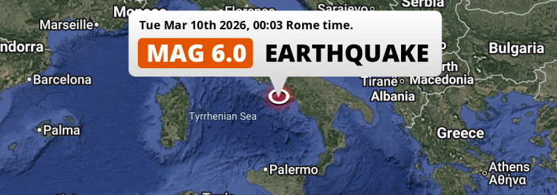
A strong MAG-6.0 earthquake struck in the Tirreno Sea 39 kilometer from Naples, Italy just after midnight of Tuesday March 10th, 2026. The earthquake struck near a very densely populated region. Roughly 11 million people may have felt this earthquake.
Felt the earthquake? Share this article: 


Earthquake Summary
This earthquake hit under water in the Tirreno Sea, 29 kilometers (18 mi) off the coast of Italy, 39 kilometer southwest of Naples in Campania. The center of this earthquake had a deep depth of 378 km.
| Date and Time: | Mar 10, 2026 00:03 (Rome Time) - Mar 9, 2026 23:03 Universal Time. |
|---|---|
| Location: | 39 km SW of Naples, Campania, Italy. Coordinates 40°34'37"N 13°59'19"E. |
| Map: | 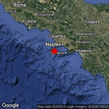 Map of area around epicenter. Click to open in Google Maps. |
| Magnitude: | MAG 6.0 Detected by 47 stations. Maximum Error Range ±0.045 . |
| Depth: | 378 km (235 mi) A deep depth. |
| Max. Intensity: | IV
Light On the Modified Mercalli Scale. |
| Tsunami Risk: | Tsunami very unlikely Earthquakes under MAG-6.5 at depths deeper than 100km are very unlikely to cause tsunami's. Always stay cautious - More info here. |
Minimal impact predicted
Based on scientific estimates by the US Geographic Survey (USGS), the risk of high fatalities for this earthquake is classified at level GREEN (low). They expect an 90% likelyhood of between 0 and 1 fatalities.
The USGS classifies the economic impact of this earthquake at level GREEN (low). They expect an 90% likelyhood of between 0 and 1 million US Dollars in economic damage and impact.
Roughly 11 million people exposed to shaking
The USGS has published a report estimating the number of people exposed to this earthquake. Acoording to their analysis, roughly 11 million have been exposed to shaking at an MMI level of II or higher.
An estimated 1,837,000 people were exposed to level III. At this level, weak shaking and probably no damage can be expected. Intensity level II was experienced by the majority of people (around 9 million). In their region, very weak shaking and no damage can be expected. All exposure to shaking was within the borders of Italy .
| People | MMI Level | Shaking | Damage |
|---|---|---|---|
| 3,301,000 | I |
Not noticable | None |
| 9,362,000 | II |
Very weak | None |
| 1,837,000 | III |
Weak | Probably none |
| 0 | IV |
Light | Likely none |
| 0 | V |
Moderate | Very light |
| 0 | VI |
Strong | Light |
| 0 | VII |
Very Strong | Moderate |
| 0 | VIII |
Severe | Moderate to heavy |
| 0 | IX |
Violent | Heavy |
| 0 | X |
Extreme | Very heavy |
Nearby towns and cities
This earthquake may have been felt in Italy . Ischia Porto in Campania, Italy is the nearest significant place from the epicenter. The earthquake occurred 18 kilometer (11 mi) south of Ischia Porto. The intensity of shaking and damage in Ischia Porto is estimated to be around level I on the Modified Mercalli Intensity scale (not noticeable, no damage).
Multiple large cities are in proximity of today's earthquake. Naples is located 39 km to the north-east and experienced an intensity of I (not noticeable, no damage). Rome is located 191 km to the northwest and experienced an intensity of II (very weak shaking, no damage). Palermo is located 278 km to the south (intensity unknown, possibly low).
An overview of nearby towns and cities is available in the overview below. If places don't have intensity data available, it likely means the experienced impact in those places was fairly small.
Overview of nearby places
| Distance | Place | Intensity (MMI) |
|---|---|---|
| 18 km (11 mi) N from epicenter |
Ischia Campania, Italy. |
I
Not felt |
| 18 km (11 mi) N from epicenter |
Ischia Porto Campania, Italy. |
I
Not felt |
| 21 km (13 mi) NW from epicenter |
Forio Campania, Italy. |
I
Not felt |
| 25 km (16 mi) N from epicenter |
Bacoli Campania, Italy. |
I
Not felt |
| 30 km (19 mi) NE from epicenter |
Bagnoli Campania, Italy. |
I
Not felt |
| 31 km (19 mi) N from epicenter |
Pozzuoli Campania, Italy. |
I
Not felt |
| 32 km (20 mi) NE from epicenter |
Posillipo Campania, Italy. |
I
Not felt |
| 33 km (21 mi) N from epicenter |
Monterusciello Campania, Italy. |
I
Not felt |
| 34 km (21 mi) NE from epicenter |
Soccavo Campania, Italy. |
I
Not felt |
| 34 km (21 mi) NE from epicenter |
Fuorigrotta Campania, Italy. |
I
Not felt |
| 35 km (22 mi) NE from epicenter |
Chiaia Campania, Italy. |
I
Not felt |
| 35 km (22 mi) NE from epicenter |
Pianura Campania, Italy. |
I
Not felt |
| 36 km (22 mi) NE from epicenter |
Vomero Campania, Italy. |
I
Not felt |
| 36 km (22 mi) N from epicenter |
Quarto Campania, Italy. |
I
Not felt |
| 37 km (23 mi) NE from epicenter |
Arenella Campania, Italy. |
I
Not felt |
| 37 km (23 mi) NE from epicenter |
Montecalvario Campania, Italy. |
I
Not felt |
| 38 km (24 mi) NE from epicenter |
Avvocata Campania, Italy. |
I
Not felt |
| 39 km (24 mi) NE from epicenter |
Stella Campania, Italy. |
I
Not felt |
| 39 km (24 mi) NE from epicenter |
Chiaiano Campania, Italy. |
I
Not felt |
| 39 km (24 mi) NE from epicenter |
Naples Campania, Italy. |
I
Not felt |
| 39 km (24 mi) NE from epicenter |
San Lorenzo Campania, Italy. |
I
Not felt |
| 39 km (24 mi) NE from epicenter |
Marano di Napoli Campania, Italy. |
I
Not felt |
| 39 km (24 mi) NE from epicenter |
San Giovanni a Teduccio Campania, Italy. |
I
Not felt |
| 40 km (25 mi) NE from epicenter |
Portici Campania, Italy. |
I
Not felt |
| 40 km (25 mi) N from epicenter |
Qualiano Campania, Italy. |
I
Not felt |
| 40 km (25 mi) NE from epicenter |
San Carlo All'Arena Campania, Italy. |
I
Not felt |
| 40 km (25 mi) NE from epicenter |
Torre del Greco Campania, Italy. |
I
Not felt |
| 40 km (25 mi) NE from epicenter |
Ercolano Campania, Italy. |
I
Not felt |
| 41 km (25 mi) NE from epicenter |
Piscinola Campania, Italy. |
I
Not felt |
| 41 km (25 mi) NE from epicenter |
Mugnano di Napoli Campania, Italy. |
I
Not felt |
| 41 km (25 mi) NE from epicenter |
Barra Campania, Italy. |
I
Not felt |
| 41 km (25 mi) NE from epicenter |
San Giorgio a Cremano Campania, Italy. |
I
Not felt |
| 42 km (26 mi) NE from epicenter |
Scampia Campania, Italy. |
I
Not felt |
| 42 km (26 mi) NE from epicenter |
Villaricca Campania, Italy. |
I
Not felt |
| 42 km (26 mi) NE from epicenter |
Ponticelli Campania, Italy. |
I
Not felt |
| 43 km (27 mi) NE from epicenter |
Secondigliano Campania, Italy. |
I
Not felt |
| 43 km (27 mi) NE from epicenter |
Giugliano in Campania Campania, Italy. |
II
Weak |
| 43 km (27 mi) NE from epicenter |
Melito di Napoli Campania, Italy. |
I
Not felt |
| 44 km (27 mi) E from epicenter |
Castellammare di Stabia Campania, Italy. |
I
Not felt |
| 44 km (27 mi) NE from epicenter |
Torre Annunziata Campania, Italy. |
I
Not felt |
| 44 km (27 mi) NE from epicenter |
Arzano Campania, Italy. |
I
Not felt |
| 45 km (28 mi) NE from epicenter |
Casoria Campania, Italy. |
I
Not felt |
| 46 km (29 mi) NE from epicenter |
Sant'Antimo Campania, Italy. |
II
Weak |
| 47 km (29 mi) NE from epicenter |
Afragola Campania, Italy. |
II
Weak |
| 48 km (30 mi) N from epicenter |
Aversa Campania, Italy. |
II
Weak |
| 48 km (30 mi) NE from epicenter |
Casalnuovo di Napoli Campania, Italy. |
I
Not felt |
| 50 km (31 mi) NE from epicenter |
Pomigliano d'Arco Campania, Italy. |
I
Not felt |
| 51 km (32 mi) NE from epicenter |
Scafati Campania, Italy. |
II
Weak |
| 52 km (32 mi) NE from epicenter |
Acerra Campania, Italy. |
II
Weak |
| 62 km (39 mi) NE from epicenter |
Caserta Campania, Italy. |
II
Weak |
| 69 km (43 mi) E from epicenter |
Salerno Campania, Italy. |
II
Weak |
| 123 km (76 mi) NE from epicenter |
Campobasso Molise, Italy. |
II
Weak |
| 154 km (96 mi) E from epicenter |
Potenza Basilicate, Italy. |
I
Not felt |
| 164 km (102 mi) NE from epicenter |
Foggia Apulia, Italy. |
II
Weak |
| 168 km (104 mi) N from epicenter |
Avezzano Abruzzo, Italy. |
II
Weak |
| 191 km (119 mi) NW from epicenter |
Rome Lazio, Italy. |
II
Weak |
| 240 km (149 mi) SE from epicenter |
Cosenza Calabria, Italy. |
II
Weak |
| 248 km (154 mi) NW from epicenter |
Terni Umbria, Italy. |
|
| 265 km (165 mi) N from epicenter |
San Benedetto del Tronto The Marches, Italy. |
|
| 278 km (173 mi) S from epicenter |
Palermo Sicily, Italy. |
|
| 365 km (227 mi) NW from epicenter |
Arezzo Tuscany, Italy. |
|
| 380 km (236 mi) W from epicenter |
Olbia Sardinia, Italy. |
|
| 384 km (239 mi) NE from epicenter |
Split Split-Dalmatia, Croatia. |
|
| 385 km (239 mi) NE from epicenter |
Šibenik Šibensko-Kniniska, Croatia. |
|
| 395 km (245 mi) N from epicenter |
San Marino San Marino, San Marino. |
|
| 396 km (246 mi) N from epicenter |
Riccione Emilia-Romagna, Italy. |
Earthquake Intensity Map
The graph below overlays a map of the region around the epicenter with earthquake intensity data provided by the US Geographic Survey. The highest intensity level detected for this earthquake is III.

Shaking reported by 13 people in 3 countries
People that feel an earthquake may report their experience to the US Geographic Survey. Currently, 13 people have reported shaking in 11 places in 3 countries (Italy, Tunisia, Serbia and Montenegro).We keep updating this article as more ground reports become available. You may report that you felt this earthquake here.
Places with most reports:
- Podgorica, Montenegro, Serbia and Montenegro: 2 people.
- Naples, Campania, Italy: 2 people.
- Lecce, Apulien, Italy: 1 person.
- Cagliari, Sardinien, Italy: 1 person.
- Maqrīn, Bin ʿArūs, Tunisia: 1 person.
- Milan, Lombardei, Italy: 1 person.
- LʿAquila, Abruzzen, Italy: 1 person.
- Rome, Lazio, Italy: 1 person.
- Monreale, Sizilien, Italy: 1 person.
- Grosseto, Toscana, Italy: 1 person.
Aftershocks detected
Before this earthquake struck, 1 smaller foreshock occurred. Roughly 2 days before this earthquake, a foreshock measuring MAG-2.8 was detected nearby this earthquake.
Overview of foreshocks and aftershocks
| Classification | Magnitude | When | Where |
|---|---|---|---|
| Foreshock | M 2.8 |
2 days earlier Mar 8, 2026 07:28 (Rome Time) | 70 km (43 mi) NE from Main Shock. |
| Main Shock This Earthquake |
M 6.0 |
Mar 10, 2026 00:03 (Rome Time) | - |
More earthquakes coming?
Aftershocks are usually at least 1 order of magnitude less strong than main shocks. The more time passes, the smaller the chance and likely strength of any potential aftershocks.
In only six percent of cases, significant earthquakes are followed by a larger main shock, making the current earthquake a foreshock. While the chance of this happening is not so large, it is adviced to maintain cautiousness in the hours and days following a major earthquake.
Read: How to Stay Safe during an Earthquake (cdc.gov).This is the strongest earthquake in 9 years
Earthquakes of this strength occur quite regularly in the region. This is the strongest earthquake to hit since October 30th, 2016, when a 6.6 magnitude earthquake hit 265 km (164 mi) further north. That was also the heaviest earthquake to hit the region in the past 10 years.
In total, 3 earthquakes with a magnitude of 6 or higher have been registered within 300km (186 mi) of this epicenter in the past 10 years. This comes down to an average of once every 3 years.
Tsunami very unlikely
For a serious tsunami to occur, earthquakes usually need to have a magnitude of at least 6.5 and occur at a shallow depth of maximum 100km. Neither are the case with this earthquake. However always stay cautious and monitor advice from local authorities.
Tsunami Risk Factors
| Factor | Under Sea? | MAG-6.5 or stronger? | Shallow depth? |
|---|---|---|---|
| Explanation | Almost all tsunami's are caused by earthquakes with their epicenter under sea or very near the sea. However stay cautious in coastal areas as earthquakes on land may cause landslides into sea, potentially still causing a local tsunami. | Under MAG 6.5: Very unlikely to cause a tsunami. MAG 6.5 to 7.5: Destructive tsunami's do occur, but are uncommon. Likely to observe small sea level changes. MAG 7.6+: Earthquakes with these magnitudes might produce destructive tsunami's. |
Most destructive tsunami's are caused by shallow earthquakes with a depth between 0 and 100km under the surface of the earth. Deeper tsunami's are unlikely to displace to ocean floor. |
| This Earthquake | This earthquake appears to have struck under the sea. | Not this earthquake. This earthquake had a magnitude of 6. Earthquakes of this strength are unlikely to trigger a tsunami. |
Not this earthquake. This earthquake occurred at a depth of 378 km (235 mi). Earthquakes this deep in the earth are unlikely to trigger a tsunami. |
Sources
Last updated 01/04/26 01:08 (). This article contains currently available information about the earthquake and is automatically composed. We continue to update this article up to a few days after the earthquake occurred.
- US Geographic Society (USGS): Earthquake us7000s39n
- European-Mediterranean Seismological Centre (EMSC): Earthquake 20260309_0000447
- Geonames.org: World Cities Database
- Google Maps: Static API
- Earthquakelist.org: Historic Earthquakes Database
Share this article:
