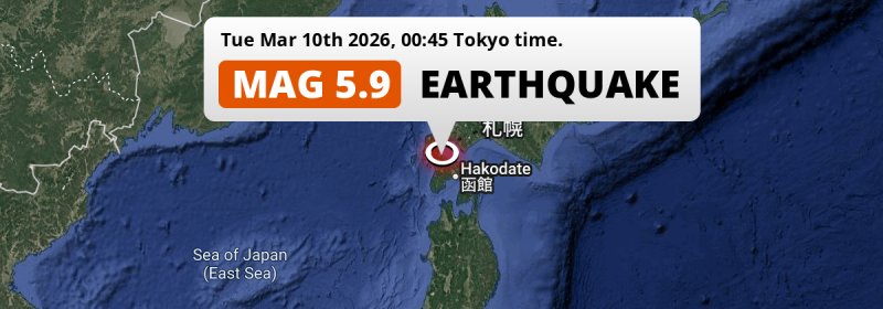
In the night of Tuesday March 10th, 2026, a significant MAG-5.9 earthquake hit under land 49 kilometer from Hakodate in Japan. Roughly 5.4 million people may have felt this earthquake.
Felt the earthquake? Share this article: 


Earthquake Summary
The earthquake struck on land in Japan, 49 kilometer (30 mi) northwest of Hakodate in Hokkaido. The center of this earthquake had an intermediate depth of 144 km.
| Date and Time: | Mar 10, 2026 00:45 (Tokyo Time) - Mar 9, 2026 15:45 Universal Time. |
|---|---|
| Location: | 49 km NW of Hakodate, Hokkaido, Japan. Coordinates 42°5'12"N 140°18'33"E. |
| Map: | 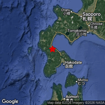 Map of area around epicenter. Click to open in Google Maps. |
| Magnitude: | MAG 5.9 Detected by 65 stations. Maximum Error Range ±0.038 . |
| Depth: | 144 km (89 mi) An intermediate depth. |
| Max. Intensity: | V
Moderate On the Modified Mercalli Scale. |
| Tsunami Risk: | Tsunami very unlikely Tsunami's are usually caused by MAG-6.5+ earthquakes, less than 100km shallow, and with an epicenter under sea. Neither of this seems to be the case. Always stay cautious - More info here. |
Minimal impact predicted
Based on scientific estimates by the US Geographic Survey (USGS), the risk of high fatalities for this earthquake is classified at level GREEN (low). They expect an 90% likelyhood of between 0 and 1 fatalities.
The USGS classifies the economic impact of this earthquake at level GREEN (low). They expect an 90% likelyhood of between 0 and 1 million US Dollars in economic damage and impact.
Roughly 5.4 million people exposed to shaking
The USGS has published a report estimating the number of people exposed to this earthquake. Acoording to their analysis, roughly 5.4 million have been exposed to shaking at an MMI level of II or higher.
An estimated 2,605,000 people were exposed to level IV. At this level, light shaking and likely no damage can be expected. Intensity level III was experienced by the majority of people (around 2.8 million). In their region, weak shaking and probably no damage can be expected. All exposure to shaking was within the borders of Japan .
| People | MMI Level | Shaking | Damage |
|---|---|---|---|
| 0 | I |
Not noticable | None |
| 1,260 | II |
Very weak | None |
| 2,756,000 | III |
Weak | Probably none |
| 2,605,000 | IV |
Light | Likely none |
| 0 | V |
Moderate | Very light |
| 0 | VI |
Strong | Light |
| 0 | VII |
Very Strong | Moderate |
| 0 | VIII |
Severe | Moderate to heavy |
| 0 | IX |
Violent | Heavy |
| 0 | X |
Extreme | Very heavy |
Nearby towns and cities
This earthquake may have been felt in Japan . Honchō in Hokkaido, Japan is the nearest significant place from the epicenter. The earthquake occurred 38 kilometer (24 mi) northwest of Honchō. The intensity of shaking and damage in Honchō is estimated to be around level IV on the Modified Mercalli Intensity scale (light shaking, likely no damage).
Multiple major population centers exist within 300km of the earthquake that struck today. Sapporo is located 138 km to the north-east and experienced an intensity of IV (light shaking, likely no damage). Hakodate is located 49 km to the south-east and experienced an intensity of IV (light shaking, likely no damage). Aomori is located 146 km to the south and experienced an intensity of IV (light shaking, likely no damage).
The table below provides an overview of all places in proximity of today's earthquake. Where available, the estimated intensity on the Modified Mercalli Intensity Scale in each place is included. Places where this information is omitted likely experienced little impact.
Overview of nearby places
| Distance | Place | Intensity (MMI) |
|---|---|---|
| 38 km (24 mi) SE from epicenter |
Honchō Hokkaido, Japan. |
IV
Light |
| 41 km (25 mi) SE from epicenter |
Kamiiso Hokkaido, Japan. |
IV
Light |
| 49 km (30 mi) SE from epicenter |
Hakodate Hokkaido, Japan. |
IV
Light |
| 62 km (39 mi) NE from epicenter |
Muroran Hokkaido, Japan. |
IV
Light |
| 63 km (39 mi) NE from epicenter |
Date Hokkaido, Japan. |
IV
Light |
| 100 km (62 mi) NE from epicenter |
Shiraoi Hokkaido, Japan. |
IV
Light |
| 116 km (72 mi) SE from epicenter |
Mutsu Aomori, Japan. |
IV
Light |
| 123 km (76 mi) NE from epicenter |
Tomakomai Hokkaido, Japan. |
IV
Light |
| 130 km (81 mi) N from epicenter |
Yoichi Hokkaido, Japan. |
IV
Light |
| 135 km (84 mi) NE from epicenter |
Otaru Hokkaido, Japan. |
IV
Light |
| 137 km (85 mi) NE from epicenter |
Chitose Hokkaido, Japan. |
IV
Light |
| 138 km (86 mi) NE from epicenter |
Sapporo Hokkaido, Japan. |
IV
Light |
| 141 km (88 mi) S from epicenter |
Shimokizukuri Aomori, Japan. |
IV
Light |
| 143 km (89 mi) S from epicenter |
Goshogawara Aomori, Japan. |
IV
Light |
| 143 km (89 mi) NE from epicenter |
Kitahiroshima Hokkaido, Japan. |
IV
Light |
| 146 km (91 mi) S from epicenter |
Aomori Aomori, Japan. |
IV
Light |
| 152 km (94 mi) NE from epicenter |
Ebetsu Hokkaido, Japan. |
IV
Light |
| 154 km (96 mi) NE from epicenter |
Ishikari Hokkaido, Japan. |
IV
Light |
| 155 km (96 mi) S from epicenter |
Namioka Aomori, Japan. |
III
Weak |
| 160 km (99 mi) NE from epicenter |
Tōbetsu Hokkaido, Japan. |
IV
Light |
| 162 km (101 mi) S from epicenter |
Kuroishi Aomori, Japan. |
III
Weak |
| 167 km (104 mi) S from epicenter |
Hirosaki Aomori, Japan. |
III
Weak |
| 171 km (106 mi) NE from epicenter |
Iwamizawa Hokkaido, Japan. |
IV
Light |
| 172 km (107 mi) E from epicenter |
Shizunai-furukawachō Hokkaido, Japan. |
III
Weak |
| 180 km (112 mi) SE from epicenter |
Misawa Aomori, Japan. |
III
Weak |
| 187 km (116 mi) NE from epicenter |
Bibai Hokkaido, Japan. |
III
Weak |
| 203 km (126 mi) NE from epicenter |
Sunagawa Hokkaido, Japan. |
III
Weak |
| 203 km (126 mi) SE from epicenter |
Hachinohe Aomori, Japan. |
III
Weak |
| 203 km (126 mi) S from epicenter |
Ōdate Akita, Japan. |
III
Weak |
| 207 km (129 mi) S from epicenter |
Takanosu Akita, Japan. |
|
| 209 km (130 mi) NE from epicenter |
Takikawa Hokkaido, Japan. |
III
Weak |
| 210 km (130 mi) S from epicenter |
Noshiro Akita, Japan. |
|
| 215 km (134 mi) S from epicenter |
Hanawa Akita, Japan. |
|
| 220 km (137 mi) NE from epicenter |
Shimo-furano Hokkaido, Japan. |
III
Weak |
| 220 km (137 mi) NE from epicenter |
Ashibetsu Hokkaido, Japan. |
III
Weak |
| 229 km (142 mi) NE from epicenter |
Fukagawa Hokkaido, Japan. |
III
Weak |
| 232 km (144 mi) NE from epicenter |
Rumoi Hokkaido, Japan. |
|
| 245 km (152 mi) S from epicenter |
Tennō Akita, Japan. |
|
| 251 km (156 mi) NE from epicenter |
Asahikawa Hokkaido, Japan. |
III
Weak |
| 255 km (158 mi) E from epicenter |
Obihiro Hokkaido, Japan. |
|
| 257 km (160 mi) NE from epicenter |
Otofuke Hokkaido, Japan. |
|
| 264 km (164 mi) S from epicenter |
Akita Akita, Japan. |
|
| 275 km (171 mi) S from epicenter |
Morioka Iwate, Japan. |
|
| 294 km (183 mi) S from epicenter |
Ōmagari Akita, Japan. |
|
| 304 km (189 mi) SE from epicenter |
Miyako Iwate, Japan. |
|
| 308 km (191 mi) S from epicenter |
Hanamaki Iwate, Japan. |
|
| 319 km (198 mi) S from epicenter |
Kitakami Iwate, Japan. |
|
| 347 km (216 mi) E from epicenter |
Kushiro Hokkaido, Japan. |
|
| 348 km (216 mi) NE from epicenter |
Kitami Hokkaido, Japan. |
|
| 355 km (221 mi) S from epicenter |
Sakata Yamagata, Japan. |
|
| 376 km (234 mi) S from epicenter |
Tsuruoka Yamagata, Japan. |
|
| 395 km (245 mi) S from epicenter |
Furukawa Miyagi, Japan. |
Earthquake Intensity Map
The graph below overlays a map of the region around the epicenter with earthquake intensity data provided by the US Geographic Survey. The highest intensity level detected for this earthquake is IV.

Risk of aftershocks?
We monitor for foreshocks or aftershocks that have a magnitude of 2.5+ and occur within 100km (62 mi) of the epicenter of this earthquake. So far no such earthquakes have been detected.
The risk of aftershocks decreases rapidly over time. Usually, aftershocks are at least one order of magnitude lower than a main shock.
In only six percent of cases, significant earthquakes are followed by a larger main shock, making the current earthquake a foreshock. While the chance of this happening is not so large, it is adviced to maintain cautiousness in the hours and days following a major earthquake.
Read: How to Stay Safe during an Earthquake (cdc.gov).Earthquakes like this happen often in the region
Earthquakes of this strength are very common in the region. This is the strongest earthquake to hit since December 12th, 2025, when a 6.7 magnitude earthquake hit 247 km (154 mi) further south-east. An even stronger magnitude 7.6 earthquake struck on December 8th, 2025.
In total, 14 earthquakes with a magnitude of 5.9 or higher have been registered within 300km (186 mi) of this epicenter in the past 10 years. This comes down to an average of once every 9 months.
Tsunami very unlikely
It is very unlikely that this eartquake will cause any tsunami's. The reported magnitude is lower than the MAG-6.5 strength required to cause any earthquakes. In addition, this earthquake was not very shallow and appears to have occurred under land. However always stay cautious and monitor advice from local authorities.
Tsunami Risk Factors
| Factor | Under Sea? | MAG-6.5 or stronger? | Shallow depth? |
|---|---|---|---|
| Explanation | Almost all tsunami's are caused by earthquakes with their epicenter under sea or very near the sea. However stay cautious in coastal areas as earthquakes on land may cause landslides into sea, potentially still causing a local tsunami. | Under MAG 6.5: Very unlikely to cause a tsunami. MAG 6.5 to 7.5: Destructive tsunami's do occur, but are uncommon. Likely to observe small sea level changes. MAG 7.6+: Earthquakes with these magnitudes might produce destructive tsunami's. |
Most destructive tsunami's are caused by shallow earthquakes with a depth between 0 and 100km under the surface of the earth. Deeper tsunami's are unlikely to displace to ocean floor. |
| This Earthquake | This earthquake appears to have struck on land near a coastal area (15 km from the sea). | Not this earthquake. This earthquake had a magnitude of 5.9. Earthquakes of this strength are unlikely to trigger a tsunami. |
Not this earthquake. This earthquake occurred at a depth of 144 km (89 mi). Earthquakes this deep in the earth are unlikely to trigger a tsunami. |
Sources
Last updated 01/04/26 02:08 (). As more information on this earthquake becomes available this article will be updated. This article is automatically composed based on data originating from multiple sources.
- US Geographic Society (USGS): Earthquake us7000s36m
- European-Mediterranean Seismological Centre (EMSC): Earthquake 20260309_0000326
- Geonames.org: World Cities Database
- Google Maps: Static API
- Earthquakelist.org: Historic Earthquakes Database
Share this article:
