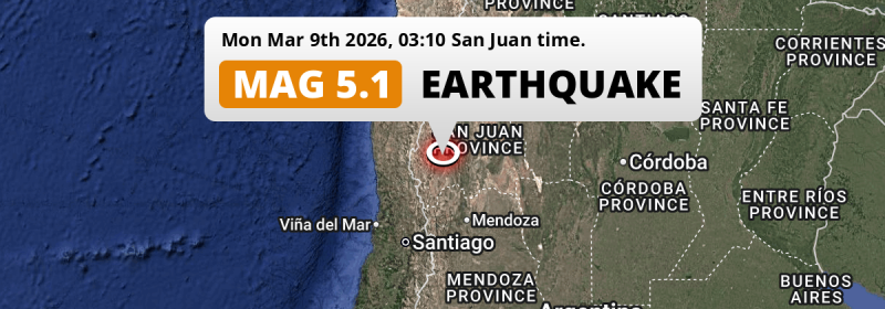
Under land 96 kilometer from San Juan in Argentina, a significant M5.1 earthquake occurred deep in the night of Monday March 9th, 2026. Another nearby country is Chile.
Felt the earthquake? Share this article: 


Earthquake Summary
The earthquake struck on land in Argentina, 96 kilometer (60 mi) west of San Juan. The center of this earthquake had an intermediate depth of 112 km.
| Date and Time: | Mar 9, 2026 03:10 (San Juan Time) - Mar 9, 2026 06:10 Universal Time. |
|---|---|
| Location: | 96 km west of San Juan, Argentina. Coordinates 31°26'46"S 69°32'33"W. |
| Map: | 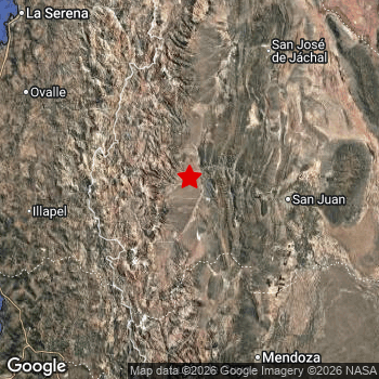 Map of area around epicenter. Click to open in Google Maps. |
| Magnitude: | MAG 5.1 Detected by 82 stations. Maximum Error Range ±0.063 . |
| Depth: | 112 km (69 mi) An intermediate depth. |
| Tsunami Risk: | Tsunami very unlikely Tsunami's are usually caused by MAG-6.5+ earthquakes, less than 100km shallow, and with an epicenter under sea. Neither of this seems to be the case. Always stay cautious - More info here. |
Nearby towns and cities
This earthquake struck within proximity of multiple countries. Argentina and Chile are both within 300km distance of its epicenter.
Located 95 kilometer (59 mi) west of the epicenter of this earthquake, Villa Paula de Sarmiento (San Juan, Argentina) is the nearest significant population center.
Multiple major population centers exist within 300km of the earthquake that struck today. Santiago is located 246 km to the southwest. Mendoza is located 174 km to the south-east. San Juan is located 96 km to the east.
An overview of nearby towns and cities is available in the overview below.
Overview of nearby places
| Distance | Place |
|---|---|
| 95 km (59 mi) E from epicenter |
Villa Paula de Sarmiento San Juan, Argentina. |
| 95 km (59 mi) E from epicenter |
Pocito San Juan, Argentina. |
| 96 km (60 mi) E from epicenter |
San Juan San Juan, Argentina. |
| 96 km (60 mi) E from epicenter |
Albardón San Juan, Argentina. |
| 96 km (60 mi) E from epicenter |
Chimbas San Juan, Argentina. |
| 100 km (62 mi) E from epicenter |
Santa Lucía San Juan, Argentina. |
| 122 km (76 mi) E from epicenter |
Caucete San Juan, Argentina. |
| 154 km (96 mi) NE from epicenter |
San José de Jáchal San Juan, Argentina. |
| 156 km (97 mi) W from epicenter |
Illapel Coquimbo Region, Chile. |
| 174 km (108 mi) SE from epicenter |
Mendoza Mendoza, Argentina. |
| 183 km (114 mi) SW from epicenter |
San Felipe Valparaíso, Chile. |
| 184 km (114 mi) NW from epicenter |
Ovalle Coquimbo Region, Chile. |
| 184 km (114 mi) SW from epicenter |
Los Andes Valparaíso, Chile. |
| 195 km (121 mi) SW from epicenter |
La Ligua Valparaíso, Chile. |
| 204 km (127 mi) SW from epicenter |
Llaillay Valparaíso, Chile. |
| 208 km (129 mi) SE from epicenter |
San Martín Mendoza, Argentina. |
| 217 km (135 mi) SW from epicenter |
Hacienda La Calera Valparaíso, Chile. |
| 227 km (141 mi) SW from epicenter |
Quillota Valparaíso, Chile. |
| 229 km (142 mi) SW from epicenter |
Chicureo Abajo Santiago Metropolitan, Chile. |
| 237 km (147 mi) NW from epicenter |
La Serena Coquimbo Region, Chile. |
| 238 km (148 mi) SW from epicenter |
Limache Valparaíso, Chile. |
| 239 km (149 mi) NW from epicenter |
Coquimbo Coquimbo Region, Chile. |
| 240 km (149 mi) SW from epicenter |
Lampa Santiago Metropolitan, Chile. |
| 246 km (153 mi) SW from epicenter |
Santiago Santiago Metropolitan, Chile. |
| 247 km (153 mi) SW from epicenter |
Villa Alemana Valparaíso, Chile. |
| 248 km (154 mi) SW from epicenter |
Lo Prado Santiago Metropolitan, Chile. |
| 252 km (157 mi) SW from epicenter |
Quilpué Valparaíso, Chile. |
| 258 km (160 mi) SW from epicenter |
Viña del Mar Valparaíso, Chile. |
| 259 km (161 mi) SW from epicenter |
La Pintana Santiago Metropolitan, Chile. |
| 260 km (162 mi) S from epicenter |
Puente Alto Santiago Metropolitan, Chile. |
| 262 km (163 mi) SW from epicenter |
San Bernardo Santiago Metropolitan, Chile. |
| 264 km (164 mi) SW from epicenter |
Valparaíso Valparaíso, Chile. |
| 271 km (168 mi) SW from epicenter |
Peñaflor Santiago Metropolitan, Chile. |
| 278 km (173 mi) SW from epicenter |
Buin Santiago Metropolitan, Chile. |
| 279 km (173 mi) SW from epicenter |
Talagante Santiago Metropolitan, Chile. |
| 283 km (176 mi) SW from epicenter |
El Monte Santiago Metropolitan, Chile. |
| 286 km (178 mi) SW from epicenter |
Paine Santiago Metropolitan, Chile. |
| 295 km (183 mi) SW from epicenter |
Melipilla Santiago Metropolitan, Chile. |
Shaking reported by 5 people in 2 countries
People that feel an earthquake may report their experience to the US Geographic Survey. Currently, 5 people have reported shaking in 3 places in 2 countries (Argentina, Chile).We keep updating this article as more ground reports become available. You may report that you felt this earthquake here.
Places with most reports:
- San Juan, San Juan, Argentina: 2 people.
- Mendoza, Mendoza, Argentina: 2 people.
- La Serena, Coquimbo, Chile: 1 person.
11 Aftershocks detected
Since this main shock, 11 smaller aftershocks were detected. A 3.5 magnitude earthquake hit 2 days later 70 km (44 mi) east of this earthquake.
Before this earthquake struck, 13 smaller foreshocks occurred. Nearby this earthquake a foreshock struck 2 days earlier. It measured a magnitude of 3.3
Overview of foreshocks and aftershocks
| Classification | Magnitude | When | Where |
|---|---|---|---|
| Foreshock | M 3.2 |
3 days earlier Mar 6, 2026 03:24 (San Juan Time) | 82 km (51 mi) NE from Main Shock. |
| Foreshock | M 2.5 |
3 days earlier Mar 6, 2026 10:30 (San Juan Time) | 34 km (21 mi) S from Main Shock. |
| Foreshock | M 2.6 |
2 days earlier Mar 6, 2026 22:43 (San Juan Time) | 94 km (58 mi) E from Main Shock. |
| Foreshock | M 2.6 |
2 days earlier Mar 7, 2026 01:48 (San Juan Time) | 57 km (36 mi) S from Main Shock. |
| Foreshock | M 2.5 |
2 days earlier Mar 7, 2026 09:08 (San Juan Time) | 83 km (51 mi) NW from Main Shock. |
| Foreshock | M 2.5 |
2 days earlier Mar 7, 2026 09:17 (San Juan Time) | 67 km (42 mi) SE from Main Shock. |
| Foreshock | M 3.3 |
2 days earlier Mar 7, 2026 10:55 (San Juan Time) | 61 km (38 mi) E from Main Shock. |
| Foreshock | M 2.5 |
2 days earlier Mar 7, 2026 12:17 (San Juan Time) | 87 km (54 mi) W from Main Shock. |
| Foreshock | M 3.1 |
21 hrs earlier Mar 8, 2026 05:43 (San Juan Time) | 22 km (14 mi) SE from Main Shock. |
| Foreshock | M 2.7 |
21 hrs earlier Mar 8, 2026 06:30 (San Juan Time) | 73 km (46 mi) E from Main Shock. |
| Foreshock | M 2.9 |
20 hrs earlier Mar 8, 2026 07:04 (San Juan Time) | 87 km (54 mi) SW from Main Shock. |
| Foreshock | M 2.8 |
20 hrs earlier Mar 8, 2026 07:33 (San Juan Time) | 37 km (23 mi) SE from Main Shock. |
| Foreshock | M 3.1 |
2 hrs earlier Mar 9, 2026 01:08 (San Juan Time) | 31 km (19 mi) E from Main Shock. |
| Main Shock This Earthquake |
M 5.1 |
Mar 9, 2026 03:10 (San Juan Time) | - |
| Aftershock | M 2.5 |
12 mins later Mar 9, 2026 03:22 (San Juan Time) | 87 km (54 mi) E from Main Shock. |
| Aftershock | M 3.0 |
17 hrs later Mar 9, 2026 20:07 (San Juan Time) | 2.8 km (1.7 mi) S from Main Shock. |
| Aftershock | M 3.0 |
23 hrs later Mar 10, 2026 02:00 (San Juan Time) | 8 km (5 mi) NE from Main Shock. |
| Aftershock | M 3.0 |
24 hrs later Mar 10, 2026 02:47 (San Juan Time) | 41 km (25 mi) SW from Main Shock. |
| Aftershock | M 2.9 |
1 day later Mar 10, 2026 12:55 (San Juan Time) | 44 km (27 mi) S from Main Shock. |
| Aftershock | M 2.7 |
2 days later Mar 11, 2026 00:37 (San Juan Time) | 44 km (27 mi) S from Main Shock. |
| Aftershock | M 3.5 |
2 days later Mar 11, 2026 01:36 (San Juan Time) | 70 km (44 mi) E from Main Shock. |
| Aftershock | M 3.2 |
2 days later Mar 11, 2026 03:35 (San Juan Time) | 65 km (41 mi) W from Main Shock. |
| Aftershock | M 2.5 |
2 days later Mar 11, 2026 09:57 (San Juan Time) | 55 km (34 mi) E from Main Shock. |
| Aftershock | M 2.8 |
2 days later Mar 11, 2026 13:55 (San Juan Time) | 84 km (52 mi) E from Main Shock. |
| Aftershock | M 2.8 |
2 days later Mar 11, 2026 15:08 (San Juan Time) | 74 km (46 mi) E from Main Shock. |
More earthquakes coming?
Aftershocks are usually at least 1 order of magnitude less strong than main shocks. The more time passes, the smaller the chance and likely strength of any potential aftershocks.
In only six percent of cases, significant earthquakes are followed by a larger main shock, making the current earthquake a foreshock. While the chance of this happening is not so large, it is adviced to maintain cautiousness in the hours and days following a major earthquake.
Read: How to Stay Safe during an Earthquake (cdc.gov).Earthquakes like this happen often in the region
Earthquakes of this strength are very common in the region. This is the strongest earthquake to hit since February 12th, 2026, when a 6.2 magnitude earthquake hit 194 km (120 mi) further west. An even stronger magnitude 6.9 earthquake struck on April 24th, 2017.
In total, 75 earthquakes with a magnitude of 5.1 or higher have been registered within 300km (186 mi) of this epicenter in the past 10 years. This comes down to an average of once every 2 months.
Tsunami very unlikely
It is very unlikely that this eartquake will cause any tsunami's. The reported magnitude is lower than the MAG-6.5 strength required to cause any earthquakes. In addition, this earthquake was not very shallow and appears to have occurred under land. However always stay cautious and monitor advice from local authorities.
Tsunami Risk Factors
| Factor | Under Sea? | MAG-6.5 or stronger? | Shallow depth? |
|---|---|---|---|
| Explanation | Almost all tsunami's are caused by earthquakes with their epicenter under sea or very near the sea. However stay cautious in coastal areas as earthquakes on land may cause landslides into sea, potentially still causing a local tsunami. | Under MAG 6.5: Very unlikely to cause a tsunami. MAG 6.5 to 7.5: Destructive tsunami's do occur, but are uncommon. Likely to observe small sea level changes. MAG 7.6+: Earthquakes with these magnitudes might produce destructive tsunami's. |
Most destructive tsunami's are caused by shallow earthquakes with a depth between 0 and 100km under the surface of the earth. Deeper tsunami's are unlikely to displace to ocean floor. |
| This Earthquake | Not this earthquake. This earthquake appears to have struck on land far from any coast. |
Not this earthquake. This earthquake had a magnitude of 5.1. Earthquakes of this strength are unlikely to trigger a tsunami. |
Not this earthquake. This earthquake occurred at a depth of 112 km (69 mi). Earthquakes this deep in the earth are unlikely to trigger a tsunami. |
Sources
Last updated 31/03/26 08:58 (). As more information on this earthquake becomes available this article will be updated. This article is automatically composed based on data originating from multiple sources.
- US Geographic Society (USGS): Earthquake us7000s33f
- European-Mediterranean Seismological Centre (EMSC): Earthquake 20260309_0000094
- Geonames.org: World Cities Database
- Google Maps: Static API
- Earthquakelist.org: Historic Earthquakes Database
Share this article:
