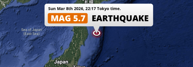
In the evening of Sunday March 8th, 2026, a shallow and significant MAG-5.7 earthquake hit in the North Pacific Ocean 175 kilometer from Morioka, Japan. Around 2.8 million people have been exposed to shaking.
Felt the earthquake? Share this article: 


Earthquake Summary
This earthquake hit under water in the North Pacific Ocean, 123 kilometers (76 mi) off the coast of Japan, 175 kilometer east of Morioka in Iwate. The center of this earthquake had a very shallow depth of 16 km. Shallow earthquakes usually have a larger impact than earthquakes deep in the earth.
| Date and Time: | Mar 8, 2026 22:17 (Tokyo Time) - Mar 8, 2026 13:17 Universal Time. |
|---|---|
| Location: | 175 km east of Morioka, Iwate, Japan. Coordinates 39°26'8"N 143°9'56"E. |
| Map: | 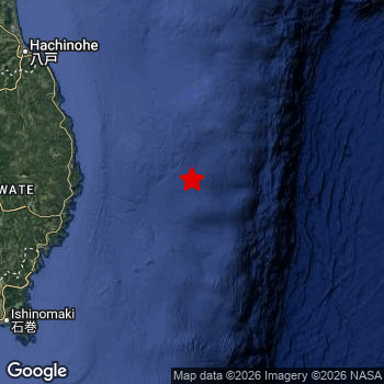 Map of area around epicenter. Click to open in Google Maps. |
| Magnitude: | MAG 5.7 Detected by 27 stations. Maximum Error Range ±0.06 . |
| Depth: | 16 km (10 mi) A very shallow depth. |
| Max. Intensity: | IV
Light On the Modified Mercalli Scale. |
| Tsunami Risk: | Low tsunami risk Earthquakes under MAG-6.5 do not usually cause tsunami's. Always stay cautious - More info here. |
Minimal impact predicted
Based on scientific estimates by the US Geographic Survey (USGS), the risk of high fatalities for this earthquake is classified at level GREEN (low). They expect an 90% likelyhood of between 0 and 1 fatalities.
The USGS classifies the economic impact of this earthquake at level GREEN (low). They expect an 90% likelyhood of between 0 and 1 million US Dollars in economic damage and impact.
Roughly 2.8 million people exposed to shaking
An estimated 2.8 million have been exposed to shaking (An MMI or Modified Mercalli Intensity level II or higher) as a result of this earthquake according scientific estimates published by the USGS.
The highest earthquake impact level for this earthquake is IV, which corresponds with light shaking and likely no damage. Roughly 220 people are expected to be exposed to this level. Intensity level III was experienced by the majority of people (around 2.7 million). In their region, weak shaking and probably no damage can be expected. All exposure to shaking was within the borders of Japan .
| People | MMI Level | Shaking | Damage |
|---|---|---|---|
| 0 | I |
Not noticable | None |
| 88,230 | II |
Very weak | None |
| 2,731,000 | III |
Weak | Probably none |
| 220 | IV |
Light | Likely none |
| 0 | V |
Moderate | Very light |
| 0 | VI |
Strong | Light |
| 0 | VII |
Very Strong | Moderate |
| 0 | VIII |
Severe | Moderate to heavy |
| 0 | IX |
Violent | Heavy |
| 0 | X |
Extreme | Very heavy |
Nearby towns and cities
This earthquake may have been felt in Japan . Yamada in Iwate, Japan is the nearest significant place from the epicenter. The earthquake occurred 104 kilometer (65 mi) east of Yamada. The intensity of shaking and damage in Yamada is estimated to be around level IV on the Modified Mercalli Intensity scale (light shaking, likely no damage).
Multiple major population centers exist within 300km of the earthquake that struck today. Sendai is located 238 km to the southwest (intensity unknown, possibly low). Morioka is located 175 km to the west and experienced an intensity of III (weak shaking, probably no damage). Hachinohe is located 185 km to the northwest and experienced an intensity of III (weak shaking, probably no damage).
An overview of nearby towns and cities is available in the overview below. If places don't have intensity data available, it likely means the experienced impact in those places was fairly small.
Overview of nearby places
| Distance | Place | Intensity (MMI) |
|---|---|---|
| 104 km (65 mi) W from epicenter |
Yamada Iwate, Japan. |
IV
Light |
| 108 km (67 mi) W from epicenter |
Miyako Iwate, Japan. |
III
Weak |
| 113 km (70 mi) W from epicenter |
Kamaishi Iwate, Japan. |
III
Weak |
| 131 km (81 mi) W from epicenter |
Ōfunato Iwate, Japan. |
III
Weak |
| 141 km (88 mi) W from epicenter |
Tōno Iwate, Japan. |
III
Weak |
| 175 km (109 mi) W from epicenter |
Morioka Iwate, Japan. |
III
Weak |
| 176 km (109 mi) W from epicenter |
Hanamaki Iwate, Japan. |
III
Weak |
| 177 km (110 mi) W from epicenter |
Kitakami Iwate, Japan. |
III
Weak |
| 178 km (111 mi) W from epicenter |
Kanegasaki Iwate, Japan. |
III
Weak |
| 178 km (111 mi) W from epicenter |
Mizusawa Iwate, Japan. |
III
Weak |
| 184 km (114 mi) W from epicenter |
Ichinoseki Iwate, Japan. |
III
Weak |
| 185 km (115 mi) NW from epicenter |
Hachinohe Aomori, Japan. |
III
Weak |
| 189 km (117 mi) W from epicenter |
Shizukuishi Iwate, Japan. |
III
Weak |
| 197 km (122 mi) SW from epicenter |
Ishinomaki Miyagi, Japan. |
III
Weak |
| 202 km (126 mi) SW from epicenter |
Wakuya Miyagi, Japan. |
III
Weak |
| 203 km (126 mi) SW from epicenter |
Yamoto Miyagi, Japan. |
III
Weak |
| 205 km (127 mi) NW from epicenter |
Misawa Aomori, Japan. |
III
Weak |
| 208 km (129 mi) SW from epicenter |
Kogota Miyagi, Japan. |
III
Weak |
| 214 km (133 mi) SW from epicenter |
Furukawa Miyagi, Japan. |
III
Weak |
| 217 km (135 mi) SW from epicenter |
Matsushima Miyagi, Japan. |
III
Weak |
| 220 km (137 mi) W from epicenter |
Hanawa Akita, Japan. |
|
| 223 km (139 mi) SW from epicenter |
Shiogama Miyagi, Japan. |
III
Weak |
| 225 km (140 mi) W from epicenter |
Yokote Akita, Japan. |
|
| 226 km (140 mi) SW from epicenter |
Rifu Miyagi, Japan. |
III
Weak |
| 229 km (142 mi) SW from epicenter |
Tomiya Miyagi, Japan. |
|
| 230 km (143 mi) W from epicenter |
Ōmagari Akita, Japan. |
|
| 231 km (144 mi) W from epicenter |
Yuzawa Akita, Japan. |
|
| 238 km (148 mi) SW from epicenter |
Sendai Miyagi, Japan. |
|
| 241 km (150 mi) W from epicenter |
Ōdate Akita, Japan. |
|
| 249 km (155 mi) SW from epicenter |
Iwanuma Miyagi, Japan. |
|
| 254 km (158 mi) SW from epicenter |
Watari Miyagi, Japan. |
|
| 255 km (158 mi) W from epicenter |
Takanosu Akita, Japan. |
|
| 256 km (159 mi) W from epicenter |
Obanazawa Yamagata, Japan. |
|
| 258 km (160 mi) NW from epicenter |
Aomori Aomori, Japan. |
|
| 258 km (160 mi) W from epicenter |
Shinjō Yamagata, Japan. |
|
| 258 km (160 mi) NW from epicenter |
Kuroishi Aomori, Japan. |
|
| 261 km (162 mi) SW from epicenter |
Ōkawara Miyagi, Japan. |
|
| 263 km (163 mi) NW from epicenter |
Hirosaki Aomori, Japan. |
|
| 263 km (163 mi) W from epicenter |
Akita Akita, Japan. |
|
| 264 km (164 mi) NW from epicenter |
Mutsu Aomori, Japan. |
|
| 264 km (164 mi) SW from epicenter |
Higashine Yamagata, Japan. |
|
| 264 km (164 mi) SW from epicenter |
Kakuda Miyagi, Japan. |
|
| 270 km (168 mi) SW from epicenter |
Tendō Yamagata, Japan. |
|
| 272 km (169 mi) SW from epicenter |
Shiroishi Miyagi, Japan. |
|
| 277 km (172 mi) SW from epicenter |
Sagae Yamagata, Japan. |
|
| 277 km (172 mi) NW from epicenter |
Goshogawara Aomori, Japan. |
|
| 277 km (172 mi) SW from epicenter |
Yamagata Yamagata, Japan. |
|
| 281 km (175 mi) W from epicenter |
Noshiro Akita, Japan. |
|
| 288 km (179 mi) SW from epicenter |
Kaminoyama Yamagata, Japan. |
|
| 290 km (180 mi) SW from epicenter |
Hobaramachi Fukushima, Japan. |
|
| 291 km (181 mi) W from epicenter |
Sakata Yamagata, Japan. |
|
| 299 km (186 mi) W from epicenter |
Tsuruoka Yamagata, Japan. |
Earthquake Intensity Map
The intensity in shaking and damage by this earthquake is illustrated through the map below. The highest intensity measured for this earthquake is IV.

Shaking reported by 1 person
People that feel an earthquake may report their experience to the US Geographic Survey. Currently, 1 person has reported shaking in one place in Japan.We keep updating this article as more ground reports become available. You may report that you felt this earthquake here.
Places with most reports:
- Goshogawara, Aomori, Japan: 1 person.
Aftershocks detected
Before this earthquake struck, 3 smaller foreshocks occurred. A 5.4 magnitude earthquake hit 9 mins earlier nearby.
Overview of foreshocks and aftershocks
| Classification | Magnitude | When | Where |
|---|---|---|---|
| Foreshock | M 4.8 |
2 days earlier Mar 7, 2026 05:31 (Tokyo Time) | 96 km (60 mi) SW from Main Shock. |
| Foreshock | M 4.1 |
2 days earlier Mar 7, 2026 05:35 (Tokyo Time) | 97 km (60 mi) SW from Main Shock. |
| Foreshock | M 5.4 |
9 mins earlier Mar 8, 2026 22:08 (Tokyo Time) | 6 km (4 mi) S from Main Shock. |
| Main Shock This Earthquake |
M 5.7 |
Mar 8, 2026 22:17 (Tokyo Time) | - |
More earthquakes coming?
The risk of aftershocks decreases rapidly over time. Usually, aftershocks are at least one order of magnitude lower than a main shock.
In only six percent of cases, significant earthquakes are followed by a larger main shock, making the current earthquake a foreshock. While the chance of this happening is not so large, it is adviced to maintain cautiousness in the hours and days following a major earthquake.
Read: How to Stay Safe during an Earthquake (cdc.gov).Earthquakes like this happen often in the region
Earthquakes of this strength are very common in the region. This is the strongest earthquake to hit since December 31st, 2025, when a 6 magnitude earthquake hit 78 km (48 mi) further north. An even stronger magnitude 7.6 earthquake struck on December 8th, 2025.
In total, 42 earthquakes with a magnitude of 5.7 or higher have been registered within 300km (186 mi) of this epicenter in the past 10 years. This comes down to an average of once every 3 months.
Low tsunami risk
Based on early data it appears this earthquake was not strong enough (lower than MAG-6.5) to be likely to cause destructive tsunami's. However this earthquake appeared to have hit at a shallow depth under sea, so stay cautious and monitor advice from local authorities.
Tsunami Risk Factors
| Factor | Under Sea? | MAG-6.5 or stronger? | Shallow depth? |
|---|---|---|---|
| Explanation | Almost all tsunami's are caused by earthquakes with their epicenter under sea or very near the sea. However stay cautious in coastal areas as earthquakes on land may cause landslides into sea, potentially still causing a local tsunami. | Under MAG 6.5: Very unlikely to cause a tsunami. MAG 6.5 to 7.5: Destructive tsunami's do occur, but are uncommon. Likely to observe small sea level changes. MAG 7.6+: Earthquakes with these magnitudes might produce destructive tsunami's. |
Most destructive tsunami's are caused by shallow earthquakes with a depth between 0 and 100km under the surface of the earth. Deeper tsunami's are unlikely to displace to ocean floor. |
| This Earthquake | This earthquake appears to have struck under the sea. | Not this earthquake. This earthquake had a magnitude of 5.7. Earthquakes of this strength are unlikely to trigger a tsunami. |
This earthquake occurred at a depth of of 16 km (10 mi). Earthquakes this shallow could trigger a tsunami. |
Sources
Last updated 01/04/26 01:08 (). As more information on this earthquake becomes available this article will be updated. This article is automatically composed based on data originating from multiple sources.
- US Geographic Society (USGS): Earthquake us7000s2z5
- European-Mediterranean Seismological Centre (EMSC): Earthquake 20260308_0000202
- Geonames.org: World Cities Database
- Google Maps: Static API
- Earthquakelist.org: Historic Earthquakes Database
Share this article:
