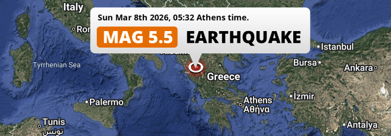
In the early morning of Sunday March 8th, 2026, a shallow and significant MAG-5.5 earthquake hit under land 14 kilometer from Ioánnina in Greece. Earthquakes like this can cause significant economic damage but are usually unlikely to result on large numbers of fatalities. Other nearby countries are Albania, North Macedonia, Italy and Montenegro.
Felt the earthquake? Share this article: 


Earthquake Summary
The earthquake struck on land in Greece, 14 kilometer (9 mi) northwest of Ioánnina in Epirus. The center of this earthquake had a very shallow depth of 10 km. Shallow earthquakes usually have a larger impact than earthquakes deep in the earth.
| Date and Time: | Mar 8, 2026 05:32 (Athens Time) - Mar 8, 2026 03:32 Universal Time. |
|---|---|
| Location: | 14 km NW of Ioánnina, Epirus, Greece. Coordinates 39°43'13"N 20°42'36"E. |
| Map: | 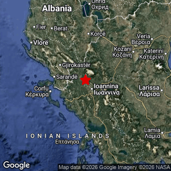 Map of area around epicenter. Click to open in Google Maps. |
| Magnitude: | MAG 5.5 Detected by 50 stations. Maximum Error Range ±0.044 . |
| Depth: | 10 km (6 mi) A very shallow depth. |
| Max. Intensity: | VII
Very Strong On the Modified Mercalli Scale. |
| Tsunami Risk: | Tsunami very unlikely While this was a shallow earthquake, it appears to have occurred under land with a magnitude not strong enough to cause tsunami's. Always stay cautious - More info here. |
Significant economic impact
The US Geographic Survey (USGS) describes the impact of this earthquake as follows:
Many homes destroyed, at least 140 homes damaged and several buildings damaged, landslides and power outages reported in the Dodoni-Ioannina-Seniko area.
Based on scientific estimates by the USGS, the risk of high fatalities for this earthquake is classified at level GREEN (low). They expect an 90% likelyhood of between 0 and 1 fatalities.
The USGS classifies the economic impact of this earthquake at level YELLOW (significant). They expect an 44% likelyhood of between 0 and 1 million US Dollars in economic damage and impact, and a 95% chance that the economic impact of this earthquake falls no higher than 100 million USD.
Roughly 6.8 million people exposed to shaking
This earthquake may have been felt by around 6.8 million people. That is the expected population size of the area exposed to a level of shaking of II or higher on the Modified Mercalli scale according to the USGS.
The highest earthquake impact level for this earthquake is VII, which corresponds with very strong shaking and likely moderate damage. Roughly 4,030 people are expected to be exposed to this level. Intensity level III was experienced by the majority of people (around 3.6 million). In their region, weak shaking and probably no damage can be expected.
People in 6 countries have been exposed to shaking. In Greece , around 3.7 million people, with impact levels up to VII (very strong shaking, likely moderate damage). Roughly 2.5 million people were exposed to shaking in Albania . Roughly 590 thousand people were exposed to shaking in North Macedonia . In Italy, Montenegro and Bulgaria, a smaller number of people were exposed.
| People | MMI Level | Shaking | Damage |
|---|---|---|---|
| 58,370 | I |
Not noticable | None |
| 2,671,000 | II |
Very weak | None |
| 3,627,000 | III |
Weak | Probably none |
| 434,700 | IV |
Light | Likely none |
| 102,400 | V |
Moderate | Very light |
| 10,520 | VI |
Strong | Light |
| 4,030 | VII |
Very Strong | Moderate |
| 0 | VIII |
Severe | Moderate to heavy |
| 0 | IX |
Violent | Heavy |
| 0 | X |
Extreme | Very heavy |
Nearby towns and cities
This earthquake struck within proximity of multiple countries. Greece , Albania , North Macedonia , Italy and Montenegro are all within 300km distance of its epicenter. Futher away, this earthquake may also have been felt in Bulgaria.
Ioánnina in Epirus, Greece is the nearest significant place from the epicenter. The earthquake occurred 14 kilometer (9 mi) northwest of Ioánnina. Ioánnina experienced an earthquake intensity (MMI Scale) of roughly V. That level implies moderate shaking and very light damage.
Multiple large cities are in proximity of today's earthquake. Tirana is located 194 km to the northwest and experienced an intensity of III (weak shaking, probably no damage). Skopje is located 260 km to the north (intensity unknown, possibly low). Thessaloníki is located 215 km to the north-east and experienced an intensity of II (very weak shaking, no damage).
An overview of nearby towns and cities is available in the overview below. If places don't have intensity data available, it likely means the experienced impact in those places was fairly small.
Overview of nearby places
| Distance | Place | Intensity (MMI) |
|---|---|---|
| 14 km (9 mi) SE from epicenter |
Ioánnina Epirus, Greece. |
V
Moderate |
| 63 km (39 mi) NW from epicenter |
Gjirokastër Gjirokastër, Albania. |
III
Weak |
| 63 km (39 mi) W from epicenter |
Sarandë Vlorë, Albania. |
III
Weak |
| 67 km (42 mi) S from epicenter |
Árta Epirus, Greece. |
IV
Light |
| 68 km (42 mi) W from epicenter |
Corfu Ionian Islands, Greece. |
IV
Light |
| 85 km (53 mi) S from epicenter |
Préveza Epirus, Greece. |
IV
Light |
| 92 km (57 mi) E from epicenter |
Tríkala Thessaly, Greece. |
IV
Light |
| 100 km (62 mi) N from epicenter |
Korçë Korçë, Albania. |
III
Weak |
| 111 km (69 mi) E from epicenter |
Kardítsa Thessaly, Greece. |
IV
Light |
| 112 km (70 mi) NE from epicenter |
Kozáni West Macedonia, Greece. |
II
Weak |
| 121 km (75 mi) NE from epicenter |
Ptolemaḯda West Macedonia, Greece. |
III
Weak |
| 127 km (79 mi) NW from epicenter |
Berat Berat, Albania. |
III
Weak |
| 132 km (82 mi) NE from epicenter |
Flórina West Macedonia, Greece. |
II
Weak |
| 132 km (82 mi) N from epicenter |
Pogradec Korçë, Albania. |
III
Weak |
| 133 km (83 mi) NW from epicenter |
Vlorë Vlorë, Albania. |
III
Weak |
| 136 km (85 mi) NW from epicenter |
Patos Fshat Fier, Albania. |
III
Weak |
| 136 km (85 mi) SE from epicenter |
Agrínio West Greece, Greece. |
III
Weak |
| 138 km (86 mi) NW from epicenter |
Kuçovë Berat, Albania. |
III
Weak |
| 142 km (88 mi) NW from epicenter |
Patos Fier, Albania. |
III
Weak |
| 146 km (91 mi) E from epicenter |
Lárisa Thessaly, Greece. |
III
Weak |
| 147 km (91 mi) NW from epicenter |
Fier-Çifçi Fier, Albania. |
III
Weak |
| 148 km (92 mi) NW from epicenter |
Fier Fier, Albania. |
III
Weak |
| 153 km (95 mi) NE from epicenter |
Náousa Central Macedonia, Greece. |
II
Weak |
| 154 km (96 mi) N from epicenter |
Resen Resen, North Macedonia. |
III
Weak |
| 155 km (96 mi) NE from epicenter |
Véroia Central Macedonia, Greece. |
III
Weak |
| 155 km (96 mi) N from epicenter |
Bitola Bitola, North Macedonia. |
III
Weak |
| 156 km (97 mi) N from epicenter |
Ohrid Ohrid, North Macedonia. |
III
Weak |
| 160 km (99 mi) NW from epicenter |
Lushnjë Fier, Albania. |
III
Weak |
| 162 km (101 mi) N from epicenter |
Struga Struga, North Macedonia. |
III
Weak |
| 164 km (102 mi) N from epicenter |
Elbasan Elbasan, Albania. |
III
Weak |
| 165 km (103 mi) E from epicenter |
Kateríni Central Macedonia, Greece. |
III
Weak |
| 165 km (103 mi) NE from epicenter |
Édessa Central Macedonia, Greece. |
II
Weak |
| 174 km (108 mi) SE from epicenter |
Lamía Central Greece, Greece. |
III
Weak |
| 186 km (116 mi) SE from epicenter |
Pátra West Greece, Greece. |
III
Weak |
| 187 km (116 mi) NE from epicenter |
Giannitsá Central Macedonia, Greece. |
II
Weak |
| 190 km (118 mi) NW from epicenter |
Kavajë Tirana, Albania. |
III
Weak |
| 194 km (121 mi) E from epicenter |
Néa Ionía Thessaly, Greece. |
III
Weak |
| 194 km (121 mi) NW from epicenter |
Tirana Tirana, Albania. |
III
Weak |
| 194 km (121 mi) N from epicenter |
Prilep Prilep, North Macedonia. |
III
Weak |
| 196 km (122 mi) E from epicenter |
Volos Thessaly, Greece. |
II
Weak |
| 196 km (122 mi) N from epicenter |
Centar Župa Centar Zhupa, North Macedonia. |
II
Weak |
| 200 km (124 mi) N from epicenter |
Kičevo Kichevo, North Macedonia. |
|
| 201 km (125 mi) N from epicenter |
Debar Debar, North Macedonia. |
|
| 207 km (129 mi) NW from epicenter |
Durrës Durrës, Albania. |
III
Weak |
| 213 km (132 mi) NE from epicenter |
Kalamariá Central Macedonia, Greece. |
II
Weak |
| 215 km (134 mi) NE from epicenter |
Thessaloníki Central Macedonia, Greece. |
II
Weak |
| 218 km (135 mi) N from epicenter |
Burrel Dibër, Albania. |
|
| 219 km (136 mi) NE from epicenter |
Gevgelija Gevgelija, North Macedonia. |
II
Weak |
| 220 km (137 mi) NE from epicenter |
Kavadarci Kavadarci, North Macedonia. |
II
Weak |
| 227 km (141 mi) W from epicenter |
Lecce Apulia, Italy. |
|
| 228 km (142 mi) NE from epicenter |
Negotino Negotino, North Macedonia. |
III
Weak |
| 229 km (142 mi) N from epicenter |
Laç Lezhë, Albania. |
|
| 231 km (144 mi) N from epicenter |
Gostivar Gostivar, North Macedonia. |
|
| 239 km (149 mi) N from epicenter |
Veles Veles, North Macedonia. |
|
| 240 km (149 mi) N from epicenter |
Negotino Vrapchishte, North Macedonia. |
|
| 246 km (153 mi) N from epicenter |
Bogovinje Bogovinje, North Macedonia. |
|
| 251 km (156 mi) N from epicenter |
Brvenica Bervenices, North Macedonia. |
|
| 251 km (156 mi) NE from epicenter |
Strumica Strumica, North Macedonia. |
II
Weak |
| 253 km (157 mi) N from epicenter |
Zelino Zhelino, North Macedonia. |
|
| 254 km (158 mi) N from epicenter |
Studeničani Studeničani, North Macedonia. |
|
| 256 km (159 mi) N from epicenter |
Tetovo Tetovo, North Macedonia. |
|
| 257 km (160 mi) NW from epicenter |
Brindisi Apulia, Italy. |
|
| 258 km (160 mi) NE from epicenter |
Shtip Shtip, North Macedonia. |
|
| 260 km (162 mi) NE from epicenter |
Radovis Radovish, North Macedonia. |
|
| 260 km (162 mi) N from epicenter |
Skopje Grad Skopje, North Macedonia. |
|
| 263 km (163 mi) N from epicenter |
Ilinden Ilinden, North Macedonia. |
|
| 263 km (163 mi) N from epicenter |
Kukës Kukës, Albania. |
|
| 264 km (164 mi) N from epicenter |
Tearce Tearce, North Macedonia. |
|
| 277 km (172 mi) SE from epicenter |
Kórinthos Peloponnese, Greece. |
II
Weak |
| 277 km (172 mi) N from epicenter |
Prizren Prizren District, Kosovo. |
|
| 280 km (174 mi) N from epicenter |
Shkodër Shkodër, Albania. |
|
| 281 km (175 mi) N from epicenter |
Lipkovo Lipkovo, North Macedonia. |
|
| 281 km (175 mi) N from epicenter |
Kumanovo Kumanovo, North Macedonia. |
|
| 282 km (175 mi) NE from epicenter |
Petrich Blagoevgrad, Bulgaria. |
|
| 283 km (176 mi) NE from epicenter |
Kochani Kochani, North Macedonia. |
|
| 284 km (176 mi) NE from epicenter |
Vinica Vinica, North Macedonia. |
|
| 294 km (183 mi) N from epicenter |
Vitina Gjilan District, Kosovo. |
|
| 297 km (185 mi) N from epicenter |
Gjakovë Gjakova District, Kosovo. |
|
| 297 km (185 mi) N from epicenter |
Ferizaj Ferizaj District, Kosovo. |
|
| 297 km (185 mi) NW from epicenter |
Bar Bar, Montenegro. |
|
| 298 km (185 mi) SE from epicenter |
Mégara Attica, Greece. |
Earthquake Intensity Map
The graph below overlays a map of the region around the epicenter with earthquake intensity data provided by the US Geographic Survey. The highest intensity level detected for this earthquake is VII.

Shaking reported by 23 people in 2 countries
People that feel an earthquake may report their experience to the US Geographic Survey. Currently, 23 people have reported shaking in 12 places in 2 countries (Greece, Albania).We keep updating this article as more ground reports become available. You may report that you felt this earthquake here.
Places with most reports:
- Ioánnina, Ioánnina, Greece: 5 people.
- Vlorë, Vlorë, Albania: 5 people.
- Zítsa, Ioánnina, Greece: 2 people.
- Neokhorópoulon, Ioánnina, Greece: 2 people.
- Auliótai, Kérkira, Greece: 2 people.
- Pediní, Ioánnina, Greece: 1 person.
- Rodotópion, Ioánnina, Greece: 1 person.
- Anatolí, Ioánnina, Greece: 1 person.
- Tsiflikópoulon, Ioánnina, Greece: 1 person.
- Sarandë, Sarandë, Albania: 1 person.
51 Aftershocks detected
Since this main shock, 51 smaller aftershocks were detected. At a distance of 13 km (8 mi) southwest of this earthquake, an aftershock struck 4 mins later. It measured a magnitude of 4.7
In the days before this main shock, 2 smaller foreshocks were detected. Roughly 3 days before this earthquake, a foreshock measuring MAG-3.1 was detected nearby this earthquake.
Overview of foreshocks and aftershocks
| Classification | Magnitude | When | Where |
|---|---|---|---|
| Foreshock | M 3.1 |
3 days earlier Mar 5, 2026 06:35 (Athens Time) | 85 km (53 mi) W from Main Shock. |
| Foreshock | M 2.7 |
2 days earlier Mar 6, 2026 14:17 (Athens Time) | 47 km (29 mi) W from Main Shock. |
| Main Shock This Earthquake |
M 5.5 |
Mar 8, 2026 05:32 (Athens Time) | - |
| Aftershock | M 4.7 |
4 mins later Mar 8, 2026 05:36 (Athens Time) | 13 km (8 mi) SW from Main Shock. |
| Aftershock | M 3.6 |
7 mins later Mar 8, 2026 05:39 (Athens Time) | 13 km (8 mi) SW from Main Shock. |
| Aftershock | M 3.4 |
9 mins later Mar 8, 2026 05:41 (Athens Time) | 16 km (10 mi) SW from Main Shock. |
| Aftershock | M 2.8 |
12 mins later Mar 8, 2026 05:44 (Athens Time) | 11 km (7 mi) SW from Main Shock. |
| Aftershock | M 2.9 |
13 mins later Mar 8, 2026 05:45 (Athens Time) | 15 km (10 mi) SW from Main Shock. |
| Aftershock | M 2.7 |
31 mins later Mar 8, 2026 06:03 (Athens Time) | 8 km (5 mi) W from Main Shock. |
| Aftershock | M 3.1 |
33 mins later Mar 8, 2026 06:05 (Athens Time) | 8 km (5 mi) SW from Main Shock. |
| Aftershock | M 3.4 |
42 mins later Mar 8, 2026 06:14 (Athens Time) | 16 km (10 mi) S from Main Shock. |
| Aftershock | M 2.8 |
44 mins later Mar 8, 2026 06:16 (Athens Time) | 8 km (5 mi) SW from Main Shock. |
| Aftershock | M 3.5 |
47 mins later Mar 8, 2026 06:19 (Athens Time) | 9 km (5 mi) SW from Main Shock. |
| Aftershock | M 3.2 |
1 hr later Mar 8, 2026 06:37 (Athens Time) | 9 km (5 mi) SW from Main Shock. |
| Aftershock | M 2.6 |
1 hr later Mar 8, 2026 06:51 (Athens Time) | 12 km (8 mi) SW from Main Shock. |
| Aftershock | M 2.7 |
1 hr later Mar 8, 2026 06:58 (Athens Time) | 14 km (9 mi) S from Main Shock. |
| Aftershock | M 2.5 |
2 hrs later Mar 8, 2026 07:42 (Athens Time) | 11 km (7 mi) SW from Main Shock. |
| Aftershock | M 2.6 |
2 hrs later Mar 8, 2026 07:46 (Athens Time) | 16 km (10 mi) S from Main Shock. |
| Aftershock | M 2.7 |
2 hrs later Mar 8, 2026 07:47 (Athens Time) | 15 km (10 mi) S from Main Shock. |
| Aftershock | M 3.1 |
2 hrs later Mar 8, 2026 08:01 (Athens Time) | 16 km (10 mi) SW from Main Shock. |
| Aftershock | M 2.8 |
3 hrs later Mar 8, 2026 08:02 (Athens Time) | 15 km (10 mi) SW from Main Shock. |
| Aftershock | M 3.0 |
3 hrs later Mar 8, 2026 08:20 (Athens Time) | 15 km (9 mi) S from Main Shock. |
| Aftershock | M 2.9 |
4 hrs later Mar 8, 2026 09:02 (Athens Time) | 9 km (5 mi) SW from Main Shock. |
| Aftershock | M 2.6 |
4 hrs later Mar 8, 2026 09:14 (Athens Time) | 12 km (8 mi) SW from Main Shock. |
| Aftershock | M 3.0 |
4 hrs later Mar 8, 2026 09:59 (Athens Time) | 16 km (10 mi) SW from Main Shock. |
| Aftershock | M 2.9 |
6 hrs later Mar 8, 2026 11:20 (Athens Time) | 14 km (9 mi) SW from Main Shock. |
| Aftershock | M 3.2 |
6 hrs later Mar 8, 2026 11:33 (Athens Time) | 12 km (7 mi) SW from Main Shock. |
| Aftershock | M 2.7 |
6 hrs later Mar 8, 2026 11:53 (Athens Time) | 15 km (9 mi) SW from Main Shock. |
| Aftershock | M 3.0 |
8 hrs later Mar 8, 2026 13:40 (Athens Time) | 15 km (10 mi) S from Main Shock. |
| Aftershock | M 2.8 |
9 hrs later Mar 8, 2026 14:48 (Athens Time) | 17 km (10 mi) S from Main Shock. |
| Aftershock | M 3.1 |
9 hrs later Mar 8, 2026 14:50 (Athens Time) | 17 km (11 mi) S from Main Shock. |
| Aftershock | M 2.6 |
10 hrs later Mar 8, 2026 15:20 (Athens Time) | 10 km (6 mi) SW from Main Shock. |
| Aftershock | M 3.0 |
10 hrs later Mar 8, 2026 15:37 (Athens Time) | 15 km (9 mi) S from Main Shock. |
| Aftershock | M 3.0 |
10 hrs later Mar 8, 2026 15:41 (Athens Time) | 17 km (10 mi) S from Main Shock. |
| Aftershock | M 3.2 |
10 hrs later Mar 8, 2026 15:42 (Athens Time) | 15 km (9 mi) S from Main Shock. |
| Aftershock | M 2.7 |
10 hrs later Mar 8, 2026 15:49 (Athens Time) | 16 km (10 mi) S from Main Shock. |
| Aftershock | M 3.2 |
11 hrs later Mar 8, 2026 16:17 (Athens Time) | 15 km (9 mi) SW from Main Shock. |
| Aftershock | M 3.4 |
11 hrs later Mar 8, 2026 16:29 (Athens Time) | 17 km (11 mi) S from Main Shock. |
| Aftershock | M 2.6 |
11 hrs later Mar 8, 2026 16:31 (Athens Time) | 16 km (10 mi) SW from Main Shock. |
| Aftershock | M 3.9 |
11 hrs later Mar 8, 2026 17:02 (Athens Time) | 9 km (5 mi) SW from Main Shock. |
| Aftershock | M 3.3 |
13 hrs later Mar 8, 2026 18:53 (Athens Time) | 16 km (10 mi) S from Main Shock. |
| Aftershock | M 3.1 |
16 hrs later Mar 8, 2026 21:19 (Athens Time) | 18 km (11 mi) S from Main Shock. |
| Aftershock | M 3.7 |
18 hrs later Mar 8, 2026 23:17 (Athens Time) | 15 km (9 mi) SW from Main Shock. |
| Aftershock | M 2.6 |
22 hrs later Mar 9, 2026 03:07 (Athens Time) | 14 km (9 mi) SW from Main Shock. |
| Aftershock | M 2.5 |
23 hrs later Mar 9, 2026 04:30 (Athens Time) | 8 km (5 mi) SW from Main Shock. |
| Aftershock | M 2.5 |
1 day later Mar 9, 2026 06:19 (Athens Time) | 15 km (9 mi) SW from Main Shock. |
| Aftershock | M 3.2 |
1 day later Mar 9, 2026 08:46 (Athens Time) | 17 km (11 mi) SW from Main Shock. |
| Aftershock | M 2.6 |
1 day later Mar 9, 2026 09:15 (Athens Time) | 18 km (11 mi) SW from Main Shock. |
| Aftershock | M 2.5 |
2 days later Mar 9, 2026 19:00 (Athens Time) | 14 km (9 mi) SW from Main Shock. |
| Aftershock | M 3.1 |
2 days later Mar 9, 2026 20:31 (Athens Time) | 13 km (8 mi) S from Main Shock. |
| Aftershock | M 2.8 |
2 days later Mar 10, 2026 14:52 (Athens Time) | 12 km (8 mi) SW from Main Shock. |
| Aftershock | M 2.6 |
2 days later Mar 10, 2026 15:29 (Athens Time) | 18 km (11 mi) S from Main Shock. |
| Aftershock | M 2.7 |
3 days later Mar 10, 2026 18:22 (Athens Time) | 13 km (8 mi) SW from Main Shock. |
| Aftershock | M 2.9 |
3 days later Mar 11, 2026 01:20 (Athens Time) | 16 km (10 mi) S from Main Shock. |
More earthquakes coming?
Aftershocks are usually at least 1 order of magnitude less strong than main shocks. The more time passes, the smaller the chance and likely strength of any potential aftershocks.
In only six percent of cases, significant earthquakes are followed by a larger main shock, making the current earthquake a foreshock. While the chance of this happening is not so large, it is adviced to maintain cautiousness in the hours and days following a major earthquake.
Read: How to Stay Safe during an Earthquake (cdc.gov).Earthquakes like this happen often in the region
Earthquakes of this strength are very common in the region. This is the strongest earthquake to hit since March 29th, 2024, when a 5.8 magnitude earthquake hit 271 km (168 mi) further south. An even stronger magnitude 6.8 earthquake struck on October 25th, 2018.
In total, 15 earthquakes with a magnitude of 5.5 or higher have been registered within 300km (186 mi) of this epicenter in the past 10 years. This comes down to an average of once every 8 months.
Tsunami very unlikely
While MAG-6.5+ earthquakes may cause tsunami's, it appears that the epicenter of this earthquake hit under land. In addition, the reported depth is deeper than 100km, making the risk of a tsunami even less likely. However always stay cautious and monitor advice from local authorities.
Tsunami Risk Factors
| Factor | Under Sea? | MAG-6.5 or stronger? | Shallow depth? |
|---|---|---|---|
| Explanation | Almost all tsunami's are caused by earthquakes with their epicenter under sea or very near the sea. However stay cautious in coastal areas as earthquakes on land may cause landslides into sea, potentially still causing a local tsunami. | Under MAG 6.5: Very unlikely to cause a tsunami. MAG 6.5 to 7.5: Destructive tsunami's do occur, but are uncommon. Likely to observe small sea level changes. MAG 7.6+: Earthquakes with these magnitudes might produce destructive tsunami's. |
Most destructive tsunami's are caused by shallow earthquakes with a depth between 0 and 100km under the surface of the earth. Deeper tsunami's are unlikely to displace to ocean floor. |
| This Earthquake | Not this earthquake. This earthquake appears to have struck on land far from any coast. |
Not this earthquake. This earthquake had a magnitude of 5.5. Earthquakes of this strength are unlikely to trigger a tsunami. |
This earthquake occurred at a depth of of 10 km (6 mi). Earthquakes this shallow could trigger a tsunami. |
Sources
Last updated 01/04/26 01:08 (). As more information on this earthquake becomes available this article will be updated. This article is automatically composed based on data originating from multiple sources.
- US Geographic Society (USGS): Earthquake us7000s2x6
- European-Mediterranean Seismological Centre (EMSC): Earthquake 20260308_0000045
- Geonames.org: World Cities Database
- Google Maps: Static API
- Earthquakelist.org: Historic Earthquakes Database
Share this article:
