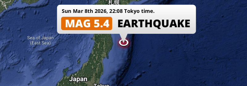
In the evening of Sunday March 8th, 2026, a shallow and significant Magnitude 5.4 foreshock hit in the North Pacific Ocean 178 kilometer from Morioka, Japan. Shaking may have been felt by a total of 2.6 million people.
Felt the earthquake? Share this article: 


Earthquake Summary
This earthquake hit under water in the North Pacific Ocean, 125 kilometers (78 mi) off the coast of Japan, 178 kilometer east of Morioka in Iwate. The center of this earthquake had a very shallow depth of 16 km. Shallow earthquakes usually have a larger impact than earthquakes deep in the earth.
| Date and Time: | Mar 8, 2026 22:08 (Tokyo Time) - Mar 8, 2026 13:08 Universal Time. |
|---|---|
| Location: | 178 km east of Morioka, Iwate, Japan. Coordinates 39°23'10"N 143°11'10"E. |
| Map: | 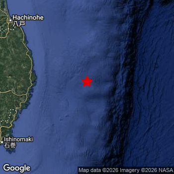 Map of area around epicenter. Click to open in Google Maps. |
| Magnitude: | MAG 5.4 Detected by 23 stations. Maximum Error Range ±0.065 . |
| Depth: | 16 km (10 mi) A very shallow depth. |
| Max. Intensity: | IV
Light On the Modified Mercalli Scale. |
| Tsunami Risk: | Low tsunami risk Earthquakes under MAG-6.5 do not usually cause tsunami's. Always stay cautious - More info here. |
Minimal impact predicted
Based on scientific estimates by the US Geographic Survey (USGS), the risk of high fatalities for this earthquake is classified at level GREEN (low). They expect an 90% likelyhood of between 0 and 1 fatalities.
The USGS classifies the economic impact of this earthquake at level GREEN (low). They expect an 90% likelyhood of between 0 and 1 million US Dollars in economic damage and impact.
Roughly 2.6 million people exposed to shaking
An estimated 2.6 million have been exposed to shaking (An MMI or Modified Mercalli Intensity level II or higher) as a result of this earthquake according scientific estimates published by the USGS.
Weak shaking and probably no damage may have been experienced by an estimated 2,224,000 people. At III, it is the highest MMI level this earthquake has caused. All exposure to shaking was within the borders of Japan .
| People | MMI Level | Shaking | Damage |
|---|---|---|---|
| 0 | I |
Not noticable | None |
| 415,200 | II |
Very weak | None |
| 2,224,000 | III |
Weak | Probably none |
| 0 | IV |
Light | Likely none |
| 0 | V |
Moderate | Very light |
| 0 | VI |
Strong | Light |
| 0 | VII |
Very Strong | Moderate |
| 0 | VIII |
Severe | Moderate to heavy |
| 0 | IX |
Violent | Heavy |
| 0 | X |
Extreme | Very heavy |
Nearby towns and cities
This earthquake may have been felt in Japan . The closest significant population center near the earthquake is Yamada in Iwate, Japan. Yamada is located 107 kilometer (66 mi) east of the epicenter. Yamada experienced an earthquake intensity (MMI Scale) of roughly IV. That level implies light shaking and likely no damage.
Multiple large cities are in proximity of today's earthquake. Sendai is located 236 km to the southwest (intensity unknown, possibly low). Morioka is located 178 km to the west and experienced an intensity of III (weak shaking, probably no damage). Hachinohe is located 190 km to the northwest and experienced an intensity of III (weak shaking, probably no damage).
A complete list of nearby places is included below. Estimated intensity data (MMI) sourced from a shake-map published by the US Geographic Survey is shown where available (cities without data probably experienced little impact).
Overview of nearby places
| Distance | Place | Intensity (MMI) |
|---|---|---|
| 107 km (66 mi) W from epicenter |
Yamada Iwate, Japan. |
IV
Light |
| 111 km (69 mi) W from epicenter |
Miyako Iwate, Japan. |
III
Weak |
| 114 km (71 mi) W from epicenter |
Kamaishi Iwate, Japan. |
III
Weak |
| 131 km (81 mi) W from epicenter |
Ōfunato Iwate, Japan. |
III
Weak |
| 142 km (88 mi) W from epicenter |
Tōno Iwate, Japan. |
III
Weak |
| 178 km (111 mi) W from epicenter |
Morioka Iwate, Japan. |
III
Weak |
| 178 km (111 mi) W from epicenter |
Kitakami Iwate, Japan. |
III
Weak |
| 178 km (111 mi) W from epicenter |
Hanamaki Iwate, Japan. |
III
Weak |
| 179 km (111 mi) W from epicenter |
Kanegasaki Iwate, Japan. |
III
Weak |
| 179 km (111 mi) W from epicenter |
Mizusawa Iwate, Japan. |
III
Weak |
| 185 km (115 mi) W from epicenter |
Ichinoseki Iwate, Japan. |
III
Weak |
| 190 km (118 mi) NW from epicenter |
Hachinohe Aomori, Japan. |
III
Weak |
| 192 km (119 mi) W from epicenter |
Shizukuishi Iwate, Japan. |
III
Weak |
| 196 km (122 mi) SW from epicenter |
Ishinomaki Miyagi, Japan. |
III
Weak |
| 201 km (125 mi) SW from epicenter |
Wakuya Miyagi, Japan. |
III
Weak |
| 201 km (125 mi) SW from epicenter |
Yamoto Miyagi, Japan. |
III
Weak |
| 207 km (129 mi) SW from epicenter |
Kogota Miyagi, Japan. |
III
Weak |
| 210 km (130 mi) NW from epicenter |
Misawa Aomori, Japan. |
III
Weak |
| 213 km (132 mi) SW from epicenter |
Furukawa Miyagi, Japan. |
III
Weak |
| 216 km (134 mi) SW from epicenter |
Matsushima Miyagi, Japan. |
II
Weak |
| 221 km (137 mi) SW from epicenter |
Shiogama Miyagi, Japan. |
III
Weak |
| 223 km (139 mi) NW from epicenter |
Hanawa Akita, Japan. |
|
| 224 km (139 mi) SW from epicenter |
Rifu Miyagi, Japan. |
II
Weak |
| 227 km (141 mi) W from epicenter |
Yokote Akita, Japan. |
|
| 228 km (142 mi) SW from epicenter |
Tomiya Miyagi, Japan. |
|
| 232 km (144 mi) W from epicenter |
Ōmagari Akita, Japan. |
|
| 232 km (144 mi) W from epicenter |
Yuzawa Akita, Japan. |
|
| 236 km (147 mi) SW from epicenter |
Sendai Miyagi, Japan. |
|
| 245 km (152 mi) NW from epicenter |
Ōdate Akita, Japan. |
|
| 247 km (153 mi) SW from epicenter |
Iwanuma Miyagi, Japan. |
|
| 252 km (157 mi) SW from epicenter |
Watari Miyagi, Japan. |
|
| 256 km (159 mi) W from epicenter |
Obanazawa Yamagata, Japan. |
|
| 259 km (161 mi) SW from epicenter |
Ōkawara Miyagi, Japan. |
|
| 259 km (161 mi) W from epicenter |
Shinjō Yamagata, Japan. |
|
| 262 km (163 mi) NW from epicenter |
Kuroishi Aomori, Japan. |
|
| 262 km (163 mi) SW from epicenter |
Kakuda Miyagi, Japan. |
|
| 262 km (163 mi) NW from epicenter |
Aomori Aomori, Japan. |
|
| 263 km (163 mi) SW from epicenter |
Higashine Yamagata, Japan. |
|
| 266 km (165 mi) W from epicenter |
Akita Akita, Japan. |
|
| 267 km (166 mi) NW from epicenter |
Hirosaki Aomori, Japan. |
|
| 269 km (167 mi) SW from epicenter |
Tendō Yamagata, Japan. |
|
| 270 km (168 mi) NW from epicenter |
Mutsu Aomori, Japan. |
|
| 271 km (168 mi) SW from epicenter |
Shiroishi Miyagi, Japan. |
|
| 276 km (171 mi) SW from epicenter |
Yamagata Yamagata, Japan. |
|
| 276 km (171 mi) SW from epicenter |
Sagae Yamagata, Japan. |
|
| 282 km (175 mi) NW from epicenter |
Goshogawara Aomori, Japan. |
|
| 285 km (177 mi) W from epicenter |
Noshiro Akita, Japan. |
|
| 287 km (178 mi) SW from epicenter |
Kaminoyama Yamagata, Japan. |
|
| 292 km (181 mi) W from epicenter |
Sakata Yamagata, Japan. |
|
| 298 km (185 mi) SW from epicenter |
Fukushima Fukushima, Japan. |
|
| 300 km (186 mi) W from epicenter |
Tsuruoka Yamagata, Japan. |
Earthquake Intensity Map
The graph below overlays a map of the region around the epicenter with earthquake intensity data provided by the US Geographic Survey. The highest intensity level detected for this earthquake is IV.

Shaking reported by 1 person
People that feel an earthquake may report their experience to the US Geographic Survey. Currently, 1 person has reported shaking in one place in Japan.We keep updating this article as more ground reports become available. You may report that you felt this earthquake here.
Places with most reports:
- Sendai, Miyagi, Japan: 1 person.
This is likely a foreshock
This earthquake was followed by a stronger MAG-5.7 earthquake, classifying this earthquake as a foreshock.
Overview of foreshocks and aftershocks
| Classification | Magnitude | When | Where |
|---|---|---|---|
| Foreshock | M 4.8 |
2 days earlier Mar 7, 2026 05:31 (Tokyo Time) | 96 km (60 mi) SW from Main Shock. |
| Foreshock | M 4.1 |
2 days earlier Mar 7, 2026 05:35 (Tokyo Time) | 97 km (60 mi) SW from Main Shock. |
| Foreshock This Earthquake |
M 5.4 |
9 mins earlier Mar 8, 2026 22:08 (Tokyo Time) | 6 km (4 mi) S from Main Shock. |
| Main Shock | M 5.7 |
Mar 8, 2026 22:17 (Tokyo Time) | - |
More earthquakes coming?
Aftershocks are usually at least 1 order of magnitude less strong than main shocks. The more time passes, the smaller the chance and likely strength of any potential aftershocks.
In only six percent of cases, significant earthquakes are followed by a larger main shock, making the current earthquake a foreshock. While the chance of this happening is not so large, it is adviced to maintain cautiousness in the hours and days following a major earthquake.
Read: How to Stay Safe during an Earthquake (cdc.gov).Earthquakes like this happen often in the region
Earthquakes of this strength are very common in the region. This is the strongest earthquake to hit since December 31st, 2025, when a 6 magnitude earthquake hit 84 km (52 mi) further north. An even stronger magnitude 7.6 earthquake struck on December 8th, 2025.
In total, 90 earthquakes with a magnitude of 5.4 or higher have been registered within 300km (186 mi) of this epicenter in the past 10 years. This comes down to an average of once every month.
Low tsunami risk
Based on early data it appears this earthquake was not strong enough (lower than MAG-6.5) to be likely to cause destructive tsunami's. However this earthquake appeared to have hit at a shallow depth under sea, so stay cautious and monitor advice from local authorities.
Tsunami Risk Factors
| Factor | Under Sea? | MAG-6.5 or stronger? | Shallow depth? |
|---|---|---|---|
| Explanation | Almost all tsunami's are caused by earthquakes with their epicenter under sea or very near the sea. However stay cautious in coastal areas as earthquakes on land may cause landslides into sea, potentially still causing a local tsunami. | Under MAG 6.5: Very unlikely to cause a tsunami. MAG 6.5 to 7.5: Destructive tsunami's do occur, but are uncommon. Likely to observe small sea level changes. MAG 7.6+: Earthquakes with these magnitudes might produce destructive tsunami's. |
Most destructive tsunami's are caused by shallow earthquakes with a depth between 0 and 100km under the surface of the earth. Deeper tsunami's are unlikely to displace to ocean floor. |
| This Earthquake | This earthquake appears to have struck under the sea. | Not this earthquake. This earthquake had a magnitude of 5.4. Earthquakes of this strength are unlikely to trigger a tsunami. |
This earthquake occurred at a depth of of 16 km (10 mi). Earthquakes this shallow could trigger a tsunami. |
Sources
Last updated 01/04/26 01:08 (). This article is automatically generated based on available data. We keep checking multiple sources for additional information. This article gets updated as new details on this earthquake become available.
- US Geographic Society (USGS): Earthquake us7000s2z4
- European-Mediterranean Seismological Centre (EMSC): Earthquake 20260308_0000200
- Geonames.org: World Cities Database
- Google Maps: Static API
- Earthquakelist.org: Historic Earthquakes Database
Share this article:
