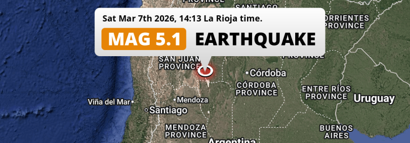
A significant MAG-5.1 earthquake struck under land 157 kilometer from San Juan in Argentina in the afternoon of Saturday March 7th, 2026.
Felt the earthquake? Share this article: 


Earthquake Summary
The earthquake struck on land in Argentina, 157 kilometer (98 mi) east of San Juan. The center of this earthquake had an intermediate depth of 131 km.
| Date and Time: | Mar 7, 2026 14:13 (San Juan Time) - Mar 7, 2026 17:13 Universal Time. |
|---|---|
| Location: | 157 km east of San Juan, Argentina. Coordinates 31°33'37"S 66°52'57"W. |
| Map: | 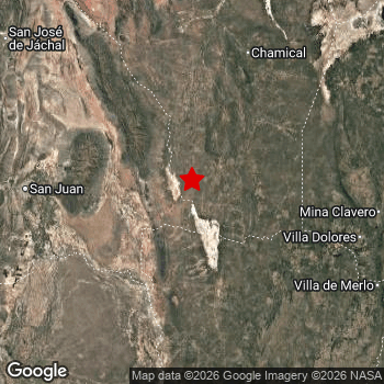 Map of area around epicenter. Click to open in Google Maps. |
| Magnitude: | MAG 5.1 Detected by 25 stations. Maximum Error Range ±0.062 . |
| Depth: | 131 km (81 mi) An intermediate depth. |
| Tsunami Risk: | Tsunami very unlikely Tsunami's are usually caused by MAG-6.5+ earthquakes, less than 100km shallow, and with an epicenter under sea. Neither of this seems to be the case. Always stay cautious - More info here. |
Nearby towns and cities
This earthquake may have been felt in Argentina . Caucete in San Juan, Argentina is the nearest significant place from the epicenter. The earthquake occurred 133 kilometer (83 mi) east of Caucete.
Multiple large cities are in proximity of today's earthquake. Córdoba is located 257 km to the east. Mendoza is located 235 km to the southwest. San Juan is located 157 km to the west.
The table below provides an overview of all places in proximity of today's earthquake.
Overview of nearby places
| Distance | Place |
|---|---|
| 133 km (83 mi) W from epicenter |
Caucete San Juan, Argentina. |
| 153 km (95 mi) W from epicenter |
Santa Lucía San Juan, Argentina. |
| 156 km (97 mi) W from epicenter |
Albardón San Juan, Argentina. |
| 157 km (98 mi) W from epicenter |
San Juan San Juan, Argentina. |
| 157 km (98 mi) W from epicenter |
Villa Paula de Sarmiento San Juan, Argentina. |
| 157 km (98 mi) W from epicenter |
Chimbas San Juan, Argentina. |
| 162 km (101 mi) W from epicenter |
Pocito San Juan, Argentina. |
| 166 km (103 mi) E from epicenter |
Villa Dolores Cordoba, Argentina. |
| 200 km (124 mi) S from epicenter |
San Luis San Luis, Argentina. |
| 218 km (135 mi) NE from epicenter |
Cruz del Eje Cordoba, Argentina. |
| 225 km (140 mi) SW from epicenter |
San Martín Mendoza, Argentina. |
| 227 km (141 mi) E from epicenter |
Villa Carlos Paz Cordoba, Argentina. |
| 231 km (144 mi) NW from epicenter |
San José de Jáchal San Juan, Argentina. |
| 232 km (144 mi) E from epicenter |
Cosquín Cordoba, Argentina. |
| 233 km (145 mi) E from epicenter |
Alta Gracia Cordoba, Argentina. |
| 233 km (145 mi) E from epicenter |
La Falda Cordoba, Argentina. |
| 235 km (146 mi) SW from epicenter |
Mendoza Mendoza, Argentina. |
| 239 km (149 mi) N from epicenter |
La Rioja La Rioja, Argentina. |
| 243 km (151 mi) E from epicenter |
Embalse Cordoba, Argentina. |
| 243 km (151 mi) E from epicenter |
La Calera Cordoba, Argentina. |
| 246 km (153 mi) E from epicenter |
Unquillo Cordoba, Argentina. |
| 247 km (153 mi) E from epicenter |
Río Ceballos Cordoba, Argentina. |
| 247 km (153 mi) E from epicenter |
Villa Allende Cordoba, Argentina. |
| 257 km (160 mi) E from epicenter |
Córdoba Cordoba, Argentina. |
| 270 km (168 mi) SE from epicenter |
Villa Mercedes San Luis, Argentina. |
| 270 km (168 mi) E from epicenter |
Río Tercero Cordoba, Argentina. |
| 273 km (170 mi) E from epicenter |
Jesús María Cordoba, Argentina. |
| 273 km (170 mi) N from epicenter |
Chilecito La Rioja, Argentina. |
| 273 km (170 mi) NE from epicenter |
Deán Funes Cordoba, Argentina. |
| 282 km (175 mi) E from epicenter |
Río Segundo Cordoba, Argentina. |
| 295 km (183 mi) SE from epicenter |
Río Cuarto Cordoba, Argentina. |
Shaking reported by 3 people
People that feel an earthquake may report their experience to the US Geographic Survey. Currently, 3 people have reported shaking in 2 places in Argentina.We keep updating this article as more ground reports become available. You may report that you felt this earthquake here.
Places with most reports:
- Córdoba, Córdoba, Argentina: 2 people.
- San Juan, San Juan, Argentina: 1 person.
2 Aftershocks detected
Since this main shock, 2 smaller aftershocks were detected. A 4.6 magnitude earthquake hit 3 days later 7 km (5 mi) east of this earthquake.
In the days before this main shock, 3 smaller foreshocks were detected. Nearby this earthquake a foreshock struck 18 hrs earlier. It measured a magnitude of 3.2
Overview of foreshocks and aftershocks
| Classification | Magnitude | When | Where |
|---|---|---|---|
| Foreshock | M 2.7 |
2 days earlier Mar 5, 2026 12:58 (San Juan Time) | 7 km (4 mi) SE from Main Shock. |
| Foreshock | M 3.2 |
18 hrs earlier Mar 6, 2026 20:29 (San Juan Time) | 53 km (33 mi) SW from Main Shock. |
| Foreshock | M 2.5 |
7 hrs earlier Mar 7, 2026 06:44 (San Juan Time) | 80 km (50 mi) W from Main Shock. |
| Main Shock This Earthquake |
M 5.1 |
Mar 7, 2026 14:13 (San Juan Time) | - |
| Aftershock | M 3.2 |
2 days later Mar 9, 2026 21:38 (San Juan Time) | 99 km (62 mi) W from Main Shock. |
| Aftershock | M 4.6 |
3 days later Mar 10, 2026 05:51 (San Juan Time) | 7 km (5 mi) E from Main Shock. |
More earthquakes coming?
Aftershocks are usually at least 1 order of magnitude less strong than main shocks. The more time passes, the smaller the chance and likely strength of any potential aftershocks.
The chance that a significant earthquake like this one is followed by an even larger earthquake is not so large. On average, scientists estimate a 94% chance that a major earthquake will not be followed by an even larger one. It is still adviced to be aware of this risk
Read: How to Stay Safe during an Earthquake (cdc.gov).Earthquakes like this happen often in the region
Earthquakes of this strength are very common in the region. This is the strongest earthquake to hit since October 20th, 2024, when a 5.7 magnitude earthquake hit 194 km (121 mi) further west. An even stronger magnitude 6.4 earthquake struck on January 19th, 2021.
In total, 16 earthquakes with a magnitude of 5.1 or higher have been registered within 300km (186 mi) of this epicenter in the past 10 years. This comes down to an average of once every 8 months.
Tsunami very unlikely
It is very unlikely that this eartquake will cause any tsunami's. The reported magnitude is lower than the MAG-6.5 strength required to cause any earthquakes. In addition, this earthquake was not very shallow and appears to have occurred under land. However always stay cautious and monitor advice from local authorities.
Tsunami Risk Factors
| Factor | Under Sea? | MAG-6.5 or stronger? | Shallow depth? |
|---|---|---|---|
| Explanation | Almost all tsunami's are caused by earthquakes with their epicenter under sea or very near the sea. However stay cautious in coastal areas as earthquakes on land may cause landslides into sea, potentially still causing a local tsunami. | Under MAG 6.5: Very unlikely to cause a tsunami. MAG 6.5 to 7.5: Destructive tsunami's do occur, but are uncommon. Likely to observe small sea level changes. MAG 7.6+: Earthquakes with these magnitudes might produce destructive tsunami's. |
Most destructive tsunami's are caused by shallow earthquakes with a depth between 0 and 100km under the surface of the earth. Deeper tsunami's are unlikely to displace to ocean floor. |
| This Earthquake | Not this earthquake. This earthquake appears to have struck on land far from any coast. |
Not this earthquake. This earthquake had a magnitude of 5.1. Earthquakes of this strength are unlikely to trigger a tsunami. |
Not this earthquake. This earthquake occurred at a depth of 131 km (81 mi). Earthquakes this deep in the earth are unlikely to trigger a tsunami. |
Sources
Last updated 01/04/26 03:28 (). This article contains currently available information about the earthquake and is automatically composed. We continue to update this article up to a few days after the earthquake occurred.
- US Geographic Society (USGS): Earthquake us7000s2u7
- European-Mediterranean Seismological Centre (EMSC): Earthquake 20260307_0000245
- Geonames.org: World Cities Database
- Google Maps: Static API
- Earthquakelist.org: Historic Earthquakes Database
Share this article:
