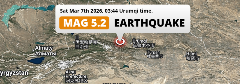
A shallow and significant Magnitude 5.2 earthquake struck under land 68 kilometer from Shihezi in China deep in the night of Saturday March 7th, 2026. The earthquake struck near a very densely populated region.
Felt the earthquake? Share this article: 


Earthquake Summary
The earthquake struck on land in China, 68 kilometer (42 mi) south-east of Shihezi in Xinjiang. The center of this earthquake had a very shallow depth of 10 km. Shallow earthquakes usually have a larger impact than earthquakes deep in the earth.
| Date and Time: | Mar 7, 2026 03:44 (Urumqi Time) - Mar 6, 2026 21:44 Universal Time. |
|---|---|
| Location: | 68 km SE of Shihezi, Xinjiang, China. Coordinates 43°45'40"N 86°25'18"E. |
| Map: | 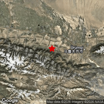 Map of area around epicenter. Click to open in Google Maps. |
| Magnitude: | MAG 5.2 Detected by 189 stations. Maximum Error Range ±0.042 . |
| Depth: | 10 km (6 mi) A very shallow depth. |
| Tsunami Risk: | Tsunami very unlikely While this was a shallow earthquake, it appears to have occurred under land with a magnitude not strong enough to cause tsunami's. Always stay cautious - More info here. |
Nearby towns and cities
This earthquake may have been felt in China . Shihezi in Xinjiang, China is the nearest significant place from the epicenter. The earthquake occurred 68 kilometer (42 mi) south-east of Shihezi.
Multiple major population centers exist within 300km of the earthquake that struck today. Ürümqi is located 95 km to the east. Shihezi is located 68 km to the northwest. Changji is located 76 km to the east.
The table below provides an overview of all places in proximity of today's earthquake.
Overview of nearby places
| Distance | Place |
|---|---|
| 68 km (42 mi) NW from epicenter |
Shihezi Xinjiang, China. |
| 76 km (47 mi) E from epicenter |
Changji Xinjiang, China. |
| 90 km (56 mi) NW from epicenter |
Sandaohezi Xinjiang, China. |
| 95 km (59 mi) E from epicenter |
Ürümqi Xinjiang, China. |
| 141 km (88 mi) NW from epicenter |
Dushanzi Xinjiang, China. |
| 158 km (98 mi) NW from epicenter |
Wusu Xinjiang, China. |
| 224 km (139 mi) S from epicenter |
Korla Xinjiang, China. |
| 236 km (147 mi) NW from epicenter |
Karamay Xinjiang, China. |
| 238 km (148 mi) NW from epicenter |
Baijiantan Xinjiang, China. |
| 241 km (150 mi) E from epicenter |
Turpan Xinjiang, China. |
| 258 km (160 mi) W from epicenter |
Xinyuan Xinjiang, China. |
Aftershocks detected
In the days before this main shock, 1 smaller foreshock was detected. A 5 magnitude earthquake hit 2 days earlier nearby.
Overview of foreshocks and aftershocks
| Classification | Magnitude | When | Where |
|---|---|---|---|
| Foreshock | M 5.0 |
2 days earlier Mar 5, 2026 06:15 (Urumqi Time) | 9 km (6 mi) S from Main Shock. |
| Main Shock This Earthquake |
M 5.2 |
Mar 7, 2026 03:44 (Urumqi Time) | - |
More earthquakes coming?
Earthquakes can create aftershocks. These are generally at least 1 magnitude lower than any main shock, and as time passes the chance and strength of aftershocks decreases.
The chance that a significant earthquake like this one is followed by an even larger earthquake is not so large. On average, scientists estimate a 94% chance that a major earthquake will not be followed by an even larger one. It is still adviced to be aware of this risk
Read: How to Stay Safe during an Earthquake (cdc.gov).This is the strongest earthquake in 6 years
Earthquakes of this strength occur quite regularly in the region. This is the strongest earthquake to hit since August 8th, 2020, when a 5.3 magnitude earthquake hit 116 km (72 mi) further south-east. An even stronger magnitude 6.3 earthquake struck on August 8th, 2017.
In total, 5 earthquakes with a magnitude of 5.2 or higher have been registered within 300km (186 mi) of this epicenter in the past 10 years. This comes down to an average of once every 2 years.
Tsunami very unlikely
While MAG-6.5+ earthquakes may cause tsunami's, it appears that the epicenter of this earthquake hit under land. In addition, the reported depth is deeper than 100km, making the risk of a tsunami even less likely. However always stay cautious and monitor advice from local authorities.
Tsunami Risk Factors
| Factor | Under Sea? | MAG-6.5 or stronger? | Shallow depth? |
|---|---|---|---|
| Explanation | Almost all tsunami's are caused by earthquakes with their epicenter under sea or very near the sea. However stay cautious in coastal areas as earthquakes on land may cause landslides into sea, potentially still causing a local tsunami. | Under MAG 6.5: Very unlikely to cause a tsunami. MAG 6.5 to 7.5: Destructive tsunami's do occur, but are uncommon. Likely to observe small sea level changes. MAG 7.6+: Earthquakes with these magnitudes might produce destructive tsunami's. |
Most destructive tsunami's are caused by shallow earthquakes with a depth between 0 and 100km under the surface of the earth. Deeper tsunami's are unlikely to displace to ocean floor. |
| This Earthquake | Not this earthquake. This earthquake appears to have struck on land far from any coast. |
Not this earthquake. This earthquake had a magnitude of 5.2. Earthquakes of this strength are unlikely to trigger a tsunami. |
This earthquake occurred at a depth of of 10 km (6 mi). Earthquakes this shallow could trigger a tsunami. |
Sources
Last updated 31/03/26 00:58 (). This article contains currently available information about the earthquake and is automatically composed. We continue to update this article up to a few days after the earthquake occurred.
- US Geographic Society (USGS): Earthquake us7000s2nf
- European-Mediterranean Seismological Centre (EMSC): Earthquake 20260306_0000357
- Geonames.org: World Cities Database
- Google Maps: Static API
- Earthquakelist.org: Historic Earthquakes Database
Share this article:
