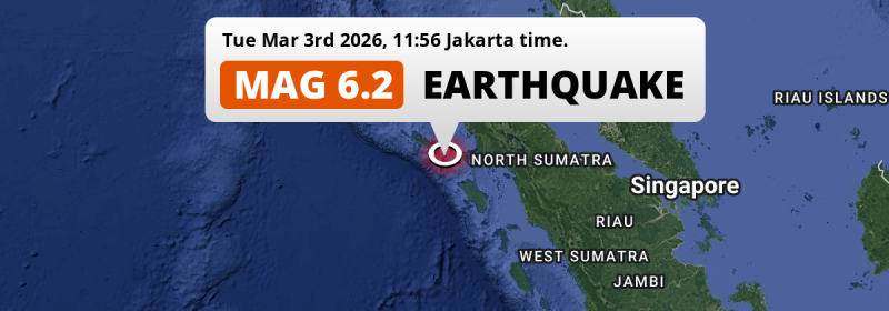
A shallow and strong MAG-6.2 earthquake struck in the Indian Ocean 280 kilometer from Medan, Indonesia around noon of Tuesday March 3rd, 2026. Around 3.4 million people have been exposed to shaking.
Felt the earthquake? Share this article: 


Earthquake Summary
This earthquake hit under water in the Indian Ocean, 46 kilometers (29 mi) off the coast of Indonesia, 280 kilometer southwest of Medan in North Sumatra. The center of this earthquake had a very shallow depth of 18 km. Shallow earthquakes usually have a larger impact than earthquakes deep in the earth.
| Date and Time: | Mar 3, 2026 11:56 (Jakarta Time) - Mar 3, 2026 04:56 Universal Time. |
|---|---|
| Location: | 280 km SW of Medan, North Sumatra, Indonesia. Coordinates 2°0'27"N 96°41'42"E. |
| Map: | 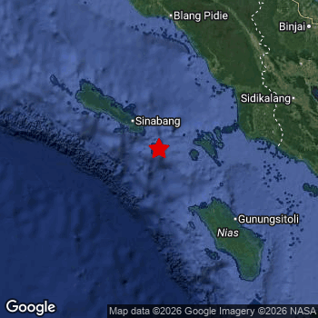 Map of area around epicenter. Click to open in Google Maps. |
| Magnitude: | MAG 6.2 Detected by 25 stations. Maximum Error Range ±0.062 . |
| Depth: | 18 km (11 mi) A very shallow depth. |
| Max. Intensity: | VII
Very Strong On the Modified Mercalli Scale. |
| Tsunami Risk: | Low tsunami risk Earthquakes under MAG-6.5 do not usually cause tsunami's. Always stay cautious - More info here. |
Minimal impact predicted
Based on scientific estimates by the US Geographic Survey (USGS), the risk of high fatalities for this earthquake is classified at level GREEN (low). They expect an 90% likelyhood of between 0 and 1 fatalities.
The USGS classifies the economic impact of this earthquake at level GREEN (low). They expect an 90% likelyhood of between 0 and 1 million US Dollars in economic damage and impact.
Roughly 3.4 million people exposed to shaking
This earthquake may have been felt by around 3.4 million people. That is the expected population size of the area exposed to a level of shaking of II or higher on the Modified Mercalli scale according to the USGS.
The highest earthquake impact level for this earthquake is VI, which corresponds with strong shaking and probably light damage. Roughly 690 people are expected to be exposed to this level. The majority of people (roughly 2.3 million) live in an area exposed to level III, where weak shaking and probably no damage is expected. All exposure to shaking was within the borders of Indonesia .
| People | MMI Level | Shaking | Damage |
|---|---|---|---|
| 0 | I |
Not noticable | None |
| 0 | II |
Very weak | None |
| 2,284,000 | III |
Weak | Probably none |
| 1,065,000 | IV |
Light | Likely none |
| 14,890 | V |
Moderate | Very light |
| 690 | VI |
Strong | Light |
| 0 | VII |
Very Strong | Moderate |
| 0 | VIII |
Severe | Moderate to heavy |
| 0 | IX |
Violent | Heavy |
| 0 | X |
Extreme | Very heavy |
Nearby towns and cities
This earthquake may have been felt in Indonesia . Singkil in Aceh, Indonesia is the nearest significant place from the epicenter. The earthquake occurred 125 kilometer (78 mi) west of Singkil. Singkil experienced an earthquake intensity (MMI Scale) of roughly IV. That level implies light shaking and likely no damage.
Multiple large cities are in proximity of today's earthquake. Medan is located 280 km to the north-east (intensity unknown, possibly low). Percut is located 301 km to the north-east (intensity unknown, possibly low). Binjai is located 266 km to the north-east and experienced an intensity of III (weak shaking, probably no damage).
The table below provides an overview of all places in proximity of today's earthquake. Where available, the estimated intensity on the Modified Mercalli Intensity Scale in each place is included. Places where this information is omitted likely experienced little impact.
Overview of nearby places
| Distance | Place | Intensity (MMI) |
|---|---|---|
| 125 km (78 mi) E from epicenter |
Singkil Aceh, Indonesia. |
IV
Light |
| 226 km (140 mi) NE from epicenter |
Tongging North Sumatra, Indonesia. |
|
| 234 km (145 mi) E from epicenter |
Sibolga North Sumatra, Indonesia. |
|
| 234 km (145 mi) NE from epicenter |
Kabanjahe North Sumatra, Indonesia. |
III
Weak |
| 241 km (150 mi) NE from epicenter |
Berastagi North Sumatra, Indonesia. |
|
| 246 km (153 mi) N from epicenter |
Meulaboh Aceh, Indonesia. |
|
| 266 km (165 mi) NE from epicenter |
Binjai North Sumatra, Indonesia. |
III
Weak |
| 274 km (170 mi) NE from epicenter |
Stabat North Sumatra, Indonesia. |
III
Weak |
| 276 km (171 mi) NE from epicenter |
Sunggal North Sumatra, Indonesia. |
|
| 277 km (172 mi) NE from epicenter |
Deli Tua North Sumatra, Indonesia. |
|
| 280 km (174 mi) NE from epicenter |
Medan North Sumatra, Indonesia. |
|
| 284 km (176 mi) E from epicenter |
Pematangsiantar North Sumatra, Indonesia. |
|
| 285 km (177 mi) NE from epicenter |
Pangkalan Brandan North Sumatra, Indonesia. |
|
| 291 km (181 mi) NE from epicenter |
Labuhan Deli North Sumatra, Indonesia. |
|
| 295 km (183 mi) NE from epicenter |
Tanjungtiram North Sumatra, Indonesia. |
|
| 295 km (183 mi) E from epicenter |
Padangsidempuan North Sumatra, Indonesia. |
|
| 296 km (184 mi) NE from epicenter |
Belawan North Sumatra, Indonesia. |
|
| 301 km (187 mi) NE from epicenter |
Percut North Sumatra, Indonesia. |
|
| 302 km (188 mi) NE from epicenter |
Pekan Bahapal North Sumatra, Indonesia. |
|
| 305 km (190 mi) NE from epicenter |
Perbaungan North Sumatra, Indonesia. |
|
| 308 km (191 mi) NE from epicenter |
Langsa Aceh, Indonesia. |
|
| 311 km (193 mi) NE from epicenter |
Tebingtinggi North Sumatra, Indonesia. |
|
| 340 km (211 mi) E from epicenter |
Bandar North Sumatra, Indonesia. |
|
| 342 km (213 mi) E from epicenter |
Kisaran North Sumatra, Indonesia. |
|
| 349 km (217 mi) E from epicenter |
Rantauprapat North Sumatra, Indonesia. |
|
| 355 km (221 mi) N from epicenter |
Bireun Aceh, Indonesia. |
|
| 356 km (221 mi) N from epicenter |
Lhokseumawe Aceh, Indonesia. |
|
| 360 km (224 mi) N from epicenter |
Reuleuet Aceh, Indonesia. |
|
| 361 km (224 mi) E from epicenter |
Tanjungbalai North Sumatra, Indonesia. |
|
| 364 km (226 mi) E from epicenter |
Teluk Nibung North Sumatra, Indonesia. |
|
| 384 km (239 mi) N from epicenter |
Sigli Aceh, Indonesia. |
Earthquake Intensity Map
The graph below overlays a map of the region around the epicenter with earthquake intensity data provided by the US Geographic Survey. The highest intensity level detected for this earthquake is VI.

Shaking reported by 1 person
People that feel an earthquake may report their experience to the US Geographic Survey. Currently, 1 person has reported shaking in one place in Indonesia.We keep updating this article as more ground reports become available. You may report that you felt this earthquake here.
Places with most reports:
- Kabanjahe, Sumatera Utara, Indonesia: 1 person.
9 Aftershocks detected
After this earthquake struck, 9 smaller aftershocks occurred. Just 1 hr after this main shock, an earthquake measuring MAG-4.4 was detected 56 km (35 mi) north-east of this earthquake.
Overview of foreshocks and aftershocks
| Classification | Magnitude | When | Where |
|---|---|---|---|
| Main Shock This Earthquake |
M 6.2 |
Mar 3, 2026 11:56 (Jakarta Time) | - |
| Aftershock | M 3.3 |
18 mins later Mar 3, 2026 12:14 (Jakarta Time) | 35 km (21 mi) N from Main Shock. |
| Aftershock | M 3.6 |
1 hr later Mar 3, 2026 12:59 (Jakarta Time) | 21 km (13 mi) W from Main Shock. |
| Aftershock | M 4.4 |
1 hr later Mar 3, 2026 12:59 (Jakarta Time) | 56 km (35 mi) NE from Main Shock. |
| Aftershock | M 2.5 |
1 hr later Mar 3, 2026 13:06 (Jakarta Time) | 23 km (14 mi) N from Main Shock. |
| Aftershock | M 2.9 |
3 hrs later Mar 3, 2026 15:13 (Jakarta Time) | 28 km (18 mi) W from Main Shock. |
| Aftershock | M 3.0 |
6 hrs later Mar 3, 2026 17:52 (Jakarta Time) | 11 km (7 mi) N from Main Shock. |
| Aftershock | M 2.7 |
7 hrs later Mar 3, 2026 19:23 (Jakarta Time) | 24 km (15 mi) S from Main Shock. |
| Aftershock | M 3.1 |
11 hrs later Mar 3, 2026 22:32 (Jakarta Time) | 34 km (21 mi) SW from Main Shock. |
| Aftershock | M 2.7 |
23 hrs later Mar 4, 2026 11:15 (Jakarta Time) | 45 km (28 mi) NW from Main Shock. |
More earthquakes coming?
The risk of aftershocks decreases rapidly over time. Usually, aftershocks are at least one order of magnitude lower than a main shock.
In only six percent of cases, significant earthquakes are followed by a larger main shock, making the current earthquake a foreshock. While the chance of this happening is not so large, it is adviced to maintain cautiousness in the hours and days following a major earthquake.
Read: How to Stay Safe during an Earthquake (cdc.gov).Earthquakes like this are common in the region
Earthquakes of this strength occur quite regularly in the region. This is the strongest earthquake to hit since November 27th, 2025, when a 6.4 magnitude earthquake hit 114 km (71 mi) further northwest. An even stronger magnitude 6.7 earthquake struck on May 14th, 2021.
In total, 3 earthquakes with a magnitude of 6.2 or higher have been registered within 300km (186 mi) of this epicenter in the past 10 years. This comes down to an average of once every 3 years.
Low tsunami risk
Based on early data it appears this earthquake was not strong enough (lower than MAG-6.5) to be likely to cause destructive tsunami's. However this earthquake appeared to have hit at a shallow depth under sea, so stay cautious and monitor advice from local authorities.
Tsunami Risk Factors
| Factor | Under Sea? | MAG-6.5 or stronger? | Shallow depth? |
|---|---|---|---|
| Explanation | Almost all tsunami's are caused by earthquakes with their epicenter under sea or very near the sea. However stay cautious in coastal areas as earthquakes on land may cause landslides into sea, potentially still causing a local tsunami. | Under MAG 6.5: Very unlikely to cause a tsunami. MAG 6.5 to 7.5: Destructive tsunami's do occur, but are uncommon. Likely to observe small sea level changes. MAG 7.6+: Earthquakes with these magnitudes might produce destructive tsunami's. |
Most destructive tsunami's are caused by shallow earthquakes with a depth between 0 and 100km under the surface of the earth. Deeper tsunami's are unlikely to displace to ocean floor. |
| This Earthquake | This earthquake appears to have struck under the sea. | Not this earthquake. This earthquake had a magnitude of 6.2. Earthquakes of this strength are unlikely to trigger a tsunami. |
This earthquake occurred at a depth of of 18 km (11 mi). Earthquakes this shallow could trigger a tsunami. |
Sources
Last updated 01/05/26 12:48 (). As more information on this earthquake becomes available this article will be updated. This article is automatically composed based on data originating from multiple sources.
- US Geographic Society (USGS): Earthquake us7000s1ln
- European-Mediterranean Seismological Centre (EMSC): Earthquake 20260303_0000055
- Geonames.org: World Cities Database
- Google Maps: Static API
- Earthquakelist.org: Historic Earthquakes Database
Share this article:
