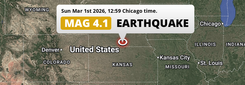
In the early afternoon of Sunday March 1st, 2026, a shallow Magnitude 4.1 earthquake hit under land 30 miles from Hastings in The United States. Roughly 2.1 million people may have felt this earthquake.
Felt the earthquake? Share this article: 


Earthquake Summary
The earthquake struck on land in The United States, 30 miles (48 km) south of Hastings in Nebraska. The center of this earthquake had a very shallow depth of 3 km. Shallow earthquakes usually have a larger impact than earthquakes deep in the earth.
| Date and Time: | Mar 1, 2026 12:59PM (Chicago Time) - Mar 1, 2026 18:59 Universal Time. |
|---|---|
| Location: | 30 mi south of Hastings, Nebraska, The United States. Coordinates 40°9'28"N 98°23'15"W. |
| Map: | 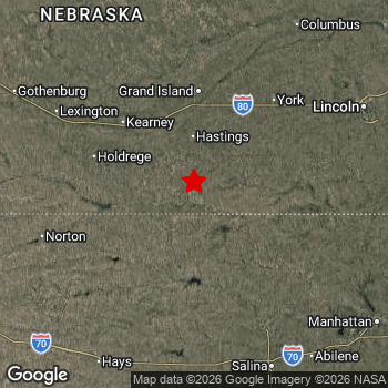 Map of area around epicenter. Click to open in Google Maps. |
| Magnitude: | MAG 4.1 Detected by 29 stations. Maximum Error Range ±0.058 . |
| Depth: | 3 mi (5 km) A very shallow depth. |
| Max. Intensity: | V
Moderate On the Modified Mercalli Scale. |
| Tsunami Risk: | Tsunami very unlikely While this was a shallow earthquake, it appears to have occurred under land with a magnitude not strong enough to cause tsunami's. Always stay cautious - More info here. |
Minimal impact predicted
Based on scientific estimates by the US Geographic Survey (USGS), the risk of high fatalities for this earthquake is classified at level GREEN (low). They expect an 69% likelyhood of between 0 and 1 fatalities, and a 98% chance that the number of fatalities falls no higher than 10.
The USGS classifies the economic impact of this earthquake at level GREEN (low). They expect an 65% likelyhood of between 0 and 1 million US Dollars in economic damage and impact, and a 96% chance that the economic impact of this earthquake falls no higher than 10 million USD.
Roughly 2.1 million people exposed to shaking
The USGS has published a report estimating the number of people exposed to this earthquake. Acoording to their analysis, roughly 2.1 million have been exposed to shaking at an MMI level of II or higher.
Moderate shaking and very light damage may have been experienced by an estimated 90 people. At V, it is the highest MMI level this earthquake has caused. The majority of people (roughly 2 million) live in an area exposed to level III, where weak shaking and probably no damage is expected.
| People | MMI Level | Shaking | Damage |
|---|---|---|---|
| 0 | I |
Not noticable | None |
| 60,740 | II |
Very weak | None |
| 2,022,000 | III |
Weak | Probably none |
| 9,980 | IV |
Light | Likely none |
| 90 | V |
Moderate | Very light |
| 0 | VI |
Strong | Light |
| 0 | VII |
Very Strong | Moderate |
| 0 | VIII |
Severe | Moderate to heavy |
| 0 | IX |
Violent | Heavy |
| 0 | X |
Extreme | Very heavy |
Nearby towns and cities
This earthquake may have been felt in The United States . Located 30 miles (48 km) south of the epicenter of this earthquake, Hastings (Nebraska, The United States) is the nearest significant population center. The intensity of shaking and damage in Hastings is estimated to be around level III on the Modified Mercalli Intensity scale (weak shaking, probably no damage).
Multiple major population centers exist within 300km of the earthquake that struck today. Omaha is located 149 mi to the north-east (intensity unknown, possibly low). Lincoln is located 101 mi to the north-east and experienced an intensity of III (weak shaking, probably no damage). Wichita is located 180 mi to the south (intensity unknown, possibly low).
An overview of nearby towns and cities is available in the overview below. If places don't have intensity data available, it likely means the experienced impact in those places was fairly small.
Overview of nearby places
| Distance | Place | Intensity (MMI) |
|---|---|---|
| 30 mi (48 km) N from epicenter |
Hastings Nebraska, The United States. |
III
Weak |
| 52 mi (84 km) NW from epicenter |
Kearney Nebraska, The United States. |
III
Weak |
| 53 mi (85 km) N from epicenter |
Grand Island Nebraska, The United States. |
III
Weak |
| 100 mi (161 km) SE from epicenter |
Salina Kansas, The United States. |
III
Weak |
| 101 mi (162 km) NE from epicenter |
Lincoln Nebraska, The United States. |
III
Weak |
| 101 mi (163 km) SW from epicenter |
Hays Kansas, The United States. |
III
Weak |
| 103 mi (165 km) NE from epicenter |
Columbus Nebraska, The United States. |
III
Weak |
| 114 mi (183 km) SE from epicenter |
Junction City Kansas, The United States. |
III
Weak |
| 117 mi (189 km) SE from epicenter |
Manhattan Kansas, The United States. |
III
Weak |
| 126 mi (202 km) S from epicenter |
Great Bend Kansas, The United States. |
III
Weak |
| 132 mi (213 km) NE from epicenter |
Fremont Nebraska, The United States. |
III
Weak |
| 139 mi (223 km) N from epicenter |
Norfolk Nebraska, The United States. |
|
| 141 mi (227 km) NE from epicenter |
Papillion Nebraska, The United States. |
III
Weak |
| 142 mi (228 km) NW from epicenter |
North Platte Nebraska, The United States. |
|
| 142 mi (229 km) NE from epicenter |
La Vista Nebraska, The United States. |
III
Weak |
| 147 mi (236 km) S from epicenter |
Hutchinson Kansas, The United States. |
|
| 147 mi (237 km) NE from epicenter |
Bellevue Nebraska, The United States. |
|
| 149 mi (240 km) NE from epicenter |
Omaha Nebraska, The United States. |
|
| 153 mi (246 km) NE from epicenter |
Council Bluffs Iowa, The United States. |
|
| 156 mi (251 km) S from epicenter |
Newton Kansas, The United States. |
|
| 163 mi (263 km) SE from epicenter |
Topeka Kansas, The United States. |
|
| 169 mi (272 km) SE from epicenter |
Emporia Kansas, The United States. |
II
Weak |
| 180 mi (289 km) S from epicenter |
Wichita Kansas, The United States. |
Earthquake Intensity Map
The graph below overlays a map of the region around the epicenter with earthquake intensity data provided by the US Geographic Survey. The highest intensity level detected for this earthquake is V.

2 Aftershocks detected
After this earthquake struck, 2 smaller aftershocks occurred. At a distance of 3 mi (5 km) east of this earthquake, an aftershock struck 8 hrs later. It measured a magnitude of 2.6
Overview of foreshocks and aftershocks
| Classification | Magnitude | When | Where |
|---|---|---|---|
| Main Shock This Earthquake |
M 4.1 |
Mar 1, 2026 12:59PM (Chicago Time) | - |
| Aftershock | M 2.6 |
1 hr later Mar 1, 2026 02:26PM (Chicago Time) | 2.2 mi (4 km) E from Main Shock. |
| Aftershock | M 2.6 |
8 hrs later Mar 1, 2026 08:45PM (Chicago Time) | 3 mi (5 km) E from Main Shock. |
More earthquakes coming?
Earthquakes can create aftershocks. These are generally at least 1 magnitude lower than any main shock, and as time passes the chance and strength of aftershocks decreases.
The chance that a significant earthquake like this one is followed by an even larger earthquake is not so large. On average, scientists estimate a 94% chance that a major earthquake will not be followed by an even larger one. It is still adviced to be aware of this risk
Read: How to Stay Safe during an Earthquake (cdc.gov).This is the strongest earthquake in 4 years
Earthquakes of this strength occur quite regularly in the region. This is the strongest earthquake to hit since December 8th, 2021, when a 4.3 magnitude earthquake hit 115 mi (186 km) further south-east. An even stronger magnitude 4.6 earthquake struck on June 22nd, 2019.
In total, 4 earthquakes with a magnitude of 4.1 or higher have been registered within 300km (186 mi) of this epicenter in the past 10 years. This comes down to an average of once every 3 years.
Tsunami very unlikely
While MAG-6.5+ earthquakes may cause tsunami's, it appears that the epicenter of this earthquake hit under land. In addition, the reported depth is deeper than 100km, making the risk of a tsunami even less likely. However always stay cautious and monitor advice from local authorities.
Tsunami Risk Factors
| Factor | Under Sea? | MAG-6.5 or stronger? | Shallow depth? |
|---|---|---|---|
| Explanation | Almost all tsunami's are caused by earthquakes with their epicenter under sea or very near the sea. However stay cautious in coastal areas as earthquakes on land may cause landslides into sea, potentially still causing a local tsunami. | Under MAG 6.5: Very unlikely to cause a tsunami. MAG 6.5 to 7.5: Destructive tsunami's do occur, but are uncommon. Likely to observe small sea level changes. MAG 7.6+: Earthquakes with these magnitudes might produce destructive tsunami's. |
Most destructive tsunami's are caused by shallow earthquakes with a depth between 0 and 100km under the surface of the earth. Deeper tsunami's are unlikely to displace to ocean floor. |
| This Earthquake | Not this earthquake. This earthquake appears to have struck on land far from any coast. |
Not this earthquake. This earthquake had a magnitude of 4.1. Earthquakes of this strength are unlikely to trigger a tsunami. |
This earthquake occurred at a depth of of 3 mi (5 km). Earthquakes this shallow could trigger a tsunami. |
Sources
Last updated 31/03/26 00:48 (). As more information on this earthquake becomes available this article will be updated. This article is automatically composed based on data originating from multiple sources.
- US Geographic Society (USGS): Earthquake us7000s1a2
- European-Mediterranean Seismological Centre (EMSC): Earthquake 20260301_0000305
- Geonames.org: World Cities Database
- Google Maps: Static API
- Earthquakelist.org: Historic Earthquakes Database
Share this article:
