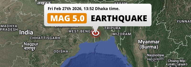
Under land 50 kilometer from Khulna in Bangladesh, a shallow and significant MAG-5.0 earthquake occurred in the early afternoon of Friday February 27th, 2026. The earthquake struck near a very densely populated region. Earthquakes like this can cause significant economic damage and have a significant risk at casualties. Another country near the epicenter is India.
Felt the earthquake? Share this article: 


Earthquake Summary
The earthquake struck on land in Bangladesh, 50 kilometer (31 mi) southwest of Khulna. The center of this earthquake had a very shallow depth of 10 km. Shallow earthquakes usually have a larger impact than earthquakes deep in the earth.
| Date and Time: | Feb 27, 2026 01:52PM (Dhaka Time) - Feb 27, 2026 07:52 Universal Time. |
|---|---|
| Location: | 50 km SW of Khulna, Bangladesh. Coordinates 22°31'25"N 89°11'7"E. |
| Map: | 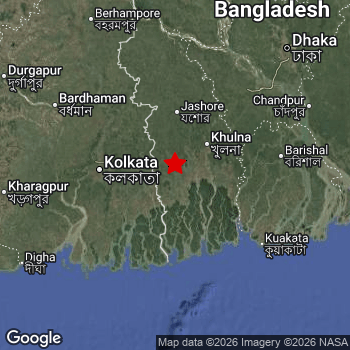 Map of area around epicenter. Click to open in Google Maps. |
| Magnitude: | MAG 5.0 Detected by 11 stations. Maximum Error Range ±0.093 . |
| Depth: | 10 km (6 mi) A very shallow depth. |
| Max. Intensity: | VII
Very Strong On the Modified Mercalli Scale. |
| Tsunami Risk: | Tsunami very unlikely While this was a shallow earthquake, it appears to have occurred under land with a magnitude not strong enough to cause tsunami's. Always stay cautious - More info here. |
Significant impact predicted
The US Geographic Survey (USGS) describes the impact of this earthquake as follows:
Three persons injured, many homes and several buildings damaged in Satkhira, Bangladesh. Some buildings and a road damaged in Kolkata.
Based on scientific estimates by the USGS, the risk of high fatalities for this earthquake is classified at level YELLOW (significant). They expect an 35% likelyhood of between 10 and 100 fatalities, and a 93% chance that the number of fatalities falls no higher than 1,000.
The USGS classifies the economic impact of this earthquake at level YELLOW (significant). They expect an 35% likelyhood of between 10 and 100 million US Dollars in economic damage and impact, and a 93% chance that the economic impact of this earthquake falls no higher than 1,000 million USD.
Roughly 157 million people exposed to shaking
An estimated 157 million have been exposed to shaking (An MMI or Modified Mercalli Intensity level II or higher) as a result of this earthquake according scientific estimates published by the USGS.
The highest earthquake impact level for this earthquake is VII, which corresponds with very strong shaking and likely moderate damage. Roughly 106,000 people are expected to be exposed to this level. Intensity level IV was experienced by the majority of people (around 146 million). In their region, light shaking and likely no damage can be expected.
People in 2 countries have been exposed to shaking. In Bangladesh , around 83 million people, with impact levels up to VII (very strong shaking, likely moderate damage). In India , around 74 million people.
| People | MMI Level | Shaking | Damage |
|---|---|---|---|
| 0 | I |
Not noticable | None |
| 0 | II |
Very weak | None |
| 0 | III |
Weak | Probably none |
| 145,600,000 | IV |
Light | Likely none |
| 10,440,000 | V |
Moderate | Very light |
| 1,099,000 | VI |
Strong | Light |
| 106,000 | VII |
Very Strong | Moderate |
| 0 | VIII |
Severe | Moderate to heavy |
| 0 | IX |
Violent | Heavy |
| 0 | X |
Extreme | Very heavy |
Nearby towns and cities
2 countries can be found within 300km of the epicenter of this earthquake: Bangladesh and India .
The closest significant population center near the earthquake is Sātkhira in Khulna, Bangladesh. Sātkhira is located 24 kilometer (15 mi) south-east of the epicenter. The intensity of shaking and damage in Sātkhira is estimated to be around level V on the Modified Mercalli Intensity scale (moderate shaking, very light damage).
Multiple large cities are in proximity of today's earthquake. Dhaka is located 182 km to the north-east and experienced an intensity of IV (light shaking, likely no damage). Kolkata is located 85 km to the west and experienced an intensity of IV (light shaking, likely no damage). Khulna is located 50 km to the north-east and experienced an intensity of V (moderate shaking, very light damage).
An overview of nearby towns and cities is available in the overview below. If places don't have intensity data available, it likely means the experienced impact in those places was fairly small.
Overview of nearby places
| Distance | Place | Intensity (MMI) |
|---|---|---|
| 24 km (15 mi) NW from epicenter |
Sātkhira Khulna, Bangladesh. |
V
Moderate |
| 27 km (17 mi) W from epicenter |
Tāki West Bengal, India. |
V
Moderate |
| 40 km (25 mi) NE from epicenter |
Phultala Khulna, Bangladesh. |
V
Moderate |
| 43 km (27 mi) N from epicenter |
Kesabpur Khulna, Bangladesh. |
V
Moderate |
| 48 km (30 mi) NW from epicenter |
Badūria West Bengal, India. |
V
Moderate |
| 50 km (31 mi) NE from epicenter |
Khulna Khulna, Bangladesh. |
V
Moderate |
| 56 km (35 mi) SW from epicenter |
Gosāba West Bengal, India. |
V
Moderate |
| 58 km (36 mi) SW from epicenter |
Canning West Bengal, India. |
V
Moderate |
| 59 km (37 mi) NW from epicenter |
Gobārdānga West Bengal, India. |
V
Moderate |
| 61 km (38 mi) NE from epicenter |
Bhātpāra Abhaynagar Khulna, Bangladesh. |
IV
Light |
| 64 km (40 mi) E from epicenter |
Bagerhat Khulna, Bangladesh. |
IV
Light |
| 65 km (40 mi) NW from epicenter |
Hābra West Bengal, India. |
IV
Light |
| 66 km (41 mi) N from epicenter |
Jhingergācha Khulna, Bangladesh. |
IV
Light |
| 67 km (42 mi) E from epicenter |
Sarankhola Khulna, Bangladesh. |
IV
Light |
| 68 km (42 mi) NW from epicenter |
Bangaon West Bengal, India. |
IV
Light |
| 68 km (42 mi) NW from epicenter |
Ashoknagar Kalyangarh West Bengal, India. |
IV
Light |
| 72 km (45 mi) N from epicenter |
Jessore Khulna, Bangladesh. |
IV
Light |
| 75 km (47 mi) W from epicenter |
Bārāsat West Bengal, India. |
IV
Light |
| 77 km (48 mi) NE from epicenter |
Narail Khulna, Bangladesh. |
IV
Light |
| 78 km (48 mi) W from epicenter |
Madhyamgram West Bengal, India. |
IV
Light |
| 78 km (48 mi) W from epicenter |
Rajpur Sonarpur West Bengal, India. |
IV
Light |
| 79 km (49 mi) W from epicenter |
Dam Dam West Bengal, India. |
IV
Light |
| 79 km (49 mi) W from epicenter |
Baruipur West Bengal, India. |
IV
Light |
| 81 km (50 mi) E from epicenter |
Pirojpur Barisāl, Bangladesh. |
IV
Light |
| 84 km (52 mi) W from epicenter |
Baranagar West Bengal, India. |
IV
Light |
| 85 km (53 mi) W from epicenter |
Kāmārhāti West Bengal, India. |
IV
Light |
| 85 km (53 mi) NE from epicenter |
Tungipāra Dhaka, Bangladesh. |
IV
Light |
| 85 km (53 mi) W from epicenter |
Pānihāti West Bengal, India. |
IV
Light |
| 85 km (53 mi) W from epicenter |
Kolkata West Bengal, India. |
IV
Light |
| 86 km (53 mi) W from epicenter |
Khardah West Bengal, India. |
IV
Light |
| 87 km (54 mi) W from epicenter |
Titāgarh West Bengal, India. |
IV
Light |
| 88 km (55 mi) W from epicenter |
Bāli West Bengal, India. |
IV
Light |
| 89 km (55 mi) W from epicenter |
Konnagar West Bengal, India. |
IV
Light |
| 89 km (55 mi) W from epicenter |
Bārākpur West Bengal, India. |
IV
Light |
| 89 km (55 mi) W from epicenter |
Rishra West Bengal, India. |
IV
Light |
| 89 km (55 mi) W from epicenter |
Hāora West Bengal, India. |
IV
Light |
| 89 km (55 mi) NW from epicenter |
Naihāti West Bengal, India. |
IV
Light |
| 89 km (55 mi) NW from epicenter |
Bhātpāra West Bengal, India. |
IV
Light |
| 90 km (56 mi) W from epicenter |
Shrīrāmpur West Bengal, India. |
IV
Light |
| 91 km (57 mi) NW from epicenter |
Hālīsahar West Bengal, India. |
IV
Light |
| 91 km (57 mi) W from epicenter |
Shyamnagar West Bengal, India. |
IV
Light |
| 92 km (57 mi) NW from epicenter |
Kānchrāpāra West Bengal, India. |
IV
Light |
| 92 km (57 mi) NW from epicenter |
Hugli West Bengal, India. |
IV
Light |
| 92 km (57 mi) NW from epicenter |
Kalyani West Bengal, India. |
IV
Light |
| 92 km (57 mi) NW from epicenter |
Chandannagar West Bengal, India. |
IV
Light |
| 93 km (58 mi) W from epicenter |
Baidyabāti West Bengal, India. |
IV
Light |
| 93 km (58 mi) W from epicenter |
Bhadreswar West Bengal, India. |
IV
Light |
| 94 km (58 mi) NW from epicenter |
Bānsbāria West Bengal, India. |
IV
Light |
| 96 km (60 mi) W from epicenter |
Maheshtala West Bengal, India. |
IV
Light |
| 96 km (60 mi) NW from epicenter |
Rānāghāt West Bengal, India. |
IV
Light |
| 165 km (103 mi) N from epicenter |
Pābna Rajshahi Division, Bangladesh. |
IV
Light |
| 182 km (113 mi) NE from epicenter |
Dhaka Dhaka, Bangladesh. |
IV
Light |
| 259 km (161 mi) NE from epicenter |
Agartala Tripura, India. |
|
| 259 km (161 mi) SW from epicenter |
Balasore Odisha, India. |
|
| 273 km (170 mi) E from epicenter |
Chattogram Chittagong, Bangladesh. |
|
| 277 km (172 mi) NW from epicenter |
Dumka Jharkhand, India. |
|
| 278 km (173 mi) NE from epicenter |
Mymensingh Mymensingh Division, Bangladesh. |
Earthquake Intensity Map
The graph below overlays a map of the region around the epicenter with earthquake intensity data provided by the US Geographic Survey. The highest intensity level detected for this earthquake is VII.

Shaking reported by 221 people in 2 countries
People that feel an earthquake may report their experience to the US Geographic Survey. Currently, 221 people have reported shaking in 59 places in 2 countries (India, Bangladesh).We keep updating this article as more ground reports become available. You may report that you felt this earthquake here.
Places with most reports:
- Dacca, Dhāka, Bangladesh: 29 people.
- Calcutta, Bangla, India: 26 people.
- Ţungī, Gazipur, Bangladesh: 22 people.
- Chakdaha, Bangla, India: 22 people.
- Bidhannagar, Bangla, India: 19 people.
- Khulna, Khulnā, Bangladesh: 8 people.
- Dum Dum, Bangla, India: 6 people.
- Barabazar, Bangla, India: 5 people.
- North Dum Dum, Bangla, India: 4 people.
- Kharagpur, Bangla, India: 4 people.
Risk of aftershocks?
We monitor for foreshocks or aftershocks that have a magnitude of 2.5+ and occur within 100km (62 mi) of the epicenter of this earthquake. So far no such earthquakes have been detected.
The risk of aftershocks decreases rapidly over time. Usually, aftershocks are at least one order of magnitude lower than a main shock.
In only six percent of cases, significant earthquakes are followed by a larger main shock, making the current earthquake a foreshock. While the chance of this happening is not so large, it is adviced to maintain cautiousness in the hours and days following a major earthquake.
Read: How to Stay Safe during an Earthquake (cdc.gov).This is an unusually powerful earthquake
Earthquakes of this strength are not so common in the region, but it's not the first time. This is the strongest earthquake to hit since November 21st, 2025, when a 5.4 magnitude earthquake hit 203 km (126 mi) further north-east. An even stronger magnitude 5.5 earthquake struck on December 2nd, 2023.
In total, 2 earthquakes with a magnitude of 5 or higher have been registered within 300km (186 mi) of this epicenter in the past 10 years. This comes down to an average of once every 5 years.
Tsunami very unlikely
While MAG-6.5+ earthquakes may cause tsunami's, it appears that the epicenter of this earthquake hit under land. In addition, the reported depth is deeper than 100km, making the risk of a tsunami even less likely. However always stay cautious and monitor advice from local authorities.
Tsunami Risk Factors
| Factor | Under Sea? | MAG-6.5 or stronger? | Shallow depth? |
|---|---|---|---|
| Explanation | Almost all tsunami's are caused by earthquakes with their epicenter under sea or very near the sea. However stay cautious in coastal areas as earthquakes on land may cause landslides into sea, potentially still causing a local tsunami. | Under MAG 6.5: Very unlikely to cause a tsunami. MAG 6.5 to 7.5: Destructive tsunami's do occur, but are uncommon. Likely to observe small sea level changes. MAG 7.6+: Earthquakes with these magnitudes might produce destructive tsunami's. |
Most destructive tsunami's are caused by shallow earthquakes with a depth between 0 and 100km under the surface of the earth. Deeper tsunami's are unlikely to displace to ocean floor. |
| This Earthquake | Not this earthquake. This earthquake appears to have struck on land far from any coast. |
Not this earthquake. This earthquake had a magnitude of 5. Earthquakes of this strength are unlikely to trigger a tsunami. |
This earthquake occurred at a depth of of 10 km (6 mi). Earthquakes this shallow could trigger a tsunami. |
Sources
Last updated 01/04/26 02:18 (). As more information on this earthquake becomes available this article will be updated. This article is automatically composed based on data originating from multiple sources.
- US Geographic Society (USGS): Earthquake us7000s0pc
- European-Mediterranean Seismological Centre (EMSC): Earthquake 20260227_0000104
- Geonames.org: World Cities Database
- Google Maps: Static API
- Earthquakelist.org: Historic Earthquakes Database
Share this article:
