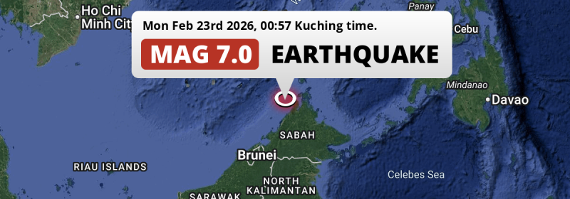
In the night of Monday February 23rd, 2026, an unusually powerful M7.0 earthquake hit in the South China Sea 96 kilometer from Kota Kinabalu, Malaysia. The USGS has indicated there is a potential risk at tsunami's following this earthquake. Brunei, The Philippines and Indonesia are also near its epicenter.
Felt the earthquake? Share this article: 


Earthquake Summary
This earthquake hit under water in the South China Sea, 41 kilometers (26 mi) off the coast of Malaysia, 96 kilometer north of Kota Kinabalu in Sabah. The center of this earthquake had a very deep depth of 629 km. Deep earthquakes usually have less impact than shallower earthquakes of similar strenght.
| Date and Time: | Feb 23, 2026 12:57AM (Kuching Time) - Feb 22, 2026 16:57 Universal Time. |
|---|---|
| Location: | 96 km north of Kota Kinabalu, Sabah, Malaysia. Coordinates 6°49'12"N 116°15'13"E. |
| Map: | 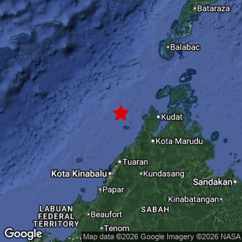 Map of area around epicenter. Click to open in Google Maps. |
| Magnitude: | MAG 7.0 Detected by 9 stations. Maximum Error Range ±0.05 . |
| Depth: | 629 km (391 mi) A very deep depth. |
| Max. Intensity: | V
Moderate On the Modified Mercalli Scale. |
| Tsunami Risk: | Potential tsunami risk The USGS has indicated there is a potential risk at tsunami's following this earthquake. Always stay cautious - More info here. |
Potential tsunami risk
There is a potential tsunami risk in the aftermath of this earthquake, immediately evacuate to higher grounds away from coastal areas and monitor advice from local authorities. The US Geographic Survey organization has indicated a potential risk for tsunami's following this earthquake.
Tsunami Risk Factors
| Factor | Under Sea? | MAG-6.5 or stronger? | Shallow depth? |
|---|---|---|---|
| Explanation | Almost all tsunami's are caused by earthquakes with their epicenter under sea or very near the sea. However stay cautious in coastal areas as earthquakes on land may cause landslides into sea, potentially still causing a local tsunami. | Under MAG 6.5: Very unlikely to cause a tsunami. MAG 6.5 to 7.5: Destructive tsunami's do occur, but are uncommon. Likely to observe small sea level changes. MAG 7.6+: Earthquakes with these magnitudes might produce destructive tsunami's. |
Most destructive tsunami's are caused by shallow earthquakes with a depth between 0 and 100km under the surface of the earth. Deeper tsunami's are unlikely to displace to ocean floor. |
| This Earthquake | This earthquake appears to have struck under the sea. | This earthquake had a magnitude of 7. Earthquakes of this strength could trigger a tsunami. | Not this earthquake. This earthquake occurred at a depth of 629 km (391 mi). Earthquakes this deep in the earth are unlikely to trigger a tsunami. |
Minimal impact predicted
Based on scientific estimates by the US Geographic Survey (USGS), the risk of high fatalities for this earthquake is classified at level GREEN (low). They expect an 65% likelyhood of between 0 and 1 fatalities, and a 96% chance that the number of fatalities falls no higher than 10.
The USGS classifies the economic impact of this earthquake at level GREEN (low). They expect an 59% likelyhood of between 0 and 1 million US Dollars in economic damage and impact, and a 94% chance that the economic impact of this earthquake falls no higher than 10 million USD.
Roughly 84 million people exposed to shaking
This earthquake may have been felt by around 84 million people. That is the expected population size of the area exposed to a level of shaking of II or higher on the Modified Mercalli scale according to the USGS.
The highest earthquake impact level for this earthquake is V, which corresponds with moderate shaking and very light damage. Roughly 5,594,000 people are expected to be exposed to this level. Intensity level IV was experienced by the majority of people (around 78 million). In their region, light shaking and likely no damage can be expected.
People in 5 countries have been exposed to shaking. In The Philippines , around 59 million people, with impact levels up to V (moderate shaking, very light damage). In Indonesia , around 13 million people. In Malaysia , around 6.5 million people. Other countries where people were exposed to shaking include Brunei and Vietnam.
| People | MMI Level | Shaking | Damage |
|---|---|---|---|
| 0 | I |
Not noticable | None |
| 0 | II |
Very weak | None |
| 330,000 | III |
Weak | Probably none |
| 78,390,000 | IV |
Light | Likely none |
| 5,594,000 | V |
Moderate | Very light |
| 0 | VI |
Strong | Light |
| 0 | VII |
Very Strong | Moderate |
| 0 | VIII |
Severe | Moderate to heavy |
| 0 | IX |
Violent | Heavy |
| 0 | X |
Extreme | Very heavy |
Nearby towns and cities
Malaysia , Brunei , The Philippines and Indonesia are all located within 300km distance of the epicenter of the earthquake.
Located 63 kilometer (39 mi) west of the epicenter of this earthquake, Kudat (Sabah, Malaysia) is the nearest significant population center. The intensity of shaking and damage in Kudat is estimated to be around level IV on the Modified Mercalli Intensity scale (light shaking, likely no damage).
Major cities near this earthquake: Kota Kinabalu is located 96 km to the south and experienced an intensity of III (weak shaking, probably no damage). Sandakan is located 233 km to the south-east and experienced an intensity of V (moderate shaking, very light damage). Tawau is located 339 km to the south-east (intensity unknown, possibly low).
An overview of nearby towns and cities is available in the overview below. If places don't have intensity data available, it likely means the experienced impact in those places was fairly small.
Overview of nearby places
| Distance | Place | Intensity (MMI) |
|---|---|---|
| 63 km (39 mi) E from epicenter |
Kudat Sabah, Malaysia. |
IV
Light |
| 96 km (60 mi) S from epicenter |
Kota Kinabalu Sabah, Malaysia. |
III
Weak |
| 102 km (63 mi) S from epicenter |
Putatan Sabah, Malaysia. |
IV
Light |
| 103 km (64 mi) S from epicenter |
Donggongon Sabah, Malaysia. |
IV
Light |
| 106 km (66 mi) SE from epicenter |
Ranau Sabah, Malaysia. |
IV
Light |
| 113 km (70 mi) S from epicenter |
Kinarut Sabah, Malaysia. |
IV
Light |
| 126 km (78 mi) S from epicenter |
Papar Sabah, Malaysia. |
IV
Light |
| 165 km (103 mi) S from epicenter |
Keningau Sabah, Malaysia. |
V
Moderate |
| 173 km (107 mi) S from epicenter |
Beaufort Sabah, Malaysia. |
V
Moderate |
| 202 km (126 mi) SW from epicenter |
Bandar Labuan Sabah, Malaysia. |
IV
Light |
| 204 km (127 mi) SW from epicenter |
Labuan Labuan, Malaysia. |
V
Moderate |
| 233 km (145 mi) SE from epicenter |
Sandakan Sabah, Malaysia. |
V
Moderate |
| 237 km (147 mi) SW from epicenter |
Lawas Sarawak, Malaysia. |
V
Moderate |
| 259 km (161 mi) SW from epicenter |
Bandar Seri Begawan Brunei-Muara District, Brunei. |
V
Moderate |
| 269 km (167 mi) SW from epicenter |
Limbang Sarawak, Malaysia. |
V
Moderate |
| 286 km (178 mi) SW from epicenter |
Tutong Tutong, Brunei. |
V
Moderate |
| 304 km (189 mi) SE from epicenter |
Lahad Datu Sabah, Malaysia. |
|
| 326 km (203 mi) SW from epicenter |
Seria Belait, Brunei. |
|
| 335 km (208 mi) SW from epicenter |
Kuala Belait Belait, Brunei. |
|
| 339 km (211 mi) SE from epicenter |
Tawau Sabah, Malaysia. |
|
| 361 km (224 mi) NE from epicenter |
Narra Mimaropa, The Philippines. |
|
| 363 km (226 mi) SW from epicenter |
Marudi Sarawak, Malaysia. |
|
| 368 km (229 mi) SW from epicenter |
Miri Sarawak, Malaysia. |
|
| 368 km (229 mi) SE from epicenter |
Semporna Sabah, Malaysia. |
|
| 417 km (259 mi) S from epicenter |
Tarakan North Kalimantan, Indonesia. |
|
| 423 km (263 mi) SE from epicenter |
Sitangkai Rehiyong Autonomo sa Muslim na Mindanao, The Philippines. |
|
| 424 km (263 mi) NE from epicenter |
Puerto Princesa Mimaropa, The Philippines. |
|
| 437 km (272 mi) SE from epicenter |
Bongao Rehiyong Autonomo sa Muslim na Mindanao, The Philippines. |
Earthquake Intensity Map
The maximum intensity (MMI Scale) caused by this earthquake is V. The map below shows in which areas this earthquake was the most and least impactful. It is based on data from the US Geographic Survey.

Shaking reported by 46 people in 4 countries
People that feel an earthquake may report their experience to the US Geographic Survey. Currently, 46 people have reported shaking in 20 places in 4 countries (Malaysia, Indonesia, Brunei, Philippines).We keep updating this article as more ground reports become available. You may report that you felt this earthquake here.
Places with most reports:
- Bandar Seri Begawan, Brunei-Muara, Brunei: 11 people.
- Kota Kinabalu, Sabah, Malaysia: 9 people.
- Donggongon, Sabah, Malaysia: 5 people.
- Putatan, Sabah, Malaysia: 3 people.
- Sandakan, Sabah, Malaysia: 2 people.
- Miri, Sarawak, Malaysia: 2 people.
- Keningau, Sabah, Malaysia: 1 person.
- Kota Belud, Sabah, Malaysia: 1 person.
- Balabag (Pavia, Iloilo), Western Visayas, Philippines: 1 person.
- Niogan, Southern Tagalog, Philippines: 1 person.
Risk of aftershocks?
We have not yet detected any foreshocks or aftershocks (MAG-2.5 or higher) within 100km (62 mi) of this earthquake.
Earthquakes can create aftershocks. These are generally at least 1 magnitude lower than any main shock, and as time passes the chance and strength of aftershocks decreases.
It's always adviced to be cautious of the risk of a larger shock following any significant earthquake, however this risk is fairly small. There is a roughly 94 percent change that no larger main shock will follow in the days following this earthquake.
Read: How to Stay Safe during an Earthquake (cdc.gov).This is an unusually powerful earthquake
No earthquake of this strength has struck this region for a long time. Our data goes back 10 years, and no earthquakes measuring a magnitude of 7 or higher have been detected within 300 km (186 mi) of this epicenter.
Sources
Last updated 01/04/26 03:08 (). As more information on this earthquake becomes available this article will be updated. This article is automatically composed based on data originating from multiple sources.
- US Geographic Society (USGS): Earthquake us6000sasz
- European-Mediterranean Seismological Centre (EMSC): Earthquake 20260222_0000283
- Geonames.org: World Cities Database
- Google Maps: Static API
- Earthquakelist.org: Historic Earthquakes Database
Share this article:
