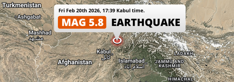
A significant Magnitude 5.8 earthquake struck under land 38 kilometer from Bāzārak in Afghanistan in the late afternoon of Friday February 20th, 2026. Around 35 million people have been exposed to shaking. Other countries near the epicenter include Pakistan, Tajikistan and Uzbekistan.
Felt the earthquake? Share this article: 


Earthquake Summary
The earthquake struck on land in Afghanistan, 38 kilometer (24 mi) north-east of Bāzārak in Panjshir. The center of this earthquake had an intermediate depth of 82 km.
| Date and Time: | Feb 20, 2026 05:39PM (Kabul Time) - Feb 20, 2026 13:09 Universal Time. |
|---|---|
| Location: | 38 km NE of Bāzārak, Panjshir, Afghanistan. Coordinates 35°35'38"N 69°44'52"E. |
| Map: | 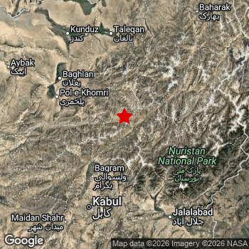 Map of area around epicenter. Click to open in Google Maps. |
| Magnitude: | MAG 5.8 Detected by 27 stations. Maximum Error Range ±0.06 . |
| Depth: | 82 km (51 mi) An intermediate depth. |
| Max. Intensity: | V
Moderate On the Modified Mercalli Scale. |
| Tsunami Risk: | Tsunami very unlikely While this was a shallow earthquake, it appears to have occurred under land with a magnitude not strong enough to cause tsunami's. Always stay cautious - More info here. |
Minimal impact predicted
The US Geographic Survey (USGS) describes the impact of this earthquake as follows:
One person injured in Takhar and 3 homes damaged in Laghman.
Based on scientific estimates by the USGS, the risk of high fatalities for this earthquake is classified at level GREEN (low). They expect an 90% likelyhood of between 0 and 1 fatalities.
The USGS classifies the economic impact of this earthquake at level GREEN (low). They expect an 90% likelyhood of between 0 and 1 million US Dollars in economic damage and impact.
Roughly 35 million people exposed to shaking
This earthquake may have been felt by around 35 million people. That is the expected population size of the area exposed to a level of shaking of II or higher on the Modified Mercalli scale according to the USGS.
An estimated 4,308,000 people were exposed to level IV. At this level, light shaking and likely no damage can be expected. Intensity level III was experienced by the majority of people (around 31 million). In their region, weak shaking and probably no damage can be expected.
People in 4 countries have been exposed to shaking. In Afghanistan , around 19 million people, with impact levels up to IV (light shaking, likely no damage). In Pakistan , around 16 million people. A smaller number of people were exposed in the following countries: Tajikistan and Uzbekistan.
| People | MMI Level | Shaking | Damage |
|---|---|---|---|
| 0 | I |
Not noticable | None |
| 377,500 | II |
Very weak | None |
| 30,680,000 | III |
Weak | Probably none |
| 4,308,000 | IV |
Light | Likely none |
| 0 | V |
Moderate | Very light |
| 0 | VI |
Strong | Light |
| 0 | VII |
Very Strong | Moderate |
| 0 | VIII |
Severe | Moderate to heavy |
| 0 | IX |
Violent | Heavy |
| 0 | X |
Extreme | Very heavy |
Nearby towns and cities
Afghanistan , Pakistan , Tajikistan and Uzbekistan are all located within 300km distance of the epicenter of the earthquake.
Bāzārak in Panjshir, Afghanistan is the nearest significant place from the epicenter. The earthquake occurred 38 kilometer (24 mi) north-east of Bāzārak. The intensity of shaking and damage in Bāzārak is estimated to be around level IV on the Modified Mercalli Intensity scale (light shaking, likely no damage).
Multiple large cities are in proximity of today's earthquake. Kabul is located 130 km to the southwest and experienced an intensity of III (weak shaking, probably no damage). Peshawar is located 243 km to the south-east and experienced an intensity of III (weak shaking, probably no damage). Rawalpindi is located 375 km to the south-east (intensity unknown, possibly low).
The table below provides an overview of all places in proximity of today's earthquake. Where available, the estimated intensity on the Modified Mercalli Intensity Scale in each place is included. Places where this information is omitted likely experienced little impact.
Overview of nearby places
| Distance | Place | Intensity (MMI) |
|---|---|---|
| 38 km (24 mi) SW from epicenter |
Bāzārak Panjshir, Afghanistan. |
IV
Light |
| 70 km (43 mi) SW from epicenter |
Jabal os Saraj Parwan, Afghanistan. |
IV
Light |
| 76 km (47 mi) NW from epicenter |
Nahrīn Baghlan, Afghanistan. |
IV
Light |
| 83 km (52 mi) SW from epicenter |
Charikar Parwan, Afghanistan. |
IV
Light |
| 101 km (63 mi) W from epicenter |
Pul-e Khumrī Baghlan, Afghanistan. |
III
Weak |
| 111 km (69 mi) SE from epicenter |
Mehtar Lām Laghman, Afghanistan. |
III
Weak |
| 111 km (69 mi) NW from epicenter |
Baghlān Baghlan, Afghanistan. |
IV
Light |
| 128 km (80 mi) N from epicenter |
Taloqan Takhar, Afghanistan. |
IV
Light |
| 130 km (81 mi) SW from epicenter |
Kabul Kabul, Afghanistan. |
III
Weak |
| 133 km (83 mi) SW from epicenter |
Paghmān Kabul, Afghanistan. |
III
Weak |
| 134 km (83 mi) NW from epicenter |
Khanabad Kunduz, Afghanistan. |
III
Weak |
| 145 km (90 mi) SE from epicenter |
Jalālābād Nangarhar, Afghanistan. |
III
Weak |
| 149 km (93 mi) NW from epicenter |
Kunduz Kunduz, Afghanistan. |
III
Weak |
| 150 km (93 mi) SE from epicenter |
Asadābād Kunar, Afghanistan. |
III
Weak |
| 159 km (99 mi) SE from epicenter |
Āsmār Kunar, Afghanistan. |
III
Weak |
| 168 km (104 mi) N from epicenter |
Ārt Khwājah Takhar, Afghanistan. |
III
Weak |
| 171 km (106 mi) N from epicenter |
Rustāq Takhar, Afghanistan. |
III
Weak |
| 173 km (107 mi) NW from epicenter |
Aībak Samangan, Afghanistan. |
III
Weak |
| 185 km (115 mi) NE from epicenter |
Fayzabad Badakhshan, Afghanistan. |
III
Weak |
| 185 km (115 mi) SE from epicenter |
Markaz-e Woluswalī-ye Āchīn Nangarhar, Afghanistan. |
III
Weak |
| 194 km (121 mi) SW from epicenter |
Bāmyān Bamyan, Afghanistan. |
III
Weak |
| 195 km (121 mi) S from epicenter |
Baraki Barak Logar, Afghanistan. |
III
Weak |
| 198 km (123 mi) E from epicenter |
Upper Dir Khyber Pakhtunkhwa, Pakistan. |
III
Weak |
| 200 km (124 mi) NW from epicenter |
Qarāwul Kunduz, Afghanistan. |
III
Weak |
| 209 km (130 mi) NE from epicenter |
Ishqoshim Gorno-Badakhshan, Tajikistan. |
III
Weak |
| 221 km (137 mi) NW from epicenter |
Khulm Balkh, Afghanistan. |
III
Weak |
| 225 km (140 mi) SE from epicenter |
Tangi Khyber Pakhtunkhwa, Pakistan. |
III
Weak |
| 225 km (140 mi) SE from epicenter |
Shabqadar Khyber Pakhtunkhwa, Pakistan. |
III
Weak |
| 227 km (141 mi) S from epicenter |
Gardez Paktia, Afghanistan. |
|
| 230 km (143 mi) SE from epicenter |
Bat Khela Khyber Pakhtunkhwa, Pakistan. |
III
Weak |
| 243 km (151 mi) SE from epicenter |
Charsadda Khyber Pakhtunkhwa, Pakistan. |
III
Weak |
| 243 km (151 mi) SE from epicenter |
Peshawar Khyber Pakhtunkhwa, Pakistan. |
III
Weak |
| 251 km (156 mi) S from epicenter |
Khōst Khowst, Afghanistan. |
|
| 254 km (158 mi) E from epicenter |
Mingora Khyber Pakhtunkhwa, Pakistan. |
|
| 257 km (160 mi) SW from epicenter |
Ghazni Ghazni, Afghanistan. |
|
| 258 km (160 mi) N from epicenter |
Kŭlob Khatlon, Tajikistan. |
|
| 261 km (162 mi) SE from epicenter |
Mardan Khyber Pakhtunkhwa, Pakistan. |
|
| 264 km (164 mi) N from epicenter |
Bokhtar Khatlon, Tajikistan. |
|
| 267 km (166 mi) NW from epicenter |
Mazār-e Sharīf Balkh, Afghanistan. |
|
| 270 km (168 mi) W from epicenter |
Bāzār-e Yakāwlang Bamyan, Afghanistan. |
|
| 271 km (168 mi) SE from epicenter |
Nowshera Cantonment Khyber Pakhtunkhwa, Pakistan. |
III
Weak |
| 273 km (170 mi) SE from epicenter |
Kohat Khyber Pakhtunkhwa, Pakistan. |
|
| 286 km (178 mi) NW from epicenter |
Tirmiz Surxondaryo, Uzbekistan. |
|
| 287 km (178 mi) NW from epicenter |
Balkh Balkh, Afghanistan. |
|
| 292 km (181 mi) SE from epicenter |
Tordher Khyber Pakhtunkhwa, Pakistan. |
|
| 298 km (185 mi) SE from epicenter |
Swabi Khyber Pakhtunkhwa, Pakistan. |
|
| 315 km (196 mi) E from epicenter |
Battagram Khyber Pakhtunkhwa, Pakistan. |
|
| 336 km (209 mi) N from epicenter |
Vahdat Republican Subordination, Tajikistan. |
|
| 338 km (210 mi) N from epicenter |
Dushanbe Dushanbe, Tajikistan. |
|
| 350 km (217 mi) W from epicenter |
Sar-e Pul Sar-e Pol, Afghanistan. |
|
| 365 km (227 mi) E from epicenter |
Muzaffarābād Azad Kashmir, Pakistan. |
|
| 366 km (227 mi) SE from epicenter |
Islamabad Islamabad, Pakistan. |
|
| 375 km (233 mi) SE from epicenter |
Rawalpindi Punjab, Pakistan. |
|
| 378 km (235 mi) W from epicenter |
Shibirghān Jowzjan, Afghanistan. |
Earthquake Intensity Map
The maximum intensity (MMI Scale) caused by this earthquake is IV. The map below shows in which areas this earthquake was the most and least impactful. It is based on data from the US Geographic Survey.

Shaking reported by 7 people in 2 countries
People that feel an earthquake may report their experience to the US Geographic Survey. Currently, 7 people have reported shaking in 3 places in 2 countries (Afghanistan, Pakistan).We keep updating this article as more ground reports become available. You may report that you felt this earthquake here.
Places with most reports:
- Kabul, Kabul, Afghanistan: 5 people.
- Peshawar, North-West Frontier, Pakistan: 1 person.
- Abottabad, North-West Frontier, Pakistan: 1 person.
Risk of aftershocks?
We monitor for foreshocks or aftershocks that have a magnitude of 2.5+ and occur within 100km (62 mi) of the epicenter of this earthquake. So far no such earthquakes have been detected.
Earthquakes can create aftershocks. These are generally at least 1 magnitude lower than any main shock, and as time passes the chance and strength of aftershocks decreases.
It's always adviced to be cautious of the risk of a larger shock following any significant earthquake, however this risk is fairly small. There is a roughly 94 percent change that no larger main shock will follow in the days following this earthquake.
Read: How to Stay Safe during an Earthquake (cdc.gov).Earthquakes like this happen often in the region
Earthquakes of this strength are very common in the region. This is the strongest earthquake to hit since November 2nd, 2025, when a 6.2 magnitude earthquake hit 237 km (147 mi) further northwest. An even stronger magnitude 6.6 earthquake struck on April 10th, 2016.
In total, 14 earthquakes with a magnitude of 5.8 or higher have been registered within 300km (186 mi) of this epicenter in the past 10 years. This comes down to an average of once every 9 months.
Tsunami very unlikely
While MAG-6.5+ earthquakes may cause tsunami's, it appears that the epicenter of this earthquake hit under land. In addition, the reported depth is deeper than 100km, making the risk of a tsunami even less likely. However always stay cautious and monitor advice from local authorities.
Tsunami Risk Factors
| Factor | Under Sea? | MAG-6.5 or stronger? | Shallow depth? |
|---|---|---|---|
| Explanation | Almost all tsunami's are caused by earthquakes with their epicenter under sea or very near the sea. However stay cautious in coastal areas as earthquakes on land may cause landslides into sea, potentially still causing a local tsunami. | Under MAG 6.5: Very unlikely to cause a tsunami. MAG 6.5 to 7.5: Destructive tsunami's do occur, but are uncommon. Likely to observe small sea level changes. MAG 7.6+: Earthquakes with these magnitudes might produce destructive tsunami's. |
Most destructive tsunami's are caused by shallow earthquakes with a depth between 0 and 100km under the surface of the earth. Deeper tsunami's are unlikely to displace to ocean floor. |
| This Earthquake | Not this earthquake. This earthquake appears to have struck on land far from any coast. |
Not this earthquake. This earthquake had a magnitude of 5.8. Earthquakes of this strength are unlikely to trigger a tsunami. |
This earthquake occurred at a depth of of 82 km (51 mi). Earthquakes this shallow could trigger a tsunami. |
Sources
Last updated 31/03/26 17:58 (). This article contains currently available information about the earthquake and is automatically composed. We continue to update this article up to a few days after the earthquake occurred.
- US Geographic Society (USGS): Earthquake us6000sadt
- European-Mediterranean Seismological Centre (EMSC): Earthquake 20260220_0000192
- Geonames.org: World Cities Database
- Google Maps: Static API
- Earthquakelist.org: Historic Earthquakes Database
Share this article:
