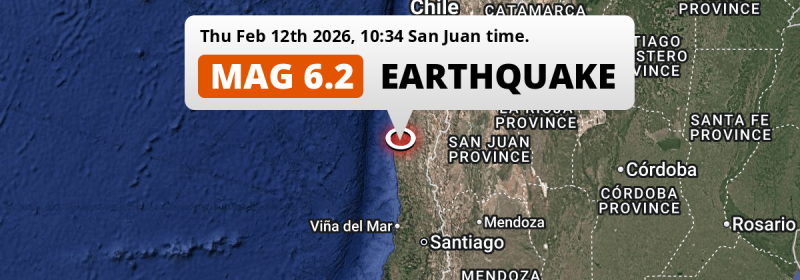
Under land 32 kilometer from Ovalle in Chile, a strong Magnitude 6.2 earthquake occurred in the morning of Thursday February 12th, 2026. Roughly 0.9 million people may have felt this earthquake. Argentina is also near its epicenter.
Felt the earthquake? Share this article: 


Earthquake Summary
The earthquake struck on land in Chile, 32 kilometer (20 mi) southwest of Ovalle in Coquimbo Region. The center of this earthquake had a quite shallow depth of 37 km. Shallow earthquakes usually have a larger impact than earthquakes deep in the earth.
| Date and Time: | Feb 12, 2026 10:34 (Santiago Time) - Feb 12, 2026 13:34 Universal Time. |
|---|---|
| Location: | 32 km SW of Ovalle, Coquimbo Region, Chile. Coordinates 30°48'4"S 71°26'42"W. |
| Map: | 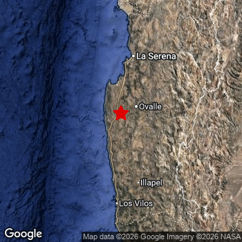 Map of area around epicenter. Click to open in Google Maps. |
| Magnitude: | MAG 6.2 Detected by 31 stations. Maximum Error Range ±0.056 . |
| Depth: | 37 km (23 mi) A quite shallow depth. |
| Max. Intensity: | VI
Strong On the Modified Mercalli Scale. |
| Tsunami Risk: | Tsunami very unlikely While this was a shallow earthquake in a coastal area, it appears to have occurred under land (24 km from the sea) with a magnitude that is usually not strong enough to cause tsunami's. Always stay cautious - More info here. |
Minimal impact predicted
Based on scientific estimates by the US Geographic Survey (USGS), the risk of high fatalities for this earthquake is classified at level GREEN (low). They expect an 65% likelyhood of between 0 and 1 fatalities, and a 96% chance that the number of fatalities falls no higher than 10.
The USGS classifies the economic impact of this earthquake at level GREEN (low). They expect an 100% likelyhood of between 0 and 1 million US Dollars in economic damage and impact.
Roughly 0.9 million people exposed to shaking
This earthquake may have been felt by around 0.9 million people. That is the expected population size of the area exposed to a level of shaking of II or higher on the Modified Mercalli scale according to the USGS.
The highest earthquake impact level for this earthquake is VI, which corresponds with strong shaking and probably light damage. Roughly 6,560 people are expected to be exposed to this level. Intensity level IV was experienced by the majority of people (around 520 thousand). In their region, light shaking and likely no damage can be expected.
People in 2 countries have been exposed to shaking. In Chile , around 0.9 million people, with impact levels up to VI (strong shaking, probably light damage). Shaking was experienced by inhabitants of Argentina too.
| People | MMI Level | Shaking | Damage |
|---|---|---|---|
| 0 | I |
Not noticable | None |
| 0 | II |
Very weak | None |
| 91,170 | III |
Weak | Probably none |
| 522,100 | IV |
Light | Likely none |
| 317,600 | V |
Moderate | Very light |
| 6,560 | VI |
Strong | Light |
| 0 | VII |
Very Strong | Moderate |
| 0 | VIII |
Severe | Moderate to heavy |
| 0 | IX |
Violent | Heavy |
| 0 | X |
Extreme | Very heavy |
Nearby towns and cities
2 countries can be found within 300km of the epicenter of this earthquake: Chile and Argentina .
Located 32 kilometer (20 mi) southwest of the epicenter of this earthquake, Ovalle (Coquimbo Region, Chile) is the nearest significant population center. Ovalle experienced an earthquake intensity (MMI Scale) of roughly V. That level implies moderate shaking and very light damage.
Major cities near this earthquake: Santiago is located 305 km to the south-southeast (intensity unknown, possibly low). Mendoza is located 339 km to the south-east (intensity unknown, possibly low). Coquimbo is located 95 km to the north and experienced an intensity of IV (light shaking, likely no damage).
The table below provides an overview of all places in proximity of today's earthquake. Where available, the estimated intensity on the Modified Mercalli Intensity Scale in each place is included. Places where this information is omitted likely experienced little impact.
Overview of nearby places
| Distance | Place | Intensity (MMI) |
|---|---|---|
| 32 km (20 mi) NE from epicenter |
Ovalle Coquimbo Region, Chile. |
V
Moderate |
| 95 km (59 mi) N from epicenter |
Coquimbo Coquimbo Region, Chile. |
IV
Light |
| 96 km (60 mi) SSE from epicenter |
Illapel Coquimbo Region, Chile. |
IV
Light |
| 101 km (63 mi) N from epicenter |
La Serena Coquimbo Region, Chile. |
V
Moderate |
| 185 km (115 mi) S from epicenter |
La Ligua Valparaíso, Chile. |
III
Weak |
| 221 km (137 mi) S from epicenter |
Hacienda La Calera Valparaíso, Chile. |
|
| 227 km (141 mi) SSE from epicenter |
San Felipe Valparaíso, Chile. |
|
| 231 km (144 mi) SSE from epicenter |
Llaillay Valparaíso, Chile. |
|
| 232 km (144 mi) S from epicenter |
Quillota Valparaíso, Chile. |
|
| 240 km (149 mi) SSE from epicenter |
Los Andes Valparaíso, Chile. |
|
| 247 km (153 mi) S from epicenter |
Limache Valparaíso, Chile. |
|
| 247 km (153 mi) S from epicenter |
Viña del Mar Valparaíso, Chile. |
|
| 249 km (155 mi) S from epicenter |
Villa Alemana Valparaíso, Chile. |
|
| 249 km (155 mi) S from epicenter |
Valparaíso Valparaíso, Chile. |
|
| 250 km (155 mi) S from epicenter |
Quilpué Valparaíso, Chile. |
|
| 256 km (159 mi) NNE from epicenter |
Vallenar Atacama, Chile. |
|
| 266 km (165 mi) ENE from epicenter |
San José de Jáchal San Juan, Argentina. |
|
| 281 km (175 mi) S from epicenter |
Lampa Santiago Metropolitan, Chile. |
|
| 286 km (178 mi) SSE from epicenter |
Chicureo Abajo Santiago Metropolitan, Chile. |
|
| 287 km (178 mi) ESE from epicenter |
Albardón San Juan, Argentina. |
|
| 287 km (178 mi) ESE from epicenter |
Villa Paula de Sarmiento San Juan, Argentina. |
|
| 287 km (178 mi) ESE from epicenter |
Chimbas San Juan, Argentina. |
|
| 289 km (180 mi) ESE from epicenter |
Pocito San Juan, Argentina. |
|
| 289 km (180 mi) ESE from epicenter |
San Juan San Juan, Argentina. |
|
| 292 km (181 mi) ESE from epicenter |
Santa Lucía San Juan, Argentina. |
|
| 302 km (188 mi) SSE from epicenter |
Lo Prado Santiago Metropolitan, Chile. |
|
| 305 km (190 mi) SSE from epicenter |
Santiago Santiago Metropolitan, Chile. |
|
| 306 km (190 mi) S from epicenter |
Cartagena Valparaíso, Chile. |
|
| 311 km (193 mi) S from epicenter |
San Antonio Valparaíso, Chile. |
|
| 315 km (196 mi) ESE from epicenter |
Caucete San Juan, Argentina. |
|
| 316 km (196 mi) S from epicenter |
Peñaflor Santiago Metropolitan, Chile. |
|
| 318 km (198 mi) SSE from epicenter |
San Bernardo Santiago Metropolitan, Chile. |
|
| 319 km (198 mi) SSE from epicenter |
La Pintana Santiago Metropolitan, Chile. |
|
| 322 km (200 mi) S from epicenter |
Talagante Santiago Metropolitan, Chile. |
|
| 322 km (200 mi) S from epicenter |
Melipilla Santiago Metropolitan, Chile. |
|
| 323 km (201 mi) SSE from epicenter |
Puente Alto Santiago Metropolitan, Chile. |
|
| 323 km (201 mi) S from epicenter |
El Monte Santiago Metropolitan, Chile. |
|
| 333 km (207 mi) SSE from epicenter |
Buin Santiago Metropolitan, Chile. |
|
| 339 km (211 mi) SE from epicenter |
Mendoza Mendoza, Argentina. |
|
| 341 km (212 mi) SSE from epicenter |
Paine Santiago Metropolitan, Chile. |
|
| 370 km (230 mi) S from epicenter |
Graneros O'Higgins Region, Chile. |
|
| 378 km (235 mi) SE from epicenter |
San Martín Mendoza, Argentina. |
|
| 380 km (236 mi) S from epicenter |
Rancagua O'Higgins Region, Chile. |
|
| 383 km (238 mi) SSE from epicenter |
Machalí O'Higgins Region, Chile. |
|
| 397 km (247 mi) NNE from epicenter |
Copiapó Atacama, Chile. |
Earthquake Intensity Map
The intensity in shaking and damage by this earthquake is illustrated through the map below. The highest intensity measured for this earthquake is VI.

Shaking reported by 122 people in 2 countries
People that feel an earthquake may report their experience to the US Geographic Survey. Currently, 122 people have reported shaking in 26 places in 2 countries (Chile, Argentina).We keep updating this article as more ground reports become available. You may report that you felt this earthquake here.
Places with most reports:
- Santiago, Metropolitana, Chile: 54 people.
- Mendoza, Mendoza, Argentina: 11 people.
- La Serena, Coquimbo, Chile: 11 people.
- Coquimbo, Coquimbo, Chile: 10 people.
- Illapel, Coquimbo, Chile: 4 people.
- San Juan, San Juan, Argentina: 3 people.
- San Bernardo, Metropolitana, Chile: 3 people.
- Viña del Mar, Valparaíso, Chile: 2 people.
- Vicuña, Coquimbo, Chile: 2 people.
- Calera, Valparaíso, Chile: 2 people.
13 Aftershocks detected
This main shock was followed by 13 smaller aftershocks. A 4.3 magnitude earthquake hit 11 hrs later 8 km (5 mi) northwest of this earthquake.
This main shock was prefaced by 3 smaller foreshocks. Roughly 3 days before this earthquake, a foreshock measuring MAG-3.9 was detected nearby this earthquake.
Overview of foreshocks and aftershocks
| Classification | Magnitude | When | Where |
|---|---|---|---|
| Foreshock | M 3.9 |
3 days earlier Feb 9, 2026 13:28 (Santiago Time) | 85 km (53 mi) SSW from Main Shock. |
| Foreshock | M 3.1 |
1 day earlier Feb 11, 2026 06:59 (Santiago Time) | 83 km (51 mi) S from Main Shock. |
| Foreshock | M 2.6 |
22 mins earlier Feb 12, 2026 10:12 (Santiago Time) | 90 km (56 mi) S from Main Shock. |
| Main Shock This Earthquake |
M 6.2 |
Feb 12, 2026 10:34 (Santiago Time) | - |
| Aftershock | M 4.1 |
13 mins later Feb 12, 2026 10:47 (Santiago Time) | 9 km (6 mi) E from Main Shock. |
| Aftershock | M 3.0 |
16 mins later Feb 12, 2026 10:50 (Santiago Time) | 4 km (2.5 mi) SE from Main Shock. |
| Aftershock | M 2.8 |
27 mins later Feb 12, 2026 11:01 (Santiago Time) | 13 km (8 mi) ENE from Main Shock. |
| Aftershock | M 2.6 |
50 mins later Feb 12, 2026 11:24 (Santiago Time) | 6 km (4 mi) E from Main Shock. |
| Aftershock | M 4.1 |
5 hrs later Feb 12, 2026 15:19 (Santiago Time) | 8 km (5 mi) E from Main Shock. |
| Aftershock | M 4.3 |
11 hrs later Feb 12, 2026 21:58 (Santiago Time) | 8 km (5 mi) NW from Main Shock. |
| Aftershock | M 2.6 |
1 day later Feb 13, 2026 18:24 (Santiago Time) | 6 km (4 mi) NE from Main Shock. |
| Aftershock | M 3.4 |
1 day later Feb 13, 2026 18:48 (Santiago Time) | 1.4 km (0.9 mi) E from Main Shock. |
| Aftershock | M 2.7 |
1 day later Feb 13, 2026 19:10 (Santiago Time) | 52 km (32 mi) SE from Main Shock. |
| Aftershock | M 3.8 |
2 days later Feb 13, 2026 23:45 (Santiago Time) | 15 km (9 mi) ENE from Main Shock. |
| Aftershock | M 2.6 |
2 days later Feb 14, 2026 08:15 (Santiago Time) | 13 km (8 mi) E from Main Shock. |
| Aftershock | M 3.6 |
2 days later Feb 14, 2026 09:35 (Santiago Time) | 8 km (5 mi) ENE from Main Shock. |
| Aftershock | M 3.6 |
3 days later Feb 15, 2026 05:36 (Santiago Time) | 17 km (11 mi) SSE from Main Shock. |
More earthquakes coming?
Aftershocks are usually at least 1 order of magnitude less strong than main shocks. The more time passes, the smaller the chance and likely strength of any potential aftershocks.
It's always adviced to be cautious of the risk of a larger shock following any significant earthquake, however this risk is fairly small. There is a roughly 94 percent change that no larger main shock will follow in the days following this earthquake.
Read: How to Stay Safe during an Earthquake (cdc.gov).Earthquakes like this are common in the region
Earthquakes of this strength occur quite regularly in the region. This is the strongest earthquake to hit since October 31st, 2023, when a 6.6 magnitude earthquake hit 229 km (142 mi) further north. An even stronger magnitude 6.9 earthquake struck on April 24th, 2017.
In total, 8 earthquakes with a magnitude of 6.2 or higher have been registered within 300km (186 mi) of this epicenter in the past 10 years. This comes down to an average of once every year.
Tsunami very unlikely
While MAG-6.5+ earthquakes may cause tsunami's, it appears that the epicenter of this earthquake hit under land. In addition, the reported depth is deeper than 100km, making the risk of a tsunami even less likely. However always stay cautious and monitor advice from local authorities.
Tsunami Risk Factors
| Factor | Under Sea? | MAG-6.5 or stronger? | Shallow depth? |
|---|---|---|---|
| Explanation | Almost all tsunami's are caused by earthquakes with their epicenter under sea or very near the sea. However stay cautious in coastal areas as earthquakes on land may cause landslides into sea, potentially still causing a local tsunami. | Under MAG 6.5: Very unlikely to cause a tsunami. MAG 6.5 to 7.5: Destructive tsunami's do occur, but are uncommon. Likely to observe small sea level changes. MAG 7.6+: Earthquakes with these magnitudes might produce destructive tsunami's. |
Most destructive tsunami's are caused by shallow earthquakes with a depth between 0 and 100km under the surface of the earth. Deeper tsunami's are unlikely to displace to ocean floor. |
| This Earthquake | This earthquake appears to have struck on land near a coastal area (24 km from the sea). | Not this earthquake. This earthquake had a magnitude of 6.2. Earthquakes of this strength are unlikely to trigger a tsunami. |
This earthquake occurred at a depth of of 37 km (23 mi). Earthquakes this shallow could trigger a tsunami. |
Sources
Last updated 19/02/26 00:08 (). This article contains currently available information about the earthquake and is automatically composed. We continue to update this article up to a few days after the earthquake occurred.
- US Geographic Society (USGS): Earthquake us6000s8gw
- European-Mediterranean Seismological Centre (EMSC): Earthquake 20260212_0000155
- Geonames.org: World Cities Database
- Google Maps: Static API
- Earthquakelist.org: Historic Earthquakes Database
Share this article:
