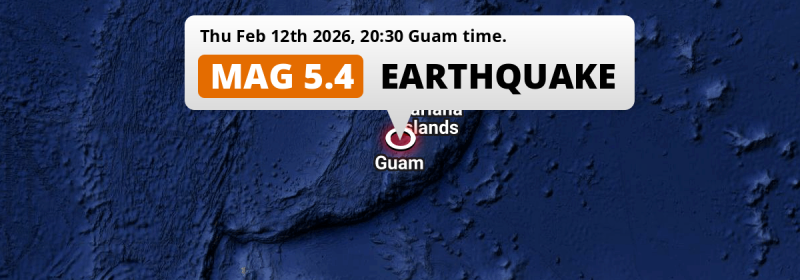
A significant MAG-5.4 earthquake struck in the Philippine Sea 49 kilometer from Dededo Village, Guam in the evening of Thursday February 12th, 2026. Around 230 thousand people have been exposed to shaking. Another country near the epicenter is Northern Mariana Islands.
Felt the earthquake? Share this article: 


Earthquake Summary
This earthquake hit under water in the Philippine Sea, 35 kilometers (22 mi) off the coast of Guam, 49 kilometer north of Dededo Village in Dededo. The center of this earthquake had an intermediate depth of 149 km.
| Date and Time: | Feb 12, 2026 20:30 (Guam Time) - Feb 12, 2026 10:30 Universal Time. |
|---|---|
| Location: | 49 km north of Dededo Village, Dededo, Guam. Coordinates 13°57'38"N 144°47'60"E. |
| Map: | 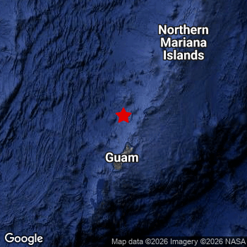 Map of area around epicenter. Click to open in Google Maps. |
| Magnitude: | MAG 5.4 Detected by 7 stations. Maximum Error Range ±0.083 . |
| Depth: | 149 km (93 mi) An intermediate depth. |
| Max. Intensity: | IV
Light On the Modified Mercalli Scale. |
| Tsunami Risk: | Tsunami very unlikely Earthquakes under MAG-6.5 at depths deeper than 100km are very unlikely to cause tsunami's. Always stay cautious - More info here. |
Minimal impact predicted
Based on scientific estimates by the US Geographic Survey (USGS), the risk of high fatalities for this earthquake is classified at level GREEN (low). They expect an 65% likelyhood of between 0 and 1 fatalities, and a 96% chance that the number of fatalities falls no higher than 10.
The USGS classifies the economic impact of this earthquake at level GREEN (low). They expect an 65% likelyhood of between 0 and 1 million US Dollars in economic damage and impact, and a 96% chance that the economic impact of this earthquake falls no higher than 10 million USD.
Roughly 230 thousand people exposed to shaking
An estimated 230 thousand have been exposed to shaking (An MMI or Modified Mercalli Intensity level II or higher) as a result of this earthquake according scientific estimates published by the USGS.
An estimated 1,840 people were exposed to level IV. At this level, light shaking and likely no damage can be expected. The majority of people (roughly 210 thousand) live in an area exposed to level III, where weak shaking and probably no damage is expected.
People in 2 countries have been exposed to shaking. In Guam , around 180 thousand people, with impact levels up to IV (light shaking, likely no damage). In Northern Mariana Islands , around 50 thousand people.
| People | MMI Level | Shaking | Damage |
|---|---|---|---|
| 0 | I |
Not noticable | None |
| 17,860 | II |
Very weak | None |
| 208,000 | III |
Weak | Probably none |
| 1,840 | IV |
Light | Likely none |
| 0 | V |
Moderate | Very light |
| 0 | VI |
Strong | Light |
| 0 | VII |
Very Strong | Moderate |
| 0 | VIII |
Severe | Moderate to heavy |
| 0 | IX |
Violent | Heavy |
| 0 | X |
Extreme | Very heavy |
Nearby towns and cities
Guam and Northern Mariana Islands are both located within 300km distance of the epicenter of the earthquake.
The closest significant population center near the earthquake is Yigo Village in Yigo, Guam. Yigo Village is located 48 kilometer (30 mi) north-northwest of the epicenter. The intensity of shaking and damage in Yigo Village is estimated to be around level III on the Modified Mercalli Intensity scale (weak shaking, probably no damage).
The table below provides an overview of all places in proximity of today's earthquake. Where available, the estimated intensity on the Modified Mercalli Intensity Scale in each place is included. Places where this information is omitted likely experienced little impact.
Overview of nearby places
| Distance | Place | Intensity (MMI) |
|---|---|---|
| 48 km (30 mi) SSE from epicenter |
Yigo Village Yigo, Guam. |
III
Weak |
| 49 km (30 mi) S from epicenter |
Dededo Village Dededo, Guam. |
III
Weak |
| 53 km (33 mi) S from epicenter |
Tamuning-Tumon-Harmon Village Tamuning, Guam. |
III
Weak |
| 53 km (33 mi) S from epicenter |
Tamuning Tamuning, Guam. |
III
Weak |
| 54 km (34 mi) S from epicenter |
Hagåtña Hagatna, Guam. |
III
Weak |
| 55 km (34 mi) S from epicenter |
Guam Government House Hagatna, Guam. |
III
Weak |
| 57 km (35 mi) S from epicenter |
Mangilao Village Mangilao, Guam. |
III
Weak |
| 173 km (107 mi) NE from epicenter |
Saipan Saipan, Northern Mariana Islands. |
II
Weak |
Earthquake Intensity Map
The intensity in shaking and damage by this earthquake is illustrated through the map below. The highest intensity measured for this earthquake is IV.

Risk of aftershocks?
We have not yet detected any foreshocks or aftershocks (MAG-2.5 or higher) within 100km (62 mi) of this earthquake.
Aftershocks are usually at least 1 order of magnitude less strong than main shocks. The more time passes, the smaller the chance and likely strength of any potential aftershocks.
It's always adviced to be cautious of the risk of a larger shock following any significant earthquake, however this risk is fairly small. There is a roughly 94 percent change that no larger main shock will follow in the days following this earthquake.
Read: How to Stay Safe during an Earthquake (cdc.gov).Earthquakes like this happen often in the region
Earthquakes of this strength are very common in the region. This is the strongest earthquake to hit since December 24th, 2025, when a 5.7 magnitude earthquake hit 286 km (178 mi) further south-southwest. An even stronger magnitude 6 earthquake struck on November 4th, 2025.
In total, 42 earthquakes with a magnitude of 5.4 or higher have been registered within 300km (186 mi) of this epicenter in the past 10 years. This comes down to an average of once every 3 months.
Tsunami very unlikely
For a serious tsunami to occur, earthquakes usually need to have a magnitude of at least 6.5 and occur at a shallow depth of maximum 100km. Neither are the case with this earthquake. However always stay cautious and monitor advice from local authorities.
Tsunami Risk Factors
| Factor | Under Sea? | MAG-6.5 or stronger? | Shallow depth? |
|---|---|---|---|
| Explanation | Almost all tsunami's are caused by earthquakes with their epicenter under sea or very near the sea. However stay cautious in coastal areas as earthquakes on land may cause landslides into sea, potentially still causing a local tsunami. | Under MAG 6.5: Very unlikely to cause a tsunami. MAG 6.5 to 7.5: Destructive tsunami's do occur, but are uncommon. Likely to observe small sea level changes. MAG 7.6+: Earthquakes with these magnitudes might produce destructive tsunami's. |
Most destructive tsunami's are caused by shallow earthquakes with a depth between 0 and 100km under the surface of the earth. Deeper tsunami's are unlikely to displace to ocean floor. |
| This Earthquake | This earthquake appears to have struck under the sea. | Not this earthquake. This earthquake had a magnitude of 5.4. Earthquakes of this strength are unlikely to trigger a tsunami. |
Not this earthquake. This earthquake occurred at a depth of 149 km (93 mi). Earthquakes this deep in the earth are unlikely to trigger a tsunami. |
Sources
Last updated 19/02/26 00:08 (). This article is automatically generated based on available data. We keep checking multiple sources for additional information. This article gets updated as new details on this earthquake become available.
- US Geographic Society (USGS): Earthquake us6000s8gh
- European-Mediterranean Seismological Centre (EMSC): Earthquake 20260212_0000115
- Geonames.org: World Cities Database
- Google Maps: Static API
- Earthquakelist.org: Historic Earthquakes Database
Share this article:
