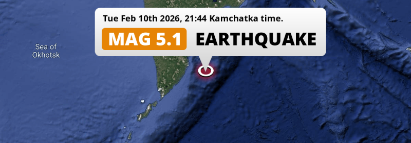
In the evening of Tuesday February 10th, 2026, a significant M5.1 aftershock hit in the North Pacific Ocean 145 kilometer from Petropavlovsk-Kamchatsky, Russia.
Felt the earthquake? Share this article: 


Earthquake Summary
This earthquake hit under water in the North Pacific Ocean, 128 kilometers (80 mi) off the coast of Russia, 145 kilometer south-southeast of Petropavlovsk-Kamchatsky in Kamchatka. The center of this earthquake had a quite shallow depth of 49 km. Shallow earthquakes usually have a larger impact than earthquakes deep in the earth.
| Date and Time: | Feb 10, 2026 21:44 (Kamchatka Time) - Feb 10, 2026 09:44 Universal Time. |
|---|---|
| Location: | 145 km SSE of Petropavlovsk-Kamchatsky, Kamchatka, Russia. Coordinates 51°54'45"N 159°38'8"E. |
| Map: | 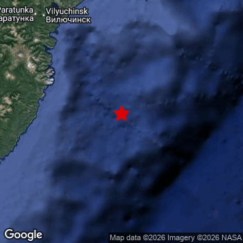 Map of area around epicenter. Click to open in Google Maps. |
| Magnitude: | MAG 5.1 Detected by 196 stations. Maximum Error Range ±0.041 . |
| Depth: | 49 km (31 mi) A quite shallow depth. |
| Tsunami Risk: | Low tsunami risk Earthquakes under MAG-6.5 do not usually cause tsunami's. Always stay cautious - More info here. |
Nearby towns and cities
This earthquake may have been felt in Russia . The closest significant population center near the earthquake is Vilyuchinsk in Kamchatka, Russia. Vilyuchinsk is located 141 kilometer (88 mi) south-east of the epicenter.
Overview of nearby places
| Distance | Place |
|---|---|
| 141 km (88 mi) NW from epicenter |
Vilyuchinsk Kamchatka, Russia. |
| 145 km (90 mi) NNW from epicenter |
Petropavlovsk-Kamchatsky Kamchatka, Russia. |
| 165 km (103 mi) NNW from epicenter |
Yelizovo Kamchatka, Russia. |
This is likely an aftershock
Approximately 1 day before this earthquake hit, a larger 5.3 magnitude earthquake struck 61 km (38 mi) south of this one. For that reason, we classify the Mag. 5.1 earthquake as an aftershock.
Overview of foreshocks and aftershocks
| Classification | Magnitude | When | Where |
|---|---|---|---|
| Foreshock | M 4.8 |
3 days earlier Feb 7, 2026 04:20 (Kamchatka Time) | 81 km (51 mi) SSE from Main Shock. |
| Main Shock | M 5.3 |
Feb 9, 2026 17:09 (Kamchatka Time) | - |
| Aftershock | M 4.4 |
1 hr later Feb 9, 2026 18:24 (Kamchatka Time) | 61 km (38 mi) SE from Main Shock. |
| Aftershock | M 4.4 |
2 hrs later Feb 9, 2026 18:55 (Kamchatka Time) | 70 km (44 mi) ESE from Main Shock. |
| Aftershock | M 4.4 |
3 hrs later Feb 9, 2026 20:28 (Kamchatka Time) | 32 km (20 mi) ESE from Main Shock. |
| Aftershock This Earthquake |
M 5.1 |
1 day later Feb 10, 2026 21:44 (Kamchatka Time) | 61 km (38 mi) N from Main Shock. |
| Aftershock | M 4.5 |
1 day later Feb 11, 2026 03:47 (Kamchatka Time) | 87 km (54 mi) NNW from Main Shock. |
| Aftershock | M 4.7 |
2 days later Feb 11, 2026 16:07 (Kamchatka Time) | 39 km (24 mi) SW from Main Shock. |
More earthquakes coming?
The risk of aftershocks decreases rapidly over time. Usually, aftershocks are at least one order of magnitude lower than a main shock.
In only six percent of cases, significant earthquakes are followed by a larger main shock, making the current earthquake a foreshock. While the chance of this happening is not so large, it is adviced to maintain cautiousness in the hours and days following a major earthquake.
Read: How to Stay Safe during an Earthquake (cdc.gov).Earthquakes like this happen often in the region
Earthquakes of this strength are very common in the region. In total, 289 earthquakes with a magnitude of 5.1 or higher have been registered within 300km (186 mi) of this epicenter in the past 10 years. This comes down to an average of once every 13 days.
Low tsunami risk
Based on early data it appears this earthquake was not strong enough (lower than MAG-6.5) to be likely to cause destructive tsunami's. However this earthquake appeared to have hit at a shallow depth under sea, so stay cautious and monitor advice from local authorities.
Tsunami Risk Factors
| Factor | Under Sea? | MAG-6.5 or stronger? | Shallow depth? |
|---|---|---|---|
| Explanation | Almost all tsunami's are caused by earthquakes with their epicenter under sea or very near the sea. However stay cautious in coastal areas as earthquakes on land may cause landslides into sea, potentially still causing a local tsunami. | Under MAG 6.5: Very unlikely to cause a tsunami. MAG 6.5 to 7.5: Destructive tsunami's do occur, but are uncommon. Likely to observe small sea level changes. MAG 7.6+: Earthquakes with these magnitudes might produce destructive tsunami's. |
Most destructive tsunami's are caused by shallow earthquakes with a depth between 0 and 100km under the surface of the earth. Deeper tsunami's are unlikely to displace to ocean floor. |
| This Earthquake | This earthquake appears to have struck under the sea. | Not this earthquake. This earthquake had a magnitude of 5.1. Earthquakes of this strength are unlikely to trigger a tsunami. |
This earthquake occurred at a depth of of 49 km (31 mi). Earthquakes this shallow could trigger a tsunami. |
Sources
Last updated 18/02/26 10:08 (). This article is automatically generated based on available data. We keep checking multiple sources for additional information. This article gets updated as new details on this earthquake become available.
- US Geographic Society (USGS): Earthquake us6000s7m0
- European-Mediterranean Seismological Centre (EMSC): Earthquake 20260210_0000126
- Geonames.org: World Cities Database
- Google Maps: Static API
- Earthquakelist.org: Historic Earthquakes Database
Share this article:
