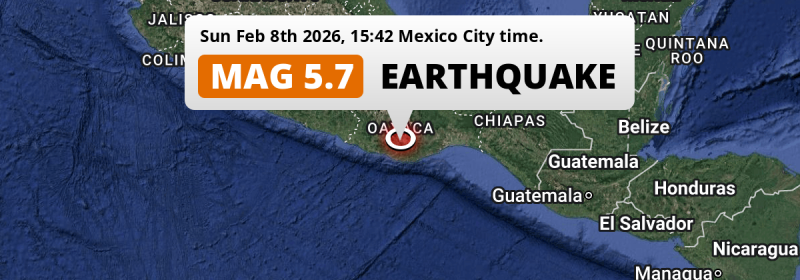
Under land 22 kilometer from Miahuatlán de Porfirio Díaz in Mexico, a shallow and significant MAG-5.7 earthquake occurred in the afternoon of Sunday February 8th, 2026. Around 4.2 million people have been exposed to shaking.
Felt the earthquake? Share this article: 


Earthquake Summary
The earthquake struck on land in Mexico, 22 kilometer (14 mi) south-southwest of Miahuatlán de Porfirio Díaz in Oaxaca. The center of this earthquake had a very shallow depth of 19 km. Shallow earthquakes usually have a larger impact than earthquakes deep in the earth.
| Date and Time: | Feb 8, 2026 15:42 (Mexico City Time) - Feb 8, 2026 21:42 Universal Time. |
|---|---|
| Location: | 22 km SSW of Miahuatlán de Porfirio Díaz, Oaxaca, Mexico. Coordinates 16°9'46"N 96°41'41"W. |
| Map: | 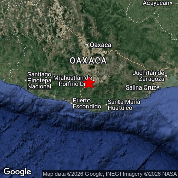 Map of area around epicenter. Click to open in Google Maps. |
| Magnitude: | MAG 5.7 Detected by 44 stations. Maximum Error Range ±0.047 . |
| Depth: | 19 km (12 mi) A very shallow depth. |
| Max. Intensity: | VI
Strong On the Modified Mercalli Scale. |
| Tsunami Risk: | Tsunami very unlikely While this was a shallow earthquake, it appears to have occurred under land with a magnitude not strong enough to cause tsunami's. Always stay cautious - More info here. |
Minimal impact predicted
Based on scientific estimates by the US Geographic Survey (USGS), the risk of high fatalities for this earthquake is classified at level GREEN (low). They expect an 65% likelyhood of between 0 and 1 fatalities, and a 96% chance that the number of fatalities falls no higher than 10.
The USGS classifies the economic impact of this earthquake at level GREEN (low). They expect an 65% likelyhood of between 0 and 1 million US Dollars in economic damage and impact, and a 96% chance that the economic impact of this earthquake falls no higher than 10 million USD.
Roughly 4.2 million people exposed to shaking
An estimated 4.2 million have been exposed to shaking (An MMI or Modified Mercalli Intensity level II or higher) as a result of this earthquake according scientific estimates published by the USGS.
The highest earthquake impact level for this earthquake is V, which corresponds with moderate shaking and very light damage. Roughly 36,190 people are expected to be exposed to this level. The majority of people (roughly 2.6 million) live in an area exposed to level III, where weak shaking and probably no damage is expected. All exposure to shaking was within the borders of Mexico .
| People | MMI Level | Shaking | Damage |
|---|---|---|---|
| 0 | I |
Not noticable | None |
| 413,100 | II |
Very weak | None |
| 2,587,000 | III |
Weak | Probably none |
| 1,205,000 | IV |
Light | Likely none |
| 36,190 | V |
Moderate | Very light |
| 0 | VI |
Strong | Light |
| 0 | VII |
Very Strong | Moderate |
| 0 | VIII |
Severe | Moderate to heavy |
| 0 | IX |
Violent | Heavy |
| 0 | X |
Extreme | Very heavy |
Nearby towns and cities
This earthquake may have been felt in Mexico . Located 22 kilometer (14 mi) south-southwest of the epicenter of this earthquake, Miahuatlán de Porfirio Díaz (Oaxaca, Mexico) is the nearest significant population center. The intensity of shaking and damage in Miahuatlán de Porfirio Díaz is estimated to be around level V on the Modified Mercalli Intensity scale (moderate shaking, very light damage).
Multiple large cities are in proximity of today's earthquake. Oaxaca is located 100 km to the north and experienced an intensity of IV (light shaking, likely no damage). Tehuacán is located 267 km to the north-northwest (intensity unknown, possibly low). Tuxtepec is located 222 km to the north-northeast (intensity unknown, possibly low).
A complete list of nearby places is included below. Estimated intensity data (MMI) sourced from a shake-map published by the US Geographic Survey is shown where available (cities without data probably experienced little impact).
Overview of nearby places
| Distance | Place | Intensity (MMI) |
|---|---|---|
| 22 km (14 mi) NNE from epicenter |
Miahuatlán de Porfirio Díaz Oaxaca, Mexico. |
V
Moderate |
| 52 km (32 mi) SW from epicenter |
Puerto Escondido Oaxaca, Mexico. |
IV
Light |
| 70 km (43 mi) N from epicenter |
Ocotlán de Morelos Oaxaca, Mexico. |
IV
Light |
| 74 km (46 mi) SE from epicenter |
Crucecita Oaxaca, Mexico. |
IV
Light |
| 96 km (60 mi) N from epicenter |
San Antonio de la Cal Oaxaca, Mexico. |
III
Weak |
| 96 km (60 mi) N from epicenter |
Santa Cruz Xoxocotlán Oaxaca, Mexico. |
IV
Light |
| 100 km (62 mi) N from epicenter |
Oaxaca Oaxaca, Mexico. |
IV
Light |
| 105 km (65 mi) N from epicenter |
Santa María Atzompa Oaxaca, Mexico. |
III
Weak |
| 146 km (91 mi) W from epicenter |
Pinotepa Nacional Oaxaca, Mexico. |
III
Weak |
| 156 km (97 mi) E from epicenter |
Santo Domingo Tehuantepec Oaxaca, Mexico. |
III
Weak |
| 160 km (99 mi) E from epicenter |
Salina Cruz Oaxaca, Mexico. |
III
Weak |
| 162 km (101 mi) NW from epicenter |
Heroica Ciudad de Tlaxiaco Oaxaca, Mexico. |
III
Weak |
| 175 km (109 mi) ENE from epicenter |
Ixtepec Oaxaca, Mexico. |
III
Weak |
| 181 km (112 mi) E from epicenter |
Juchitán de Zaragoza Oaxaca, Mexico. |
III
Weak |
| 192 km (119 mi) WNW from epicenter |
Ometepec Guerrero, Mexico. |
III
Weak |
| 194 km (121 mi) ENE from epicenter |
Matías Romero Oaxaca, Mexico. |
III
Weak |
| 216 km (134 mi) NNW from epicenter |
Ciudad de Huajuapan de León Oaxaca, Mexico. |
III
Weak |
| 222 km (138 mi) NNE from epicenter |
Tuxtepec Oaxaca, Mexico. |
|
| 233 km (145 mi) NNE from epicenter |
Loma Bonita Oaxaca, Mexico. |
|
| 238 km (148 mi) NNE from epicenter |
Tres Valles Veracruz, Mexico. |
|
| 242 km (150 mi) NNE from epicenter |
Isla Veracruz, Mexico. |
|
| 249 km (155 mi) NNW from epicenter |
Zinacatepec Puebla, Mexico. |
|
| 252 km (157 mi) NW from epicenter |
Tlapa de Comonfort Guerrero, Mexico. |
|
| 254 km (158 mi) NNW from epicenter |
Altepexi Puebla, Mexico. |
|
| 254 km (158 mi) NNW from epicenter |
Ajalpan Puebla, Mexico. |
|
| 257 km (160 mi) N from epicenter |
Tierra Blanca Veracruz, Mexico. |
|
| 263 km (163 mi) NNE from epicenter |
Cosamaloapan Veracruz, Mexico. |
|
| 265 km (165 mi) NNE from epicenter |
Carlos A. Carrillo Veracruz, Mexico. |
|
| 267 km (166 mi) NNW from epicenter |
Tehuacán Puebla, Mexico. |
|
| 269 km (167 mi) NNW from epicenter |
Acatlán de Osorio Puebla, Mexico. |
|
| 271 km (168 mi) WNW from epicenter |
Ayutla de los Libres Guerrero, Mexico. |
|
| 274 km (170 mi) NE from epicenter |
Acayucan Veracruz, Mexico. |
III
Weak |
| 277 km (172 mi) NNE from epicenter |
La Isla Veracruz, Mexico. |
|
| 291 km (181 mi) NE from epicenter |
Jáltipan de Morelos Veracruz, Mexico. |
|
| 296 km (184 mi) NNE from epicenter |
Santiago Tuxtla Veracruz, Mexico. |
|
| 298 km (185 mi) N from epicenter |
Ciudad Mendoza Veracruz, Mexico. |
|
| 299 km (186 mi) NNE from epicenter |
San Andrés Tuxtla Veracruz, Mexico. |
|
| 299 km (186 mi) E from epicenter |
Arriaga Chiapas, Mexico. |
|
| 299 km (186 mi) NE from epicenter |
Cosoleacaque Veracruz, Mexico. |
Earthquake Intensity Map
The maximum intensity (MMI Scale) caused by this earthquake is V. The map below shows in which areas this earthquake was the most and least impactful. It is based on data from the US Geographic Survey.

Shaking reported by 72 people
People that feel an earthquake may report their experience to the US Geographic Survey. Currently, 72 people have reported shaking in 26 places, all within Mexico.We keep updating this article as more ground reports become available. You may report that you felt this earthquake here.
Places with most reports:
- Puerto Escondido, Oaxaca, Mexico: 13 people.
- Mexico City, Distrito Federal, Mexico: 11 people.
- Oaxaca, Oaxaca, Mexico: 8 people.
- Pochutla, Oaxaca, Mexico: 8 people.
- Xadani, Oaxaca, Mexico: 5 people.
- Santa Lucía del Camino, Oaxaca, Mexico: 5 people.
- Tierra Blanca, Veracruz, Mexico: 2 people.
- Xico, México, Mexico: 2 people.
- Vista Hermosa, México, Mexico: 1 person.
- Azueta, Veracruz, Mexico: 1 person.
6 Aftershocks detected
Since this main shock, 6 smaller aftershocks were detected. A 4.2 magnitude earthquake hit 3 days later 58 km (36 mi) east-northeast of this earthquake.
This main shock was prefaced by 12 smaller foreshocks. A 4.4 magnitude earthquake hit 2 days earlier nearby.
Overview of foreshocks and aftershocks
| Classification | Magnitude | When | Where |
|---|---|---|---|
| Foreshock | M 3.1 |
3 days earlier Feb 5, 2026 16:33 (Mexico City Time) | 93 km (58 mi) W from Main Shock. |
| Foreshock | M 3.5 |
2 days earlier Feb 6, 2026 04:24 (Mexico City Time) | 51 km (32 mi) E from Main Shock. |
| Foreshock | M 4.4 |
2 days earlier Feb 7, 2026 00:04 (Mexico City Time) | 28 km (17 mi) SSW from Main Shock. |
| Foreshock | M 4.0 |
1 day earlier Feb 7, 2026 09:44 (Mexico City Time) | 66 km (41 mi) WSW from Main Shock. |
| Foreshock | M 3.2 |
24 hrs earlier Feb 7, 2026 15:48 (Mexico City Time) | 100 km (62 mi) WSW from Main Shock. |
| Foreshock | M 3.4 |
24 hrs earlier Feb 7, 2026 15:50 (Mexico City Time) | 65 km (41 mi) WSW from Main Shock. |
| Foreshock | M 3.8 |
24 hrs earlier Feb 7, 2026 15:51 (Mexico City Time) | 60 km (37 mi) WSW from Main Shock. |
| Foreshock | M 3.0 |
24 hrs earlier Feb 7, 2026 15:59 (Mexico City Time) | 66 km (41 mi) WSW from Main Shock. |
| Foreshock | M 3.7 |
23 hrs earlier Feb 7, 2026 16:34 (Mexico City Time) | 66 km (41 mi) WSW from Main Shock. |
| Foreshock | M 4.1 |
19 hrs earlier Feb 7, 2026 20:33 (Mexico City Time) | 64 km (40 mi) WSW from Main Shock. |
| Foreshock | M 4.0 |
12 hrs earlier Feb 8, 2026 03:25 (Mexico City Time) | 96 km (60 mi) SW from Main Shock. |
| Foreshock | M 3.9 |
12 hrs earlier Feb 8, 2026 03:33 (Mexico City Time) | 99 km (62 mi) WSW from Main Shock. |
| Main Shock This Earthquake |
M 5.7 |
Feb 8, 2026 15:42 (Mexico City Time) | - |
| Aftershock | M 3.4 |
12 mins later Feb 8, 2026 15:53 (Mexico City Time) | 37 km (23 mi) SW from Main Shock. |
| Aftershock | M 3.2 |
22 hrs later Feb 9, 2026 14:07 (Mexico City Time) | 65 km (40 mi) WSW from Main Shock. |
| Aftershock | M 3.3 |
23 hrs later Feb 9, 2026 14:53 (Mexico City Time) | 99 km (62 mi) W from Main Shock. |
| Aftershock | M 4.2 |
1 day later Feb 9, 2026 23:51 (Mexico City Time) | 44 km (28 mi) SW from Main Shock. |
| Aftershock | M 3.6 |
2 days later Feb 10, 2026 14:42 (Mexico City Time) | 84 km (52 mi) ENE from Main Shock. |
| Aftershock | M 4.2 |
3 days later Feb 11, 2026 07:53 (Mexico City Time) | 58 km (36 mi) ENE from Main Shock. |
More earthquakes coming?
Aftershocks are usually at least 1 order of magnitude less strong than main shocks. The more time passes, the smaller the chance and likely strength of any potential aftershocks.
The chance that a significant earthquake like this one is followed by an even larger earthquake is not so large. On average, scientists estimate a 94% chance that a major earthquake will not be followed by an even larger one. It is still adviced to be aware of this risk
Read: How to Stay Safe during an Earthquake (cdc.gov).Earthquakes like this happen often in the region
Earthquakes of this strength are very common in the region. This is the strongest earthquake to hit since January 2nd, 2026, when a 6.5 magnitude earthquake hit 293 km (182 mi) further west-northwest. An even stronger magnitude 7.4 earthquake struck on June 23rd, 2020.
In total, 18 earthquakes with a magnitude of 5.7 or higher have been registered within 300km (186 mi) of this epicenter in the past 10 years. This comes down to an average of once every 7 months.
Tsunami very unlikely
While MAG-6.5+ earthquakes may cause tsunami's, it appears that the epicenter of this earthquake hit under land. In addition, the reported depth is deeper than 100km, making the risk of a tsunami even less likely. However always stay cautious and monitor advice from local authorities.
Tsunami Risk Factors
| Factor | Under Sea? | MAG-6.5 or stronger? | Shallow depth? |
|---|---|---|---|
| Explanation | Almost all tsunami's are caused by earthquakes with their epicenter under sea or very near the sea. However stay cautious in coastal areas as earthquakes on land may cause landslides into sea, potentially still causing a local tsunami. | Under MAG 6.5: Very unlikely to cause a tsunami. MAG 6.5 to 7.5: Destructive tsunami's do occur, but are uncommon. Likely to observe small sea level changes. MAG 7.6+: Earthquakes with these magnitudes might produce destructive tsunami's. |
Most destructive tsunami's are caused by shallow earthquakes with a depth between 0 and 100km under the surface of the earth. Deeper tsunami's are unlikely to displace to ocean floor. |
| This Earthquake | Not this earthquake. This earthquake appears to have struck on land far from any coast. |
Not this earthquake. This earthquake had a magnitude of 5.7. Earthquakes of this strength are unlikely to trigger a tsunami. |
This earthquake occurred at a depth of of 19 km (12 mi). Earthquakes this shallow could trigger a tsunami. |
Sources
Last updated 18/02/26 21:48 (). This article is automatically generated based on available data. We keep checking multiple sources for additional information. This article gets updated as new details on this earthquake become available.
- US Geographic Society (USGS): Earthquake us6000s7cl
- European-Mediterranean Seismological Centre (EMSC): Earthquake 20260208_0000373
- Geonames.org: World Cities Database
- Google Maps: Static API
- Earthquakelist.org: Historic Earthquakes Database
Share this article:
