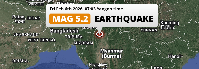
Under land 35 miles from Mawlaik in Myanmar, a shallow and significant M5.2 earthquake occurred in the morning of Friday February 6th, 2026. Other countries near the epicenter include India and China.
Felt the earthquake? Share this article: 


Earthquake Summary
The earthquake struck on land in Myanmar, 35 miles (57 km) east-southeast of Mawlaik in Sagain. The center of this earthquake had a very shallow depth of 6 km. Shallow earthquakes usually have a larger impact than earthquakes deep in the earth.
| Date and Time: | Feb 6, 2026 07:03AM (Yangon Time) - Feb 6, 2026 00:33 Universal Time. |
|---|---|
| Location: | 35 mi ESE of Mawlaik, Sagain, Myanmar. Coordinates 23°30'40"N 94°56'52"E. |
| Map: | 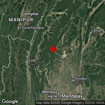 Map of area around epicenter. Click to open in Google Maps. |
| Magnitude: | MAG 5.2 Detected by 72 stations. Maximum Error Range ±0.067 . |
| Depth: | 6 mi (10 km) A very shallow depth. |
| Tsunami Risk: | Tsunami very unlikely While this was a shallow earthquake, it appears to have occurred under land with a magnitude not strong enough to cause tsunami's. Always stay cautious - More info here. |
Nearby towns and cities
Myanmar , India and China are all located within 300km distance of the epicenter of the earthquake.
The closest significant population center near the earthquake is Mawlaik in Sagain, Myanmar. Mawlaik is located 35 miles (57 km) east-southeast of the epicenter.
Major cities near this earthquake: Mandalay is located 129 mi to the south-east. Imphāl is located 177 km to the northwest. Aizawl is located 228 km to the west.
The table below provides an overview of all places in proximity of today's earthquake.
Overview of nearby places
| Distance | Place |
|---|---|
| 35 mi (57 km) WNW from epicenter |
Mawlaik Sagain, Myanmar. |
| 81 mi (130 km) SE from epicenter |
Shwebo Sagain, Myanmar. |
| 147 km (91 mi) NW from epicenter |
Kakching Manipur, India. |
| 98 mi (157 km) S from epicenter |
Monywa Sagain, Myanmar. |
| 158 km (98 mi) NW from epicenter |
Thoubāl Manipur, India. |
| 159 km (99 mi) NW from epicenter |
Churāchāndpur Manipur, India. |
| 162 km (101 mi) NW from epicenter |
Moirāng Manipur, India. |
| 163 km (101 mi) NW from epicenter |
Mayāng Imphāl Manipur, India. |
| 104 mi (167 km) SW from epicenter |
Hakha Chin, Myanmar. |
| 107 mi (173 km) ESE from epicenter |
Mogok Mandalay, Myanmar. |
| 177 km (110 mi) NW from epicenter |
Imphāl Manipur, India. |
| 129 mi (207 km) SE from epicenter |
Mandalay Mandalay, Myanmar. |
| 130 mi (210 km) SSE from epicenter |
Sagaing Sagain, Myanmar. |
| 216 km (134 mi) W from epicenter |
Serchhīp Mizoram, India. |
| 140 mi (226 km) SE from epicenter |
Pyin Oo Lwin Mandalay, Myanmar. |
| 228 km (142 mi) W from epicenter |
Aizawl Mizoram, India. |
| 231 km (144 mi) WSW from epicenter |
Saiha Mizoram, India. |
| 145 mi (233 km) SSE from epicenter |
Myingyan Mandalay, Myanmar. |
| 236 km (147 mi) WSW from epicenter |
Lunglei Mizoram, India. |
| 150 mi (242 km) S from epicenter |
Pakokku Magway, Myanmar. |
| 244 km (152 mi) WNW from epicenter |
Kolasib Mizoram, India. |
| 152 mi (244 km) SSE from epicenter |
Kyaukse Mandalay, Myanmar. |
| 244 km (152 mi) N from epicenter |
Phek Manipur, India. |
| 153 mi (247 km) ENE from epicenter |
Bhamo Kachin, Myanmar. |
| 255 km (158 mi) NNW from epicenter |
Kohīma Nagaland, India. |
| 263 km (163 mi) WNW from epicenter |
Silchar Assam, India. |
| 268 km (167 mi) NW from epicenter |
Hāflong Assam, India. |
| 275 km (171 mi) WNW from epicenter |
Hailākāndi Assam, India. |
| 277 km (172 mi) N from epicenter |
Zunheboto Nagaland, India. |
| 181 mi (291 km) S from epicenter |
Chauk Magway, Myanmar. |
| 182 mi (293 km) ESE from epicenter |
Lashio Shan, Myanmar. |
| 294 km (183 mi) NNW from epicenter |
Dimāpur Nagaland, India. |
| 296 km (184 mi) NNW from epicenter |
Wokha Nagaland, India. |
| 298 km (185 mi) WNW from epicenter |
Dharmanagar Tripura, India. |
| 300 km (186 mi) ENE from epicenter |
Zhangfeng Yunnan, China. |
Risk of aftershocks?
This earthquake did not have any significant foreshocks nor aftershocks occurring within 100km (62 mi) of its epicenter.
The risk of aftershocks decreases rapidly over time. Usually, aftershocks are at least one order of magnitude lower than a main shock.
It's always adviced to be cautious of the risk of a larger shock following any significant earthquake, however this risk is fairly small. There is a roughly 94 percent change that no larger main shock will follow in the days following this earthquake.
Read: How to Stay Safe during an Earthquake (cdc.gov).Earthquakes like this happen often in the region
Earthquakes of this strength are very common in the region. This is the strongest earthquake to hit since August 22nd, 2025, when a 5.3 magnitude earthquake hit 44 mi (71 km) further west. An even stronger magnitude 7.7 earthquake struck on March 28th, 2025.
In total, 20 earthquakes with a magnitude of 5.2 or higher have been registered within 300km (186 mi) of this epicenter in the past 10 years. This comes down to an average of once every 6 months.
Tsunami very unlikely
While MAG-6.5+ earthquakes may cause tsunami's, it appears that the epicenter of this earthquake hit under land. In addition, the reported depth is deeper than 100km, making the risk of a tsunami even less likely. However always stay cautious and monitor advice from local authorities.
Tsunami Risk Factors
| Factor | Under Sea? | MAG-6.5 or stronger? | Shallow depth? |
|---|---|---|---|
| Explanation | Almost all tsunami's are caused by earthquakes with their epicenter under sea or very near the sea. However stay cautious in coastal areas as earthquakes on land may cause landslides into sea, potentially still causing a local tsunami. | Under MAG 6.5: Very unlikely to cause a tsunami. MAG 6.5 to 7.5: Destructive tsunami's do occur, but are uncommon. Likely to observe small sea level changes. MAG 7.6+: Earthquakes with these magnitudes might produce destructive tsunami's. |
Most destructive tsunami's are caused by shallow earthquakes with a depth between 0 and 100km under the surface of the earth. Deeper tsunami's are unlikely to displace to ocean floor. |
| This Earthquake | Not this earthquake. This earthquake appears to have struck on land far from any coast. |
Not this earthquake. This earthquake had a magnitude of 5.2. Earthquakes of this strength are unlikely to trigger a tsunami. |
This earthquake occurred at a depth of of 6 mi (10 km). Earthquakes this shallow could trigger a tsunami. |
Sources
Last updated 18/02/26 00:48 (). As more information on this earthquake becomes available this article will be updated. This article is automatically composed based on data originating from multiple sources.
- US Geographic Society (USGS): Earthquake us6000s6ug
- European-Mediterranean Seismological Centre (EMSC): Earthquake 20260206_0000013
- Geonames.org: World Cities Database
- Google Maps: Static API
- Earthquakelist.org: Historic Earthquakes Database
Share this article:
