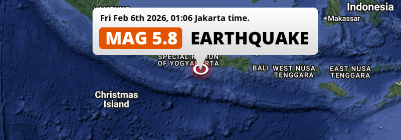
In the Indian Ocean 151 kilometer from Yogyakarta, Indonesia, a significant MAG-5.8 earthquake occurred in the night of Friday February 6th, 2026. Shaking may have been felt by a total of 53 million people.
Felt the earthquake? Share this article: 


Earthquake Summary
This earthquake hit under water in the Indian Ocean, 66 kilometers (41 mi) off the coast of Indonesia, 151 kilometer south-east of Yogyakarta. The center of this earthquake had a quite shallow depth of 40 km. Shallow earthquakes usually have a larger impact than earthquakes deep in the earth.
| Date and Time: | Feb 6, 2026 01:06 (Jakarta Time) - Feb 5, 2026 18:06 Universal Time. |
|---|---|
| Location: | 151 km SE of Yogyakarta, Indonesia. Coordinates 8°51'38"S 111°13'14"E. |
| Map: | 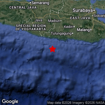 Map of area around epicenter. Click to open in Google Maps. |
| Magnitude: | MAG 5.8 Detected by 34 stations. Maximum Error Range ±0.053 . |
| Depth: | 40 km (25 mi) A quite shallow depth. |
| Max. Intensity: | V
Moderate On the Modified Mercalli Scale. |
| Tsunami Risk: | Low tsunami risk Earthquakes under MAG-6.5 do not usually cause tsunami's. Always stay cautious - More info here. |
Minimal impact predicted
The US Geographic Survey (USGS) describes the impact of this earthquake as follows:
One person killed at Ngadirojo and at least 60 buildings damaged in Jawa Timur. At least 47 people injured and 20 buildings damaged in Yogyakarta. Six buildings damaged in Jawa Tengah.
Based on scientific estimates by the USGS, the risk of high fatalities for this earthquake is classified at level GREEN (low). They expect an 65% likelyhood of between 0 and 1 fatalities, and a 96% chance that the number of fatalities falls no higher than 10.
The USGS classifies the economic impact of this earthquake at level GREEN (low). They expect an 65% likelyhood of between 0 and 1 million US Dollars in economic damage and impact, and a 96% chance that the economic impact of this earthquake falls no higher than 10 million USD.
Roughly 53 million people exposed to shaking
An estimated 53 million have been exposed to shaking (An MMI or Modified Mercalli Intensity level II or higher) as a result of this earthquake according scientific estimates published by the USGS.
An estimated 7,643,000 people were exposed to level IV. At this level, light shaking and likely no damage can be expected. The majority of people (roughly 45 million) live in an area exposed to level III, where weak shaking and probably no damage is expected. All exposure to shaking was within the borders of Indonesia .
| People | MMI Level | Shaking | Damage |
|---|---|---|---|
| 0 | I |
Not noticable | None |
| 476,200 | II |
Very weak | None |
| 44,560,000 | III |
Weak | Probably none |
| 7,643,000 | IV |
Light | Likely none |
| 0 | V |
Moderate | Very light |
| 0 | VI |
Strong | Light |
| 0 | VII |
Very Strong | Moderate |
| 0 | VIII |
Severe | Moderate to heavy |
| 0 | IX |
Violent | Heavy |
| 0 | X |
Extreme | Very heavy |
Nearby towns and cities
This earthquake may have been felt in Indonesia . Trenggalek in East Java, Indonesia is the nearest significant place from the epicenter. The earthquake occurred 102 kilometer (63 mi) southwest of Trenggalek. The intensity of shaking and damage in Trenggalek is estimated to be around level IV on the Modified Mercalli Intensity scale (light shaking, likely no damage).
Multiple large cities are in proximity of today's earthquake. Surabaya is located 246 km to the north-east and experienced an intensity of III (weak shaking, probably no damage). Semarang is located 226 km to the northwest (intensity unknown, possibly low). Yogyakarta is located 151 km to the northwest and experienced an intensity of III (weak shaking, probably no damage).
An overview of nearby towns and cities is available in the overview below. If places don't have intensity data available, it likely means the experienced impact in those places was fairly small.
Overview of nearby places
| Distance | Place | Intensity (MMI) |
|---|---|---|
| 102 km (63 mi) NE from epicenter |
Trenggalek East Java, Indonesia. |
IV
Light |
| 109 km (68 mi) N from epicenter |
Jatiroto Central Java, Indonesia. |
IV
Light |
| 111 km (69 mi) NE from epicenter |
Boyolangu East Java, Indonesia. |
IV
Light |
| 113 km (70 mi) N from epicenter |
Ponorogo East Java, Indonesia. |
IV
Light |
| 116 km (72 mi) NE from epicenter |
Tulungagung East Java, Indonesia. |
IV
Light |
| 117 km (73 mi) NE from epicenter |
Kedungwaru East Java, Indonesia. |
IV
Light |
| 121 km (75 mi) NE from epicenter |
Ngunut East Java, Indonesia. |
IV
Light |
| 126 km (78 mi) N from epicenter |
Selogiri Central Java, Indonesia. |
IV
Light |
| 134 km (83 mi) NE from epicenter |
Blitar East Java, Indonesia. |
III
Weak |
| 141 km (88 mi) N from epicenter |
Madiun East Java, Indonesia. |
IV
Light |
| 143 km (89 mi) NW from epicenter |
Wedi Central Java, Indonesia. |
III
Weak |
| 144 km (89 mi) NW from epicenter |
Bambanglipuro Yogyakarta, Indonesia. |
III
Weak |
| 145 km (90 mi) NE from epicenter |
Kediri East Java, Indonesia. |
IV
Light |
| 145 km (90 mi) NW from epicenter |
Sewon Yogyakarta, Indonesia. |
IV
Light |
| 145 km (90 mi) NW from epicenter |
Klaten Central Java, Indonesia. |
III
Weak |
| 146 km (91 mi) NW from epicenter |
Bantul Yogyakarta, Indonesia. |
IV
Light |
| 147 km (91 mi) NW from epicenter |
Pandak Yogyakarta, Indonesia. |
IV
Light |
| 147 km (91 mi) N from epicenter |
Grogol Central Java, Indonesia. |
IV
Light |
| 147 km (91 mi) NW from epicenter |
Candi Prambanan Central Java, Indonesia. |
III
Weak |
| 147 km (91 mi) N from epicenter |
Baki Central Java, Indonesia. |
IV
Light |
| 150 km (93 mi) NE from epicenter |
Gampengrejo East Java, Indonesia. |
IV
Light |
| 150 km (93 mi) NW from epicenter |
Karanganom Central Java, Indonesia. |
III
Weak |
| 150 km (93 mi) NW from epicenter |
Depok Yogyakarta, Indonesia. |
III
Weak |
| 151 km (94 mi) N from epicenter |
Surakarta Central Java, Indonesia. |
IV
Light |
| 151 km (94 mi) NW from epicenter |
Yogyakarta Yogyakarta, Indonesia. |
III
Weak |
| 151 km (94 mi) NW from epicenter |
Kasihan Yogyakarta, Indonesia. |
IV
Light |
| 152 km (94 mi) N from epicenter |
Gatak Central Java, Indonesia. |
III
Weak |
| 154 km (96 mi) NW from epicenter |
Gamping Lor Yogyakarta, Indonesia. |
III
Weak |
| 155 km (96 mi) N from epicenter |
Kartasura Central Java, Indonesia. |
III
Weak |
| 157 km (98 mi) NW from epicenter |
Melati Yogyakarta, Indonesia. |
III
Weak |
| 158 km (98 mi) NW from epicenter |
Godean Yogyakarta, Indonesia. |
III
Weak |
| 159 km (99 mi) NE from epicenter |
Nganjuk East Java, Indonesia. |
IV
Light |
| 159 km (99 mi) NW from epicenter |
Sleman Yogyakarta, Indonesia. |
III
Weak |
| 161 km (100 mi) N from epicenter |
Sragen Central Java, Indonesia. |
III
Weak |
| 162 km (101 mi) NE from epicenter |
Pare East Java, Indonesia. |
III
Weak |
| 163 km (101 mi) NW from epicenter |
Boyolali Central Java, Indonesia. |
III
Weak |
| 169 km (105 mi) NE from epicenter |
Kepanjen East Java, Indonesia. |
III
Weak |
| 172 km (107 mi) NE from epicenter |
Kertosono East Java, Indonesia. |
III
Weak |
| 181 km (112 mi) NE from epicenter |
Batu East Java, Indonesia. |
III
Weak |
| 183 km (114 mi) NE from epicenter |
Malang East Java, Indonesia. |
III
Weak |
| 184 km (114 mi) NE from epicenter |
Jombang East Java, Indonesia. |
III
Weak |
| 185 km (115 mi) NW from epicenter |
Mertoyudan Central Java, Indonesia. |
III
Weak |
| 188 km (117 mi) NW from epicenter |
Salatiga Central Java, Indonesia. |
III
Weak |
| 190 km (118 mi) NW from epicenter |
Magelang Central Java, Indonesia. |
III
Weak |
| 192 km (119 mi) NE from epicenter |
Singosari East Java, Indonesia. |
III
Weak |
| 198 km (123 mi) NE from epicenter |
Lawang East Java, Indonesia. |
III
Weak |
| 199 km (124 mi) NW from epicenter |
Ambarawa Central Java, Indonesia. |
III
Weak |
| 200 km (124 mi) N from epicenter |
Purwodadi Central Java, Indonesia. |
III
Weak |
| 226 km (140 mi) NW from epicenter |
Semarang Central Java, Indonesia. |
|
| 246 km (153 mi) NE from epicenter |
Surabaya East Java, Indonesia. |
III
Weak |
| 283 km (176 mi) E from epicenter |
Jember East Java, Indonesia. |
|
| 372 km (231 mi) NW from epicenter |
Tasikmalaya West Java, Indonesia. |
|
| 378 km (235 mi) E from epicenter |
Negara Bali, Indonesia. |
Earthquake Intensity Map
The intensity in shaking and damage by this earthquake is illustrated through the map below. The highest intensity measured for this earthquake is IV.

Shaking reported by 29 people
People that feel an earthquake may report their experience to the US Geographic Survey. Currently, 29 people have reported shaking in 21 places, all within Indonesia.We keep updating this article as more ground reports become available. You may report that you felt this earthquake here.
Places with most reports:
- Sewon, Yogyakarta, Indonesia: 4 people.
- Yogyakarta, Yogyakarta, Indonesia: 3 people.
- Depok, Yogyakarta, Indonesia: 2 people.
- Magelang, Jawa Tengah, Indonesia: 2 people.
- Prambanan, Jawa Tengah, Indonesia: 2 people.
- Pundong, Yogyakarta, Indonesia: 1 person.
- Driyorejo, Jawa Timur, Indonesia: 1 person.
- Pondok Aren, Banten, Indonesia: 1 person.
- Karawang, Jawa Barat, Indonesia: 1 person.
- Bandung, Jawa Barat, Indonesia: 1 person.
27 Aftershocks detected
Since this main shock, 27 smaller aftershocks were detected. At a distance of 6 km (3 mi) west of this earthquake, an aftershock struck 4 mins later. It measured a magnitude of 4
In the days before this main shock, 12 smaller foreshocks were detected. Nearby this earthquake a foreshock struck 2 days earlier. It measured a magnitude of 3.2
Overview of foreshocks and aftershocks
| Classification | Magnitude | When | Where |
|---|---|---|---|
| Foreshock | M 2.5 |
3 days earlier Feb 3, 2026 01:36 (Jakarta Time) | 12 km (7 mi) W from Main Shock. |
| Foreshock | M 2.5 |
3 days earlier Feb 3, 2026 05:46 (Jakarta Time) | 35 km (22 mi) E from Main Shock. |
| Foreshock | M 2.6 |
2 days earlier Feb 3, 2026 14:29 (Jakarta Time) | 7 km (4 mi) S from Main Shock. |
| Foreshock | M 2.5 |
2 days earlier Feb 3, 2026 14:35 (Jakarta Time) | 99 km (62 mi) W from Main Shock. |
| Foreshock | M 2.5 |
2 days earlier Feb 3, 2026 19:54 (Jakarta Time) | 20 km (13 mi) NW from Main Shock. |
| Foreshock | M 2.6 |
2 days earlier Feb 3, 2026 20:25 (Jakarta Time) | 29 km (18 mi) W from Main Shock. |
| Foreshock | M 2.5 |
2 days earlier Feb 3, 2026 21:57 (Jakarta Time) | 99 km (62 mi) W from Main Shock. |
| Foreshock | M 2.5 |
2 days earlier Feb 4, 2026 02:17 (Jakarta Time) | 95 km (59 mi) W from Main Shock. |
| Foreshock | M 2.5 |
2 days earlier Feb 4, 2026 02:37 (Jakarta Time) | 41 km (26 mi) E from Main Shock. |
| Foreshock | M 2.7 |
2 days earlier Feb 4, 2026 03:42 (Jakarta Time) | 98 km (61 mi) W from Main Shock. |
| Foreshock | M 3.2 |
2 days earlier Feb 4, 2026 07:01 (Jakarta Time) | 12 km (8 mi) N from Main Shock. |
| Foreshock | M 2.5 |
4 hrs earlier Feb 5, 2026 21:29 (Jakarta Time) | 32 km (20 mi) W from Main Shock. |
| Main Shock This Earthquake |
M 5.8 |
Feb 6, 2026 01:06 (Jakarta Time) | - |
| Aftershock | M 4.0 |
4 mins later Feb 6, 2026 01:10 (Jakarta Time) | 6 km (3 mi) W from Main Shock. |
| Aftershock | M 3.7 |
5 mins later Feb 6, 2026 01:11 (Jakarta Time) | 4 km (2.2 mi) N from Main Shock. |
| Aftershock | M 2.8 |
10 mins later Feb 6, 2026 01:16 (Jakarta Time) | 8 km (5 mi) SW from Main Shock. |
| Aftershock | M 2.5 |
7 hrs later Feb 6, 2026 08:03 (Jakarta Time) | 12 km (8 mi) SW from Main Shock. |
| Aftershock | M 2.5 |
9 hrs later Feb 6, 2026 10:26 (Jakarta Time) | 9 km (5 mi) W from Main Shock. |
| Aftershock | M 2.5 |
17 hrs later Feb 6, 2026 18:19 (Jakarta Time) | 11 km (7 mi) W from Main Shock. |
| Aftershock | M 2.7 |
19 hrs later Feb 6, 2026 19:49 (Jakarta Time) | 89 km (55 mi) N from Main Shock. |
| Aftershock | M 2.7 |
19 hrs later Feb 6, 2026 20:17 (Jakarta Time) | 30 km (19 mi) S from Main Shock. |
| Aftershock | M 2.6 |
21 hrs later Feb 6, 2026 22:22 (Jakarta Time) | 5 km (3 mi) SW from Main Shock. |
| Aftershock | M 2.6 |
23 hrs later Feb 6, 2026 23:54 (Jakarta Time) | 9 km (6 mi) SW from Main Shock. |
| Aftershock | M 2.5 |
1 day later Feb 7, 2026 02:34 (Jakarta Time) | 7 km (4 mi) W from Main Shock. |
| Aftershock | M 2.5 |
1 day later Feb 7, 2026 02:41 (Jakarta Time) | 23 km (14 mi) W from Main Shock. |
| Aftershock | M 2.5 |
1 day later Feb 7, 2026 07:30 (Jakarta Time) | 70 km (43 mi) E from Main Shock. |
| Aftershock | M 2.5 |
1 day later Feb 7, 2026 07:46 (Jakarta Time) | 7 km (5 mi) SW from Main Shock. |
| Aftershock | M 2.6 |
1 day later Feb 7, 2026 09:12 (Jakarta Time) | 100 km (62 mi) W from Main Shock. |
| Aftershock | M 2.6 |
1 day later Feb 7, 2026 09:17 (Jakarta Time) | 9 km (5 mi) NW from Main Shock. |
| Aftershock | M 2.5 |
1 day later Feb 7, 2026 09:49 (Jakarta Time) | 9 km (6 mi) NW from Main Shock. |
| Aftershock | M 2.6 |
1 day later Feb 7, 2026 11:08 (Jakarta Time) | 59 km (37 mi) E from Main Shock. |
| Aftershock | M 2.6 |
2 days later Feb 7, 2026 14:33 (Jakarta Time) | 13 km (8 mi) SE from Main Shock. |
| Aftershock | M 2.6 |
2 days later Feb 7, 2026 22:33 (Jakarta Time) | 7 km (4 mi) W from Main Shock. |
| Aftershock | M 2.5 |
2 days later Feb 8, 2026 02:13 (Jakarta Time) | 16 km (10 mi) NE from Main Shock. |
| Aftershock | M 2.6 |
2 days later Feb 8, 2026 04:03 (Jakarta Time) | 9 km (6 mi) W from Main Shock. |
| Aftershock | M 2.6 |
2 days later Feb 8, 2026 07:38 (Jakarta Time) | 11 km (7 mi) SW from Main Shock. |
| Aftershock | M 2.9 |
2 days later Feb 8, 2026 11:05 (Jakarta Time) | 36 km (22 mi) SE from Main Shock. |
| Aftershock | M 2.7 |
3 days later Feb 8, 2026 17:26 (Jakarta Time) | 10 km (6 mi) S from Main Shock. |
| Aftershock | M 2.5 |
3 days later Feb 8, 2026 22:33 (Jakarta Time) | 2.4 km (1.5 mi) SE from Main Shock. |
| Aftershock | M 3.1 |
3 days later Feb 8, 2026 23:43 (Jakarta Time) | 97 km (60 mi) W from Main Shock. |
More earthquakes coming?
Aftershocks are usually at least 1 order of magnitude less strong than main shocks. The more time passes, the smaller the chance and likely strength of any potential aftershocks.
The chance that a significant earthquake like this one is followed by an even larger earthquake is not so large. On average, scientists estimate a 94% chance that a major earthquake will not be followed by an even larger one. It is still adviced to be aware of this risk
Read: How to Stay Safe during an Earthquake (cdc.gov).This is the strongest earthquake in 3 years
Earthquakes of this strength occur quite regularly in the region. This is the strongest earthquake to hit since June 30th, 2023, when a 5.9 magnitude earthquake hit 134 km (83 mi) further west. An even stronger magnitude 6 earthquake struck on April 10th, 2021.
In total, 3 earthquakes with a magnitude of 5.8 or higher have been registered within 300km (186 mi) of this epicenter in the past 10 years. This comes down to an average of once every 3 years.
Low tsunami risk
Based on early data it appears this earthquake was not strong enough (lower than MAG-6.5) to be likely to cause destructive tsunami's. However this earthquake appeared to have hit at a shallow depth under sea, so stay cautious and monitor advice from local authorities.
Tsunami Risk Factors
| Factor | Under Sea? | MAG-6.5 or stronger? | Shallow depth? |
|---|---|---|---|
| Explanation | Almost all tsunami's are caused by earthquakes with their epicenter under sea or very near the sea. However stay cautious in coastal areas as earthquakes on land may cause landslides into sea, potentially still causing a local tsunami. | Under MAG 6.5: Very unlikely to cause a tsunami. MAG 6.5 to 7.5: Destructive tsunami's do occur, but are uncommon. Likely to observe small sea level changes. MAG 7.6+: Earthquakes with these magnitudes might produce destructive tsunami's. |
Most destructive tsunami's are caused by shallow earthquakes with a depth between 0 and 100km under the surface of the earth. Deeper tsunami's are unlikely to displace to ocean floor. |
| This Earthquake | This earthquake appears to have struck under the sea. | Not this earthquake. This earthquake had a magnitude of 5.8. Earthquakes of this strength are unlikely to trigger a tsunami. |
This earthquake occurred at a depth of of 40 km (25 mi). Earthquakes this shallow could trigger a tsunami. |
Sources
Last updated 06/04/26 02:28 (). This article is automatically generated based on available data. We keep checking multiple sources for additional information. This article gets updated as new details on this earthquake become available.
- US Geographic Society (USGS): Earthquake us6000s6ne
- European-Mediterranean Seismological Centre (EMSC): Earthquake 20260205_0000270
- Geonames.org: World Cities Database
- Google Maps: Static API
- Earthquakelist.org: Historic Earthquakes Database
Share this article:
