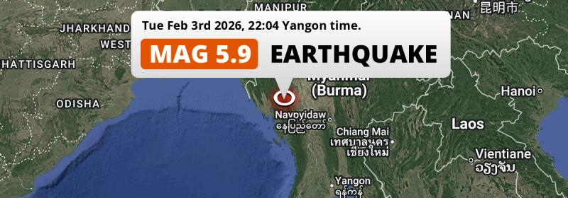
Under land 60 miles from Yenangyaung in Myanmar, a significant MAG-5.8 earthquake occurred in the evening of Tuesday February 3rd, 2026. Roughly 16 million people may have felt this earthquake. Other nearby countries are Bangladesh and India.
Felt the earthquake? Share this article: 


Earthquake Summary
The earthquake struck on land in Myanmar, 60 miles (96 km) west of Yenangyaung in Magway. The center of this earthquake had a quite shallow depth of 37 km. Shallow earthquakes usually have a larger impact than earthquakes deep in the earth.
| Date and Time: | Feb 3, 2026 10:04PM (Yangon Time) - Feb 3, 2026 15:34 Universal Time. |
|---|---|
| Location: | 60 mi west of Yenangyaung, Magway, Myanmar. Coordinates 20°26'12"N 93°56'48"E. |
| Map: | 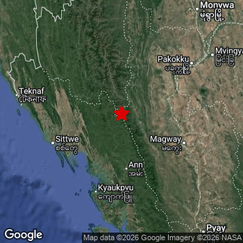 Map of area around epicenter. Click to open in Google Maps. |
| Magnitude: | MAG 5.8 Detected by 20 stations. Maximum Error Range ±0.069 . |
| Depth: | 37 mi (59 km) A quite shallow depth. |
| Max. Intensity: | V
Moderate On the Modified Mercalli Scale. |
| Tsunami Risk: | Tsunami very unlikely While this was a shallow earthquake, it appears to have occurred under land with a magnitude not strong enough to cause tsunami's. Always stay cautious - More info here. |
Minimal impact predicted
Based on scientific estimates by the US Geographic Survey (USGS), the risk of high fatalities for this earthquake is classified at level GREEN (low). They expect an 65% likelyhood of between 0 and 1 fatalities, and a 96% chance that the number of fatalities falls no higher than 10.
The USGS classifies the economic impact of this earthquake at level GREEN (low). They expect an 65% likelyhood of between 0 and 1 million US Dollars in economic damage and impact, and a 96% chance that the economic impact of this earthquake falls no higher than 10 million USD.
Roughly 16 million people exposed to shaking
The USGS has published a report estimating the number of people exposed to this earthquake. Acoording to their analysis, roughly 16 million have been exposed to shaking at an MMI level of II or higher.
An estimated 4,415,000 people were exposed to level IV. At this level, light shaking and likely no damage can be expected. Intensity level III was experienced by the majority of people (around 11 million). In their region, weak shaking and probably no damage can be expected.
People in 3 countries have been exposed to shaking. In Myanmar , around 11 million people, with impact levels up to IV (light shaking, likely no damage). In Bangladesh , around 4.3 million people. Shaking was experienced by inhabitants of India too.
| People | MMI Level | Shaking | Damage |
|---|---|---|---|
| 0 | I |
Not noticable | None |
| 48,770 | II |
Very weak | None |
| 11,070,000 | III |
Weak | Probably none |
| 4,415,000 | IV |
Light | Likely none |
| 0 | V |
Moderate | Very light |
| 0 | VI |
Strong | Light |
| 0 | VII |
Very Strong | Moderate |
| 0 | VIII |
Severe | Moderate to heavy |
| 0 | IX |
Violent | Heavy |
| 0 | X |
Extreme | Very heavy |
Nearby towns and cities
Myanmar , Bangladesh and India are all located within 300km distance of the epicenter of the earthquake.
Yenangyaung in Magway, Myanmar is the nearest significant place from the epicenter. The earthquake occurred 60 miles (96 km) west of Yenangyaung. The intensity of shaking and damage in Yenangyaung is estimated to be around level IV on the Modified Mercalli Intensity scale (light shaking, likely no damage).
Major cities near this earthquake: Chattogram is located 304 km to the northwest (intensity unknown, possibly low). Mandalay is located 174 mi to the north-east (intensity unknown, possibly low). Nay Pyi Taw is located 150 mi to the east (intensity unknown, possibly low).
An overview of nearby towns and cities is available in the overview below. If places don't have intensity data available, it likely means the experienced impact in those places was fairly small.
Overview of nearby places
| Distance | Place | Intensity (MMI) |
|---|---|---|
| 60 mi (96 km) E from epicenter |
Yenangyaung Magway, Myanmar. |
IV
Light |
| 63 mi (101 km) E from epicenter |
Minbu Magway, Myanmar. |
IV
Light |
| 65 mi (104 km) NE from epicenter |
Chauk Magway, Myanmar. |
IV
Light |
| 67 mi (108 km) E from epicenter |
Magway Magway, Myanmar. |
IV
Light |
| 71 mi (114 km) W from epicenter |
Sittwe Rakhine, Myanmar. |
IV
Light |
| 96 mi (155 km) NE from epicenter |
Pakokku Magway, Myanmar. |
III
Weak |
| 108 mi (174 km) E from epicenter |
Taungdwingyi Magway, Myanmar. |
III
Weak |
| 111 mi (178 km) SE from epicenter |
Myaydo Magway, Myanmar. |
III
Weak |
| 178 km (111 mi) W from epicenter |
Teknāf Chittagong, Bangladesh. |
III
Weak |
| 111 mi (179 km) SE from epicenter |
Thayetmyo Magway, Myanmar. |
III
Weak |
| 117 mi (188 km) NE from epicenter |
Myingyan Mandalay, Myanmar. |
III
Weak |
| 127 mi (205 km) E from epicenter |
Meiktila Mandalay, Myanmar. |
III
Weak |
| 139 mi (223 km) NE from epicenter |
Monywa Sagain, Myanmar. |
III
Weak |
| 139 mi (224 km) SE from epicenter |
Pyay Bago, Myanmar. |
III
Weak |
| 142 mi (228 km) E from epicenter |
Yamethin Mandalay, Myanmar. |
|
| 230 km (143 mi) NW from epicenter |
Cox’s Bāzār Chittagong, Bangladesh. |
|
| 150 mi (241 km) E from epicenter |
Nay Pyi Taw Nay Pyi Taw, Myanmar. |
|
| 154 mi (248 km) N from epicenter |
Hakha Chin, Myanmar. |
|
| 249 km (155 mi) NW from epicenter |
Saiha Mizoram, India. |
|
| 155 mi (249 km) E from epicenter |
Pyinmana Nay Pyi Taw, Myanmar. |
|
| 163 mi (262 km) NE from epicenter |
Kyaukse Mandalay, Myanmar. |
|
| 265 km (165 mi) NW from epicenter |
Bāndarban Chittagong, Bangladesh. |
II
Weak |
| 165 mi (265 km) NE from epicenter |
Sagaing Sagain, Myanmar. |
|
| 268 km (167 mi) NW from epicenter |
Sātkania Chittagong, Bangladesh. |
|
| 168 mi (271 km) SE from epicenter |
Paungde Bago, Myanmar. |
|
| 173 mi (279 km) SE from epicenter |
Myanaung Ayeyarwady, Myanmar. |
|
| 174 mi (280 km) NE from epicenter |
Mandalay Mandalay, Myanmar. |
|
| 290 km (180 mi) NW from epicenter |
Patiya Chittagong, Bangladesh. |
|
| 185 mi (298 km) NE from epicenter |
Shwebo Sagain, Myanmar. |
|
| 300 km (186 mi) NW from epicenter |
Lunglei Mizoram, India. |
|
| 304 km (189 mi) NW from epicenter |
Chattogram Chittagong, Bangladesh. |
|
| 192 mi (309 km) SE from epicenter |
Taungoo Bago, Myanmar. |
|
| 314 km (195 mi) NW from epicenter |
Raojān Chittagong, Bangladesh. |
|
| 196 mi (315 km) NE from epicenter |
Pyin Oo Lwin Mandalay, Myanmar. |
|
| 201 mi (324 km) E from epicenter |
Taunggyi Shan, Myanmar. |
|
| 335 km (208 mi) NW from epicenter |
Bibir Hat Chittagong, Bangladesh. |
|
| 337 km (209 mi) N from epicenter |
Serchhīp Mizoram, India. |
|
| 211 mi (340 km) SE from epicenter |
Pyu Bago, Myanmar. |
|
| 345 km (214 mi) NW from epicenter |
Manikchari Chittagong, Bangladesh. |
|
| 346 km (215 mi) NW from epicenter |
Sandwīp Chittagong, Bangladesh. |
|
| 216 mi (348 km) SE from epicenter |
Hinthada Ayeyarwady, Myanmar. |
|
| 217 mi (350 km) SE from epicenter |
Letpandan Bago, Myanmar. |
|
| 218 mi (351 km) E from epicenter |
Loikaw Kayah, Myanmar. |
|
| 224 mi (360 km) N from epicenter |
Mawlaik Sagain, Myanmar. |
|
| 360 km (224 mi) NW from epicenter |
Khagrachhari Chittagong, Bangladesh. |
|
| 227 mi (365 km) SE from epicenter |
Tharyarwady Bago, Myanmar. |
|
| 382 km (237 mi) NW from epicenter |
Chhāgalnāiya Chittagong, Bangladesh. |
|
| 237 mi (382 km) NE from epicenter |
Mogok Mandalay, Myanmar. |
|
| 387 km (240 mi) N from epicenter |
Aizawl Mizoram, India. |
|
| 389 km (242 mi) NW from epicenter |
Feni Chittagong, Bangladesh. |
|
| 390 km (242 mi) NW from epicenter |
Uttar Char Fasson Khulna, Bangladesh. |
|
| 394 km (245 mi) NW from epicenter |
Lālmohan Barisāl, Bangladesh. |
Earthquake Intensity Map
The intensity in shaking and damage by this earthquake is illustrated through the map below. The highest intensity measured for this earthquake is V.

Shaking reported by 26 people in 3 countries
People that feel an earthquake may report their experience to the US Geographic Survey. Currently, 26 people have reported shaking in 16 places in 3 countries (Bangladesh, Myanmar, India).We keep updating this article as more ground reports become available. You may report that you felt this earthquake here.
Places with most reports:
- Chakdaha, Bangla, India: 5 people.
- Dacca, Dhāka, Bangladesh: 4 people.
- Calcutta, Bangla, India: 2 people.
- Dulia Gaon, Assam, India: 2 people.
- Chattagam, Chāţţagām, Bangladesh: 2 people.
- Co'xs Bazar, Koks Bāzār, Bangladesh: 1 person.
- Sagaing, Sagaing, Myanmar: 1 person.
- Rajpur, Bangla, India: 1 person.
- Basirhat, Bangla, India: 1 person.
- Khardaha, Bangla, India: 1 person.
Aftershocks detected
After this earthquake struck, 1 smaller aftershock occurred. A 5.1 magnitude earthquake hit 17 mins later 9 mi (15 km) north-east of this earthquake.
Overview of foreshocks and aftershocks
| Classification | Magnitude | When | Where |
|---|---|---|---|
| Main Shock This Earthquake |
M 5.8 |
Feb 3, 2026 10:04PM (Yangon Time) | - |
| Aftershock | M 5.1 |
17 mins later Feb 3, 2026 10:21PM (Yangon Time) | 9 mi (15 km) NE from Main Shock. |
More earthquakes coming?
Aftershocks are usually at least 1 order of magnitude less strong than main shocks. The more time passes, the smaller the chance and likely strength of any potential aftershocks.
In only six percent of cases, significant earthquakes are followed by a larger main shock, making the current earthquake a foreshock. While the chance of this happening is not so large, it is adviced to maintain cautiousness in the hours and days following a major earthquake.
Read: How to Stay Safe during an Earthquake (cdc.gov).Earthquakes like this are common in the region
Earthquakes of this strength occur quite regularly in the region. This is the strongest earthquake to hit since March 28th, 2025, when a 6.7 magnitude earthquake hit 157 mi (252 km) further north-east. An even stronger magnitude 7.7 earthquake struck on March 28th, 2025.
In total, 5 earthquakes with a magnitude of 5.8 or higher have been registered within 300km (186 mi) of this epicenter in the past 10 years. This comes down to an average of once every 2 years.
Tsunami very unlikely
While MAG-6.5+ earthquakes may cause tsunami's, it appears that the epicenter of this earthquake hit under land. In addition, the reported depth is deeper than 100km, making the risk of a tsunami even less likely. However always stay cautious and monitor advice from local authorities.
Tsunami Risk Factors
| Factor | Under Sea? | MAG-6.5 or stronger? | Shallow depth? |
|---|---|---|---|
| Explanation | Almost all tsunami's are caused by earthquakes with their epicenter under sea or very near the sea. However stay cautious in coastal areas as earthquakes on land may cause landslides into sea, potentially still causing a local tsunami. | Under MAG 6.5: Very unlikely to cause a tsunami. MAG 6.5 to 7.5: Destructive tsunami's do occur, but are uncommon. Likely to observe small sea level changes. MAG 7.6+: Earthquakes with these magnitudes might produce destructive tsunami's. |
Most destructive tsunami's are caused by shallow earthquakes with a depth between 0 and 100km under the surface of the earth. Deeper tsunami's are unlikely to displace to ocean floor. |
| This Earthquake | Not this earthquake. This earthquake appears to have struck on land far from any coast. |
Not this earthquake. This earthquake had a magnitude of 5.8. Earthquakes of this strength are unlikely to trigger a tsunami. |
This earthquake occurred at a depth of of 37 mi (59 km). Earthquakes this shallow could trigger a tsunami. |
Sources
Last updated 04/04/26 05:38 (). This article is automatically generated based on available data. We keep checking multiple sources for additional information. This article gets updated as new details on this earthquake become available.
- US Geographic Society (USGS): Earthquake us6000s65b
- European-Mediterranean Seismological Centre (EMSC): Earthquake 20260203_0000226
- Geonames.org: World Cities Database
- Google Maps: Static API
- Earthquakelist.org: Historic Earthquakes Database
Share this article:
