A shallow and significant Magnitude 5.2 earthquake struck in the South Pacific Ocean 220 kilometer from Apia, Samoa in the morning of Wednesday February 4th, 2026. American Samoa is also near its epicenter.
Felt the earthquake? Share this article: 


Earthquake Summary
This earthquake hit under water in the South Pacific Ocean, 182 kilometers (113 mi) off the coast of Samoa, 220 kilometer southwest of Apia in Tuamasaga. The center of this earthquake had a very shallow depth of 10 km. Shallow earthquakes usually have a larger impact than earthquakes deep in the earth.
| Date and Time: | Feb 4, 2026 08:34 (Apia Time) - Feb 3, 2026 19:34 Universal Time. |
|---|---|
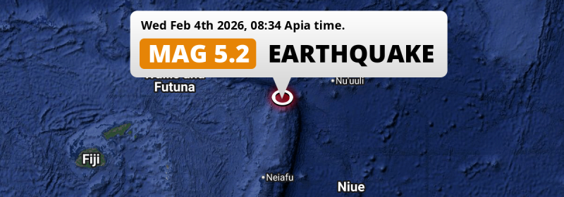
| Location: | 220 km SW of Apia, Tuamasaga, Samoa. Coordinates 15°20'32"S 173°5'11"W. |
| Map: | 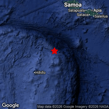 Map of area around epicenter. Click to open in Google Maps. |
| Magnitude: | MAG 5.2 Detected by 248 stations. Maximum Error Range ±0.037 . |
| Depth: | 10 km (6 mi) A very shallow depth. |
| Tsunami Risk: | Low tsunami risk Earthquakes under MAG-6.5 do not usually cause tsunami's. Always stay cautious - More info here. |
Nearby towns and cities
2 countries can be found within 300km of the epicenter of this earthquake: Samoa and American Samoa .
Apia in Tuamasaga, Samoa is the nearest significant place from the epicenter. The earthquake occurred 220 kilometer (137 mi) southwest of Apia.
Overview of nearby places
| Distance | Place |
|---|---|
| 220 km (137 mi) NE from epicenter |
Apia Tuamasaga, Samoa. |
| 282 km (175 mi) ENE from epicenter |
Pago Pago Eastern District, American Samoa. |
Risk of aftershocks?
We have not yet detected any foreshocks or aftershocks (MAG-2.5 or higher) within 100km (62 mi) of this earthquake.
Aftershocks are usually at least 1 order of magnitude less strong than main shocks. The more time passes, the smaller the chance and likely strength of any potential aftershocks.
In only six percent of cases, significant earthquakes are followed by a larger main shock, making the current earthquake a foreshock. While the chance of this happening is not so large, it is adviced to maintain cautiousness in the hours and days following a major earthquake.
Read: How to Stay Safe during an Earthquake (cdc.gov).Earthquakes like this happen often in the region
Earthquakes of this strength are very common in the region. This is the strongest earthquake to hit since January 20th, 2026, when a 5.3 magnitude earthquake hit 63 km (39 mi) further north-east. An even stronger magnitude 7.6 earthquake struck on May 10th, 2023.
In total, 130 earthquakes with a magnitude of 5.2 or higher have been registered within 300km (186 mi) of this epicenter in the past 10 years. This comes down to an average of once every 28 days.
Low tsunami risk
Based on early data it appears this earthquake was not strong enough (lower than MAG-6.5) to be likely to cause destructive tsunami's. However this earthquake appeared to have hit at a shallow depth under sea, so stay cautious and monitor advice from local authorities.
Tsunami Risk Factors
| Factor | Under Sea? | MAG-6.5 or stronger? | Shallow depth? |
|---|---|---|---|
| Explanation | Almost all tsunami's are caused by earthquakes with their epicenter under sea or very near the sea. However stay cautious in coastal areas as earthquakes on land may cause landslides into sea, potentially still causing a local tsunami. | Under MAG 6.5: Very unlikely to cause a tsunami. MAG 6.5 to 7.5: Destructive tsunami's do occur, but are uncommon. Likely to observe small sea level changes. MAG 7.6+: Earthquakes with these magnitudes might produce destructive tsunami's. |
Most destructive tsunami's are caused by shallow earthquakes with a depth between 0 and 100km under the surface of the earth. Deeper tsunami's are unlikely to displace to ocean floor. |
| This Earthquake | This earthquake appears to have struck under the sea. | Not this earthquake. This earthquake had a magnitude of 5.2. Earthquakes of this strength are unlikely to trigger a tsunami. |
This earthquake occurred at a depth of of 10 km (6 mi). Earthquakes this shallow could trigger a tsunami. |
Sources
Last updated 18/02/26 20:58 (). This article contains currently available information about the earthquake and is automatically composed. We continue to update this article up to a few days after the earthquake occurred.
- US Geographic Society (USGS): Earthquake us6000s694
- European-Mediterranean Seismological Centre (EMSC): Earthquake 20260203_0000282
- Geonames.org: World Cities Database
- Google Maps: Static API
- Earthquakelist.org: Historic Earthquakes Database
Share this article:
