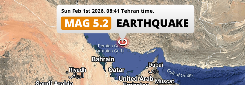
In the morning of Sunday February 1st, 2026, a shallow and significant M5.3 earthquake hit under land 25 kilometer from Mohr in Iran. Qatar, Bahrain and Saudi Arabia are also near its epicenter.
Felt the earthquake? Share this article: 


Earthquake Summary
The earthquake struck on land in Iran, 25 kilometer (16 mi) west-southwest of Mohr in Fars. The center of this earthquake had a very shallow depth of 10 km. Shallow earthquakes usually have a larger impact than earthquakes deep in the earth.
| Date and Time: | Feb 1, 2026 08:41 (Tehran Time) - Feb 1, 2026 05:11 Universal Time. |
|---|---|
| Location: | 25 km WSW of Mohr, Fars, Iran. Coordinates 27°27'1"N 52°39'30"E. |
| Map: | 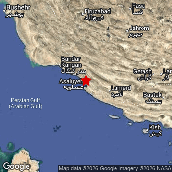 Map of area around epicenter. Click to open in Google Maps. |
| Magnitude: | MAG 5.3 Detected by 26 stations. Maximum Error Range ±0.061 . |
| Depth: | 10 km (6 mi) A very shallow depth. |
| Tsunami Risk: | Low tsunami risk Earthquakes under MAG-6.5 do not usually cause tsunami's. Always stay cautious - More info here. |
Impact
The US Geographic Survey (USGS) describes the impact of this earthquake as follows:
Some homes and structures damaged at Asaluyeh.
Nearby towns and cities
Iran , Qatar , Bahrain and Saudi Arabia are all located within 300km distance of the epicenter of the earthquake.
The closest significant population center near the earthquake is Mohr in Fars, Iran. Mohr is located 25 kilometer (16 mi) west-southwest of the epicenter.
Major cities near this earthquake: Shiraz is located 241 km to the north. Dammam is located 277 km to the west-southwest. Doha is located 266 km to the south-southwest.
The table below provides an overview of all places in proximity of today's earthquake.
Overview of nearby places
| Distance | Place |
|---|---|
| 25 km (16 mi) ENE from epicenter |
Mohr Fars, Iran. |
| 148 km (92 mi) E from epicenter |
Gerāsh Fars, Iran. |
| 155 km (96 mi) N from epicenter |
Fīrūzābād Fars, Iran. |
| 167 km (104 mi) SE from epicenter |
Kīsh Hormozgan, Iran. |
| 192 km (119 mi) NNE from epicenter |
Fasā Fars, Iran. |
| 200 km (124 mi) N from epicenter |
Akbarābād Fars, Iran. |
| 227 km (141 mi) SSW from epicenter |
Al Khawr Al Khor, Qatar. |
| 235 km (146 mi) NE from epicenter |
Dārāb Fars, Iran. |
| 241 km (150 mi) N from epicenter |
Shiraz Fars, Iran. |
| 241 km (150 mi) ESE from epicenter |
Bandar-e Lengeh Hormozgan, Iran. |
| 243 km (151 mi) SW from epicenter |
Al Muharraq Muharraq, Bahrain. |
| 246 km (153 mi) NW from epicenter |
Bushehr Bushehr, Iran. |
| 246 km (153 mi) SW from epicenter |
Manama Manama, Bahrain. |
| 247 km (153 mi) NW from epicenter |
Borāzjān Bushehr, Iran. |
| 248 km (154 mi) SW from epicenter |
Sitrah Manama, Bahrain. |
| 250 km (155 mi) SW from epicenter |
Jidd Ḩafş Manama, Bahrain. |
| 253 km (157 mi) SW from epicenter |
Madīnat ‘Īsá Southern Governorate, Bahrain. |
| 254 km (158 mi) NE from epicenter |
Neyrīz Fars, Iran. |
| 255 km (158 mi) SW from epicenter |
Ar Rifā‘ Southern Governorate, Bahrain. |
| 258 km (160 mi) SSW from epicenter |
Umm Şalāl Muḩammad Baladīyat Umm Şalāl, Qatar. |
| 260 km (162 mi) NNW from epicenter |
Kāzerūn Fars, Iran. |
| 260 km (162 mi) SW from epicenter |
Madīnat Ḩamad Northern Governorate, Bahrain. |
| 263 km (163 mi) SW from epicenter |
Dār Kulayb Southern Governorate, Bahrain. |
| 266 km (165 mi) SSW from epicenter |
Doha Baladīyat ad Dawḩah, Qatar. |
| 270 km (168 mi) N from epicenter |
Marvdasht Fars, Iran. |
| 270 km (168 mi) SSW from epicenter |
Ar Rayyān Baladīyat ar Rayyān, Qatar. |
| 270 km (168 mi) WSW from epicenter |
Raḩīmah Eastern Province, Saudi Arabia. |
| 274 km (170 mi) SSW from epicenter |
Al Wakrah Al Wakrah, Qatar. |
| 276 km (171 mi) WSW from epicenter |
Khobar Eastern Province, Saudi Arabia. |
| 277 km (172 mi) WSW from epicenter |
Tārūt Eastern Province, Saudi Arabia. |
| 277 km (172 mi) WSW from epicenter |
Dammam Eastern Province, Saudi Arabia. |
| 280 km (174 mi) WSW from epicenter |
Sayhāt Eastern Province, Saudi Arabia. |
| 280 km (174 mi) WSW from epicenter |
Al Qaţīf Eastern Province, Saudi Arabia. |
| 282 km (175 mi) WSW from epicenter |
Şafwá Eastern Province, Saudi Arabia. |
| 283 km (176 mi) WSW from epicenter |
Dhahran Eastern Province, Saudi Arabia. |
Shaking reported by 4 people in 2 countries
People that feel an earthquake may report their experience to the US Geographic Survey. Currently, 4 people have reported shaking in 2 places in 2 countries (Iran, Qatar).We keep updating this article as more ground reports become available. You may report that you felt this earthquake here.
Places with most reports:
- Doha, Doha, Qatar: 3 people.
- Kongan, Būshehr, Iran: 1 person.
Aftershocks detected
This main shock was followed by 1 smaller aftershock. Just 2 days after this main shock, an earthquake measuring MAG-3.9 was detected 11 km (7 mi) west-southwest of this earthquake.
Overview of foreshocks and aftershocks
| Classification | Magnitude | When | Where |
|---|---|---|---|
| Main Shock This Earthquake |
M 5.3 |
Feb 1, 2026 08:41 (Tehran Time) | - |
| Aftershock | M 3.9 |
2 days later Feb 3, 2026 01:13 (Tehran Time) | 11 km (7 mi) WSW from Main Shock. |
More earthquakes coming?
Earthquakes can create aftershocks. These are generally at least 1 magnitude lower than any main shock, and as time passes the chance and strength of aftershocks decreases.
The chance that a significant earthquake like this one is followed by an even larger earthquake is not so large. On average, scientists estimate a 94% chance that a major earthquake will not be followed by an even larger one. It is still adviced to be aware of this risk
Read: How to Stay Safe during an Earthquake (cdc.gov).This is the strongest earthquake in 3 years
Earthquakes of this strength are very common in the region. This is the strongest earthquake to hit since November 30th, 2022, when a 5.7 magnitude earthquake hit 263 km (163 mi) further east-southeast. An even stronger magnitude 6 earthquake struck on July 1st, 2022.
In total, 21 earthquakes with a magnitude of 5.3 or higher have been registered within 300km (186 mi) of this epicenter in the past 10 years. This comes down to an average of once every 6 months.
Low tsunami risk
Based on early data it appears this earthquake was not strong enough (lower than MAG-6.5) to be likely to cause destructive tsunami's. However this earthquake appeared to have hit at a shallow depth under sea, so stay cautious and monitor advice from local authorities.
Tsunami Risk Factors
| Factor | Under Sea? | MAG-6.5 or stronger? | Shallow depth? |
|---|---|---|---|
| Explanation | Almost all tsunami's are caused by earthquakes with their epicenter under sea or very near the sea. However stay cautious in coastal areas as earthquakes on land may cause landslides into sea, potentially still causing a local tsunami. | Under MAG 6.5: Very unlikely to cause a tsunami. MAG 6.5 to 7.5: Destructive tsunami's do occur, but are uncommon. Likely to observe small sea level changes. MAG 7.6+: Earthquakes with these magnitudes might produce destructive tsunami's. |
Most destructive tsunami's are caused by shallow earthquakes with a depth between 0 and 100km under the surface of the earth. Deeper tsunami's are unlikely to displace to ocean floor. |
| This Earthquake | This earthquake appears to have struck under the sea. | Not this earthquake. This earthquake had a magnitude of 5.3. Earthquakes of this strength are unlikely to trigger a tsunami. |
This earthquake occurred at a depth of of 10 km (6 mi). Earthquakes this shallow could trigger a tsunami. |
Sources
Last updated 19/02/26 00:28 (). As more information on this earthquake becomes available this article will be updated. This article is automatically composed based on data originating from multiple sources.
- US Geographic Society (USGS): Earthquake us6000s5tq
- European-Mediterranean Seismological Centre (EMSC): Earthquake 20260201_0000072
- Geonames.org: World Cities Database
- Google Maps: Static API
- Earthquakelist.org: Historic Earthquakes Database
Share this article:
