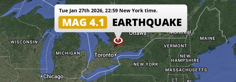
In the evening of Tuesday January 27th, 2026, an unusually powerful MAG-4.1 earthquake hit under land 98 kilometer from Toronto in Canada. The earthquake struck near a very densely populated region. Shaking may have been felt by a total of 14 million people. Another nearby country is The United States.
Felt the earthquake? Share this article: 


Earthquake Summary
The earthquake struck on land in Canada, 98 kilometer (61 mi) north of Toronto in Ontario. The center of this earthquake had a very shallow depth of 9 km. Shallow earthquakes usually have a larger impact than earthquakes deep in the earth.
| Date and Time: | Jan 27, 2026 22:59 (Toronto Time) - Jan 28, 2026 03:59 Universal Time. |
|---|---|
| Location: | 98 km north of Toronto, Ontario, Canada. Coordinates 44°33'10"N 79°7'26"W. |
| Map: | 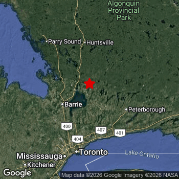 Map of area around epicenter. Click to open in Google Maps. |
| Magnitude: | MAG 4.1 Detected by 27 stations. Maximum Error Range ±0.101 . |
| Depth: | 9 km (5 mi) A very shallow depth. |
| Max. Intensity: | V
Moderate On the Modified Mercalli Scale. |
| Tsunami Risk: | Tsunami very unlikely While this was a shallow earthquake, it appears to have occurred under land with a magnitude not strong enough to cause tsunami's. Always stay cautious - More info here. |
Minimal impact predicted
Based on scientific estimates by the US Geographic Survey (USGS), the risk of high fatalities for this earthquake is classified at level GREEN (low). They expect an 65% likelyhood of between 0 and 1 fatalities, and a 96% chance that the number of fatalities falls no higher than 10.
The USGS classifies the economic impact of this earthquake at level GREEN (low). They expect an 65% likelyhood of between 0 and 1 million US Dollars in economic damage and impact, and a 96% chance that the economic impact of this earthquake falls no higher than 10 million USD.
Roughly 14 million people exposed to shaking
An estimated 14 million have been exposed to shaking (An MMI or Modified Mercalli Intensity level II or higher) as a result of this earthquake according scientific estimates published by the USGS.
The highest earthquake impact level for this earthquake is V, which corresponds with moderate shaking and very light damage. Roughly 2,450 people are expected to be exposed to this level. Intensity level III was experienced by the majority of people (around 13 million). In their region, weak shaking and probably no damage can be expected. All exposure to shaking was within the borders of Canada .
| People | MMI Level | Shaking | Damage |
|---|---|---|---|
| 0 | I |
Not noticable | None |
| 887,200 | II |
Very weak | None |
| 13,420,000 | III |
Weak | Probably none |
| 135,500 | IV |
Light | Likely none |
| 2,450 | V |
Moderate | Very light |
| 0 | VI |
Strong | Light |
| 0 | VII |
Very Strong | Moderate |
| 0 | VIII |
Severe | Moderate to heavy |
| 0 | IX |
Violent | Heavy |
| 0 | X |
Extreme | Very heavy |
Nearby towns and cities
Canada and The United States are both located within 300km distance of the epicenter of the earthquake.
The closest significant population center near the earthquake is Orillia in Ontario, Canada. Orillia is located 24 kilometer (15 mi) east of the epicenter. The intensity of shaking and damage in Orillia is estimated to be around level IV on the Modified Mercalli Intensity scale (light shaking, likely no damage).
Multiple major population centers exist within 300km of the earthquake that struck today. Toronto is located 98 km to the south and experienced an intensity of III (weak shaking, probably no damage). Mississauga is located 116 km to the south and experienced an intensity of III (weak shaking, probably no damage). Brampton is located 109 km to the southwest and experienced an intensity of III (weak shaking, probably no damage).
The table below provides an overview of all places in proximity of today's earthquake. Where available, the estimated intensity on the Modified Mercalli Intensity Scale in each place is included. Places where this information is omitted likely experienced little impact.
Overview of nearby places
| Distance | Place | Intensity (MMI) |
|---|---|---|
| 24 km (15 mi) W from epicenter |
Orillia Ontario, Canada. |
IV
Light |
| 38 km (24 mi) SE from epicenter |
Lindsay Ontario, Canada. |
III
Weak |
| 43 km (27 mi) SW from epicenter |
Keswick Ontario, Canada. |
III
Weak |
| 46 km (29 mi) W from epicenter |
Barrie Ontario, Canada. |
III
Weak |
| 50 km (31 mi) S from epicenter |
Uxbridge Ontario, Canada. |
III
Weak |
| 56 km (35 mi) SW from epicenter |
East Gwillimbury Ontario, Canada. |
III
Weak |
| 56 km (35 mi) N from epicenter |
Bracebridge Ontario, Canada. |
III
Weak |
| 62 km (39 mi) SW from epicenter |
Newmarket Ontario, Canada. |
III
Weak |
| 64 km (40 mi) W from epicenter |
Midland Ontario, Canada. |
III
Weak |
| 67 km (42 mi) SW from epicenter |
Aurora Ontario, Canada. |
III
Weak |
| 70 km (43 mi) SE from epicenter |
Peterborough Ontario, Canada. |
III
Weak |
| 71 km (44 mi) W from epicenter |
Wasaga Beach Ontario, Canada. |
III
Weak |
| 73 km (45 mi) S from epicenter |
Pickering Ontario, Canada. |
III
Weak |
| 74 km (46 mi) SW from epicenter |
Alliston Ontario, Canada. |
III
Weak |
| 76 km (47 mi) S from epicenter |
Oshawa Ontario, Canada. |
III
Weak |
| 77 km (48 mi) S from epicenter |
Markham Ontario, Canada. |
III
Weak |
| 78 km (48 mi) S from epicenter |
Ajax Ontario, Canada. |
III
Weak |
| 80 km (50 mi) S from epicenter |
Richmond Hill Ontario, Canada. |
III
Weak |
| 82 km (51 mi) S from epicenter |
Milliken Ontario, Canada. |
III
Weak |
| 83 km (52 mi) S from epicenter |
Rouge Ontario, Canada. |
III
Weak |
| 83 km (52 mi) S from epicenter |
Malvern Ontario, Canada. |
III
Weak |
| 84 km (52 mi) S from epicenter |
Steeles Ontario, Canada. |
III
Weak |
| 84 km (52 mi) S from epicenter |
Agincourt North Ontario, Canada. |
III
Weak |
| 85 km (53 mi) S from epicenter |
Vaughan Ontario, Canada. |
III
Weak |
| 86 km (53 mi) S from epicenter |
Agincourt South-Malvern West Ontario, Canada. |
III
Weak |
| 86 km (53 mi) S from epicenter |
L'Amoreaux Ontario, Canada. |
III
Weak |
| 87 km (54 mi) S from epicenter |
West Hill Ontario, Canada. |
III
Weak |
| 87 km (54 mi) S from epicenter |
Tam O'Shanter-Sullivan Ontario, Canada. |
III
Weak |
| 87 km (54 mi) W from epicenter |
Collingwood Ontario, Canada. |
III
Weak |
| 88 km (55 mi) S from epicenter |
Woburn Ontario, Canada. |
III
Weak |
| 88 km (55 mi) S from epicenter |
Bendale Ontario, Canada. |
III
Weak |
| 88 km (55 mi) S from epicenter |
Don Valley Village Ontario, Canada. |
III
Weak |
| 89 km (55 mi) S from epicenter |
Newtonbrook West Ontario, Canada. |
III
Weak |
| 90 km (56 mi) S from epicenter |
Parkwoods-Donalda Ontario, Canada. |
III
Weak |
| 90 km (56 mi) S from epicenter |
Dorset Park Ontario, Canada. |
III
Weak |
| 90 km (56 mi) S from epicenter |
Willowdale East Ontario, Canada. |
III
Weak |
| 90 km (56 mi) S from epicenter |
Willowdale Ontario, Canada. |
III
Weak |
| 90 km (56 mi) S from epicenter |
Westminster-Branson Ontario, Canada. |
III
Weak |
| 91 km (57 mi) S from epicenter |
Wexford/Maryvale Ontario, Canada. |
III
Weak |
| 92 km (57 mi) S from epicenter |
Banbury-Don Mills Ontario, Canada. |
III
Weak |
| 92 km (57 mi) S from epicenter |
York University Heights Ontario, Canada. |
III
Weak |
| 94 km (58 mi) S from epicenter |
Clairlea-Birchmount Ontario, Canada. |
III
Weak |
| 95 km (59 mi) S from epicenter |
Glenfield-Jane Heights Ontario, Canada. |
III
Weak |
| 96 km (60 mi) S from epicenter |
Downsview-Roding-CFB Ontario, Canada. |
III
Weak |
| 97 km (60 mi) S from epicenter |
Mount Pleasant West Ontario, Canada. |
III
Weak |
| 97 km (60 mi) S from epicenter |
Mount Olive-Silverstone-Jamestown Ontario, Canada. |
III
Weak |
| 98 km (61 mi) S from epicenter |
Toronto Ontario, Canada. |
III
Weak |
| 100 km (62 mi) S from epicenter |
West Humber-Clairville Ontario, Canada. |
III
Weak |
| 109 km (68 mi) SW from epicenter |
Brampton Ontario, Canada. |
III
Weak |
| 116 km (72 mi) S from epicenter |
Mississauga Ontario, Canada. |
III
Weak |
| 156 km (97 mi) S from epicenter |
Hamilton Ontario, Canada. |
III
Weak |
| 116 mi (186 km) S from epicenter |
Buffalo New York, The United States. |
III
Weak |
| 174 mi (280 km) S from epicenter |
Erie Pennsylvania, The United States. |
|
| 288 km (179 mi) E from epicenter |
Gatineau Quebec, Canada. |
Earthquake Intensity Map
The intensity in shaking and damage by this earthquake is illustrated through the map below. The highest intensity measured for this earthquake is V.

Shaking reported by 542 people
People that feel an earthquake may report their experience to the US Geographic Survey. Currently, 542 people have reported shaking in 67 places, all within Canada.We keep updating this article as more ground reports become available. You may report that you felt this earthquake here.
Places with most reports:
- Toronto, Ontario, Canada: 97 people.
- Brooklin, Ontario, Canada: 58 people.
- Whitchurch-Stouffville, Ontario, Canada: 35 people.
- Oshawa, Ontario, Canada: 32 people.
- Lindsay, Ontario, Canada: 29 people.
- Beaverton, Ontario, Canada: 27 people.
- Sutton, Ontario, Canada: 25 people.
- Peterborough, Ontario, Canada: 17 people.
- Uxbridge, Ontario, Canada: 17 people.
- Cannington, Ontario, Canada: 17 people.
Risk of aftershocks?
We monitor for foreshocks or aftershocks that have a magnitude of 2.5+ and occur within 100km (62 mi) of the epicenter of this earthquake. So far no such earthquakes have been detected.
Aftershocks are usually at least 1 order of magnitude less strong than main shocks. The more time passes, the smaller the chance and likely strength of any potential aftershocks.
It's always adviced to be cautious of the risk of a larger shock following any significant earthquake, however this risk is fairly small. There is a roughly 94 percent change that no larger main shock will follow in the days following this earthquake.
Read: How to Stay Safe during an Earthquake (cdc.gov).This is an unusually powerful earthquake
No earthquake of this strength has struck this region for a long time. Our data goes back 10 years, and no earthquakes measuring a magnitude of 4.1 or higher have been detected within 300 km (186 mi) of this epicenter.
Tsunami very unlikely
While MAG-6.5+ earthquakes may cause tsunami's, it appears that the epicenter of this earthquake hit under land. In addition, the reported depth is deeper than 100km, making the risk of a tsunami even less likely. However always stay cautious and monitor advice from local authorities.
Tsunami Risk Factors
| Factor | Under Sea? | MAG-6.5 or stronger? | Shallow depth? |
|---|---|---|---|
| Explanation | Almost all tsunami's are caused by earthquakes with their epicenter under sea or very near the sea. However stay cautious in coastal areas as earthquakes on land may cause landslides into sea, potentially still causing a local tsunami. | Under MAG 6.5: Very unlikely to cause a tsunami. MAG 6.5 to 7.5: Destructive tsunami's do occur, but are uncommon. Likely to observe small sea level changes. MAG 7.6+: Earthquakes with these magnitudes might produce destructive tsunami's. |
Most destructive tsunami's are caused by shallow earthquakes with a depth between 0 and 100km under the surface of the earth. Deeper tsunami's are unlikely to displace to ocean floor. |
| This Earthquake | Not this earthquake. This earthquake appears to have struck on land far from any coast. |
Not this earthquake. This earthquake had a magnitude of 4.1. Earthquakes of this strength are unlikely to trigger a tsunami. |
This earthquake occurred at a depth of of 9 km (5 mi). Earthquakes this shallow could trigger a tsunami. |
Sources
Last updated 28/03/26 06:58 (). This article contains currently available information about the earthquake and is automatically composed. We continue to update this article up to a few days after the earthquake occurred.
- US Geographic Society (USGS): Earthquake us6000s4xb
- Geonames.org: World Cities Database
- Google Maps: Static API
- Earthquakelist.org: Historic Earthquakes Database
Share this article:
