Latest earthquakes near India today
Complete overview of the latest earthquakes near the country India, updated every minute. Did you feel an earthquake today in India? If an earthquake is happening right now near India, it will show up within minutes.
Recent India Earthquake News
These are the latest articles published related to earthquakes occurring near India. Check our Earthquake News section for a complete overview of articles written on earthquakes near India and elsewhere.
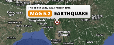 Feb 6, 2026 06:03AM
On Friday Morning a Shallow M5.2 Earthquake struck near Mawlaik in Myanmar.
Feb 6, 2026 06:03AM
On Friday Morning a Shallow M5.2 Earthquake struck near Mawlaik in Myanmar.
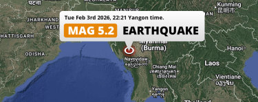 Feb 3, 2026 09:21PM
Significant M5.1 AFTERSHOCK hit near Yenangyaung in Myanmar on Tuesday Evening.
Feb 3, 2026 09:21PM
Significant M5.1 AFTERSHOCK hit near Yenangyaung in Myanmar on Tuesday Evening.
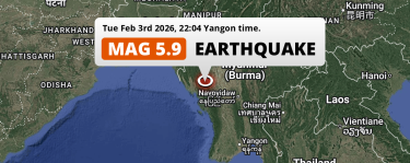 Feb 3, 2026 09:04PM
Significant M5.8 Earthquake struck on Tuesday Evening near Yenangyaung in Myanmar.
Feb 3, 2026 09:04PM
Significant M5.8 Earthquake struck on Tuesday Evening near Yenangyaung in Myanmar.
 Jan 22, 2026 03:13AM
Shallow M5.2 Earthquake hit 156km from Tinsukia in India on Thursday Night.
Jan 22, 2026 03:13AM
Shallow M5.2 Earthquake hit 156km from Tinsukia in India on Thursday Night.
 Nov 21, 2025 10:08AM
Shallow M5.4 Earthquake hit near Dhaka in Bangladesh on Friday Morning.
Nov 21, 2025 10:08AM
Shallow M5.4 Earthquake hit near Dhaka in Bangladesh on Friday Morning.
 Sep 14, 2025 04:41PM
DAMAGING M5.5 Earthquake hit near Guwahati in India on Sunday Afternoon.
Sep 14, 2025 04:41PM
DAMAGING M5.5 Earthquake hit near Guwahati in India on Sunday Afternoon.
India Earthquake Statistics
Average
A total of 2553 earthquakes with a magnitude of four or above have struck within 300 km (186 mi) of India in the past 10 years. This comes down to a yearly average of 255 earthquakes per year, or 21 per month. On average an earthquake will hit near India roughly every 1 days.
A relatively large number of earthquakes occurred near India in 2025. A total of 451 earthquakes (mag 4+) were detected within 300 km of India that year. The strongest had a 7.1 magnitude.

Magnitude Distribution
The table below visualizes the distribution of all earthquakes that occurred within 300km of India in the past 10 years. No earthquakes with a magnitude of 8 or above have occurred near India during this time. Usually, higher magnitudes are less common than lower magnitudes. Small earthquakes with a magnitude below 4 on the Richter scale have been omitted from this overview.
| Magnitude | Earthquakes | Percentage |
|---|---|---|
| Mag. 4 | 2340 | 91.66% |
| Mag. 5 | 207 | 8.11% |
| Mag. 6 | 5 | 0.2% |
| Mag. 7 | 1 | 0.04% |
| Mag. 8 | 0 | 0.0% |
| Mag. 9 | 0 | 0.0% |
| Mag. 10 | 0 | 0.0% |
Strongest earthquakes near India
The strongest recent earthquake of the past 10 years near India occurred on Jan 7, 2025 06:35 local time (Asia/Kolkata timezone). It had a magnitude of 7.1 and struck 235 kilometers (146 mi) north-northwest of Siliguri, at a depth of 10 km. Discover more strong earthquakes near India in the list below.
A longer time ago, a MAG-8.6 earthquake struck on Aug 15, 1950 19:39, 180 kilometers (112 mi) north-northwest of Dibrugarh. It is the strongest earthquake near India in the past 126 years (Our data goes back to January 1st, 1900).
In the table below you will find the strongest earthquakes that occurred near India in the past 10 years. You can use the tabs to find the heaviest historic earthquakes since the year 1900 or within a specific year or distance from India.
Earthquakes by region of India
Click the links below for earthquake reports for regions in India.
- Andaman and Nicobar
- Andhra Pradesh
- Arunachal Pradesh
- Assam (အာသံပြည်နယ်)
- Bihar
- Chandigarh
- Chhattisgarh
- Dadra and Nagar Haveli and Daman and Diu
- Delhi
- Goa
- Gujarat
- Haryana
- Himachal Pradesh
- Jammu and Kashmir
- Jharkhand
- Karnataka
- Kerala
- Ladakh (拉達克)
- Madhya Pradesh
- Maharashtra
- Manipur (မဏိပူရပြည်နယ်)
- Meghalaya
- Mizoram
- Nagaland (Nāgāland)
- Odisha
- Puducherry
- Punjab
- Rajasthan (راجستھان)
- Sikkim
- Tamil Nadu
- Telangana
- Tripura
- Uttar Pradesh
- Uttarakhand (State of Uttarākhand)
- West Bengal
Frequently Asked Questions
These questions are commonly asked in relation to earthquakes occurring near India.
When was the last earthquake in India?
A 3.2 magnitude earthquake hit near India on the night of February 19, 2026 at 02:33 local time (Asia/Kolkata). The center of this earthquake was located 93km west of Guntur at a depth of 5km under land. Check the list on our website for any earthquakes occurring near India in the past hours.
What was the strongest earthquake near India?
A 8.6 magnitude earthquake hit near India on the evening of August 15, 1950 at 19:39 local time (Asia/Kolkata). The center of this earthquake was located 180km north-east of Dibrugarh at a depth of 15km under land. This is the strongest earthquake that occurred near India since the year 1900.
How often do earthquakes occur near India?
In the past 10 years, 2553 earthquakes with a magnitude of four or higher occurred within a 300 kilometer range from India. This averages to 255 earthquakes yearly, or one earthquake every 1 days.
