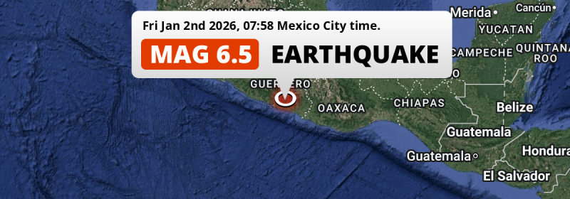
A shallow and strong Magnitude 6.5 earthquake struck under land 61 kilometer from Acapulco de Juárez in Mexico in the morning of Friday January 2nd, 2026. The USGS has indicated there is a potential risk at tsunami's following this earthquake.
Felt the earthquake? Share this article: 


Earthquake Summary
The earthquake struck on land in Mexico, 61 kilometer (38 mi) east of Acapulco de Juárez in Guerrero. The center of this earthquake had a very shallow depth of 18 km. Shallow earthquakes usually have a larger impact than earthquakes deep in the earth.
| Date and Time: | Jan 2, 2026 07:58 (Mexico City Time) - Jan 2, 2026 13:58 Universal Time. |
|---|---|
| Location: | 61 km east of Acapulco de Juárez, Guerrero, Mexico. Coordinates 16°52'31"N 99°20'10"W. |
| Map: | 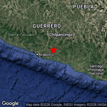 Map of area around epicenter. Click to open in Google Maps. |
| Magnitude: | MAG 6.5 Detected by 21 stations. Maximum Error Range ±0.027 . |
| Depth: | 18 km (11 mi) A very shallow depth. |
| Max. Intensity: | VIII
Severe On the Modified Mercalli Scale. |
| Tsunami Risk: | Potential tsunami risk The USGS has indicated there is a potential risk at tsunami's following this earthquake. Always stay cautious - More info here. |
Potential tsunami risk
There is a potential tsunami risk in the aftermath of this earthquake, immediately evacuate to higher grounds away from coastal areas and monitor advice from local authorities. The US Geographic Survey organization has indicated a potential risk for tsunami's following this earthquake.
Tsunami Risk Factors
| Factor | Under Sea? | MAG-6.5 or stronger? | Shallow depth? |
|---|---|---|---|
| Explanation | Almost all tsunami's are caused by earthquakes with their epicenter under sea or very near the sea. However stay cautious in coastal areas as earthquakes on land may cause landslides into sea, potentially still causing a local tsunami. | Under MAG 6.5: Very unlikely to cause a tsunami. MAG 6.5 to 7.5: Destructive tsunami's do occur, but are uncommon. Likely to observe small sea level changes. MAG 7.6+: Earthquakes with these magnitudes might produce destructive tsunami's. |
Most destructive tsunami's are caused by shallow earthquakes with a depth between 0 and 100km under the surface of the earth. Deeper tsunami's are unlikely to displace to ocean floor. |
| This Earthquake | This earthquake appears to have struck on land near a coastal area (24 km from the sea). | This earthquake had a magnitude of 6.5. Earthquakes of this strength could trigger a tsunami. | This earthquake occurred at a depth of of 18 km (11 mi). Earthquakes this shallow could trigger a tsunami. |
Significant impact predicted
The US Geographic Survey (USGS) describes the impact of this earthquake as follows:
One person killed, 12 injured, 70 homes destroyed, 5310 damaged and several buildings damaged in Guerrero. Landslides reported at Acapulco and Chilpancingo. One person killed, 12 injured some buildings destroyed, several homes and buildings damaged; and power outages at Mexico City. Some homes damaged in Morelos.
Based on scientific estimates by the USGS, the risk of high fatalities for this earthquake is classified at level YELLOW (significant). They expect an 40% likelyhood of between 10 and 100 fatalities, and a 94% chance that the number of fatalities falls no higher than 1,000.
The USGS classifies the economic impact of this earthquake at level YELLOW (significant). They expect an 38% likelyhood of between 10 and 100 million US Dollars in economic damage and impact, and a 94% chance that the economic impact of this earthquake falls between 1 and 10,000 million USD.
Roughly 5.3 million people exposed to shaking
An estimated 5.3 million have been exposed to shaking (An MMI or Modified Mercalli Intensity level II or higher) as a result of this earthquake according scientific estimates published by the USGS.
An estimated 94,250 people were exposed to level VII. At this level, very strong shaking and likely moderate damage can be expected. Intensity level IV was experienced by the majority of people (around 3.2 million). In their region, light shaking and likely no damage can be expected. All exposure to shaking was within the borders of Mexico .
| People | MMI Level | Shaking | Damage |
|---|---|---|---|
| 0 | I |
Not noticable | None |
| 0 | II |
Very weak | None |
| 630,900 | III |
Weak | Probably none |
| 3,180,000 | IV |
Light | Likely none |
| 1,125,000 | V |
Moderate | Very light |
| 290,000 | VI |
Strong | Light |
| 94,250 | VII |
Very Strong | Moderate |
| 0 | VIII |
Severe | Moderate to heavy |
| 0 | IX |
Violent | Heavy |
| 0 | X |
Extreme | Very heavy |
Nearby towns and cities
This earthquake may have been felt in Mexico . The closest significant population center near the earthquake is Ayutla de los Libres in Guerrero, Mexico. Ayutla de los Libres is located 27 kilometer (17 mi) west-southwest of the epicenter. The intensity of shaking and damage in Ayutla de los Libres is estimated to be around level VI on the Modified Mercalli Intensity scale (strong shaking, probably light damage).
Major cities near this earthquake: Mexico City is located 285 km to the north (intensity unknown, possibly low). Acapulco de Juárez is located 61 km to the west and experienced an intensity of V (moderate shaking, very light damage). Iztapalapa is located 277 km to the north (intensity unknown, possibly low).
The table below provides an overview of all places in proximity of today's earthquake. Where available, the estimated intensity on the Modified Mercalli Intensity Scale in each place is included. Places where this information is omitted likely experienced little impact.
Overview of nearby places
| Distance | Place | Intensity (MMI) |
|---|---|---|
| 27 km (17 mi) ENE from epicenter |
Ayutla de los Libres Guerrero, Mexico. |
VI
Strong |
| 61 km (38 mi) W from epicenter |
Acapulco de Juárez Guerrero, Mexico. |
V
Moderate |
| 77 km (48 mi) N from epicenter |
Tixtla de Guerrero Guerrero, Mexico. |
V
Moderate |
| 77 km (48 mi) NNW from epicenter |
Chilpancingo Guerrero, Mexico. |
IV
Light |
| 82 km (51 mi) NNE from epicenter |
Chilapa de Álvarez Guerrero, Mexico. |
V
Moderate |
| 89 km (55 mi) NNW from epicenter |
Zumpango del Río Guerrero, Mexico. |
V
Moderate |
| 101 km (63 mi) E from epicenter |
Ometepec Guerrero, Mexico. |
IV
Light |
| 110 km (68 mi) NE from epicenter |
Tlapa de Comonfort Guerrero, Mexico. |
IV
Light |
| 122 km (76 mi) WNW from epicenter |
Atoyac de Álvarez Guerrero, Mexico. |
IV
Light |
| 149 km (93 mi) ESE from epicenter |
Pinotepa Nacional Oaxaca, Mexico. |
IV
Light |
| 165 km (103 mi) N from epicenter |
Iguala de la Independencia Guerrero, Mexico. |
V
Moderate |
| 175 km (109 mi) NNW from epicenter |
Teloloapan Guerrero, Mexico. |
IV
Light |
| 189 km (117 mi) N from epicenter |
Taxco de Alarcón Guerrero, Mexico. |
III
Weak |
| 195 km (121 mi) ENE from epicenter |
Ciudad de Huajuapan de León Oaxaca, Mexico. |
IV
Light |
| 219 km (136 mi) N from epicenter |
Cuautla Morelos, Mexico. |
|
| 220 km (137 mi) N from epicenter |
Temixco Morelos, Mexico. |
|
| 224 km (139 mi) N from epicenter |
Jiutepec Morelos, Mexico. |
|
| 228 km (142 mi) N from epicenter |
Cuernavaca Morelos, Mexico. |
|
| 266 km (165 mi) N from epicenter |
Xochimilco Mexico City, Mexico. |
|
| 269 km (167 mi) N from epicenter |
Chalco México, Mexico. |
|
| 269 km (167 mi) N from epicenter |
Xico México, Mexico. |
|
| 269 km (167 mi) NNE from epicenter |
Puebla Puebla, Mexico. |
|
| 270 km (168 mi) N from epicenter |
Toluca México, Mexico. |
|
| 270 km (168 mi) N from epicenter |
Tlalpan Mexico City, Mexico. |
|
| 270 km (168 mi) N from epicenter |
Tláhuac Mexico City, Mexico. |
|
| 271 km (168 mi) NE from epicenter |
Tehuacán Puebla, Mexico. |
|
| 274 km (170 mi) N from epicenter |
Magdalena Contreras Mexico City, Mexico. |
|
| 275 km (171 mi) N from epicenter |
Coyoacán Mexico City, Mexico. |
|
| 276 km (171 mi) N from epicenter |
Ixtapaluca México, Mexico. |
|
| 276 km (171 mi) N from epicenter |
Álvaro Obregón Mexico City, Mexico. |
|
| 277 km (172 mi) N from epicenter |
Delegación Cuajimalpa de Morelos Mexico City, Mexico. |
|
| 277 km (172 mi) N from epicenter |
Iztapalapa Mexico City, Mexico. |
|
| 278 km (173 mi) N from epicenter |
Benito Juárez Mexico City, Mexico. |
|
| 279 km (173 mi) E from epicenter |
Oaxaca Oaxaca, Mexico. |
|
| 280 km (174 mi) N from epicenter |
Colonia del Valle Mexico City, Mexico. |
|
| 281 km (175 mi) N from epicenter |
Iztacalco Mexico City, Mexico. |
|
| 283 km (176 mi) N from epicenter |
Ciudad Nezahualcoyotl México, Mexico. |
|
| 285 km (177 mi) N from epicenter |
Miguel Hidalgo Mexico City, Mexico. |
|
| 285 km (177 mi) N from epicenter |
Mexico City Mexico City, Mexico. |
|
| 286 km (178 mi) N from epicenter |
Chicoloapan México, Mexico. |
|
| 286 km (178 mi) N from epicenter |
Cuauhtémoc Mexico City, Mexico. |
|
| 286 km (178 mi) N from epicenter |
Santa María Chimalhuacán México, Mexico. |
|
| 287 km (178 mi) N from epicenter |
Venustiano Carranza Mexico City, Mexico. |
|
| 290 km (180 mi) N from epicenter |
Naucalpan de Juárez México, Mexico. |
|
| 291 km (181 mi) N from epicenter |
Azcapotzalco Mexico City, Mexico. |
|
| 292 km (181 mi) N from epicenter |
Gustavo Adolfo Madero Mexico City, Mexico. |
|
| 297 km (185 mi) N from epicenter |
Tlalnepantla México, Mexico. |
|
| 297 km (185 mi) NNE from epicenter |
Tlaxcala Tlaxcala, Mexico. |
|
| 298 km (185 mi) N from epicenter |
Ciudad López Mateos México, Mexico. |
|
| 305 km (190 mi) N from epicenter |
Ecatepec de Morelos México, Mexico. |
|
| 308 km (191 mi) N from epicenter |
Cuautitlán Izcalli México, Mexico. |
|
| 366 km (227 mi) N from epicenter |
Pachuca de Soto Hidalgo, Mexico. |
|
| 370 km (230 mi) NNW from epicenter |
Morelia Michoacán, Mexico. |
|
| 391 km (243 mi) NE from epicenter |
Xalapa de Enríquez Veracruz, Mexico. |
|
| 427 km (265 mi) NNW from epicenter |
Santiago de Querétaro Querétaro, Mexico. |
|
| 435 km (270 mi) NNW from epicenter |
Celaya Guanajuato, Mexico. |
|
| 491 km (305 mi) N from epicenter |
Tamazunchale San Luis Potosí, Mexico. |
Earthquake Intensity Map
The intensity in shaking and damage by this earthquake is illustrated through the map below. The highest intensity measured for this earthquake is VII.

Shaking reported by 521 people
People that feel an earthquake may report their experience to the US Geographic Survey. Currently, 521 people have reported shaking in 130 places, all within Mexico.We keep updating this article as more ground reports become available. You may report that you felt this earthquake here.
Places with most reports:
- Mexico City, Distrito Federal, Mexico: 221 people.
- Acapulco, Guerrero, Mexico: 18 people.
- Naucalpan, México, Mexico: 17 people.
- Puebla, Puebla, Mexico: 15 people.
- Cuernavaca, Morelos, Mexico: 13 people.
- Nezahualcóyotl, México, Mexico: 11 people.
- Puerto Vallarta, Jalisco, Mexico: 11 people.
- Coatepec (San Bartolomé Coatepec), México, Mexico: 8 people.
- Oaxaca, Oaxaca, Mexico: 8 people.
- Zihuatanejo, Guerrero, Mexico: 7 people.
77 Aftershocks detected
This main shock was followed by 77 smaller aftershocks. Just 2 hrs after this main shock, an earthquake measuring MAG-4.6 was detected 7 km (4 mi) south-east of this earthquake.
This main shock was prefaced by 2 smaller foreshocks. A 3.2 magnitude earthquake hit 3 days earlier nearby.
Overview of foreshocks and aftershocks
| Classification | Magnitude | When | Where |
|---|---|---|---|
| Foreshock | M 3.2 |
3 days earlier Dec 30, 2025 12:46 (Mexico City Time) | 61 km (38 mi) WNW from Main Shock. |
| Foreshock | M 3.0 |
2 days earlier Dec 31, 2025 04:48 (Mexico City Time) | 89 km (56 mi) ESE from Main Shock. |
| Main Shock This Earthquake |
M 6.5 |
Jan 2, 2026 07:58 (Mexico City Time) | - |
| Aftershock | M 4.3 |
19 mins later Jan 2, 2026 08:17 (Mexico City Time) | 83 km (51 mi) SSE from Main Shock. |
| Aftershock | M 4.0 |
49 mins later Jan 2, 2026 08:46 (Mexico City Time) | 19 km (12 mi) SW from Main Shock. |
| Aftershock | M 4.1 |
1 hr later Jan 2, 2026 09:08 (Mexico City Time) | 22 km (14 mi) WSW from Main Shock. |
| Aftershock | M 4.3 |
2 hrs later Jan 2, 2026 09:34 (Mexico City Time) | 9 km (6 mi) SE from Main Shock. |
| Aftershock | M 4.6 |
2 hrs later Jan 2, 2026 09:37 (Mexico City Time) | 7 km (4 mi) SE from Main Shock. |
| Aftershock | M 4.0 |
2 hrs later Jan 2, 2026 10:24 (Mexico City Time) | 20 km (12 mi) WSW from Main Shock. |
| Aftershock | M 4.0 |
3 hrs later Jan 2, 2026 10:28 (Mexico City Time) | 22 km (13 mi) SW from Main Shock. |
| Aftershock | M 4.1 |
3 hrs later Jan 2, 2026 10:36 (Mexico City Time) | 23 km (14 mi) WSW from Main Shock. |
| Aftershock | M 4.1 |
3 hrs later Jan 2, 2026 10:43 (Mexico City Time) | 24 km (15 mi) WSW from Main Shock. |
| Aftershock | M 4.5 |
3 hrs later Jan 2, 2026 11:00 (Mexico City Time) | 8 km (5 mi) SW from Main Shock. |
| Aftershock | M 4.0 |
5 hrs later Jan 2, 2026 13:25 (Mexico City Time) | 30 km (19 mi) SW from Main Shock. |
| Aftershock | M 4.0 |
7 hrs later Jan 2, 2026 14:53 (Mexico City Time) | 20 km (13 mi) SW from Main Shock. |
| Aftershock | M 4.0 |
7 hrs later Jan 2, 2026 15:18 (Mexico City Time) | 25 km (15 mi) SW from Main Shock. |
| Aftershock | M 4.2 |
7 hrs later Jan 2, 2026 15:19 (Mexico City Time) | 24 km (15 mi) SW from Main Shock. |
| Aftershock | M 4.1 |
8 hrs later Jan 2, 2026 15:37 (Mexico City Time) | 31 km (19 mi) SW from Main Shock. |
| Aftershock | M 4.0 |
8 hrs later Jan 2, 2026 15:42 (Mexico City Time) | 32 km (20 mi) SW from Main Shock. |
| Aftershock | M 3.0 |
9 hrs later Jan 2, 2026 16:35 (Mexico City Time) | 25 km (16 mi) WSW from Main Shock. |
| Aftershock | M 3.1 |
9 hrs later Jan 2, 2026 16:36 (Mexico City Time) | 26 km (16 mi) WSW from Main Shock. |
| Aftershock | M 3.1 |
9 hrs later Jan 2, 2026 16:50 (Mexico City Time) | 24 km (15 mi) SW from Main Shock. |
| Aftershock | M 3.0 |
9 hrs later Jan 2, 2026 16:59 (Mexico City Time) | 28 km (17 mi) SW from Main Shock. |
| Aftershock | M 4.0 |
9 hrs later Jan 2, 2026 17:06 (Mexico City Time) | 31 km (19 mi) SW from Main Shock. |
| Aftershock | M 4.0 |
11 hrs later Jan 2, 2026 18:34 (Mexico City Time) | 27 km (17 mi) SW from Main Shock. |
| Aftershock | M 4.1 |
11 hrs later Jan 2, 2026 18:37 (Mexico City Time) | 29 km (18 mi) SW from Main Shock. |
| Aftershock | M 4.1 |
11 hrs later Jan 2, 2026 18:59 (Mexico City Time) | 25 km (15 mi) SW from Main Shock. |
| Aftershock | M 4.1 |
12 hrs later Jan 2, 2026 19:29 (Mexico City Time) | 21 km (13 mi) SW from Main Shock. |
| Aftershock | M 4.3 |
12 hrs later Jan 2, 2026 19:34 (Mexico City Time) | 22 km (14 mi) WSW from Main Shock. |
| Aftershock | M 4.1 |
13 hrs later Jan 2, 2026 20:43 (Mexico City Time) | 23 km (14 mi) SW from Main Shock. |
| Aftershock | M 4.0 |
13 hrs later Jan 2, 2026 20:57 (Mexico City Time) | 22 km (14 mi) SW from Main Shock. |
| Aftershock | M 4.1 |
13 hrs later Jan 2, 2026 21:03 (Mexico City Time) | 29 km (18 mi) WSW from Main Shock. |
| Aftershock | M 4.0 |
13 hrs later Jan 2, 2026 21:06 (Mexico City Time) | 27 km (17 mi) SW from Main Shock. |
| Aftershock | M 4.0 |
17 hrs later Jan 3, 2026 01:15 (Mexico City Time) | 32 km (20 mi) SW from Main Shock. |
| Aftershock | M 4.0 |
18 hrs later Jan 3, 2026 01:28 (Mexico City Time) | 28 km (18 mi) SW from Main Shock. |
| Aftershock | M 3.6 |
20 hrs later Jan 3, 2026 03:39 (Mexico City Time) | 26 km (16 mi) SSW from Main Shock. |
| Aftershock | M 3.7 |
20 hrs later Jan 3, 2026 03:44 (Mexico City Time) | 29 km (18 mi) SW from Main Shock. |
| Aftershock | M 3.5 |
20 hrs later Jan 3, 2026 03:55 (Mexico City Time) | 94 km (58 mi) W from Main Shock. |
| Aftershock | M 3.4 |
20 hrs later Jan 3, 2026 04:05 (Mexico City Time) | 22 km (14 mi) SW from Main Shock. |
| Aftershock | M 3.4 |
20 hrs later Jan 3, 2026 04:13 (Mexico City Time) | 29 km (18 mi) SSW from Main Shock. |
| Aftershock | M 3.4 |
21 hrs later Jan 3, 2026 04:42 (Mexico City Time) | 16 km (10 mi) SSW from Main Shock. |
| Aftershock | M 3.4 |
21 hrs later Jan 3, 2026 04:44 (Mexico City Time) | 31 km (19 mi) SW from Main Shock. |
| Aftershock | M 3.8 |
21 hrs later Jan 3, 2026 04:47 (Mexico City Time) | 23 km (14 mi) SSW from Main Shock. |
| Aftershock | M 3.9 |
21 hrs later Jan 3, 2026 04:58 (Mexico City Time) | 19 km (12 mi) WSW from Main Shock. |
| Aftershock | M 4.2 |
1 day later Jan 3, 2026 09:43 (Mexico City Time) | 26 km (16 mi) WSW from Main Shock. |
| Aftershock | M 4.0 |
1 day later Jan 3, 2026 12:36 (Mexico City Time) | 30 km (19 mi) SW from Main Shock. |
| Aftershock | M 4.0 |
1 day later Jan 3, 2026 16:01 (Mexico City Time) | 23 km (14 mi) WSW from Main Shock. |
| Aftershock | M 3.3 |
1 day later Jan 3, 2026 16:04 (Mexico City Time) | 28 km (17 mi) WSW from Main Shock. |
| Aftershock | M 3.6 |
1 day later Jan 3, 2026 16:09 (Mexico City Time) | 29 km (18 mi) SW from Main Shock. |
| Aftershock | M 3.3 |
1 day later Jan 3, 2026 16:30 (Mexico City Time) | 18 km (11 mi) SW from Main Shock. |
| Aftershock | M 3.4 |
1 day later Jan 3, 2026 16:40 (Mexico City Time) | 28 km (18 mi) SW from Main Shock. |
| Aftershock | M 3.0 |
1 day later Jan 3, 2026 16:43 (Mexico City Time) | 19 km (12 mi) SW from Main Shock. |
| Aftershock | M 3.0 |
1 day later Jan 3, 2026 16:54 (Mexico City Time) | 16 km (10 mi) SW from Main Shock. |
| Aftershock | M 4.0 |
1 day later Jan 3, 2026 18:40 (Mexico City Time) | 22 km (13 mi) SW from Main Shock. |
| Aftershock | M 4.3 |
2 days later Jan 3, 2026 20:22 (Mexico City Time) | 33 km (20 mi) SW from Main Shock. |
| Aftershock | M 4.0 |
2 days later Jan 3, 2026 20:35 (Mexico City Time) | 28 km (17 mi) SW from Main Shock. |
| Aftershock | M 3.9 |
2 days later Jan 4, 2026 03:55 (Mexico City Time) | 27 km (17 mi) SW from Main Shock. |
| Aftershock | M 3.3 |
2 days later Jan 4, 2026 04:00 (Mexico City Time) | 20 km (13 mi) SW from Main Shock. |
| Aftershock | M 3.2 |
2 days later Jan 4, 2026 04:12 (Mexico City Time) | 20 km (12 mi) WSW from Main Shock. |
| Aftershock | M 3.3 |
2 days later Jan 4, 2026 04:14 (Mexico City Time) | 27 km (17 mi) SW from Main Shock. |
| Aftershock | M 4.0 |
2 days later Jan 4, 2026 04:45 (Mexico City Time) | 28 km (17 mi) SW from Main Shock. |
| Aftershock | M 3.1 |
2 days later Jan 4, 2026 04:51 (Mexico City Time) | 24 km (15 mi) WSW from Main Shock. |
| Aftershock | M 4.0 |
2 days later Jan 4, 2026 06:39 (Mexico City Time) | 25 km (15 mi) WSW from Main Shock. |
| Aftershock | M 4.0 |
2 days later Jan 4, 2026 08:54 (Mexico City Time) | 27 km (17 mi) WSW from Main Shock. |
| Aftershock | M 4.0 |
2 days later Jan 4, 2026 09:53 (Mexico City Time) | 25 km (15 mi) SW from Main Shock. |
| Aftershock | M 4.1 |
2 days later Jan 4, 2026 13:08 (Mexico City Time) | 26 km (16 mi) SW from Main Shock. |
| Aftershock | M 4.0 |
2 days later Jan 4, 2026 13:43 (Mexico City Time) | 26 km (16 mi) WSW from Main Shock. |
| Aftershock | M 3.4 |
2 days later Jan 4, 2026 15:29 (Mexico City Time) | 27 km (17 mi) SW from Main Shock. |
| Aftershock | M 3.4 |
2 days later Jan 4, 2026 16:43 (Mexico City Time) | 28 km (18 mi) SW from Main Shock. |
| Aftershock | M 3.6 |
2 days later Jan 4, 2026 16:54 (Mexico City Time) | 24 km (15 mi) SW from Main Shock. |
| Aftershock | M 4.2 |
2 days later Jan 4, 2026 16:57 (Mexico City Time) | 21 km (13 mi) SW from Main Shock. |
| Aftershock | M 4.4 |
3 days later Jan 5, 2026 02:38 (Mexico City Time) | 89 km (55 mi) SE from Main Shock. |
| Aftershock | M 3.7 |
3 days later Jan 5, 2026 03:43 (Mexico City Time) | 88 km (55 mi) WNW from Main Shock. |
| Aftershock | M 3.2 |
3 days later Jan 5, 2026 03:50 (Mexico City Time) | 25 km (16 mi) WSW from Main Shock. |
| Aftershock | M 3.4 |
3 days later Jan 5, 2026 03:54 (Mexico City Time) | 82 km (51 mi) ESE from Main Shock. |
| Aftershock | M 3.4 |
3 days later Jan 5, 2026 03:56 (Mexico City Time) | 26 km (16 mi) WSW from Main Shock. |
| Aftershock | M 3.0 |
3 days later Jan 5, 2026 04:03 (Mexico City Time) | 21 km (13 mi) SW from Main Shock. |
| Aftershock | M 4.1 |
3 days later Jan 5, 2026 04:28 (Mexico City Time) | 28 km (18 mi) WSW from Main Shock. |
| Aftershock | M 3.5 |
3 days later Jan 5, 2026 04:54 (Mexico City Time) | 27 km (17 mi) SW from Main Shock. |
| Aftershock | M 4.2 |
3 days later Jan 5, 2026 05:26 (Mexico City Time) | 27 km (17 mi) SW from Main Shock. |
More earthquakes coming?
The risk of aftershocks decreases rapidly over time. Usually, aftershocks are at least one order of magnitude lower than a main shock.
The chance that a significant earthquake like this one is followed by an even larger earthquake is not so large. On average, scientists estimate a 94% chance that a major earthquake will not be followed by an even larger one. It is still adviced to be aware of this risk
Read: How to Stay Safe during an Earthquake (cdc.gov).This is the strongest earthquake in 4 years
Earthquakes of this strength occur quite regularly in the region. This is the strongest earthquake to hit since September 8th, 2021, when a 7 magnitude earthquake hit 45 km (28 mi) further west. An even stronger magnitude 7.2 earthquake struck on February 16th, 2018.
In total, 3 earthquakes with a magnitude of 6.5 or higher have been registered within 300km (186 mi) of this epicenter in the past 10 years. This comes down to an average of once every 3 years.
Sources
Last updated 18/02/26 04:08 (). This article is automatically generated based on available data. We keep checking multiple sources for additional information. This article gets updated as new details on this earthquake become available.
- US Geographic Society (USGS): Earthquake us7000rm3k
- European-Mediterranean Seismological Centre (EMSC): Earthquake 20260102_0000176
- Geonames.org: World Cities Database
- Google Maps: Static API
- Earthquakelist.org: Historic Earthquakes Database
Share this article:
