Latest earthquakes near Argentina today
Complete overview of the latest earthquakes near the country Argentina, updated every minute. Did you feel an earthquake today in Argentina? If an earthquake is happening right now near Argentina, it will show up within minutes.
Recent Argentina Earthquake News
These are the latest articles published related to earthquakes occurring near Argentina. Check our Earthquake News section for a complete overview of articles written on earthquakes near Argentina and elsewhere.
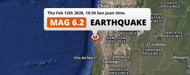 Feb 12, 2026 10:34AM
On Thursday Morning a Strong M6.2 Earthquake struck near Ovalle in Chile.
Feb 12, 2026 10:34AM
On Thursday Morning a Strong M6.2 Earthquake struck near Ovalle in Chile.
Argentina Earthquake Statistics
Average
A total of 4222 earthquakes with a magnitude of four or above have struck within 300 km (186 mi) of Argentina in the past 10 years. This comes down to a yearly average of 422 earthquakes per year, or 35 per month. On average an earthquake will hit near Argentina roughly every 0 days.
A relatively large number of earthquakes occurred near Argentina in 2025. A total of 538 earthquakes (mag 4+) were detected within 300 km of Argentina that year. The strongest had a 7.4 magnitude.

Magnitude Distribution
The table below visualizes the distribution of all earthquakes that occurred within 300km of Argentina in the past 10 years. No earthquakes with a magnitude of 8 or above have occurred near Argentina during this time. Usually, higher magnitudes are less common than lower magnitudes. Small earthquakes with a magnitude below 4 on the Richter scale have been omitted from this overview.
| Magnitude | Earthquakes | Percentage |
|---|---|---|
| Mag. 4 | 3984 | 94.36% |
| Mag. 5 | 210 | 4.97% |
| Mag. 6 | 25 | 0.59% |
| Mag. 7 | 3 | 0.07% |
| Mag. 8 | 0 | 0.0% |
| Mag. 9 | 0 | 0.0% |
| Mag. 10 | 0 | 0.0% |
Strongest earthquakes near Argentina
The strongest recent earthquake of the past 10 years near Argentina occurred on Dec 25, 2016 11:22 local time (America/Argentina/Catamarca timezone). It had a magnitude of 7.6 and struck 220 kilometers (137 mi) west-southwest of Esquel, at a depth of 38 km. Discover more strong earthquakes near Argentina in the list below.
A longer time ago, a MAG-8.2 earthquake struck on Aug 16, 1906 20:23, 247 kilometers (153 mi) west-southwest of Mendoza. It is the strongest earthquake near Argentina in the past 126 years (Our data goes back to January 1st, 1900).
In the table below you will find the strongest earthquakes that occurred near Argentina in the past 10 years. You can use the tabs to find the heaviest historic earthquakes since the year 1900 or within a specific year or distance from Argentina.
Earthquakes by region of Argentina
Click the links below for earthquake reports for regions in Argentina.
- Buenos Aires
- Buenos Aires F.D. (Buenos Aires C.F.)
- Catamarca
- Chaco
- Chubut
- Cordoba (Córdoba)
- Corrientes
- Entre Rios (Entre Ríos)
- Formosa
- Jujuy
- La Pampa
- La Rioja
- Mendoza
- Neuquen (Neuquén)
- Rio Negro (Río Negro)
- Salta
- San Juan
- San Luis
- Santa Cruz
- Santa Fe
- Santiago del Estero
- Tierra del Fuego
- Tucuman (Tucumán)
Frequently Asked Questions
These questions are commonly asked in relation to earthquakes occurring near Argentina.
When was the last earthquake in Argentina?
A 3.3 magnitude earthquake hit near Argentina on the evening of February 18, 2026 at 20:09 local time (America/Argentina/Salta). The center of this earthquake was located 235km west-northwest of Salta at a depth of 200km under land. Check the list on our website for any earthquakes occurring near Argentina in the past hours.
What was the strongest earthquake near Argentina?
A 8.2 magnitude earthquake hit near Argentina on the evening of August 16, 1906 at 20:23 local time (America/Argentina/Mendoza). The center of this earthquake was located 247km west-northwest of Mendoza at a depth of 35km under land. This is the strongest earthquake that occurred near Argentina since the year 1900.
How often do earthquakes occur near Argentina?
In the past 10 years, 4222 earthquakes with a magnitude of four or higher occurred within a 300 kilometer range from Argentina. This averages to 422 earthquakes yearly, or one earthquake every 1 days.
