
In the afternoon of Tuesday December 16th, 2025, a shallow and significant Magnitude 5.1 earthquake hit in the North Pacific Ocean 135 kilometer from Hachinohe, Japan.
Felt the earthquake? Share this article: 


Earthquake Summary
This earthquake hit under water in the North Pacific Ocean, 118 kilometers (73 mi) off the coast of Japan, 135 kilometer east-northeast of Hachinohe in Aomori. The center of this earthquake had a very shallow depth of 10 km. Shallow earthquakes usually have a larger impact than earthquakes deep in the earth.
| Date and Time: | Dec 16, 2025 14:38 (Tokyo Time) - Dec 16, 2025 05:38 Universal Time. |
|---|---|
| Location: | 135 km ENE of Hachinohe, Aomori, Japan. Coordinates 40°53'18"N 143°0'41"E. |
| Map: | 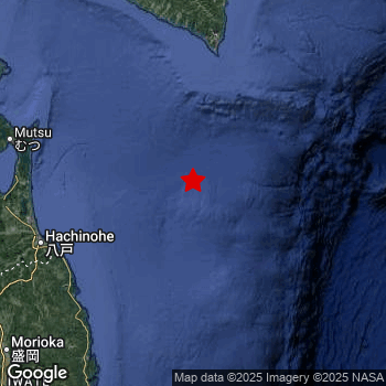 Map of area around epicenter. Click to open in Google Maps. |
| Magnitude: | MAG 5.1 Detected by 14 stations. Maximum Error Range ±0.083 . |
| Depth: | 10 km (6 mi) A very shallow depth. |
| Tsunami Risk: | Low tsunami risk Earthquakes under MAG-6.5 do not usually cause tsunami's. Always stay cautious - More info here. |
Nearby towns and cities
This earthquake may have been felt in Japan . The closest significant population center near the earthquake is Hachinohe in Aomori, Japan. Hachinohe is located 135 kilometer (84 mi) east-northeast of the epicenter.
Multiple large cities are in proximity of today's earthquake. Sapporo is located 278 km to the north-northwest. Hachinohe is located 135 km to the west-southwest. Aomori is located 192 km to the west.
A complete list of nearby places is included below.
Overview of nearby places
| Distance | Place |
|---|---|
| 135 km (84 mi) WSW from epicenter |
Hachinohe Aomori, Japan. |
| 138 km (86 mi) W from epicenter |
Misawa Aomori, Japan. |
| 157 km (98 mi) WNW from epicenter |
Mutsu Aomori, Japan. |
| 165 km (103 mi) SSW from epicenter |
Miyako Iwate, Japan. |
| 169 km (105 mi) NNW from epicenter |
Shizunai-furukawachō Hokkaido, Japan. |
| 182 km (113 mi) SSW from epicenter |
Yamada Iwate, Japan. |
| 192 km (119 mi) W from epicenter |
Aomori Aomori, Japan. |
| 204 km (127 mi) WSW from epicenter |
Hanawa Akita, Japan. |
| 204 km (127 mi) SSW from epicenter |
Kamaishi Iwate, Japan. |
| 205 km (127 mi) W from epicenter |
Namioka Aomori, Japan. |
| 206 km (128 mi) SW from epicenter |
Morioka Iwate, Japan. |
| 206 km (128 mi) W from epicenter |
Kuroishi Aomori, Japan. |
| 214 km (133 mi) WNW from epicenter |
Hakodate Hokkaido, Japan. |
| 215 km (134 mi) SW from epicenter |
Tōno Iwate, Japan. |
| 216 km (134 mi) W from epicenter |
Hirosaki Aomori, Japan. |
| 216 km (134 mi) W from epicenter |
Goshogawara Aomori, Japan. |
| 217 km (135 mi) SW from epicenter |
Shizukuishi Iwate, Japan. |
| 218 km (135 mi) WSW from epicenter |
Ōdate Akita, Japan. |
| 222 km (138 mi) W from epicenter |
Shimokizukuri Aomori, Japan. |
| 223 km (139 mi) WNW from epicenter |
Kamiiso Hokkaido, Japan. |
| 223 km (139 mi) WNW from epicenter |
Honchō Hokkaido, Japan. |
| 226 km (140 mi) N from epicenter |
Obihiro Hokkaido, Japan. |
| 227 km (141 mi) NNW from epicenter |
Tomakomai Hokkaido, Japan. |
| 230 km (143 mi) SSW from epicenter |
Ōfunato Iwate, Japan. |
| 231 km (144 mi) NW from epicenter |
Muroran Hokkaido, Japan. |
| 231 km (144 mi) NW from epicenter |
Shiraoi Hokkaido, Japan. |
| 232 km (144 mi) SW from epicenter |
Hanamaki Iwate, Japan. |
| 234 km (145 mi) N from epicenter |
Otofuke Hokkaido, Japan. |
| 235 km (146 mi) WSW from epicenter |
Takanosu Akita, Japan. |
| 240 km (149 mi) SW from epicenter |
Kitakami Iwate, Japan. |
| 242 km (150 mi) NNW from epicenter |
Chitose Hokkaido, Japan. |
| 247 km (153 mi) SW from epicenter |
Kanegasaki Iwate, Japan. |
| 250 km (155 mi) NW from epicenter |
Date Hokkaido, Japan. |
| 252 km (157 mi) SW from epicenter |
Mizusawa Iwate, Japan. |
| 258 km (160 mi) NNE from epicenter |
Kushiro Hokkaido, Japan. |
| 261 km (162 mi) NNW from epicenter |
Kitahiroshima Hokkaido, Japan. |
| 263 km (163 mi) WSW from epicenter |
Noshiro Akita, Japan. |
| 268 km (167 mi) SW from epicenter |
Ōmagari Akita, Japan. |
| 272 km (169 mi) SW from epicenter |
Ichinoseki Iwate, Japan. |
| 273 km (170 mi) SW from epicenter |
Yokote Akita, Japan. |
| 275 km (171 mi) NNW from epicenter |
Ebetsu Hokkaido, Japan. |
| 277 km (172 mi) NNW from epicenter |
Iwamizawa Hokkaido, Japan. |
| 278 km (173 mi) WSW from epicenter |
Akita Akita, Japan. |
| 278 km (173 mi) NNW from epicenter |
Sapporo Hokkaido, Japan. |
| 279 km (173 mi) N from epicenter |
Shimo-furano Hokkaido, Japan. |
| 280 km (174 mi) WSW from epicenter |
Tennō Akita, Japan. |
| 287 km (178 mi) SW from epicenter |
Yuzawa Akita, Japan. |
| 287 km (178 mi) NNW from epicenter |
Bibai Hokkaido, Japan. |
| 287 km (178 mi) NNW from epicenter |
Tōbetsu Hokkaido, Japan. |
| 295 km (183 mi) NNW from epicenter |
Ishikari Hokkaido, Japan. |
| 299 km (186 mi) NNW from epicenter |
Ashibetsu Hokkaido, Japan. |
2 Aftershocks detected
After this earthquake struck, 2 smaller aftershocks occurred. Just 1 day after this main shock, an earthquake measuring MAG-5 was detected 69 km (43 mi) northwest of this earthquake.
In the days before this main shock, 7 smaller foreshocks were detected. A 4.7 magnitude earthquake hit 1 day earlier nearby.
Overview of foreshocks and aftershocks
| Classification | Magnitude | When | Where |
|---|---|---|---|
| Foreshock | M 4.6 |
3 days earlier Dec 13, 2025 14:59 (Tokyo Time) | 67 km (41 mi) WNW from Main Shock. |
| Foreshock | M 4.5 |
2 days earlier Dec 14, 2025 06:49 (Tokyo Time) | 60 km (37 mi) ESE from Main Shock. |
| Foreshock | M 3.8 |
2 days earlier Dec 14, 2025 17:51 (Tokyo Time) | 69 km (43 mi) W from Main Shock. |
| Foreshock | M 3.7 |
2 days earlier Dec 14, 2025 23:54 (Tokyo Time) | 77 km (48 mi) W from Main Shock. |
| Foreshock | M 4.7 |
1 day earlier Dec 15, 2025 03:09 (Tokyo Time) | 72 km (45 mi) NW from Main Shock. |
| Foreshock | M 4.5 |
8 hrs earlier Dec 16, 2025 06:44 (Tokyo Time) | 11 km (7 mi) NNW from Main Shock. |
| Foreshock | M 3.6 |
4 hrs earlier Dec 16, 2025 10:26 (Tokyo Time) | 77 km (48 mi) W from Main Shock. |
| Main Shock This Earthquake |
M 5.1 |
Dec 16, 2025 14:38 (Tokyo Time) | - |
| Aftershock | M 3.7 |
17 hrs later Dec 17, 2025 07:28 (Tokyo Time) | 77 km (48 mi) W from Main Shock. |
| Aftershock | M 5.0 |
1 day later Dec 17, 2025 18:50 (Tokyo Time) | 69 km (43 mi) NW from Main Shock. |
More earthquakes coming?
Aftershocks are usually at least 1 order of magnitude less strong than main shocks. The more time passes, the smaller the chance and likely strength of any potential aftershocks.
In only six percent of cases, significant earthquakes are followed by a larger main shock, making the current earthquake a foreshock. While the chance of this happening is not so large, it is adviced to maintain cautiousness in the hours and days following a major earthquake.
Read: How to Stay Safe during an Earthquake (cdc.gov).Earthquakes like this happen often in the region
Earthquakes of this strength are very common in the region. This is the strongest earthquake to hit since December 12th, 2025, when a 5.5 magnitude earthquake hit 18 km (11 mi) further north-northwest. An even stronger magnitude 7.6 earthquake struck on December 8th, 2025.
In total, 128 earthquakes with a magnitude of 5.1 or higher have been registered within 300km (186 mi) of this epicenter in the past 10 years. This comes down to an average of once every 29 days.
Low tsunami risk
Based on early data it appears this earthquake was not strong enough (lower than MAG-6.5) to be likely to cause destructive tsunami's. However this earthquake appeared to have hit at a shallow depth under sea, so stay cautious and monitor advice from local authorities.
Tsunami Risk Factors
| Factor | Under Sea? | MAG-6.5 or stronger? | Shallow depth? |
|---|---|---|---|
| Explanation | Almost all tsunami's are caused by earthquakes with their epicenter under sea or very near the sea. However stay cautious in coastal areas as earthquakes on land may cause landslides into sea, potentially still causing a local tsunami. | Under MAG 6.5: Very unlikely to cause a tsunami. MAG 6.5 to 7.5: Destructive tsunami's do occur, but are uncommon. Likely to observe small sea level changes. MAG 7.6+: Earthquakes with these magnitudes might produce destructive tsunami's. |
Most destructive tsunami's are caused by shallow earthquakes with a depth between 0 and 100km under the surface of the earth. Deeper tsunami's are unlikely to displace to ocean floor. |
| This Earthquake | This earthquake appears to have struck under the sea. | Not this earthquake. This earthquake had a magnitude of 5.1. Earthquakes of this strength are unlikely to trigger a tsunami. |
This earthquake occurred at a depth of of 10 km (6 mi). Earthquakes this shallow could trigger a tsunami. |
Sources
Last updated 07/01/26 07:58 (). This article contains currently available information about the earthquake and is automatically composed. We continue to update this article up to a few days after the earthquake occurred.
- US Geographic Society (USGS): Earthquake us6000rv85
- European-Mediterranean Seismological Centre (EMSC): Earthquake 20251216_0000102
- Geonames.org: World Cities Database
- Google Maps: Static API
- Earthquakelist.org: Historic Earthquakes Database
Share this article:
