
Under land 23 kilometer from Dhaka in Bangladesh, a shallow and significant MAG-5.4 earthquake occurred in the morning of Friday November 21st, 2025. The earthquake struck near a very densely populated region. Earthquakes like this can cause significant economic damage and have a significant risk at casualties. Another nearby country is India.
Felt the earthquake? Share this article: 


Earthquake Summary
The earthquake struck on land in Bangladesh, 23 kilometer (14 mi) north-east of Dhaka. The center of this earthquake had a quite shallow depth of 27 km. Shallow earthquakes usually have a larger impact than earthquakes deep in the earth.
| Date and Time: | Nov 21, 2025 10:38AM (Dhaka Time) - Nov 21, 2025 04:38 Universal Time. |
|---|---|
| Location: | 23 km NE of Dhaka, Bangladesh. Coordinates 23°51'23"N 90°34'20"E. |
| Map: | 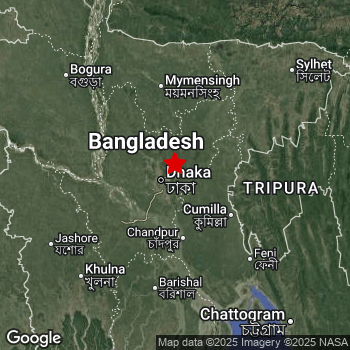 Map of area around epicenter. Click to open in Google Maps. |
| Magnitude: | MAG 5.4 Detected by 25 stations. Maximum Error Range ±0.062 . |
| Depth: | 27 km (17 mi) A quite shallow depth. |
| Max. Intensity: | VI
Strong On the Modified Mercalli Scale. |
| Tsunami Risk: | Tsunami very unlikely While this was a shallow earthquake in a coastal area, it appears to have occurred under land (19 km from the sea) with a magnitude that is usually not strong enough to cause tsunami's. Always stay cautious - More info here. |
Significant impact predicted
The US Geographic Survey (USGS) describes the impact of this earthquake as follows:
Eighty-five persons injured in Comilla; 4 persons killed and more than 20 injured in Dhaka; 400 injured in Gazipur; 1 person killed and at least 24 injured in Narayanganj; 5 persons killed and more than 100 injured in Narsingdi. At least 50 buildings damaged and power outages reported in the Chittagong-Dhaka area. Ground ruptures reported in the Ghorashal-Palash area.
Based on scientific estimates by the USGS, the risk of high fatalities for this earthquake is classified at level YELLOW (significant). They expect an 35% likelyhood of between 10 and 100 fatalities, and a 92% chance that the number of fatalities falls between 1 and 10,000.
The USGS classifies the economic impact of this earthquake at level YELLOW (significant). They expect an 35% likelyhood of between 10 and 100 million US Dollars in economic damage and impact, and a 94% chance that the economic impact of this earthquake falls no higher than 1,000 million USD.
Roughly 166 million people exposed to shaking
The USGS has published a report estimating the number of people exposed to this earthquake. Acoording to their analysis, roughly 166 million have been exposed to shaking at an MMI level of II or higher.
Strong shaking and probably light damage may have been experienced by an estimated 5,292,000 people. At VI, it is the highest MMI level this earthquake has caused. The majority of people (roughly 76 million) live in an area exposed to level IV, where light shaking and likely no damage is expected.
People in 2 countries have been exposed to shaking. Roughly 148 million people were exposed to shaking in Bangladesh , with level VI (strong shaking, probably light damage) as the highest recorded. In India , around 17 million people.
| People | MMI Level | Shaking | Damage |
|---|---|---|---|
| 0 | I |
Not noticable | None |
| 251,800 | II |
Very weak | None |
| 63,370,000 | III |
Weak | Probably none |
| 76,300,000 | IV |
Light | Likely none |
| 20,660,000 | V |
Moderate | Very light |
| 5,292,000 | VI |
Strong | Light |
| 0 | VII |
Very Strong | Moderate |
| 0 | VIII |
Severe | Moderate to heavy |
| 0 | IX |
Violent | Heavy |
| 0 | X |
Extreme | Very heavy |
Nearby towns and cities
2 countries can be found within 300km of the epicenter of this earthquake: Bangladesh and India .
Located 17 kilometer (11 mi) west-southwest of the epicenter of this earthquake, Narsingdi (Dhaka, Bangladesh) is the nearest significant population center. The intensity of shaking and damage in Narsingdi is estimated to be around level V on the Modified Mercalli Intensity scale (moderate shaking, very light damage).
Major cities near this earthquake: Dhaka is located 23 km to the southwest and experienced an intensity of V (moderate shaking, very light damage). Tungi is located 18 km to the west-northwest and experienced an intensity of V (moderate shaking, very light damage). Chattogram is located 212 km to the south-east and experienced an intensity of III (weak shaking, probably no damage).
A complete list of nearby places is included below. Estimated intensity data (MMI) sourced from a shake-map published by the US Geographic Survey is shown where available (cities without data probably experienced little impact).
Overview of nearby places
| Distance | Place | Intensity (MMI) |
|---|---|---|
| 17 km (11 mi) ENE from epicenter |
Narsingdi Dhaka, Bangladesh. |
V
Moderate |
| 18 km (11 mi) WNW from epicenter |
Tungi Dhaka, Bangladesh. |
V
Moderate |
| 21 km (13 mi) SW from epicenter |
Paltan Dhaka, Bangladesh. |
V
Moderate |
| 23 km (14 mi) SW from epicenter |
Dhaka Dhaka, Bangladesh. |
V
Moderate |
| 23 km (14 mi) SSE from epicenter |
Sonārgaon Dhaka, Bangladesh. |
V
Moderate |
| 24 km (15 mi) SW from epicenter |
Azimpur Dhaka, Bangladesh. |
V
Moderate |
| 28 km (17 mi) SSW from epicenter |
Nārāyanganj Dhaka, Bangladesh. |
VI
Strong |
| 40 km (25 mi) E from epicenter |
Nabīnagar Chittagong, Bangladesh. |
IV
Light |
| 42 km (26 mi) W from epicenter |
Joymontop Dhaka, Bangladesh. |
V
Moderate |
| 46 km (29 mi) ENE from epicenter |
Bhairab Bāzār Dhaka, Bangladesh. |
IV
Light |
| 53 km (33 mi) SW from epicenter |
Dohār Dhaka, Bangladesh. |
IV
Light |
| 55 km (34 mi) NE from epicenter |
Bājitpur Dhaka, Bangladesh. |
IV
Light |
| 55 km (34 mi) WNW from epicenter |
Mirzāpur Dhaka, Bangladesh. |
IV
Light |
| 64 km (40 mi) N from epicenter |
Gafargaon Mymensingh Division, Bangladesh. |
IV
Light |
| 66 km (41 mi) NW from epicenter |
Sakhipur Dhaka, Bangladesh. |
IV
Light |
| 68 km (42 mi) NNE from epicenter |
Kishorganj Dhaka, Bangladesh. |
IV
Light |
| 70 km (43 mi) SSW from epicenter |
Char Bhadrāsan Dhaka, Bangladesh. |
IV
Light |
| 72 km (45 mi) E from epicenter |
Agartala Tripura, India. |
IV
Light |
| 73 km (45 mi) SSE from epicenter |
Hājīganj Chittagong, Bangladesh. |
IV
Light |
| 74 km (46 mi) WNW from epicenter |
Nāgarpur Dhaka, Bangladesh. |
IV
Light |
| 74 km (46 mi) SSW from epicenter |
Pālang Dhaka, Bangladesh. |
IV
Light |
| 76 km (47 mi) SE from epicenter |
Comilla Chittagong, Bangladesh. |
IV
Light |
| 80 km (50 mi) WSW from epicenter |
Farīdpur Dhaka, Bangladesh. |
IV
Light |
| 80 km (50 mi) WNW from epicenter |
Tāngāil Dhaka, Bangladesh. |
IV
Light |
| 84 km (52 mi) ESE from epicenter |
Barjala Tripura, India. |
IV
Light |
| 85 km (53 mi) SSW from epicenter |
Madaripur Dhaka, Bangladesh. |
IV
Light |
| 88 km (55 mi) SE from epicenter |
Lākshām Chittagong, Bangladesh. |
IV
Light |
| 89 km (55 mi) SSE from epicenter |
Rāmganj Chittagong, Bangladesh. |
IV
Light |
| 93 km (58 mi) SSE from epicenter |
Rāipur Chittagong, Bangladesh. |
IV
Light |
| 99 km (62 mi) ESE from epicenter |
Udaipur Tripura, India. |
IV
Light |
| 99 km (62 mi) WNW from epicenter |
Bera Rajshahi Division, Bangladesh. |
IV
Light |
| 101 km (63 mi) N from epicenter |
Mymensingh Mymensingh Division, Bangladesh. |
IV
Light |
| 103 km (64 mi) NE from epicenter |
Habiganj Sylhet, Bangladesh. |
IV
Light |
| 105 km (65 mi) WNW from epicenter |
Shāhzādpur Rajshahi Division, Bangladesh. |
IV
Light |
| 110 km (68 mi) NW from epicenter |
Sirajganj Rajshahi Division, Bangladesh. |
IV
Light |
| 115 km (71 mi) N from epicenter |
Netrakona Mymensingh Division, Bangladesh. |
IV
Light |
| 130 km (81 mi) S from epicenter |
Barishal Barisāl, Bangladesh. |
IV
Light |
| 134 km (83 mi) NNW from epicenter |
Jamālpur Mymensingh Division, Bangladesh. |
IV
Light |
| 137 km (85 mi) W from epicenter |
Pābna Rajshahi Division, Bangladesh. |
IV
Light |
| 148 km (92 mi) W from epicenter |
Kushtia Khulna, Bangladesh. |
IV
Light |
| 155 km (96 mi) SW from epicenter |
Khulna Khulna, Bangladesh. |
IV
Light |
| 155 km (96 mi) SSW from epicenter |
Bagerhat Khulna, Bangladesh. |
IV
Light |
| 158 km (98 mi) WSW from epicenter |
Jessore Khulna, Bangladesh. |
IV
Light |
| 164 km (102 mi) NW from epicenter |
Bogra Rajshahi Division, Bangladesh. |
III
Weak |
| 172 km (107 mi) WNW from epicenter |
Natore Rajshahi Division, Bangladesh. |
III
Weak |
| 175 km (109 mi) NE from epicenter |
Sylhet Sylhet, Bangladesh. |
III
Weak |
| 179 km (111 mi) NW from epicenter |
Shibganj Rajshahi Division, Bangladesh. |
III
Weak |
| 188 km (117 mi) NNW from epicenter |
Tura Meghalaya, India. |
III
Weak |
| 208 km (129 mi) WNW from epicenter |
Rājshāhi Rajshahi Division, Bangladesh. |
|
| 212 km (132 mi) SE from epicenter |
Chattogram Chittagong, Bangladesh. |
III
Weak |
| 219 km (136 mi) E from epicenter |
Aizawl Mizoram, India. |
|
| 249 km (155 mi) NNW from epicenter |
Rangpur Rangpur Division, Bangladesh. |
|
| 268 km (167 mi) WSW from epicenter |
Kolkata West Bengal, India. |
|
| 271 km (168 mi) WSW from epicenter |
Hāora West Bengal, India. |
|
| 285 km (177 mi) NNE from epicenter |
Guwahati Assam, India. |
|
| 290 km (180 mi) WNW from epicenter |
Pakur Jharkhand, India. |
Earthquake Intensity Map
The intensity in shaking and damage by this earthquake is illustrated through the map below. The highest intensity measured for this earthquake is VI.

Shaking reported by 965 people in 3 countries
People that feel an earthquake may report their experience to the US Geographic Survey. Currently, 965 people have reported shaking in 72 places in 3 countries (Bangladesh, India, Bhutan).We keep updating this article as more ground reports become available. You may report that you felt this earthquake here.
Places with most reports:
- Dacca, Dhāka, Bangladesh: 419 people.
- Ţungī, Gazipur, Bangladesh: 289 people.
- Narayanganj, Nārāyanganj, Bangladesh: 41 people.
- Dhamrai, Dhāka, Bangladesh: 24 people.
- Calcutta, Bangla, India: 19 people.
- Narsingdi, Narsingdi, Bangladesh: 14 people.
- Comilla, Komīllā, Bangladesh: 14 people.
- Gajipur, Gazipur, Bangladesh: 12 people.
- Rajshahi, Rājshāhī, Bangladesh: 11 people.
- Chattagam, Chāţţagām, Bangladesh: 8 people.
2 Aftershocks detected
Since this main shock, 2 smaller aftershocks were detected. Just 1 day after this main shock, an earthquake measuring MAG-4.3 was detected 6 km (4 mi) southwest of this earthquake.
Overview of foreshocks and aftershocks
| Classification | Magnitude | When | Where |
|---|---|---|---|
| Main Shock This Earthquake |
M 5.4 |
Nov 21, 2025 10:38AM (Dhaka Time) | - |
| Aftershock | M 3.3 |
24 hrs later Nov 22, 2025 10:36AM (Dhaka Time) | 12 km (7 mi) N from Main Shock. |
| Aftershock | M 4.3 |
1 day later Nov 22, 2025 06:06PM (Dhaka Time) | 6 km (4 mi) SW from Main Shock. |
More earthquakes coming?
The risk of aftershocks decreases rapidly over time. Usually, aftershocks are at least one order of magnitude lower than a main shock.
In only six percent of cases, significant earthquakes are followed by a larger main shock, making the current earthquake a foreshock. While the chance of this happening is not so large, it is adviced to maintain cautiousness in the hours and days following a major earthquake.
Read: How to Stay Safe during an Earthquake (cdc.gov).Earthquakes like this are common in the region
Earthquakes of this strength occur quite regularly in the region. This is the strongest earthquake to hit since December 2nd, 2023, when a 5.5 magnitude earthquake hit 87 km (54 mi) further south-southeast. An even stronger magnitude 5.7 earthquake struck on January 3rd, 2017.
In total, 3 earthquakes with a magnitude of 5.4 or higher have been registered within 300km (186 mi) of this epicenter in the past 10 years. This comes down to an average of once every 3 years.
Tsunami very unlikely
While MAG-6.5+ earthquakes may cause tsunami's, it appears that the epicenter of this earthquake hit under land. In addition, the reported depth is deeper than 100km, making the risk of a tsunami even less likely. However always stay cautious and monitor advice from local authorities.
Tsunami Risk Factors
| Factor | Under Sea? | MAG-6.5 or stronger? | Shallow depth? |
|---|---|---|---|
| Explanation | Almost all tsunami's are caused by earthquakes with their epicenter under sea or very near the sea. However stay cautious in coastal areas as earthquakes on land may cause landslides into sea, potentially still causing a local tsunami. | Under MAG 6.5: Very unlikely to cause a tsunami. MAG 6.5 to 7.5: Destructive tsunami's do occur, but are uncommon. Likely to observe small sea level changes. MAG 7.6+: Earthquakes with these magnitudes might produce destructive tsunami's. |
Most destructive tsunami's are caused by shallow earthquakes with a depth between 0 and 100km under the surface of the earth. Deeper tsunami's are unlikely to displace to ocean floor. |
| This Earthquake | This earthquake appears to have struck on land near a coastal area (19 km from the sea). | Not this earthquake. This earthquake had a magnitude of 5.4. Earthquakes of this strength are unlikely to trigger a tsunami. |
This earthquake occurred at a depth of of 27 km (17 mi). Earthquakes this shallow could trigger a tsunami. |
Sources
Last updated 19/01/26 06:58 (). This article is automatically generated based on available data. We keep checking multiple sources for additional information. This article gets updated as new details on this earthquake become available.
- US Geographic Society (USGS): Earthquake us6000rpht
- European-Mediterranean Seismological Centre (EMSC): Earthquake 20251121_0000065
- Geonames.org: World Cities Database
- Google Maps: Static API
- Earthquakelist.org: Historic Earthquakes Database
Share this article:
