Latest earthquakes near Dominican Republic today
Complete overview of the latest earthquakes near the country Dominican Republic, updated every minute. Did you feel an earthquake today in Dominican Republic? If an earthquake is happening right now near Dominican Republic, it will show up within minutes.
Recent Dominican Republic Earthquake News
These are the latest articles published related to earthquakes occurring near Dominican Republic. Check our Earthquake News section for a complete overview of articles written on earthquakes near Dominican Republic and elsewhere.
 Mar 17, 2026 12:28AM
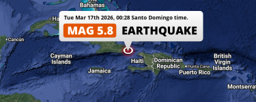
Shallow M5.8 Earthquake hit in the Caribbean Sea near Guantánamo (Cuba) on Tuesday Night.
Mar 17, 2026 12:28AM
Shallow M5.8 Earthquake hit in the Caribbean Sea near Guantánamo (Cuba) on Tuesday Night.
 Jun 23, 2025 10:45PM
On Monday Evening a Significant M5.7 Earthquake struck in the North Atlantic Ocean near Punta Cana (Dominican Republic).
Jun 23, 2025 10:45PM
On Monday Evening a Significant M5.7 Earthquake struck in the North Atlantic Ocean near Punta Cana (Dominican Republic).
Dominican Republic Earthquake Statistics
Average
A total of 713 earthquakes with a magnitude of four or above have struck within 300 km (186 mi) of Dominican Republic in the past 10 years. This comes down to a yearly average of 71 earthquakes per year, or 5 per month. On average an earthquake will hit near Dominican Republic roughly every 5 days.
A relatively large number of earthquakes occurred near Dominican Republic in 2020. A total of 164 earthquakes (mag 4+) were detected within 300 km of Dominican Republic that year. The strongest had a 6.4 magnitude.

Magnitude Distribution
The table below visualizes the distribution of all earthquakes that occurred within 300km of Dominican Republic in the past 10 years. No earthquakes with a magnitude of 7 or above have occurred near Dominican Republic during this time. Usually, higher magnitudes are less common than lower magnitudes. Small earthquakes with a magnitude below 4 on the Richter scale have been omitted from this overview.
| Magnitude | Earthquakes | Percentage |
|---|---|---|
| Mag. 4 | 670 | 93.97% |
| Mag. 5 | 41 | 5.75% |
| Mag. 6 | 2 | 0.28% |
| Mag. 7 | 0 | 0.0% |
| Mag. 8 | 0 | 0.0% |
| Mag. 9 | 0 | 0.0% |
| Mag. 10 | 0 | 0.0% |
Strongest earthquakes near Dominican Republic
The strongest recent earthquake of the past 10 years near Dominican Republic occurred on Jan 7, 2020 04:24 local time (America/Santo_Domingo timezone). It had a magnitude of 6.4 and struck 182 kilometers (113 mi) east-southeast of Punta Cana, at a depth of 6 km. Discover more strong earthquakes near Dominican Republic in the list below.
A longer time ago, a MAG-7.8 earthquake struck on Aug 4, 1946 12:51, 78 kilometers (48 mi) east-southeast of San Pedro de Macorís. It is the strongest earthquake near Dominican Republic in the past 126 years (Our data goes back to January 1st, 1900).
In the table below you will find the strongest earthquakes that occurred near Dominican Republic in the past 10 years. You can use the tabs to find the heaviest historic earthquakes since the year 1900 or within a specific year or distance from Dominican Republic.
Earthquakes by region of Dominican Republic
Click the links below for earthquake reports for regions in Dominican Republic.
- Azua
- Baoruco
- Barahona
- Dajabón
- Duarte
- El Seíbo
- Espaillat
- Hato Mayor
- Hermanas Mirabal
- La Altagracia
- La Romana
- La Vega
- María Trinidad Sánchez
- Monseñor Nouel
- Monte Cristi
- Monte Plata
- Nacional (Distrito de Santo Domingo)
- Peravia
- Puerto Plata
- San Cristóbal
- San José de Ocoa
- San Juan
- San Pedro de Macorís
- Santiago
- Santiago Rodríguez
- Santo Domingo
- Sánchez Ramírez
- Valverde
Frequently Asked Questions
These questions are commonly asked in relation to earthquakes occurring near Dominican Republic.
When was the last earthquake in Dominican Republic?
A 2.3 magnitude earthquake hit near Dominican Republic on the night of April 19, 2026 at 02:30 local time (America/Santo_Domingo). The center of this earthquake was located 167km south-east of Punta Cana at a depth of 10km under land. Check the list on our website for any earthquakes occurring near Dominican Republic in the past hours.
What was the strongest earthquake near Dominican Republic?
A 7.8 magnitude earthquake hit near Dominican Republic on the afternoon of August 4, 1946 at 12:51 local time (America/Santo_Domingo). The center of this earthquake was located 78km north-northeast of San Pedro de Macorís at a depth of 15km under water in the North Atlantic Ocean. This is the strongest earthquake that occurred near Dominican Republic since the year 1900.
How often do earthquakes occur near Dominican Republic?
In the past 10 years, 713 earthquakes with a magnitude of four or higher occurred within a 300 kilometer range from Dominican Republic. This averages to 71 earthquakes yearly, or one earthquake every 5 days.
