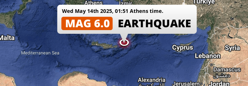
In the night of Wednesday May 14th, 2025, a strong M6.0 earthquake hit in the Mediterranean Sea, Eastern Basin 168 kilometer from Irákleion, Greece. Around 1.1 million people have been exposed to shaking. Türkiye is also near its epicenter.
Felt the earthquake? Share this article: 


Earthquake Summary
This earthquake hit under water in the Mediterranean Sea, Eastern Basin, 25 kilometers (16 mi) off the coast of Greece, 168 kilometer east of Irákleion in Crete. The center of this earthquake had an intermediate depth of 74 km.
| Date and Time: | May 14, 2025 01:51 (Athens Time) - May 13, 2025 22:51 Universal Time. |
|---|---|
| Location: | 168 km east of Irákleion, Crete, Greece. Coordinates 35°13'53"N 26°59'32"E. |
| Map: | 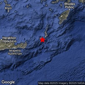 Map of area around epicenter. Click to open in Google Maps. |
| Magnitude: | MAG 6.0 Detected by 80 stations. Maximum Error Range ±0.035 . |
| Depth: | 74 km (46 mi) An intermediate depth. |
| Max. Intensity: | VII
Very Strong On the Modified Mercalli Scale. |
| Tsunami Risk: | Low tsunami risk Earthquakes under MAG-6.5 do not usually cause tsunami's. Always stay cautious - More info here. |
Minimal impact predicted
Based on scientific estimates by the US Geographic Survey (USGS), the risk of high fatalities for this earthquake is classified at level GREEN (low). They expect an 65% likelyhood of between 0 and 1 fatalities, and a 96% chance that the number of fatalities falls no higher than 10.
The USGS classifies the economic impact of this earthquake at level GREEN (low). They expect an 100% likelyhood of between 0 and 1 million US Dollars in economic damage and impact.
Roughly 1.1 million people exposed to shaking
This earthquake may have been felt by around 1.1 million people. That is the expected population size of the area exposed to a level of shaking of II or higher on the Modified Mercalli scale according to the USGS.
Strong shaking and probably light damage may have been experienced by an estimated 3,540 people. At VI, it is the highest MMI level this earthquake has caused. The majority of people (roughly 710 thousand) live in an area exposed to level IV, where light shaking and likely no damage is expected.
People in 2 countries have been exposed to shaking. In Greece , around 570 thousand people, with impact levels up to VI (strong shaking, probably light damage). In Türkiye , around 480 thousand people.
| People | MMI Level | Shaking | Damage |
|---|---|---|---|
| 0 | I |
Not noticable | None |
| 0 | II |
Very weak | None |
| 334,500 | III |
Weak | Probably none |
| 712,200 | IV |
Light | Likely none |
| 5,900 | V |
Moderate | Very light |
| 3,540 | VI |
Strong | Light |
| 0 | VII |
Very Strong | Moderate |
| 0 | VIII |
Severe | Moderate to heavy |
| 0 | IX |
Violent | Heavy |
| 0 | X |
Extreme | Very heavy |
Nearby towns and cities
Greece and Türkiye are both located within 300km distance of the epicenter of the earthquake.
The closest significant population center near the earthquake is Irákleion in Crete, Greece. Irákleion is located 168 kilometer (104 mi) east of the epicenter. The intensity of shaking and damage in Irákleion is estimated to be around level IV on the Modified Mercalli Intensity scale (light shaking, likely no damage).
Major cities near this earthquake: İzmir is located 354 km to the north (intensity unknown, possibly low). Antalya is located 381 km to the east-northeast (intensity unknown, possibly low). Karabağlar is located 350 km to the north (intensity unknown, possibly low).
An overview of nearby towns and cities is available in the overview below. If places don't have intensity data available, it likely means the experienced impact in those places was fairly small.
Overview of nearby places
| Distance | Place | Intensity (MMI) |
|---|---|---|
| 168 km (104 mi) W from epicenter |
Irákleion Crete, Greece. |
IV
Light |
| 174 km (108 mi) NE from epicenter |
Ródos South Aegean, Greece. |
IV
Light |
| 187 km (116 mi) N from epicenter |
Kos South Aegean, Greece. |
IV
Light |
| 200 km (124 mi) N from epicenter |
Turgutreis Muğla, Türkiye. |
III
Weak |
| 205 km (127 mi) N from epicenter |
Bodrum Muğla, Türkiye. |
|
| 214 km (133 mi) NNE from epicenter |
Marmaris Muğla, Türkiye. |
IV
Light |
| 226 km (140 mi) NE from epicenter |
Sarigerme Muğla, Türkiye. |
IV
Light |
| 228 km (142 mi) W from epicenter |
Rethymno Crete, Greece. |
|
| 236 km (147 mi) NE from epicenter |
Dalaman Muğla, Türkiye. |
IV
Light |
| 239 km (149 mi) NE from epicenter |
Ortaca Muğla, Türkiye. |
IV
Light |
| 241 km (150 mi) N from epicenter |
Didim Aydın, Türkiye. |
|
| 242 km (150 mi) NNE from epicenter |
Milas Muğla, Türkiye. |
|
| 248 km (154 mi) NE from epicenter |
Fethiye Muğla, Türkiye. |
III
Weak |
| 253 km (157 mi) NNE from epicenter |
Muğla Muğla, Türkiye. |
|
| 256 km (159 mi) NNE from epicenter |
Yatağan Muğla, Türkiye. |
|
| 270 km (168 mi) W from epicenter |
Chaniá Crete, Greece. |
|
| 281 km (175 mi) NNE from epicenter |
Çine Aydın, Türkiye. |
|
| 282 km (175 mi) N from epicenter |
Söke Aydın, Türkiye. |
|
| 293 km (182 mi) N from epicenter |
Kuşadası Aydın, Türkiye. |
|
| 299 km (186 mi) NNE from epicenter |
İncirliova Aydın, Türkiye. |
|
| 300 km (186 mi) NNE from epicenter |
Aydın Aydın, Türkiye. |
|
| 304 km (189 mi) N from epicenter |
Selçuk İzmir, Türkiye. |
|
| 312 km (194 mi) ENE from epicenter |
Elmalı Antalya, Türkiye. |
|
| 321 km (199 mi) NNE from epicenter |
Nazilli Aydın, Türkiye. |
|
| 322 km (200 mi) ENE from epicenter |
Beykonak Antalya, Türkiye. |
|
| 325 km (202 mi) N from epicenter |
Tire İzmir, Türkiye. |
|
| 326 km (203 mi) N from epicenter |
Torbalı İzmir, Türkiye. |
|
| 330 km (205 mi) N from epicenter |
Seferihisar İzmir, Türkiye. |
|
| 331 km (206 mi) NE from epicenter |
Serinhisar Denizli, Türkiye. |
|
| 336 km (209 mi) N from epicenter |
Menderes İzmir, Türkiye. |
|
| 339 km (211 mi) NNE from epicenter |
Denizli Denizli, Türkiye. |
|
| 340 km (211 mi) NNE from epicenter |
Merkezefendi Denizli, Türkiye. |
|
| 344 km (214 mi) N from epicenter |
Urla İzmir, Türkiye. |
|
| 344 km (214 mi) NNE from epicenter |
Ödemiş İzmir, Türkiye. |
|
| 346 km (215 mi) NNE from epicenter |
Sarayköy Denizli, Türkiye. |
|
| 348 km (216 mi) ENE from epicenter |
Tekirova Antalya, Türkiye. |
|
| 349 km (217 mi) N from epicenter |
Çeşme İzmir, Türkiye. |
|
| 350 km (217 mi) N from epicenter |
Karabağlar İzmir, Türkiye. |
|
| 353 km (219 mi) NE from epicenter |
Korkuteli Antalya, Türkiye. |
|
| 354 km (220 mi) N from epicenter |
İzmir İzmir, Türkiye. |
|
| 357 km (222 mi) NNW from epicenter |
Chios North Aegean, Greece. |
|
| 357 km (222 mi) N from epicenter |
Kemalpaşa İzmir, Türkiye. |
|
| 368 km (229 mi) N from epicenter |
Turgutlu Manisa, Türkiye. |
|
| 372 km (231 mi) NNE from epicenter |
Alaşehir Manisa, Türkiye. |
|
| 375 km (233 mi) N from epicenter |
Menemen İzmir, Türkiye. |
|
| 376 km (234 mi) NNE from epicenter |
Salihli Manisa, Türkiye. |
|
| 378 km (235 mi) N from epicenter |
Manisa Manisa, Türkiye. |
|
| 381 km (237 mi) ENE from epicenter |
Antalya Antalya, Türkiye. |
|
| 386 km (240 mi) ENE from epicenter |
Muratpaşa Antalya, Türkiye. |
|
| 397 km (247 mi) NNE from epicenter |
Kula Manisa, Türkiye. |
|
| 397 km (247 mi) N from epicenter |
Aliağa İzmir, Türkiye. |
Earthquake Intensity Map
The maximum intensity (MMI Scale) caused by this earthquake is VI. The map below shows in which areas this earthquake was the most and least impactful. It is based on data from the US Geographic Survey.

Shaking reported by 918 people in 12 countries
People that feel an earthquake may report their experience to the US Geographic Survey. Currently, 918 people have reported shaking in 161 places in 12 countries (Cyprus, Saudi Arabia, Syria, Turkey, Egypt, Greece, Israel, Jordan, Lebanon, Macedonia, Malta, Palestine).We keep updating this article as more ground reports become available. You may report that you felt this earthquake here.
Places with most reports:
- Cairo, Kairo, Egypt: 182 people.
- Alexandria, Alexandria, Egypt: 73 people.
- Gizeh, Giseh, Egypt: 58 people.
- El Khanka, al-Qalyūbiyah, Egypt: 45 people.
- Kárpathos, Dodekánisos, Greece: 29 people.
- Iráklion, Iráklion, Greece: 25 people.
- Shubra-El-Khema, al-Qalyūbiyah, Egypt: 23 people.
- Madīnat Sittah Uktūbar, Giseh, Egypt: 22 people.
- El Qoseyia, Assiut, Egypt: 20 people.
- El Asher men Ramadan, aš-Šarqīyah, Egypt: 19 people.
6 Aftershocks detected
Since this main shock, 6 smaller aftershocks were detected. Just 3 days after this main shock, an earthquake measuring MAG-3.5 was detected 24 km (15 mi) north-east of this earthquake.
Before this earthquake struck, 3 smaller foreshocks occurred. Roughly 15 hrs before this earthquake, a foreshock measuring MAG-3.6 was detected nearby this earthquake.
Overview of foreshocks and aftershocks
| Classification | Magnitude | When | Where |
|---|---|---|---|
| Foreshock | M 2.7 |
3 days earlier May 11, 2025 08:13 (Athens Time) | 85 km (53 mi) NW from Main Shock. |
| Foreshock | M 3.6 |
15 hrs earlier May 13, 2025 11:19 (Athens Time) | 38 km (24 mi) NNE from Main Shock. |
| Foreshock | M 2.5 |
12 hrs earlier May 13, 2025 13:34 (Athens Time) | 31 km (19 mi) ENE from Main Shock. |
| Main Shock This Earthquake |
M 6.0 |
May 14, 2025 01:51 (Athens Time) | - |
| Aftershock | M 2.6 |
2 hrs later May 14, 2025 03:30 (Athens Time) | 37 km (23 mi) NNW from Main Shock. |
| Aftershock | M 3.4 |
2 hrs later May 14, 2025 03:57 (Athens Time) | 13 km (8 mi) SSE from Main Shock. |
| Aftershock | M 2.5 |
1 day later May 15, 2025 12:54 (Athens Time) | 34 km (21 mi) N from Main Shock. |
| Aftershock | M 2.5 |
2 days later May 16, 2025 09:06 (Athens Time) | 40 km (25 mi) ENE from Main Shock. |
| Aftershock | M 3.5 |
3 days later May 16, 2025 15:40 (Athens Time) | 24 km (15 mi) NE from Main Shock. |
| Aftershock | M 2.6 |
3 days later May 16, 2025 17:42 (Athens Time) | 18 km (11 mi) ENE from Main Shock. |
More earthquakes coming?
Earthquakes can create aftershocks. These are generally at least 1 magnitude lower than any main shock, and as time passes the chance and strength of aftershocks decreases.
It's always adviced to be cautious of the risk of a larger shock following any significant earthquake, however this risk is fairly small. There is a roughly 94 percent change that no larger main shock will follow in the days following this earthquake.
Read: How to Stay Safe during an Earthquake (cdc.gov).This is the strongest earthquake in 4 years
Earthquakes of this strength occur quite regularly in the region. This is the strongest earthquake to hit since October 12th, 2021, when a 6.4 magnitude earthquake hit 71 km (44 mi) further west. An even stronger magnitude 7 earthquake struck on October 30th, 2020.
In total, 5 earthquakes with a magnitude of 6 or higher have been registered within 300km (186 mi) of this epicenter in the past 10 years. This comes down to an average of once every 2 years.
Low tsunami risk
Based on early data it appears this earthquake was not strong enough (lower than MAG-6.5) to be likely to cause destructive tsunami's. However this earthquake appeared to have hit at a shallow depth under sea, so stay cautious and monitor advice from local authorities.
Tsunami Risk Factors
| Factor | Under Sea? | MAG-6.5 or stronger? | Shallow depth? |
|---|---|---|---|
| Explanation | Almost all tsunami's are caused by earthquakes with their epicenter under sea or very near the sea. However stay cautious in coastal areas as earthquakes on land may cause landslides into sea, potentially still causing a local tsunami. | Under MAG 6.5: Very unlikely to cause a tsunami. MAG 6.5 to 7.5: Destructive tsunami's do occur, but are uncommon. Likely to observe small sea level changes. MAG 7.6+: Earthquakes with these magnitudes might produce destructive tsunami's. |
Most destructive tsunami's are caused by shallow earthquakes with a depth between 0 and 100km under the surface of the earth. Deeper tsunami's are unlikely to displace to ocean floor. |
| This Earthquake | This earthquake appears to have struck under the sea. | Not this earthquake. This earthquake had a magnitude of 6. Earthquakes of this strength are unlikely to trigger a tsunami. |
This earthquake occurred at a depth of of 74 km (46 mi). Earthquakes this shallow could trigger a tsunami. |
Sources
Last updated 12/07/25 07:28 (). This article is automatically generated based on available data. We keep checking multiple sources for additional information. This article gets updated as new details on this earthquake become available.
- US Geographic Society (USGS): Earthquake us7000pz2p
- European-Mediterranean Seismological Centre (EMSC): Earthquake 20250513_0000292
- Geonames.org: World Cities Database
- Google Maps: Static API
- Earthquakelist.org: Historic Earthquakes Database
Share this article:
