In the morning of Monday April 14th, 2025, a shallow and significant MAG-5.2 earthquake hit under land 40 miles from San Diego in The United States. The earthquake struck near a very densely populated region. The USGS has indicated there is a potential risk at tsunami's following this earthquake. Mexico is also near its epicenter.
Felt the earthquake? Share this article: 


Earthquake Summary
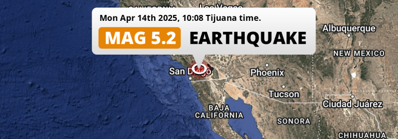
The earthquake struck on land in The United States, 40 miles (64 km) north-east of San Diego in California. The center of this earthquake had a very shallow depth of 9 km. Shallow earthquakes usually have a larger impact than earthquakes deep in the earth.
| Date and Time: | Apr 14, 2025 10:08AM (Los Angeles Time) - Apr 14, 2025 17:08 Universal Time. |
|---|---|
| Location: | 40 mi NE of San Diego, California, The United States. Coordinates 33°2'9"N 116°35'41"W. |
| Map: |  Map of area around epicenter. Click to open in Google Maps. |
| Magnitude: | MAG 5.2 Detected by 14 stations. Maximum Error Range ±0.2 . |
| Depth: | 9 mi (14 km) A very shallow depth. |
| Max. Intensity: | VII
Very Strong On the Modified Mercalli Scale. |
| Tsunami Risk: | Potential tsunami risk The USGS has indicated there is a potential risk at tsunami's following this earthquake. Always stay cautious - More info here. |
Potential tsunami risk
There is a potential tsunami risk in the aftermath of this earthquake, immediately evacuate to higher grounds away from coastal areas and monitor advice from local authorities. The US Geographic Survey organization has indicated a potential risk for tsunami's following this earthquake.
Tsunami Risk Factors
| Factor | Under Sea? | MAG-6.5 or stronger? | Shallow depth? |
|---|---|---|---|
| Explanation | Almost all tsunami's are caused by earthquakes with their epicenter under sea or very near the sea. However stay cautious in coastal areas as earthquakes on land may cause landslides into sea, potentially still causing a local tsunami. | Under MAG 6.5: Very unlikely to cause a tsunami. MAG 6.5 to 7.5: Destructive tsunami's do occur, but are uncommon. Likely to observe small sea level changes. MAG 7.6+: Earthquakes with these magnitudes might produce destructive tsunami's. |
Most destructive tsunami's are caused by shallow earthquakes with a depth between 0 and 100km under the surface of the earth. Deeper tsunami's are unlikely to displace to ocean floor. |
| This Earthquake | Not this earthquake. This earthquake appears to have struck on land far from any coast. |
Not this earthquake. This earthquake had a magnitude of 5.2. Earthquakes of this strength are unlikely to trigger a tsunami. |
This earthquake occurred at a depth of of 9 mi (14 km). Earthquakes this shallow could trigger a tsunami. |
Minimal impact predicted
Based on scientific estimates by the US Geographic Survey (USGS), the risk of high fatalities for this earthquake is classified at level GREEN (low). They expect an 65% likelyhood of between 0 and 1 fatalities, and a 96% chance that the number of fatalities falls no higher than 10.
The USGS classifies the economic impact of this earthquake at level GREEN (low). They expect an 100% likelyhood of between 0 and 1 million US Dollars in economic damage and impact.
Roughly 26 million people exposed to shaking
An estimated 26 million have been exposed to shaking (An MMI or Modified Mercalli Intensity level II or higher) as a result of this earthquake according scientific estimates published by the USGS.
Strong shaking and probably light damage may have been experienced by an estimated 8,700 people. At VI, it is the highest MMI level this earthquake has caused. Intensity level III was experienced by a large group of people (around 11 million). In their region, weak shaking and probably no damage can be expected. All exposure to shaking was within the borders of Mexico .
| People | MMI Level | Shaking | Damage |
|---|---|---|---|
| 5,980 | I |
Not noticable | None |
| 6,982,000 | II |
Very weak | None |
| 10,840,000 | III |
Weak | Probably none |
| 7,651,000 | IV |
Light | Likely none |
| 279,100 | V |
Moderate | Very light |
| 8,700 | VI |
Strong | Light |
| 0 | VII |
Very Strong | Moderate |
| 0 | VIII |
Severe | Moderate to heavy |
| 0 | IX |
Violent | Heavy |
| 0 | X |
Extreme | Very heavy |
Nearby towns and cities
This earthquake struck within proximity of multiple countries. The United States and Mexico are both within 300km distance of its epicenter.
Ramona in California, The United States is the nearest significant place from the epicenter. The earthquake occurred 16 miles (25 km) east of Ramona. The intensity of shaking and damage in Ramona is estimated to be around level V on the Modified Mercalli Intensity scale (moderate shaking, very light damage).
Major cities near this earthquake: San Diego is located 40 mi to the southwest and experienced an intensity of IV (light shaking, likely no damage). Los Angeles is located 118 mi to the northwest and experienced an intensity of II (very weak shaking, no damage). Tijuana is located 71 km to the south-southwest and experienced an intensity of IV (light shaking, likely no damage).
A complete list of nearby places is included below. Estimated intensity data (MMI) sourced from a shake-map published by the US Geographic Survey is shown where available (cities without data probably experienced little impact).
Overview of nearby places
| Distance | Place | Intensity (MMI) |
|---|---|---|
| 16 mi (25 km) W from epicenter |
Ramona California, The United States. |
V
Moderate |
| 22 mi (36 km) SW from epicenter |
Lakeside California, The United States. |
V
Moderate |
| 24 mi (39 km) SW from epicenter |
Winter Gardens California, The United States. |
V
Moderate |
| 25 mi (41 km) SW from epicenter |
Bostonia California, The United States. |
V
Moderate |
| 26 mi (42 km) WSW from epicenter |
Santee California, The United States. |
V
Moderate |
| 26 mi (42 km) WSW from epicenter |
Poway California, The United States. |
IV
Light |
| 27 mi (44 km) SW from epicenter |
El Cajon California, The United States. |
V
Moderate |
| 28 mi (45 km) SW from epicenter |
Rancho San Diego California, The United States. |
V
Moderate |
| 29 mi (46 km) SW from epicenter |
Casa de Oro-Mount Helix California, The United States. |
IV
Light |
| 29 mi (47 km) W from epicenter |
Escondido California, The United States. |
IV
Light |
| 30 mi (49 km) W from epicenter |
Rancho Penasquitos California, The United States. |
IV
Light |
| 31 mi (50 km) SW from epicenter |
Spring Valley California, The United States. |
IV
Light |
| 31 mi (50 km) SW from epicenter |
La Mesa California, The United States. |
IV
Light |
| 32 mi (52 km) SW from epicenter |
Lemon Grove California, The United States. |
IV
Light |
| 32 mi (52 km) SW from epicenter |
La Presa California, The United States. |
IV
Light |
| 52 km (32 mi) S from epicenter |
Tecate Baja California, Mexico. |
IV
Light |
| 33 mi (53 km) WSW from epicenter |
Mira Mesa California, The United States. |
IV
Light |
| 34 mi (55 km) WNW from epicenter |
San Marcos California, The United States. |
IV
Light |
| 39 mi (62 km) SW from epicenter |
National City California, The United States. |
IV
Light |
| 39 mi (63 km) WNW from epicenter |
Vista California, The United States. |
IV
Light |
| 39 mi (63 km) SW from epicenter |
Chula Vista California, The United States. |
IV
Light |
| 40 mi (64 km) SW from epicenter |
San Diego California, The United States. |
IV
Light |
| 65 km (40 mi) SSW from epicenter |
Terrazas del Valle Baja California, Mexico. |
IV
Light |
| 40 mi (65 km) W from epicenter |
Encinitas California, The United States. |
III
Weak |
| 42 mi (67 km) WSW from epicenter |
La Jolla California, The United States. |
IV
Light |
| 42 mi (67 km) SW from epicenter |
Coronado California, The United States. |
IV
Light |
| 43 mi (70 km) SW from epicenter |
Imperial Beach California, The United States. |
IV
Light |
| 71 km (44 mi) SSW from epicenter |
Tijuana Baja California, Mexico. |
IV
Light |
| 45 mi (72 km) WNW from epicenter |
Fallbrook California, The United States. |
IV
Light |
| 45 mi (72 km) NW from epicenter |
Temecula California, The United States. |
IV
Light |
| 45 mi (72 km) W from epicenter |
Carlsbad California, The United States. |
III
Weak |
| 47 mi (75 km) WNW from epicenter |
Oceanside California, The United States. |
IV
Light |
| 47 mi (75 km) NNE from epicenter |
La Quinta California, The United States. |
IV
Light |
| 76 km (47 mi) SSW from epicenter |
Rancho La Gloria Baja California, Mexico. |
IV
Light |
| 78 km (48 mi) SSW from epicenter |
Pórticos de San Antonio Baja California, Mexico. |
IV
Light |
| 49 mi (79 km) NNE from epicenter |
Palm Desert California, The United States. |
IV
Light |
| 50 mi (81 km) NW from epicenter |
Murrieta California, The United States. |
IV
Light |
| 51 mi (82 km) NNE from epicenter |
Coachella California, The United States. |
IV
Light |
| 52 mi (84 km) N from epicenter |
Cathedral City California, The United States. |
IV
Light |
| 52 mi (84 km) NNE from epicenter |
Indio California, The United States. |
IV
Light |
| 86 km (53 mi) SSW from epicenter |
Rosarito Baja California, Mexico. |
IV
Light |
| 54 mi (87 km) NNW from epicenter |
Hemet California, The United States. |
IV
Light |
| 55 mi (88 km) N from epicenter |
Palm Springs California, The United States. |
IV
Light |
| 55 mi (89 km) NW from epicenter |
Wildomar California, The United States. |
IV
Light |
| 56 mi (90 km) NNW from epicenter |
San Jacinto California, The United States. |
IV
Light |
| 57 mi (92 km) NW from epicenter |
Menifee California, The United States. |
IV
Light |
| 61 mi (98 km) NW from epicenter |
Lake Elsinore California, The United States. |
III
Weak |
| 62 mi (100 km) ESE from epicenter |
El Centro California, The United States. |
III
Weak |
| 116 km (72 mi) ESE from epicenter |
Mexicali Baja California, Mexico. |
IV
Light |
| 78 mi (126 km) NW from epicenter |
Riverside California, The United States. |
III
Weak |
| 182 km (113 mi) ESE from epicenter |
San Luis Río Colorado Sonora, Mexico. |
III
Weak |
| 116 mi (187 km) E from epicenter |
Yuma Arizona, The United States. |
II
Weak |
| 118 mi (190 km) NW from epicenter |
Los Angeles California, The United States. |
II
Weak |
Earthquake Intensity Map
The intensity in shaking and damage by this earthquake is illustrated through the map below. The highest intensity measured for this earthquake is VI.

Shaking reported by 120 people
People that feel an earthquake may report their experience to the US Geographic Survey. Currently, 120 people have reported shaking in 12 places, all within Mexico.We keep updating this article as more ground reports become available. You may report that you felt this earthquake here.
Places with most reports:
- Tijuana, Baja California, Mexico: 47 people.
- La Joya, Baja California, Mexico: 33 people.
- Mexicali, Baja California, Mexico: 10 people.
- Rosarito, Baja California, Mexico: 6 people.
- Maneadero, Baja California, Mexico: 5 people.
- Puebla, Baja California, Mexico: 5 people.
- Ensenada, Baja California, Mexico: 4 people.
- Primo Tapia, Baja California, Mexico: 4 people.
- El Sauzal, Baja California, Mexico: 2 people.
- Tecate, Baja California, Mexico: 2 people.
12 Aftershocks detected
After this earthquake struck, 12 smaller aftershocks occurred. Just 1 hr after this main shock, an earthquake measuring MAG-4 was detected 0.4 mi (0.6 km) north-northeast of this earthquake.
This main shock was prefaced by 1 smaller foreshock. Roughly 18 hrs before this earthquake, a foreshock measuring MAG-3.3 was detected nearby this earthquake.
Overview of foreshocks and aftershocks
| Classification | Magnitude | When | Where |
|---|---|---|---|
| Foreshock | M 3.3 |
18 hrs earlier Apr 13, 2025 03:54PM (Los Angeles Time) | 0.1 mi (0.2 km) SW from Main Shock. |
| Main Shock This Earthquake |
M 5.2 |
Apr 14, 2025 10:08AM (Los Angeles Time) | - |
| Aftershock | M 2.8 |
2 mins later Apr 14, 2025 10:10AM (Los Angeles Time) | 1.5 mi (2.4 km) NW from Main Shock. |
| Aftershock | M 2.8 |
2 mins later Apr 14, 2025 10:10AM (Los Angeles Time) | 2.7 mi (4 km) NNW from Main Shock. |
| Aftershock | M 2.5 |
2 mins later Apr 14, 2025 10:10AM (Los Angeles Time) | 2.9 mi (5 km) NNW from Main Shock. |
| Aftershock | M 2.5 |
2 mins later Apr 14, 2025 10:10AM (Los Angeles Time) | 0.5 mi (0.8 km) ENE from Main Shock. |
| Aftershock | M 2.6 |
4 mins later Apr 14, 2025 10:12AM (Los Angeles Time) | 1.1 mi (1.7 km) NNW from Main Shock. |
| Aftershock | M 3.5 |
4 mins later Apr 14, 2025 10:12AM (Los Angeles Time) | 22 mi (35 km) NE from Main Shock. |
| Aftershock | M 3.0 |
5 mins later Apr 14, 2025 10:13AM (Los Angeles Time) | 0.2 mi (0.4 km) NNW from Main Shock. |
| Aftershock | M 2.6 |
6 mins later Apr 14, 2025 10:14AM (Los Angeles Time) | 1 mi (1.6 km) NNW from Main Shock. |
| Aftershock | M 4.0 |
1 hr later Apr 14, 2025 11:23AM (Los Angeles Time) | 0.4 mi (0.6 km) NNE from Main Shock. |
| Aftershock | M 2.6 |
2 hrs later Apr 14, 2025 12:34PM (Los Angeles Time) | 0.2 mi (0.3 km) NE from Main Shock. |
| Aftershock | M 2.9 |
3 hrs later Apr 14, 2025 01:23PM (Los Angeles Time) | 0.2 mi (0.4 km) N from Main Shock. |
| Aftershock | M 2.5 |
3 days later Apr 17, 2025 03:13AM (Los Angeles Time) | 30 mi (48 km) N from Main Shock. |
More earthquakes coming?
The risk of aftershocks decreases rapidly over time. Usually, aftershocks are at least one order of magnitude lower than a main shock.
In only six percent of cases, significant earthquakes are followed by a larger main shock, making the current earthquake a foreshock. While the chance of this happening is not so large, it is adviced to maintain cautiousness in the hours and days following a major earthquake.
Read: How to Stay Safe during an Earthquake (cdc.gov).Earthquakes like this are common in the region
Earthquakes of this strength occur quite regularly in the region. This is the strongest earthquake to hit since November 22nd, 2022, when a 6.2 magnitude earthquake hit 155 mi (250 km) further south. That was also the heaviest earthquake to hit the region in the past 10 years.
In total, 4 earthquakes with a magnitude of 5.2 or higher have been registered within 300km (186 mi) of this epicenter in the past 10 years. This comes down to an average of once every 3 years.
Sources
Last updated 13/06/25 05:38 (). This article is automatically generated based on available data. We keep checking multiple sources for additional information. This article gets updated as new details on this earthquake become available.
- US Geographic Society (USGS): Earthquake ci40925991
- European-Mediterranean Seismological Centre (EMSC): Earthquake 20250414_0000193
- Geonames.org: World Cities Database
- Google Maps: Static API
- Earthquakelist.org: Historic Earthquakes Database
Share this article:
